Archives
Table of Contents
Introduction
Prior to working on the Metro Route Atlas, I spent years working with maps and graphic design, starting out with the New York City Subway in an image editor before moving to Scalable Vector Graphics. On this page, some sample works can be found. Do note that some of these were made for projects that I reserve rights to and so may be heavily watermarked. In addition, maps reflect the time they were created. Maps of existing cities may be out of date.
This page serves as a formal replacement of Transit Maps by Sparen (Tumblr). Maps are listed from oldest to newest, by start date.
Note: Non-transit maps and incomplete projects are not shown. For OpenTTD related projects that fall into these categories, see OpenTTD to browse projects directly. No entries after OpenTTD 009 are present here as the maps became mostly standardized after that point. Maps made for Subway Builder and other side projects may not be shown.
Projects [10 19] (2014 May - 2015 July) - NYC Subway PNG
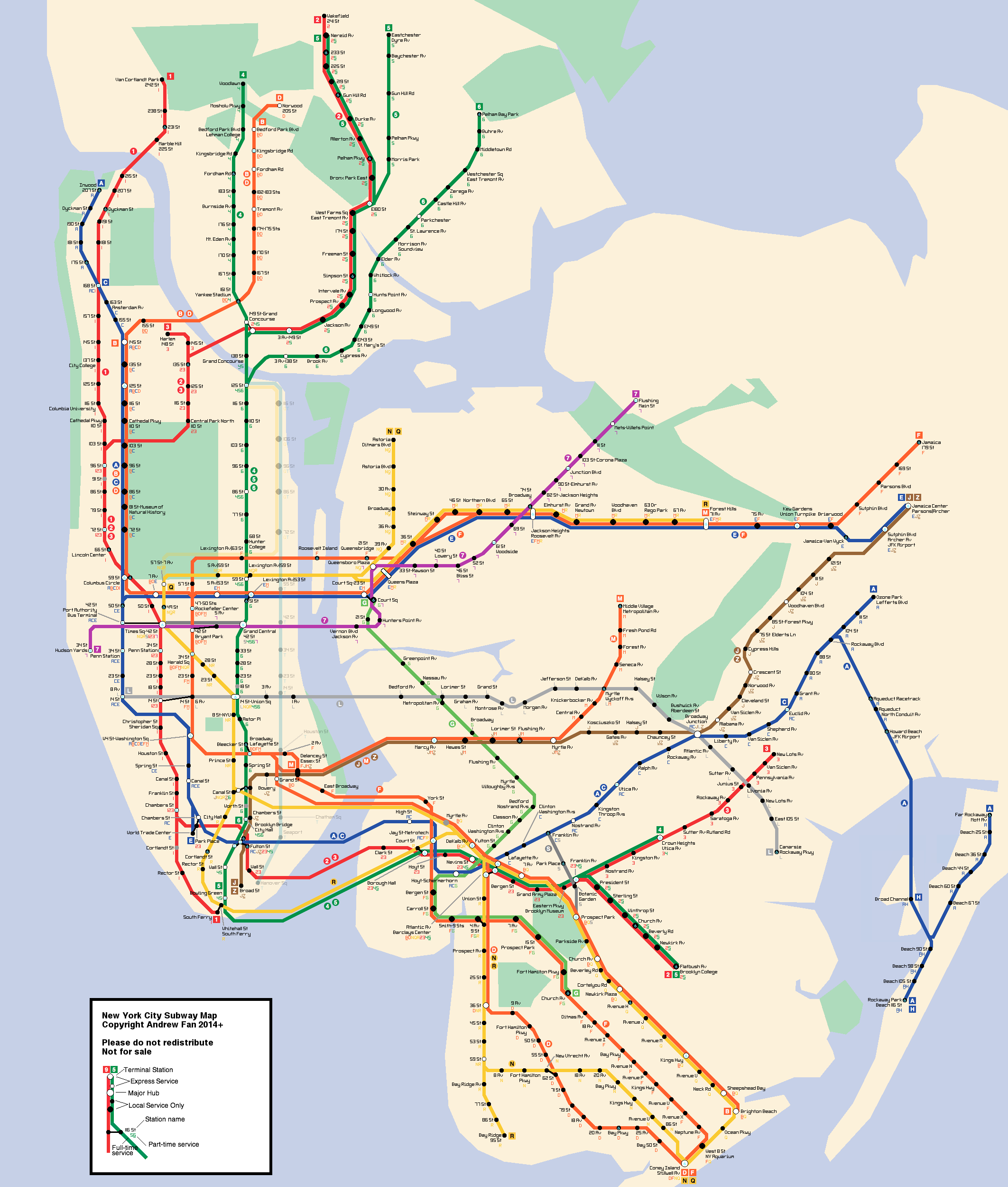
My first major project was a map of the New York City Subway, a project that lasted well over a year. Inspired by a number of sources, the project went through two distinct phases involving tracing the existing MTA map (though converting to a 30/45/60 degree system) and building map components by scratch. Later on a custom font system was employed.
This project was undertaken during my time as a NYC-based railfan and so maintains numerous elements from that time period.
Project X1 (2014 Sept - 2014 Dec) - Coylé City PNG
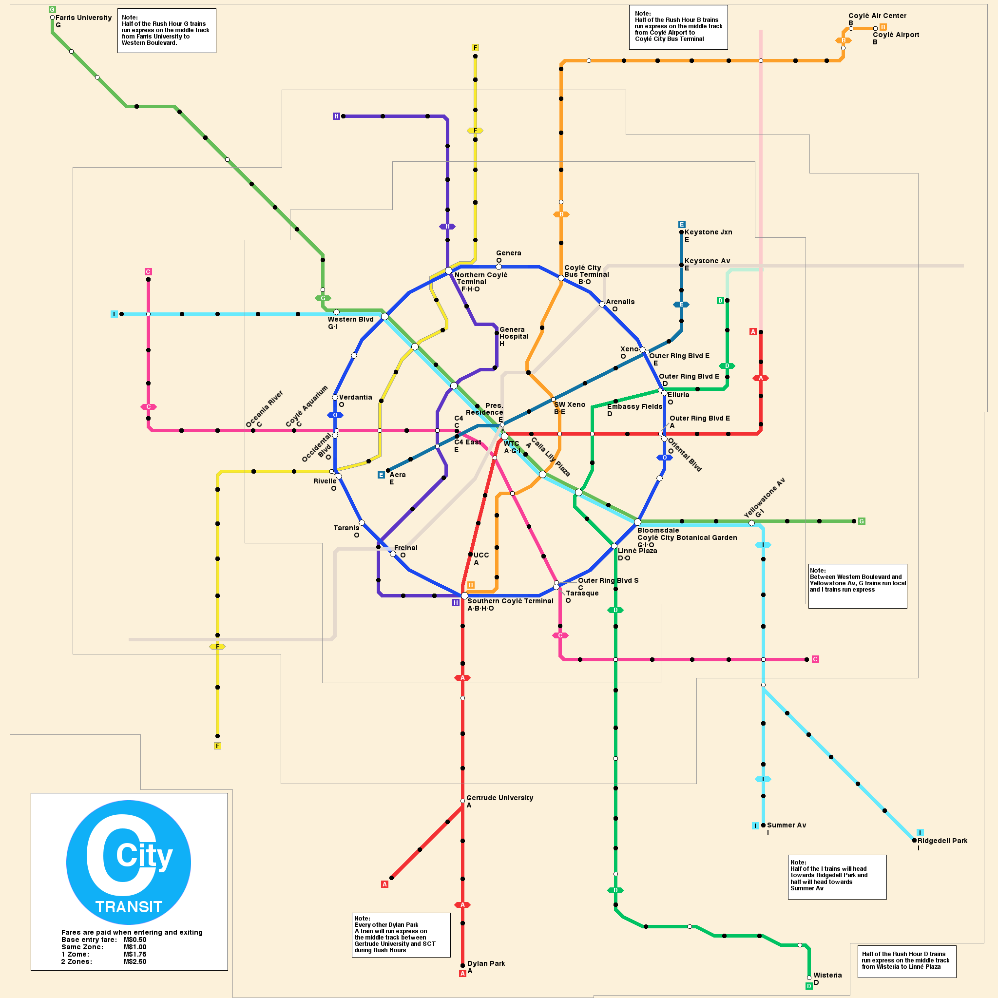
After getting accustomed to the work on my NYC map, I applied the same design system to a preliminary map of a city I was building for a story. With the express purpose of replacing a placeholder map, I began work on my first real attempt designing a city from scratch. As one of my first major projects not tied to the real world, I had the ability to make things convenient for myself and to an extent, I did so.
This project was also undertaken during my time as a NYC-based railfan and so many concepts used in the New York City system made their way into the map, even if they wouldn't necessarily be practical in the network I designed.
Project [18] (2015 March - 2015 Nov) - Shanghai PNG
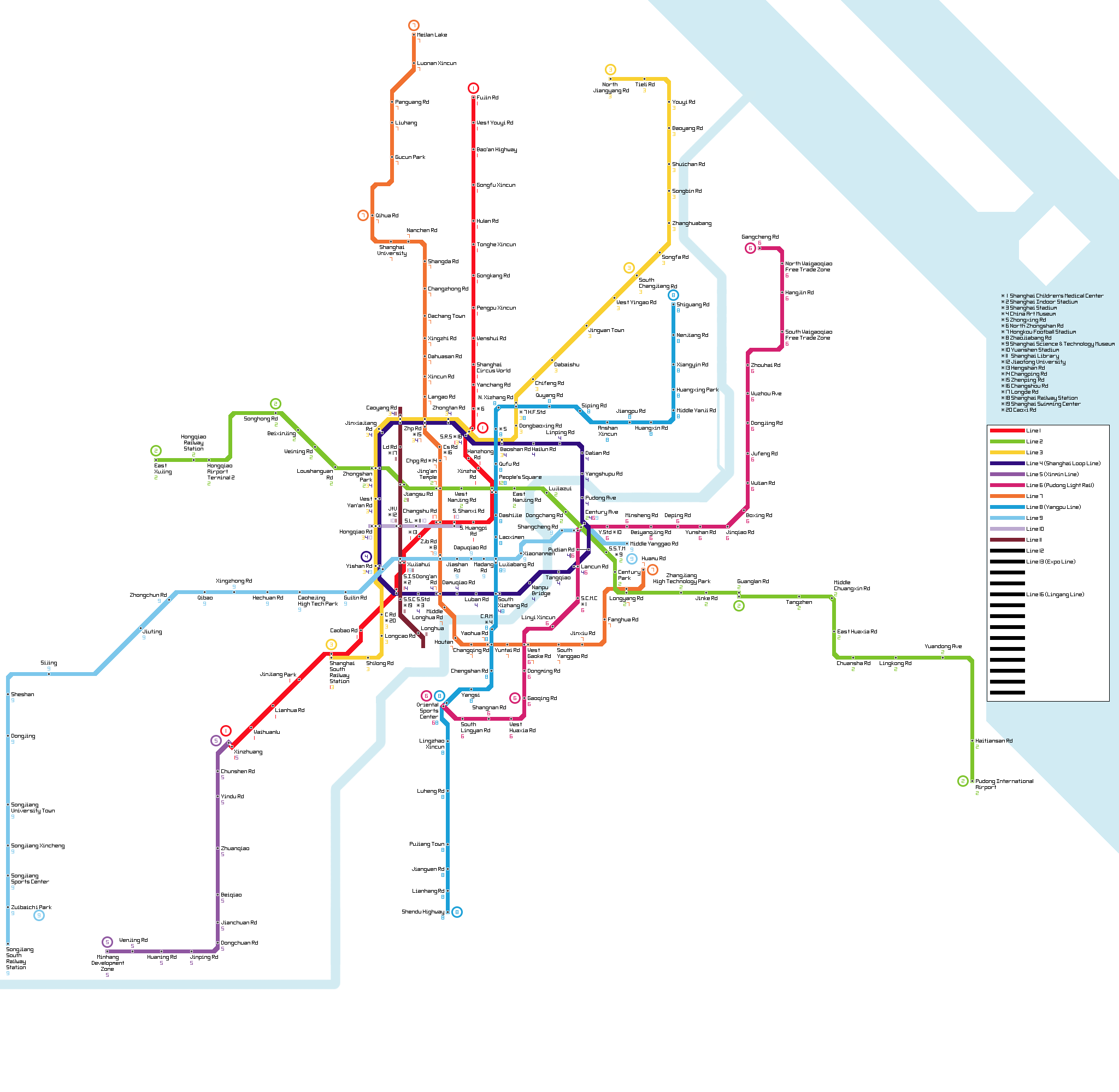
During the late phases of my initial raster map era, I began work on a map of the Shanghai Metro using the systems employed during the later components of the original NYC Subway map. However, I did not adequately futureproof the map and so as new lines were considered, it became increasingly difficult to integrate them into the map without significantly redoing much of the existing work. As my raster era was dominated by difficult-to-move map elements, this resulted in abandonment of the project.
This project taught me firsthand the necessity of futureproofing and planning maps holistically so as to not require heavy reworks for minor but inconvenient changes to the map.
Project X2 (2015 June - 2015 November) - Coylé City SVG
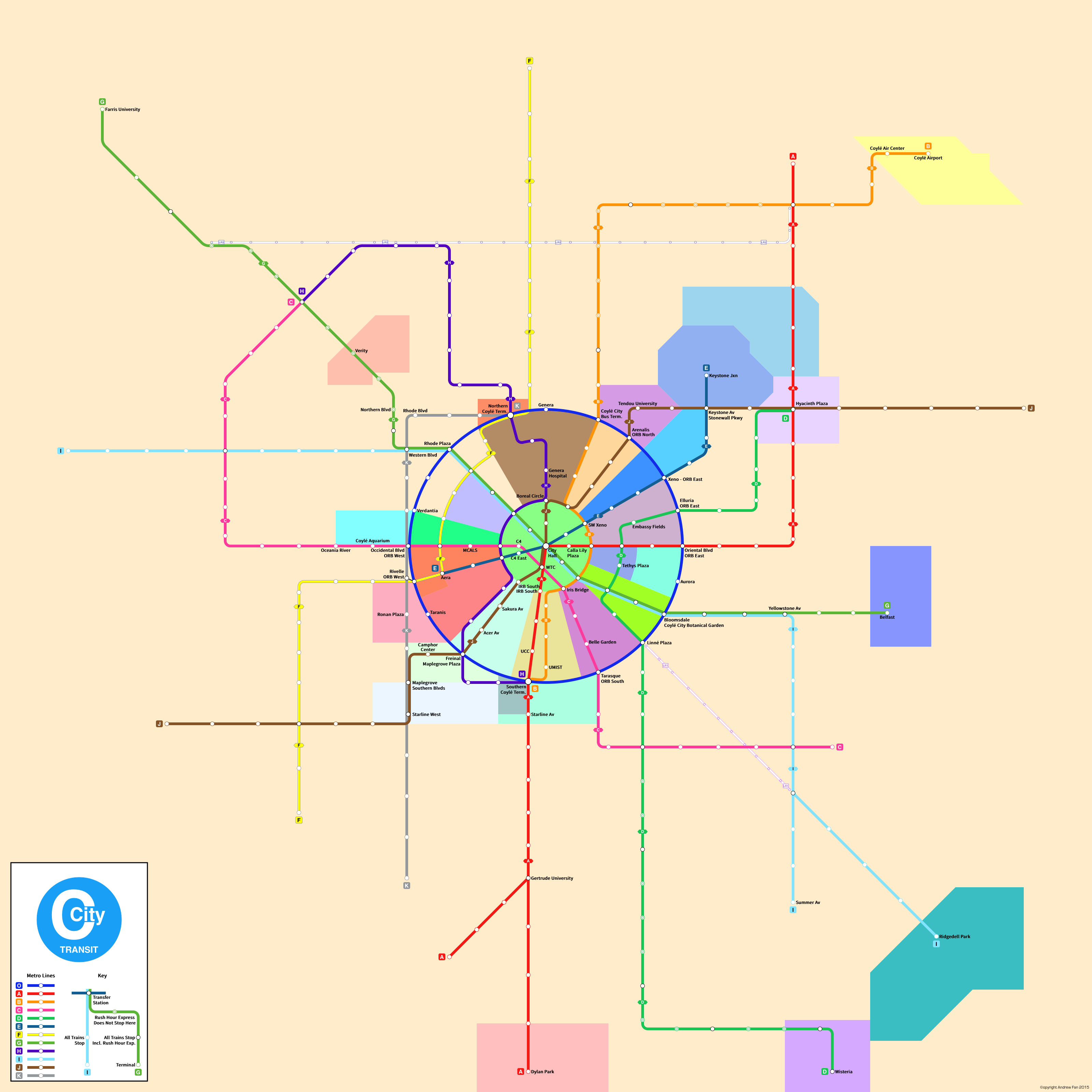
During the evolution of the project involving Coylé City, I reached limitations with the existing map and decided to use a 'fun tool' called SVG to build a new map. This experience tossed me into a new world of pain as the map was forced to be geographic for the city. As a radial city, it featured many strange angles and curves and its usage included showing district boundaries as well.
This experience involved spacing stations based on absolute positions of avenues and streets whose positions were determined prior via other lines having equal spacing of stations, and all of this was complicated by the fact that I was writing SVG in a text editor rather than using software such as Adobe Illustrator or Inkscape. However, it was a good learning experience. In addition, this was around the time that I began following Transit Maps, from where I gained exposure to many good (and bad) practices.
As a final note, this project also saw the creation of my first strip maps, something that would come back much later when I began work on the SVG Strip Map Generator and the Metro Route Atlas.
Project [21] (2015 November - 2016 February) - NYC Subway SVG
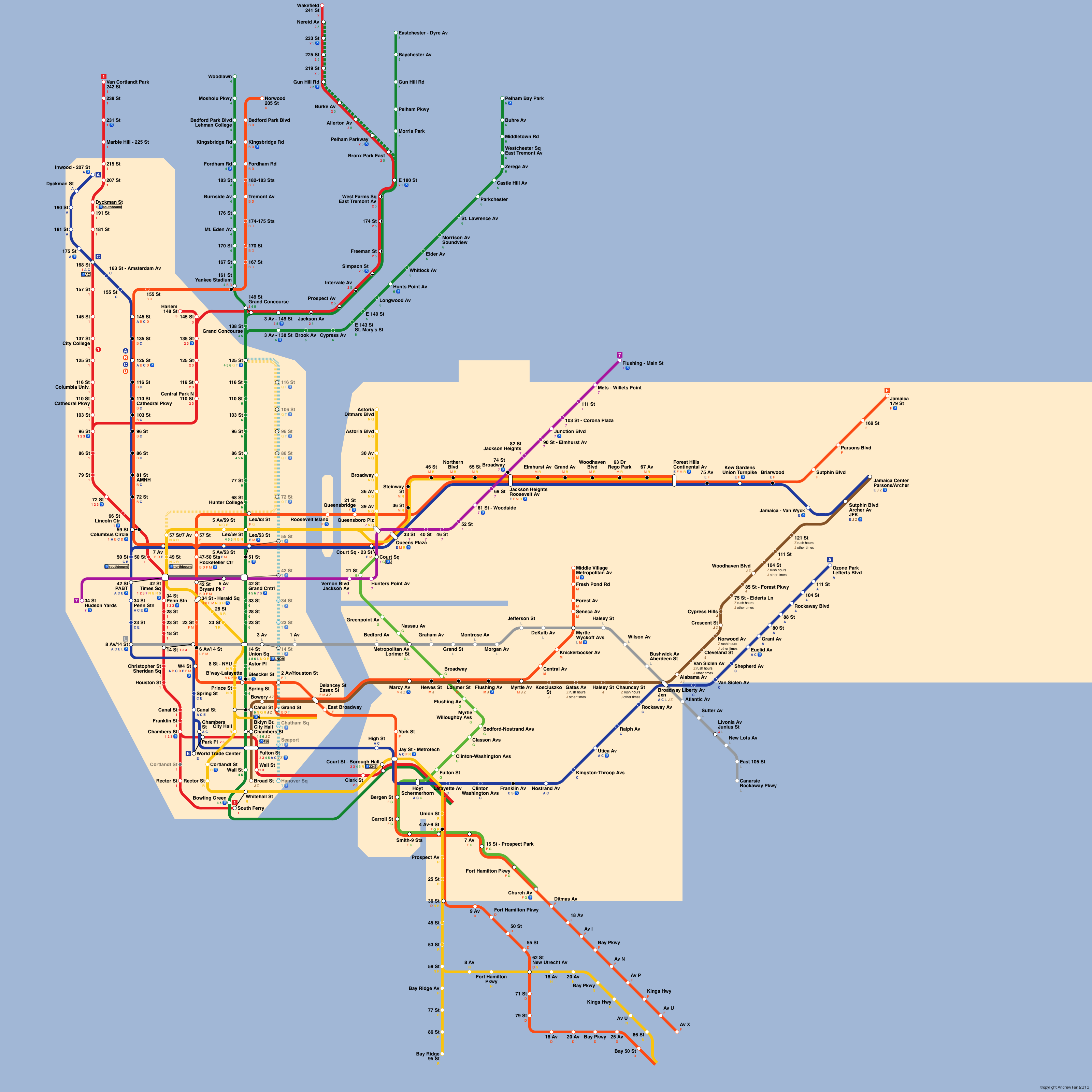
After Coylé City, I decided that it was best to take another shot at a NYC map, though this time with SVG. I got pretty far and did a decently futureproofed job. However, doing the borough boundaries became problematic, as did the way I was handling curves and especially multiple parallel lines on curves and angles. In the end, my obsession with getting numbers done to multiple decimal points reached a tipping point when I needed to thread the Manhattan Bridge lines into downtown Brooklyn, at which point I gave up.
Project [22] (2015 September - 2015 December) - Tokyo Metro SVG Strip Maps
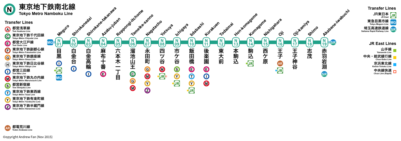
My interest in Strip Maps hit a high when I began working on strip maps of Japanese metro lines. Route icons, through running, vertical text, icons, map keys, etc. The main drawback was the way I handled the maps - manually crafted by hand, with manual spacing and a fixed size format. That combined with other aspects of the project resulted in only a few maps being done to completion, but this project laid the groundwork for the entire SVG Strip Map Generator.
Project [23A] (2015 December 17) - Bylik
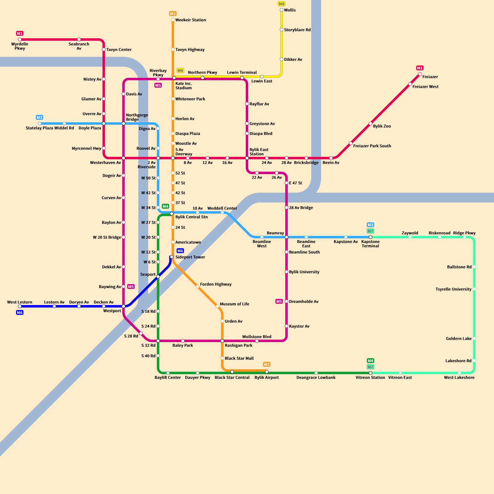
As I experimented with SVG and the NYC SVG map, I began working on a number of small scale maps. Bylik was one of them - thrown together in a single day. Looking back, I'm not very proud of it, but the way I handled line terminal icons in this map would become my de facto standard for years to come.
Project [23B] (2015 December 23-24) - San Francisco MUNI
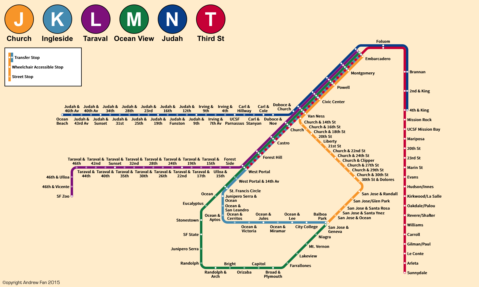
Continuing on with experiments, I built a map of the San Francisco MUNI metro system. Here I learned quite a lot as well - namely, the reason why MUNI doesn't name all of the stops on the streetcar portions of its network. Still, it was a good experience to build, especially given that I was still using the curve system from NYC (though with five parallel lines in this case). This was the map that first featured on my Transit Maps by Sparen Tumblr blog.
Original comments from blog:
Anyways, to start I have a throwaway map I made of the MUNI Metro system of San Francisco, California. I made it shortly before my trip there, and I can see why the official map doesn’t attempt to list all of the street-level stops - there are quite a lot of them.
Colors are from Wikipedia. Unfortunately, it was my first time having so many parallel 45 degree angle lines and my manual SVG didn’t like that. As a result of that and some other issues, the map is not future-proofed. The Central Subway and any possible Geary Light Rail probably won’t fit, for better or for worse.
Project [24A] (2016 January - 2016 April) - Xi'an
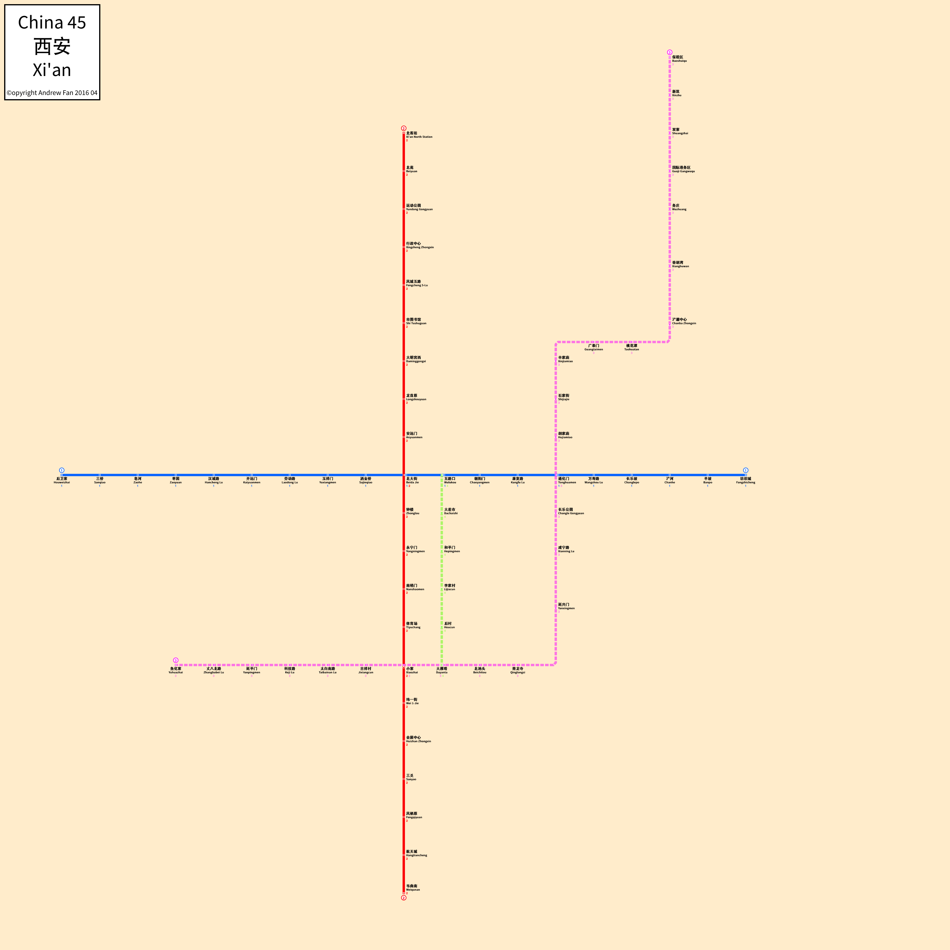
After the entire mess with curves settled down, I decided that I wanted to revisit my Shanghai map or at least the style, and so I began work on my map of Xi'an's metro.
The entire project was a mess due to lack of information. Before then I never really understood the full extent of the chaos that can accompany Chinese metro construction - until the shovels are in the ground and even after, you can expect alignment changes and line renumbering galore. With the limited knowledge I had, I began work.
The main advancement from this project by far was a common map standard. The number of pixels between lines, the location of station name text relative to a station icon, the location of terminal bullets relative to stations, etc. In addition, the transfer icon nightmare where I tried to generate complicated transfer icons began here, on a map that wasn't exactly too complicated...
Project X3 (2016 March) - Delucape-Slatebluff
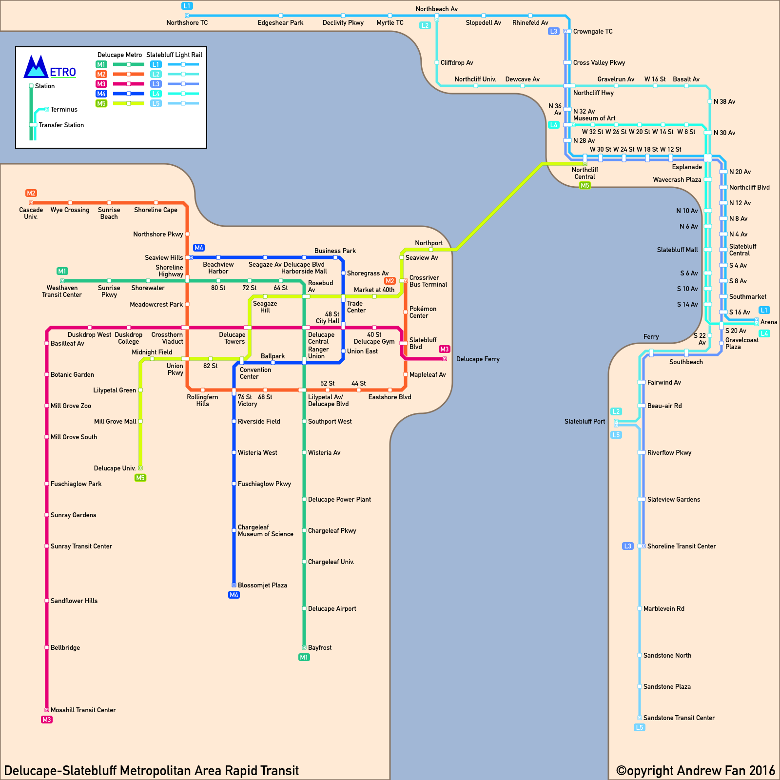
While writing another story, I began to develop a concept for a new metropolitan area and decided that the best way to integrate things together was to build a map of the city. What resulted was the founding of a map key standard that I would end up using for years - the grandfather of the Metro Route Atlas map key standard, if you will. Columns of services with Bylik-style terminal bullets and station icons, usage of DIN, and clean angled lines with well-defined rules for multiple lines turning at a certain point.
The map ended up being one of the most infuriating projects I ever worked on due to my insistence on transfer icons. I insisted on transfers having colors from both lines... except when more than two lines met (Esplanade being the main challenge), things got ugly really quickly from a code perspective. All in all, it remains one of my proudest maps.
Original comments from blog:
Today I finished a three day project, creating a map of an imaginary set of cities (for a Pokémon fanfic, but that’s besides the point).
Although I didn’t intend to, I ended up using colors similar to that of the Düsseldorf Stadtbahn for the light rail and the Delucape side ended up looking like what San Francisco might have been like if Market St didn’t exist.
Overall, I’m satisfied with the project. It’s built to my usual 8-16 spacing scale and the station icons are quite sufficient (inspiration taken from Urbanrail.net). Transfers look nice as well, although some things were squashed in due to space restrictions.
DIN worked well as a font too - I think I prefer it over Source Sans Pro. And in the end, I only had one portion of the map at a 45 degree angle for anything other than a curve, which I believe to be a success (reason being that my station icon can’t handle transfers gracefully on a 45 degree angle).
Project [25A] (2016 April) - Caracas
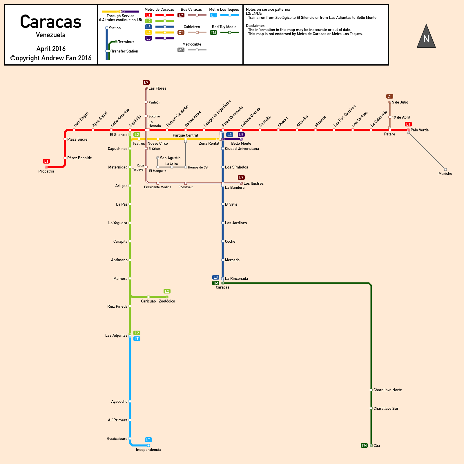
While browsing the world of transit maps, Caracas caught my eye as having one of the most confusing, and so I sought to rectify the problem... only to sink into the mess known as its service patterns. In the end I maintained the same transfer icon system as Delucape-Slatebluff, which made things worse than they needed to be. But the map key and upper left-hand corner title box was here to stay.
I'm not proud of the map by any means. It's unbalanced, has an unhealthy fear of 45 degree angles, and had Venezuela spelled incorrectly when I first submitted it to Transit Maps. However, as with all projects, it laid the foundation for future projects to come.
Original comments from blog:
Finished a 5 day project where I made a map of the Rapid Transit system of Caracas, Venezuela. I used the same style as with my Delucape/Slatebluff Map, but Caracas posed a very different set of challenges.
Caracas’s official map is a complete mess. It’s hard to explain just how much of a mess it is, actually. Their system as a whole is a mess. They branded a one station of Line 4 as Line 5, broke a single service (Metro Los Teques) into multiple ‘lines’ with different route colors, and their official map is a royal pain to navigate, with two different transfer icons, one of which looks like an extension of the line (see any of the Metrocable lines or Las Adjuntas). Oh, and the official map got Las Mercedes and Bello Monte mixed up - which is a shame, because it was a well-advertised extension of their metro system (a new ‘Line’).
Simply put, their official map is a mess. So I sought to make a better version.
In the end, I couldn’t decide between geographic and diagrammatic, so it’s quite sloppy and otherwise meh. But at least I didn’t post lines that don’t exist yet with the same line width and color as those that do. So there is no problem with someone deciding to ride Metrocable Antimano with my map. Of course, they would probably think the Carapita II was a separate station from Carapita, but that’s a whole ‘nother story altogether.
One of the things I debated was how to portray the Line 2/4/5 mess, and how to use 45 degree angles, if I was to use them, since my current square transfer icons don’t nicely work with 45 degree angles. Colors should be pretty similar to the official map, though I settled with one color for Metro Los Teques instead of three. There was also a problem when I tried to shove Line 7 into the map, because it butchered the downtown area, but everything there is still… legible.
Anyways, enjoy!
Project [25B] (2016 July - 2017 April) - Seymyr
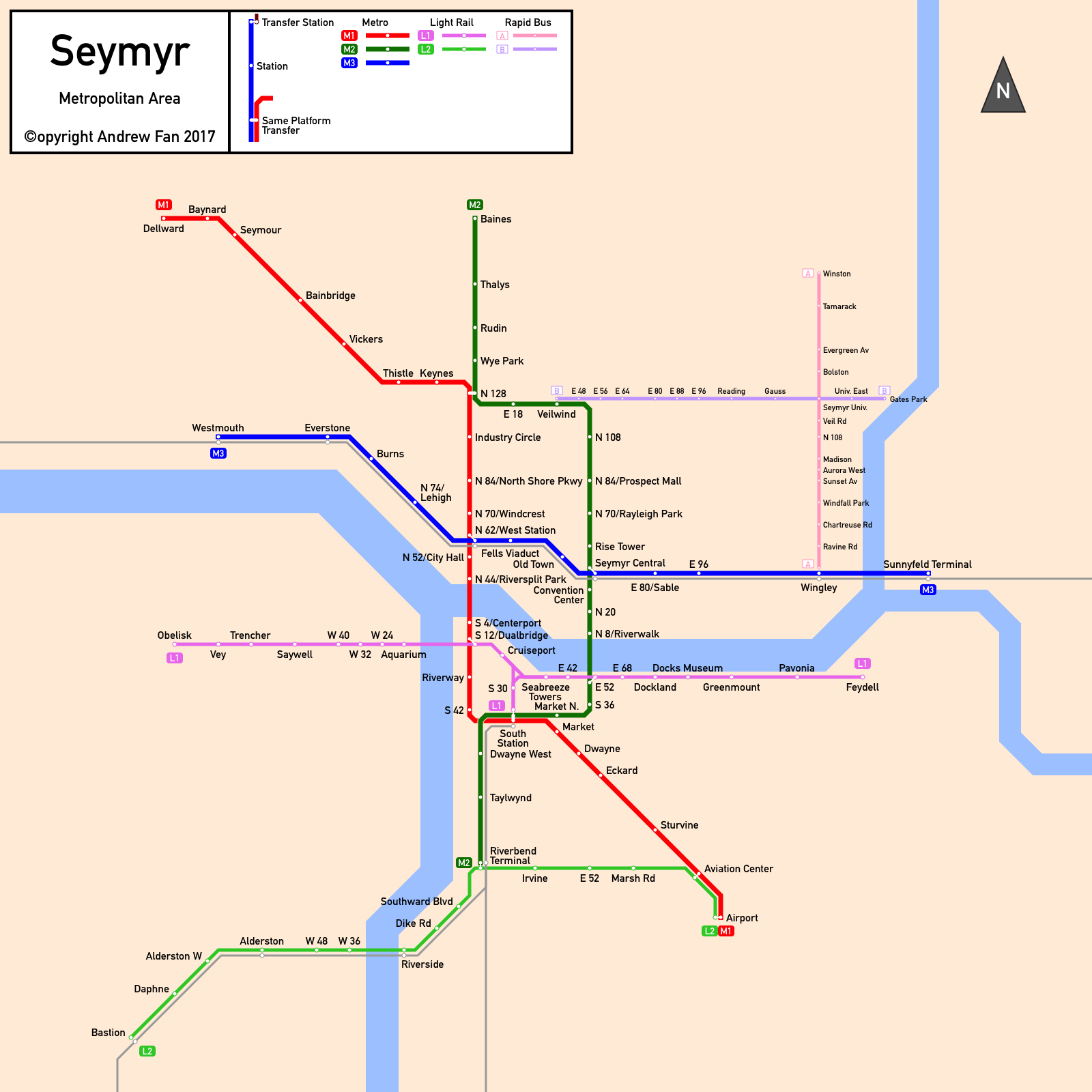
Seymyr was my next attempt at a map. Being a map of a nonexistent city, I had a lot of leeway. Most of the map was done in a three-day period at the end of July, but it took almost a year before I returned to finish the last bits of the map. Successfully cured of complicated transfer icon syndrome for now, my map style came together as I integrated national rail lines with other design components. Perhaps not my best work, but from a city design perspective, it was an interesting project, especially since it was the first map where I showed parallel lines with different modes - something that is incredibly common in the real world.
Original comments from blog:
A random thing I began late July 2016. Worked on it for three days, left it unfinished. Today I decided that it was time to finish it up, so here it is.
Project [25C] (2017 September - 2018 April) - Ternavale
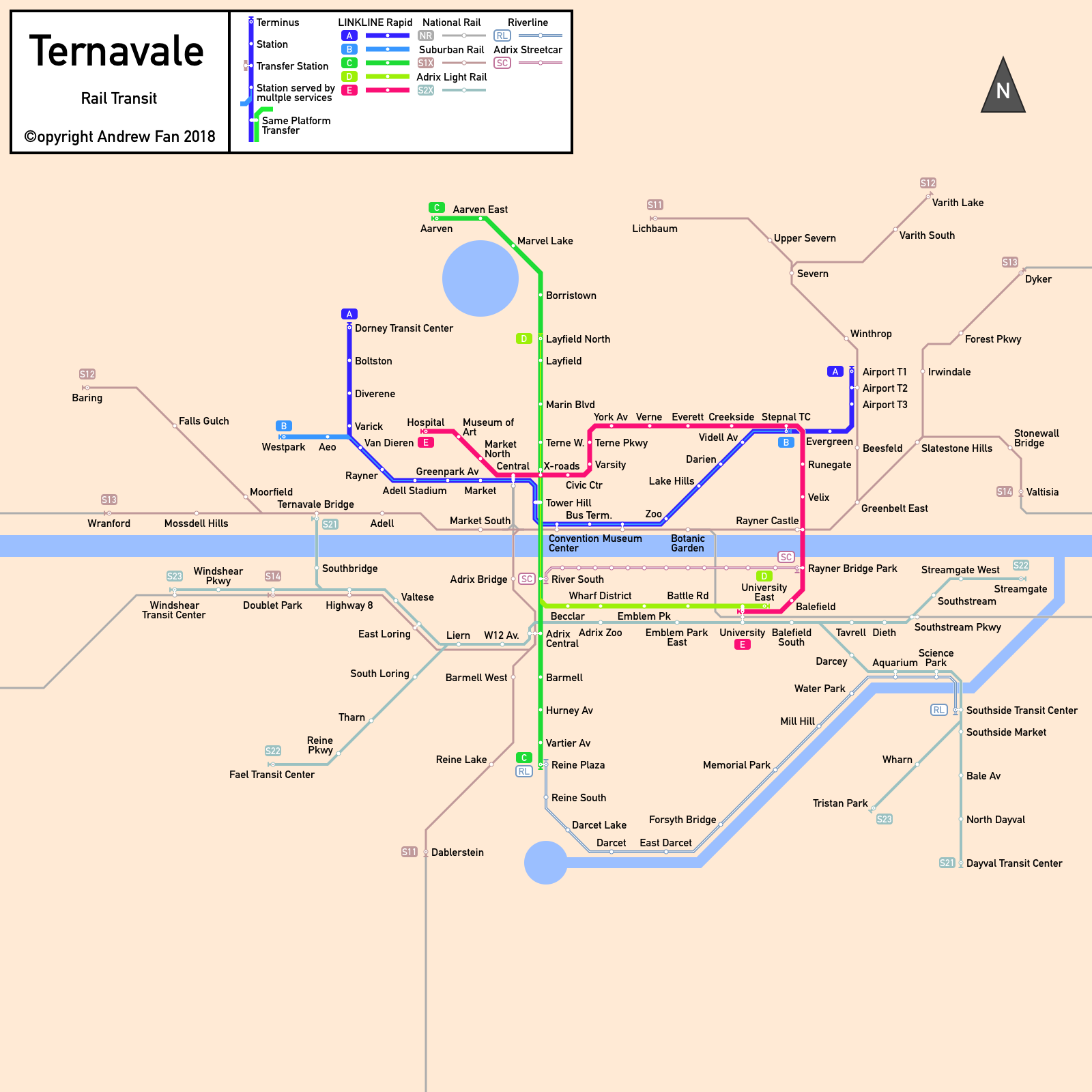
Ternavale was an experiment for how to nicely show interlining different colors, but ended up being a complex project with different modes and companies, with complex terminal icons and other complications. In the end, it turned out to be a work that I could be proud of. As an imaginary city, it was up to me what to do, and with my parallel line standards set, it was a project that went relatively smoothly. Suburban rail, multiple modes, and more.
Original comments from blog:
Another map of an imagined metro area. Work started in September 2017, but slowed down until it was rebooted February 2018 and finished by March.
The two main things I experimented were on this map were a new set of terminal stubs and having different colored lines merging. I think I was moderately successful with both.
Project [25D] (2018 March - 2018 June) - Darvine-Desselvale
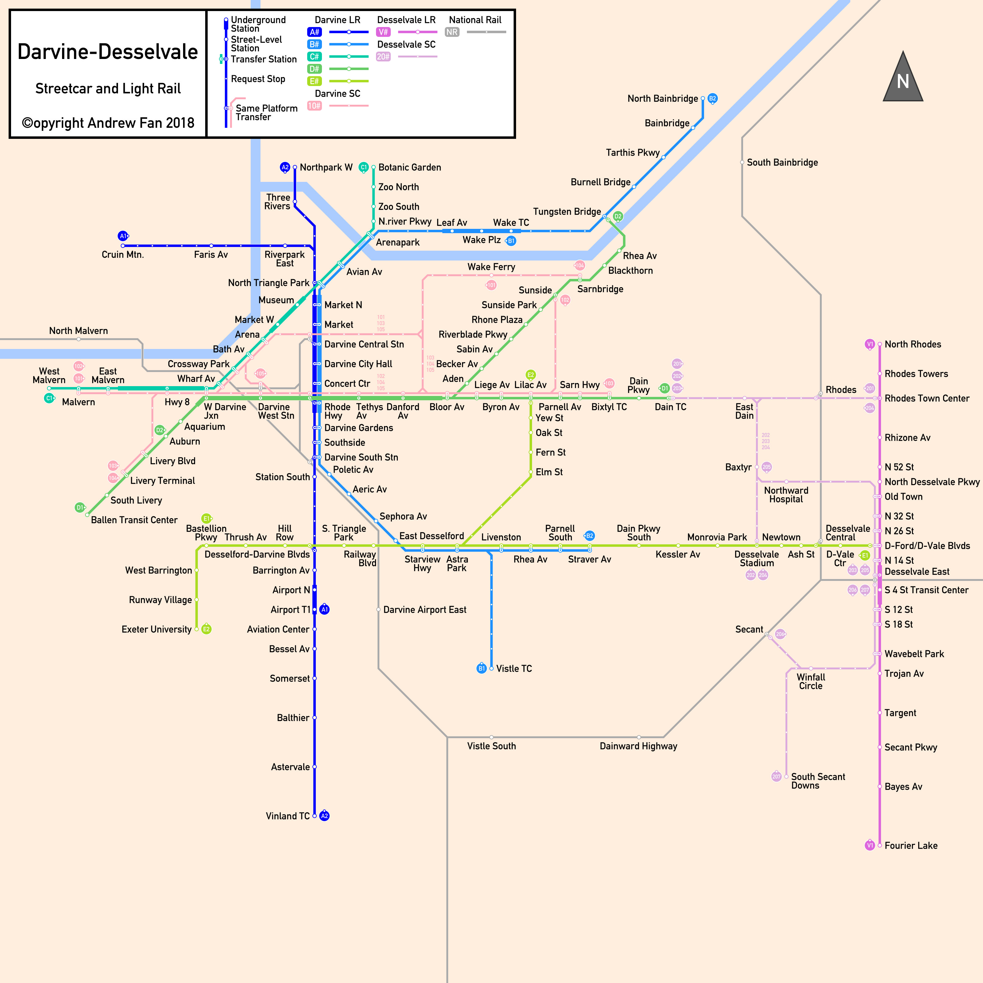
By far the best map I made prior to beginning work on the Metro Route Atlas, the Darvine (later Darvine-Desselvale) map features long, straight corridors and clean exchanges of services. Naturally, I made the transfer icons incredibly annoying to work with, but I combined multiple modes with new background covers where lines crossed rivers and other lines and light rail/surface sectors. In addition, although it wasn't supposed to be multinodal, the city eventually became so, and the format I use for the Metro Route Atlas's terminal bullets originated here. The biggest 'innovation' on this front was showing which *direction* a terminal icon represents, as where multiple lines share the same color and path, it becomes necessary to distinguish which service is terminating in which direction - something that other sites like Urbanrail do not do (and something that many transit operators do not do as well - case in point being the New York City Subway's system for including weekend terminals on the main map). In addition to this, the system was designed in such a way to maximize service on the core on every line, something that was necessary to consider on this map.
This was the last map posted on my blog but it wasn't the end of my map-making.
Original comments from blog:
Today I present another map of an imaginary metro area. Work began in March 2018 and concluded yesterday, June 20, 2018.
This isn’t my most complex map, but it was interesting to make - using strong corridors to provide defining geometry, ensuring that crossings were minimized and that it was always clear which line went where, etc. Overall I’m pleased with the result.
Project [26-01] (2018 November - 2018 December) - Theria City
For yet another written project, I began work on a new city map. Unlike Coylé City and Delucape-Slatebluff in the past however, I numbered this project with the same format as the other mapping projects.
This time I reinherited transfer station syndrome to my detriment (as some stations just became painful to make transfer icons for). In addition, this project marked the adjustment to the Legend system used as a template for early iterations of the Metro Route Atlas. Overall, it's a project I enjoyed working on and one that has served its associated project well.
Unfortunately, due to concerns over the names used in the map, I cannot show it here.
Project [27-0001] (2019 January - Ongoing) - MRA Buffalo
Link: Buffalo, New York, USA
Buffalo was the first city tackled for the Metro Route Atlas. It was the first shot at using the template, and although it was an incredibly simple system, it set the standards for what I wanted the rest of the project to be like. Based on geography, yet not tied to it. Simple and easy to use, yet informative beyond the wayfinding itself. Focused on the urban environment, leaving out infrequent long-distance services. Naturally, the map evolved over time as new standards came into play later, but as the first stepping stone for the Metro Route Atlas, it deserves its rightful place.
Project [27-0002] (2019 February - Ongoing) - MRA Miami
Link: Miami, Florida, USA
I chose Miami as the second testing city for the Metro Route Atlas, thinking about its simple branched system. In that thinking, I entirely forgot about the Metromover.
Miami had a lot of firsts for the project. Line crossings, river crossings, text on water, commuter rail, and most importantly, the inset with directed services, text-labeled services, and the metromover as a whole. It turned out to be an incredibly challenging project but one that I was satisfied with in the end.
Project [27-0003] (2019 March - Ongoing) - MRA Washington DC
Link: Washington, District of Columbia, USA
As the nation's capital, Washington DC was the third city I chose for the Metro Route Atlas, and it was rife with challenges. A dense downtown, extensions far into suburbs, and geography strictly tied to its administrative boundaries. It was a necessity to use a diagrammatic map for this project, and so geography was distorted readily to make way for all of the stations. And on that note, I used smaller fonts here in order to fit things in the downtown. However, after it was all done, I found myself quite proud of the map, which shows nearby commuter services as well as the metro. It was the first map to necessitate considering weird service patterns (though I ended up not showing them) as well as under construction projects. It was also the first project where the Legend got in the way of services rather than the other way around.
Project [27-0004] (2019 March - Ongoing) - MRA Baltimore
Link: Baltimore, Maryland, USA
Compared to DC, Baltimore was incredibly simple to set up... except for the geography. As a city where the downtown and relevant transportation options revolve around the layout of a harbor, it was surprisingly difficult to work the harbor into the map in a way that worked, but I feel that I achieved that well.
Project [27-0005] (2019 April - Ongoing) - MRA Charlotte
Link: Charlotte, North Carolina, USA
By the time I had reached Charlotte, most of my standards were in place, allowing for me to speed through the map's development in a single day. Here the main concerns were station spacing, as well as text placement due to the streetcar having incredibly long station names.
Project [27-0006] (2019 April - Ongoing) - MRA Salt Lake City
Link: Salt Lake City, Utah, USA
Salt Lake City was the first project where properly handling geography ended up messy. Unlike DC, where I could squeeze and stretch however I wanted, keeping things neatly aligned in this map, especially with so many parallel lines, was difficult. It was also the first map to feature a bus service of any type, and that required some adjustments to the templates. To be fair, I could have left it out, but I felt that it was an important enough corridor to show on the map even if it wasn't proper BRT. In addition to this, Salt Lake City was the first time the metropolitan area's name quite mattered (Wasatch Front), and so I decided to incorporate that into future templates.
Project [27-0007] (2019 April - Ongoing) - MRA Cleveland
Link: Cleveland, Ohio, USA
Disclaimer: Due to more stringent minimum standards for definitions being imposed during Jan 2020 site maintenance, the Cleveland State Line and MetroHealth lines were removed from the map entirely due to the former requiring a timetable to use and the latter due to incredibly low frequencies on branches and no BRT or rapid bus features. The original content of the post here has been maintained for archival purposes.
Cleveland posed a number of challenges. Distances, fitting in the light rail's streetcar portion, and dealing with the HealthLine were the most pressing.
In the end, I chose to used small angled font for the streetcar portions, and I decided to not show the HealthLine stations - after all, when there are uptown only, downtown only, and seasonal stations, it can get hectic, not including the sheer *number* of them. I also ended up showing some of the other less-BRT services with some timetabled stations. Otherwise much of the map would have felt empty. Overall not my worst job for sure.
A few months later, as standards for the MRA changed, I went back and showed all the HealthLine stations. It required a bit of reworking but I feel that it's definitely more useful for people using the map now that the information has less room for ambiguity.
Project [27-0008] (2019 April - Ongoing) - MRA Atlanta
Link: Atlanta, Georgia, USA
Atlanta was by far one of the simplest major systems to implement. No water, only one major transfer point, and a streetcar that barely goes anywhere. Five Points was by far the most challenging part of this project, and I think I handled it in a relatively nice way. After all, I'd use the same system again...
Update: Several years later, the map was somewhat remade, using a wider scaling between stations to fit the Summerhill BRT. Same general themes apply, except that the northern part of the Red Line had to be horribly compressed due to it going so far out, and my insistence on having the east-west metro lines be roughly centered on the map.
Project [27-0009] (2019 April - Ongoing) - MRA San Juan
Link: San Juan, Puerto Rico, USA
Puerto Rico's capital ended up being a fairly simple map, unfortunately. A single line that doesn't go to downtown, and a map where most of the work went into water features.
Project [27-0010] (2019 April - Ongoing) - MRA Seattle-Tacoma
Link: Seattle-Tacoma, Washington, USA
Seattle and Tacoma currently have separate systems. However, in the future, plans call for connecting the two. In addition, far to the north of Seattle in Everett, light rail extensions are planned. How to handle this? My answer was to put both in the same map - and one giant map at that. The Seattle-Tacoma map was the first non-square map of the Metro Route Atlas project and the geography became a problem very quickly. How to balance the necessity of detailed geography in Seattle's core while not distorting things too much? A difficult design decision indeed. My insistence on including the streetcar stops also contributed to a congested downtown with some geographic license taken. However, I still feel that the map is pretty good... for now.
Project [26-02] (2019 May - 2019 June) - Squamatarn City
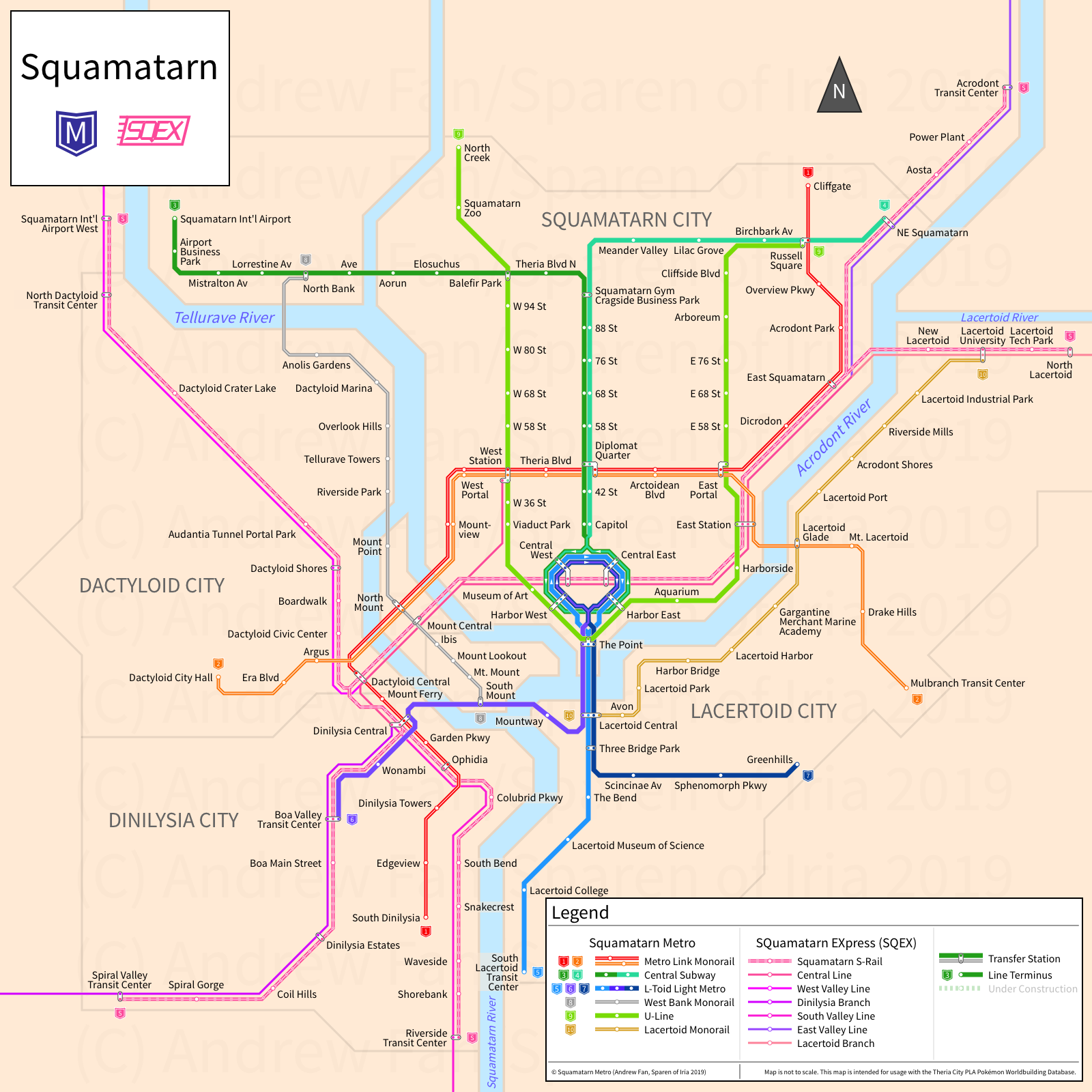
For the same written project as Theria City, another map. This time I drew out the entire thing on paper, and in the end it became the first time I had faithfully taken a paper map of a nonexistent city and turned it into a digital map. And wow was it a complex project. I designed icons, created new advancements in Legend design, made S-Train standards, and implemented an incredibly complex map. Merging single-directional loop services, all kinds of modes and services, dealing with a gigantic legend that got in the way of the lines... all of it was there.
Project [27-0011] (2019 June - Ongoing) - MRA New York City, Newark-Jersey City
Link: New York City, New York, USA; Newark-Jersey City, New Jersey, USA
When this map came up next on the to-do list, I was filled with dread. I had already failed once. But this time I was prepared. My scope was large. And so I did everything I could to prepare. Ample spacing between lines. Separate local and express services. A smaller font for every station. Route identification. Commuter rail integration. A massive endeavor that came out pretty well, even if I had to do geography distortion on a level I had never done before. But in the end, I had a map of New York City and North New Jersey, with variations for service changes and weekend service.
Project [27-0012] (2019 July - Ongoing) - MRA Hempstead
Link: Hempstead, New York, USA
Originally I never planned to do Hempstead. However, the RPA recommended converting two LIRR branches to light rail, and the commuter rail here operates pretty frequently. Well, at least that's what I thought going in. The end result was a map almost free of line crossings, with Jamaica station turning into a... thing. I had to do an uncomfortably large amount of research for this map since service patterns on the LIRR are a mire of looking in different places, but things turned out pretty well in the end.
Project [27-0013] (2019 July - Ongoing) - MRA Phoenix
Link: Phoenix, Arizona, USA
Phoenix was challenging due to spacing issues. The streetcar wouldn't fit, and the stations on the eastern branch wouldn't fit. So I brought back diagonal text, and made some geography-defying adjustments to the streetcar. But in the end, it was a breath of fresh air to get the Phoenix map done so expediently.
Project [27-0014] (2019 July - Ongoing) - MRA Norfolk-Virginia Beach
Link: Norfolk-Virginia Beach, Virginia, USA
Even though building the SVG map for Norfolk only took 45 minutes, I had a deep focus on system expansion and had long internal debates about how much futureproofing I wanted in the map. The reality is that the distance between Norfolk and Virginia Beach's population centers is not that far, and they are all part of the same metro area. The right of way being used for the light rail is there, ready to be converted should funds be available. And so I debated whether or not to include Virginia Beach, and if so, how much. In the end, I settled for dropping most provisions. If they decide that they want to expand service, adjusting the map isn't too difficult.
Project [27-0015] (2019 July - Ongoing) - MRA Pittsburgh
Link: Pittsburgh, Pennsylvania, USA
The biggest issue with Pittsburgh's map was how to treat its busways. When considering how to handle the map, I considered a number of solutions - one of which involved using different line widths for on-street vs. on-busway. I used a similar solution for Darvine-Desselvale, and it's similar to what Urbanrail.net does for Stadtbahn services. However, that's not as good for a map that's targeted at potential riders.
I eventually settled for full width lines, with small station icons to represent (most of) the stops off the busway. I had provisioned those for this very purpose back when I initially added support for BRT into my template, but in Salt Lake City I simply put an asterisk and a note since the Magna Loop would have looked terrible if I had placed the actual street stop icons.
My final solution works, I feel. It sets a decent enough precedent for what comes next, but doing what I did here caused me to revise my Cleveland map as well as detail my map standards better.
Project [27-0016] (2019 July - Ongoing) - MRA St. Louis
Link: St. Louis, Missouri, USA
By the time I had gotten to the St. Louis map, generating maps had pretty much become a routine. Copy the template, update the legend, add notable water features, and take existing sketches, adapting them into lines on the map. Of course, the real challenge comes in station spacing and manipulating geography.
In this case, a la Seattle, I thought it would probably be OK to include the stations for the Delmar Loop Trolley, since there aren't that many. In the process however, the area got reworked about ten times as I moved lines and stations until things were able to fit. Due to The Pageant's name being long enough to cause problems, the entire line goes farther west on the map than it really does, and there are some mildly annoying adjustments that were made. But in the end, things are pretty decent here.
Project [27-0017] (2019 July - Ongoing) - MRA Houston
Link: Houston, Texas, USA
When working on the Houston map, I was finally forced to make a decision that I had actively avoided in the past - showing highways on the map. Like many other cities in the USA, Houston has a highway that loops around the city core, and without many geographical landmarks to help position things, I decided that showing the surprisingly rectangular I-610 loop would be good for wayfinding and general positioning. The Buffalo Bayou was approximately the same location as I-10, so I decided that the river (stream?) was sufficient for that aspect of wayfinding.
Aside from the highway loop, the biggest challenge was the Uptown BRT line. Finding reliable information on the project was surprisingly difficult, though I hope that information will be easier to come by once the project opens to the public.
Project [27-0018] (2019 Sept - Ongoing) - MRA Minneapolis-St. Paul
Link: Minneapolis-St. Paul, Minnesota, USA
Minneapolis and St. Paul have a rapidly expanding network, and now equipped to handle BRT with my new template, I expected the map to be fairly simple to set up. To be blunt, I was quite wrong, as the Twin Cities have their rapid services on different streets and don't have actual BRT (yet). In addition, they have a lot of lines under construction. It became a question of how much to simplify in order to fit everything on the map while adequately futureproofing to avoid having to make major changes down the road, and I think I did a decent job, though things will undoubtedly change soon as new routes open.
Project [27-0019] (2019 Sept - Ongoing) - MRA Los Angeles
Link: Los Angeles, California, USA
Of all the cities in the USA, Los Angeles is the one with the largest rail expansion. As of the making of the map, they were building a Gold Line extension, the Regional Connector, and Crenshaw LAX as well as doing preliminary studies for a number of other corridors. In addition, they were transitioning to lettered lines from colored and named ones in a process that would result in a number of service changes.
The biggest issue when making the map was simply FITTING everything. Currently, the urban rail and rapid bus network is heavily concentrated on the west side of the river, while the east side of the river is primarily commuter rail. However, a lot of planned expansion is in the east, so I couldn't just focus on the western part. And so Union Station ended up sort of centered, and I had to move the name of the city to the middle in order to allow for the Orange Line to fit.
The Regional Connector was probably the biggest problem when trying to fit things. Normally I don't like using lines to note station names that aren't directly adjacent to the stations. However, that's preferable over covering a line with a station name or ambiguous name-station matching. And so the Regional Connector ended up with many of those extensions. This is, of course, ignoring possible eastward extensions of the Red/B and Purple/D Lines, or shoving the West Santa Ana Branch inside the map. It would be possible, but I'd probably end up shifting the river to the east and moving the Gold Line stations closer together.
Overall, the Los Angeles map was a worthwhile project. Not on the same level of New York City in terms of complexity, but definitely the third most complex project in the US. The second? The San Francisco Bay Area. Now THAT will be a good challenge to map in a user-friendly way.
Project [27-0020] (2019 Sept - Ongoing) - MRA Denver
Link: Denver, Colorado, USA
In the USA, Denver is probably the light rail network with service patterns closest to those of legacy tram networks, with incredible focus on transfer-free point-to-point services. This heavy interlining means that a different route is attached to every service pattern, resulting in a large number of different services on what is physically a few different lines of track. In terms of map making, dealing with this kind of thing will be the norm when I begin covering cities that never tore up their tram networks, so it's some good practice. Regardless, the interlining was the most hectic part of the map, but since there aren't actually that many stations, it wasn't too bad to make.
Project [27-0021] (2019 Oct - Ongoing) - MRA Chicago
Link: Chicago, Illinois, USA
Chicago is known for the Loop and for its street grid. Given that my map was to be restricted to multiples of 45 degrees for angles, something had to give.
This map was challenging - not only to align as many streets as possible even with Commuter Rail going at awkward angles, but also to fit the loop in without an inset. Unlike Miami, there's nowhere good to fit the inset, and I kept readjusting the rivers and lake on the map in order to crush the entire thing in. My insistence was on showing the entire loop without an inset and to an extent, I succeeded. However, it meant that geography got pushed and text labels struggled to fit. In addition, the transfers at the loop are an incredible mess, with four commuter rail terminals and nearly every line shoving their way into the same small area. However, I believe that I still managed to clarify which transfers are free and which ones are not by connecting only the lines that were relevant.
Overall, although the south side had all of the north-south streets misaligned, I feel that I did a pretty decent job.
Project [27-0022] (2019 Oct - Ongoing) - MRA Hartford
Link: Hartford, Connecticut, USA
After doing multiple complex networks consecutively, I decided to grab a project from the simpler side... except that Hartford's busway is a trunk line busway like Pittsburgh's Yellow Line/South Busway. As a result, I was torn with regards to which services to show. Do I just show the trunk line? Do I show a specific service? In the end, I chose to show the 101 local service, ignoring all others. It's the one you'd take for the busway most of the time anyways (102 is the other all stop service, but comes much less frequently). I also had to do some messy things with the two street stops, but I think it turned out OK.
Project [27-0023] (2019 Oct - Ongoing) - MRA Philadelphia
Link: Philadelphia, Pennsylvania, USA
I knew Philadelphia was going to be moderately complicated. However, with its almost-an-S-Bahn and numerous trolley routes, making a map turned out to be a heck of a lot more complicated than anticipated.
The subway lines are easy to map out. However, the streetcar lines and regional rail form a mass of stations in the southwest, resulting in incredible cramping. I chose to show all streetcar stops, though labeling names was a lost cause for the most part since they effectively stop at every. single. intersection. It was an experience similar to marking every single bus stop in a citywide network, and by locking myself to a 45/90 degree system, I was forced to have misaligned streets. In the August 2022 revision, the handling of the streetcar stops was revised, giving the map more breathing room.
It was, however, the stations and the way the regional rail system works that threw everything into chaos while making the map. The 36 streetcar gets actual platforms when it transitions to a dedicated ROW near the airport, while the Sharon Hill line has two random streetcar stops (which I ended up leaving as stations for consistency). However, this was nothing compared to the regional rail network. Space was valuable, and I ended up doubling up lines whenever possible. However, it was on the Glenside Combined portion that I faced the most trouble. Fox Chase and Chestnut Hill East split off after Wayne Junction and don't show up in the timetable for Glenside Combined, but there was no real way to fit them in while also having enough space to show the strange stopping behavior at North Broad and the separate North Philadelphia stations for Chestnut Hill West and Trenton. The Glenside Combined itself is a remnant of poor decisions made years ago where there was a line imbalance between the east and west sides, resulting in most Airport trains going to Glenside (on paper) and Warminster (in reality). I didn't want to include it but it made life easier while designing and the key reflects the change. Of course, the *actual* interlining is much more complex than listed in the map key, but I think I nailed down... some of it, at least.
Overall, the Philadelphia map made the trouble I had fitting stuff into the DC map look like a joke. When the densest parts of the network aren't in the central part of the city, things can get a little hectic.
Project [26-03] (2019 Nov) - Chelicerant Town
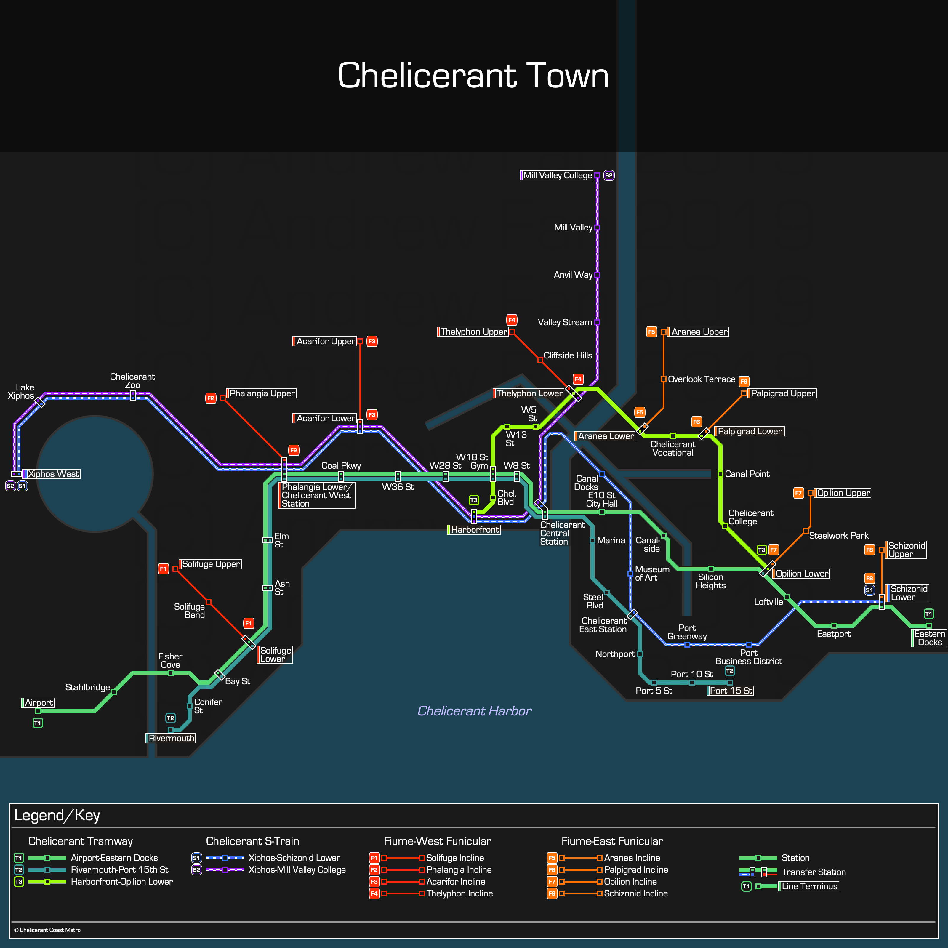
In the same category as Theria and Squamatarn before it, Chelicerant Town's map was made with complete freedom, so I took the opportunity to experiment with a few things. The actual design was originally made on paper with the expectation that it would be adapted, and it was a much smaller map in terms of content to be put in the same space, so I had more freedom to fit things in. After a few hours I went all in and swapped the color palettes over to the dark side, which showed the lines much more clearly, and gave it a Montreal vibe (to an extent). In addition, I tried out the 'have a colored bar at terminal stations' concept, and decided that it wasn't worth it, even though I left it in the final version. Overall, an interesting project.
Project [27-0024] (2019 Dec - Ongoing) - MRA Boston
Link: Boston, Massachusetts, USA
Boston was one of those cities where I was very worried about whether or not it was going to be possible to shove everything into one nice square. The main challenges with Boston were the Green and Silver Lines - the Green Line should not dominate the entire map, and the Silver Line's idiosyncrasies had to be taken into account
In the end I think I reached a manageable series of tradeoffs. Both the right and left sides are cramped at the center due to the Green Line but pretty much everything managed to fit. And I adjusted the geography in order to get some extras to fit in, such as the Stoughton Branch. Overall, not necessarily my best work (and definitely not ready for the North-South connection if that ever becomes a reality) but not my worst.
Project [27-0025] (2019 Dec - Ongoing) - MRA Las Vegas
Link: Las Vegas, Nevada, USA
Like usual, I did hours of research into the page and the routes. However, once I got started making the digital map, it took a grand total of 68 minutes to complete it, including referencing a book and multiple other sources since Transport Politic doesn't have the SDX's alignment. Astonishingly smooth and a testament to how efficient mapmaking can be with smaller systems when focusing exclusively on the rapid transit lines.
Project [27-0026] (2019 Dec - Ongoing) - MRA San Diego
Link: San Diego, California, USA
I have no idea why I left most of the Californian systems to the end of the first phase of the Metro Route Atlas. Perhaps seeing multiple interlined lines terrified me at the time? Regardless, San Diego's map suffered for the same reason as Chicago - forcing my map to lock to 45 degree angles and a compact downtown resulted in some rather unfortunate behavior on the Orange and Green Lines. Still, getting some of the stations more or less lined up eastwards was more important than producing equally spaced stations for this map, so I went that route even if I violated it for most of the map. Overall, a moderately challenging map to round out the year.
Project [27-0027] (2020 Jan - Ongoing) - MRA Sacramento
Link: Sacramento, California, USA
Sacramento was the first map of 2020 and was difficult for the sole reason that the downtown area is full of one way stations and routes. One of the design decisions I had to make was the treatment of the Green Line and in the end I chose to show it separately instead of overlaid over the Gold Line. As a result, six lines go through downtown in the map, not unlike in Denver, which had it worse. The catch here is that the stations are asymmetric, and station names are long. In the end I made the single-directional stations have a smaller font, and that generally solved the issue.
I've done plenty of maps before so this one wasn't any more challenging, but there are always decisions to make. And in this case I think it's not a bad job.
Project [27-0028] (2020 Jan - Ongoing) - MRA Richmond
Link: Richmond, Virginia, USA
Richmond is a very asymmetric city, with a quick cutoff at the east end of the city. In addition, this was the first map where I didn't draw a draft prior to making the vector map. In retrospect, making the draft probably would have been a good idea. Then again, it was a fairly simple project. One line with a little jig.
Project [27-0029] (2020 Jan - Ongoing) - MRA Dallas
Link: Dallas, Texas, USA
Of all of the tram-train style light rail networks in the USA, Dallas has the most extensive. As of the time of writing, it has the longest network in the USA. However, this is achieved by the light rail lines diving deep into the suburbs, covering vast distances along expressways and railroad rights of way. I made the decision to not group Dallas and Fort Worth into the same map, and I feel that it was the right decision. With such a sprawling map, it was necessary to make it partially diagrammatic, and some of the simplification feels more arbitrary than usual. Then again, the official maps don't seem to follow a standard either.
This map was challenging - a highly compressed downtown with far reaching lines in every direction. Downtown streetcars had to coexist with a regional light rail system, and so something had to give - in this case, the M-Line Trolley's stops. Overall, not necessarily my best map, but a worthwhile challenge.
P.S. This was the first time I actively included easter eggs inside the map. Kudos for those who manage to find them.
Project [27-0030] (2020 Jan - Ongoing) - MRA San Bernardino
Link: San Bernardino, California, USA
To be honest, the most difficult part about making the map was trying to adapt the angle of the northern portion of the line while internally complaining about how the timetable shows the green line in blue. There are more lines than one might expect since I ended up including Riverside, but it's a self-explanatory, fairly simple system. I did choose to not show the detour needed to get to CSU San Bernardino or the loop at Loma Linda. Overall, a good breather project in between Dallas and Portland.
Project [27-0031] (2020 Jan - Ongoing) - MRA Portland
Link: Portland, Oregon, USA
Portland is a city providing incredible challenges when it comes to making a map. The light rail and streetcar do not operate nowhere near the same scale, yet in downtown they have stations everywhere. This is complicated by running the different directions on parallel streets, meaning that there are three separate trunk lines running on different pairs of streets.
The geographic manipulation was quite intense with this map, even after extending it to take into account the eastwards and westwards stretching. However, by making a rule of using smaller text sizes for any stations within the streetcar loops, I actually managed to get every station's name to fit in the map in some form (some streetcar stops at transfers just use the light rail station's name). A good challenge, and one that will hopefully be eased in a few months when they begin closing nearby stations in downtown to improve the operational speed of the light rail.
Project [27-0032] (2020 Feb - Ongoing) - MRA Fort Collins
Link: Fort Collins, Colorado, USA
Finally, after having made maps for around 6 years, I finally published one consisting of a single straight line.
...Though to be fair, this is probably the absolute straightest mass transit line I've ever had the pleasure of making a map for, and it's for what is arguably one of the best bus lines in the entire USA.
Project [27-0033] (2020 Feb - Ongoing) - MRA Detroit
Link: Detroit, Michigan, USA
Detroit lacks a citywide rapid transit network, having only a stub of a streetcar and a downtown people mover. As a result, focus had to be on downtown and downtown was therefore appropriately enlarged for scale. That being said, I chose an interesting time to do the map for Detroit. That is because the people mover, which currently runs clockwise, will reverse direction in a month. As such, this was the first map I made of a future service pattern without that service pattern being 'under construction'. Going forwards, it will be interesting to see how I handle these types of situations.
Project [27-0034] (2020 Feb - Ongoing) - MRA Eugene-Springfield
Link: Eugene-Springfield, Oregon, USA
Eugene's BRT system threw a wrench into my map strategy like nothing I had experienced yet. How? Literally a week before I began working on the map, they merged their BRT lines together into one continuous service.
I expected that I would do my first real through service when I hit a city a la Tokyo, since Japan is notorious for using line names rather than service names. Instead, it hit with the EmX. Now, I had planned from the get go to separate the Eugene and Gateway lines on both the page and map, so this left me wondering what to do. It wasn't the first time they had combined the service, and they had split it prior. Still, I didn't want to make Springfield look like a through station since for all practical purposes, it was a terminal that the buses reversed out of. In the end, my solution was to simply show the lines separately. If the service change proves to be permanent, perhaps it will change. But for now, Eugene and Gateway will stay separate.
Project [27-0035] (2020 Mar - Ongoing) - MRA San José
Link: San José, California, USA
The problem with mapping the San Francisco Bay Area is scale. There are lines running across the region in addition to local lines. While this is more challenging for mapping San Francisco and its dense network of routes, Caltrain stations are actually pretty close together, and so in my map for San José, I was pleasantly surprised that I was able to comfortably fit all the stations up to San Mateo in the map. Since I had the space, I also plugged the stations down to Gilroy in too.
The biggest challenge in the map was the way the Orange Line curves as well as how to handle the downtown area of San José. The former did allow for some interesting station name spacing, with Reamwood being the station that had the greatest impact on the spacing of stations since its name was so long (comparatively). For the latter, I made the decision to not separate out the directions. This is for multiple reasons. First, the stations on opposing streets are not branded/named differently the way they are in cities like Portland, Denver, or Phoenix. Second, as I learned from Denver, trying to take multiple services and showcase the single directional track *really* clutters the map. In this case, there wasn't a loop service either, so there was no reason to do so. Third, I've done it before, though in smaller cases (e.g. Houston). Finally, I need to set up a precedent for other cities that do this kind of thing.
Overall, not the most challenging map, but one that had its fair share of interesting problems to solve. Now the *next* map is where it gets hectic...
Project [TTD-002] (2020 Apr - 2020 May) - Bennpool
Link: Bennpool, OpenTTD
Bennpool Transit was the name of the company of my second OpenTTD map and the first OpenTTD map where I created a corresponding transit map for my network. As I was still getting into OpenTTD, there are some network inconsistencies and other issues, some of which made it into the map (one way tram stops, calling my metro an S-Train even though it was definitely a metro, unlabeled buses, ambiguous branding between which buses were important enough to make it onto the map key). Part of this was not understanding the game mechanics well and part of it was simply an internal debate on how things should be reflected in the map.
An additional challenge: Unlike all maps I had ever done before, this map was done for a rapidly changing and expanding network. Since making the map was considered a few sessions in, I had a head start on spacing and structure. However, expansion resulted in constraints. As a result, the map is fairly compact, perhaps too much so.
Project [TTD-003] (2020 May - 2020 May) - Fefinghill
Link: Fefinghill, OpenTTD
On this map, the transit map and the game map were one. They were fully created in parallel, with the transit map reflecting changes quickly and also being used to determine what to do next in the game. This time, spacing and having a diagrammatic approach were important until they caused problems - the core region of the map was spaced out well, but geography eventually bit back and forced realignment of lines.
I also ran into the hard decision of whether or not to combine services on the map. At the start it was useful to do so and in the middle I found it easier to distinguish the service patterns. However, at the end it heavily complicated things in the southwest and caused more problems than it solved.
Project [TTD-004] (2020 May - 2020 June) - Trindston
Link: Trindston, OpenTTD
This map was made with the intention for things to be diagrammatic, and tied to the ingame map very strongly. Terminology updates, a structured side legend, and starting with plenty of space were all built in. The main change from prior maps was dropping the transfer station icon - since these maps show buses, nearly every station ends up being a transfer station and so having separate transfer and regular station icons proved redundant.
Like the prior OpenTTD maps, most of the work was readjusting the existing map to support new lines. In the end, the map grew so large that things ended up being cramped anyways. It also ended up being very complex. The main benefits came from a potential new way to handle one-way service (which is currently superior to the way it is handled in the Metro Route Atlas in every way except for how much space it requires).
Project [27-0036] (2020 May - 2021 January) - MRA San Francisco-Oakland
Link: San Francisco-Oakland, California, USA
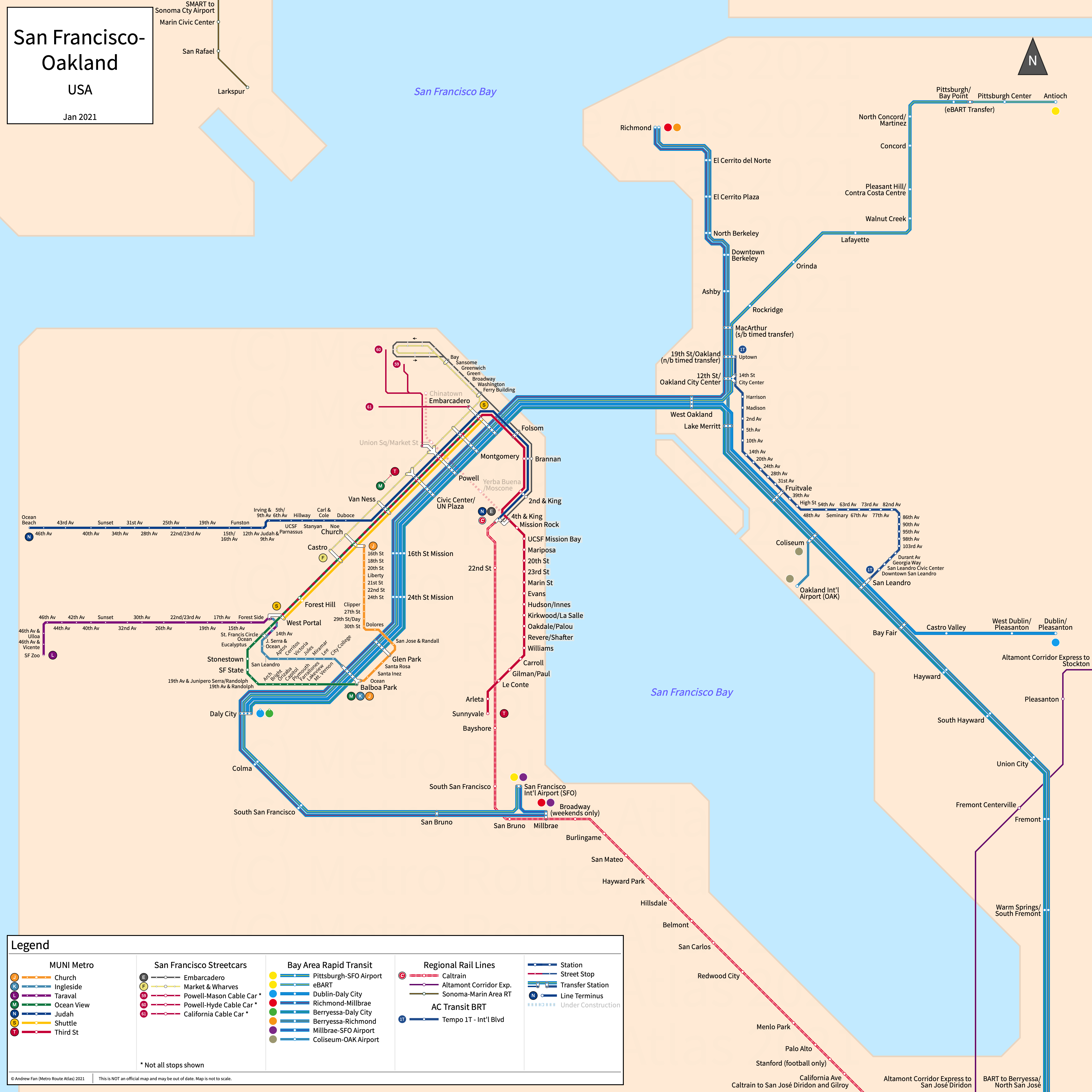
In part due to the scale of the map, the COVID outbreak, and other duties, this map took a very long time to make. It involved many difficult design decisions and while not my proudest work, remains one of the most complex networks I've ever mapped.
Most of this comes down to one simple fact - I chose to map each MUNI and BART service with separate lines. This turned Market Street into a behemoth, with four BART lines, the entirety of MUNI Metro (5 services if K and T are combined), and the F Market & Wharves all taking up a massive amount of space.
Geography was not my friend on this map and the amount of geographic distortion I needed to do to enable some form of street grid while providing enough detail on both the west and east sides of the bay was much more than I expected. I had to expand the peninsula multiple times in order to get everything to simply fit. Dense surface stops and my choice to put the names of every cross street clashed with BART's long distances between stations and the need to vertically crush the majority of the Bay Area in to a small space. As a partial casualty, I didn't add stop names for the F Market & Wharves along Market St and on the curbside shelters in the wharves.
Overall, not the most difficult map I've done - that still goes to NYC. However, a major challenge and the last until the next major metro area to cover - Toronto.
That being said, a few months later in August, MUNI Metro restructured, and I chose to shave off a line on each side of the MUNI core to provide spacing between MUNI, the F Streetcar, and BART. I think it isn't too bad.
This map was finally deprecated in April 2022 in order to split it into three separate maps for the areas served.
Project [27-0037] (2020 June - Ongoing) - MRA Indianapolis
Link: Indianapolis, Indiana, USA
Similar to the maps of other cities with simple one-line networks, Indianapolis's map was fairly simple to make. Not as simple as Fort Collins's map, but definitely one of the easier ones.
Project [27-0038] (2020 June - Ongoing) - MRA Albuquerque
Link: Albuquerque, New Mexico, USA
Similar to Fort Collins's MAX, the vast majority of ART is on a single arterial/right of way. There are two differences though - one, Central Ave is not straight west of downtown with a strange little jig, and the BRT system doesn't run on Central through downtown. In a situation that I will see more of, the two routes use two one-way streets in downtown, creating a minor mapping issue since *technically* the Downtown station is a transfer point with the New Mexico Rail Runner Express (which is a perfectly straight line on this map due to it being... pretty much a straight line through Albuquerque).
I do like how I was able to have a really nice pair of structured lines that gave a lot of form to the network, though if any extensions come to fruition, that may change.
Project [27-0039] (2020 July - Ongoing) - MRA El Paso-Juárez
Link: El Paso, Texas, USA
Link: Ciudad Juárez, Chihuahua, Mexico
I didn't actually plan to do a combined map, but unlike the horizontal straight-line border between San Diego and Tijuana, there was no way to show either El Paso or Ciudad Juárez's systems without showing a good chunk of the other city. Of course this all began the moment I decided to show Brio on the Metro Route Atlas and not just the historic streetcar.
The Metro area for El Paso and Juárez is quite tall due to the way the cities are structured, and I had to showcase the streetcar in higher detail if I wanted to show the way Brio weaves through downtown. This resulted in downtown El Paso being blown up a little bit, though on the Juárez side things were only compressed along Zaragoza, where the dimensions of the map and the angle of the avenues forced a tighter spacing if I wanted to have anything to remotely line up on a North-South axis between the two cities (Note: Things don't line up).
Overall, turned out fairly decent in my opinion. This might not be the last time I do an international map of this sort either, so it was a good introduction to my continuing work across North America.
Project [27-0040] (2020 Aug - Ongoing) - MRA Tucson
Link: Tucson, Arizona, USA
Tucson, coming straight after El Paso, is one of the many cities coming up that heavily features single track loops for its streetcar systems. Overall, it wasn't much of a challenge outside of having to fit the station names in, though it'll be interesting to see how the system changes if the north-south corridor gets built.
Project [27-0041] (2020 Aug - Ongoing) - MRA Kansas City
Link: Kansas City, Missouri, USA
Unlike many modern streetcars, most of the KC Streetcar is actually on the same street, without extra loops deviating off of the main route. This means that more time was actually spent on the river than on the line, as far as the map goes. The initial map was completed in half an hour, though it's worth noting that unlike El Paso, Kansas City's rapid bus (MAX does not even meet standards for an Arterial BRT line) didn't make it onto this site - its inclusion would have dramatically increased the complexity of the map.
Project [27-0042] (2020 Aug - Ongoing) - MRA Cincinnati
Link: Cincinnati, Ohio, USA
One of many single track loops, the Cincinnati Streetcar faces the same issues when making a map. There exist other transit plans for the region but they are all regional in comparison to the short streetcar, with its frequent stops. In the end, I fit everything in, but since I snuck the parts of the Cincinnati Subway that actually got built onto the map, the streetcar ended near the bottom instead of centered. That's still accurate given the city's geography though. Overall, not too challenging but not the easiest.
Project [27-0043] (2020 Aug - Ongoing) - MRA Oklahoma City
Link: Oklahoma City, Oklahoma, USA
Very similar to Cincinnati, except there's no half constructed subway. A standard loop streetcar with a short turn option. Not particularly challenging but it'll be interesting to see how things progress in the future should their commuter rail, rapid bus, and streetcar extensions get funded.
Project [31A] (2020 Aug) - Reykjavík (Fantasy)
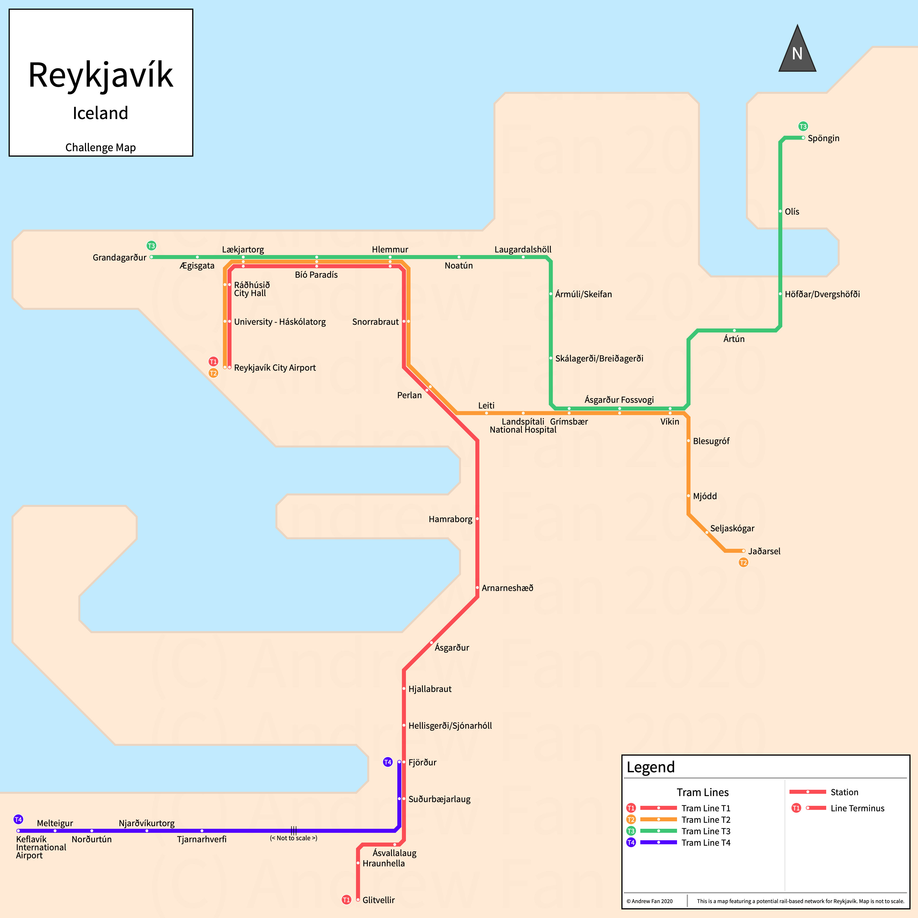
On August 23, 2020, a post on the NUMTOT Facebook page showcased an old version of the Reykjavík Bus Map and challenged map makers to create a hypothetical rail-based map for the region. At first I did a little research, not knowing the geography. I got a little too into it though and that snowballed until I spent an hour and a half (post-planning) making an actual SVG map for it. Overall, it's one of the cleanest maps I've made in a while. But then again, I designed the network. Of course I did so not knowing *anything* about the city or what corridors are highly populated. Either way, it was an interesting exercise and the official bus map made things much easier because I could copy-paste names from there instead of trying to locate the symbols that aren't easily accessible on a US keyboard.
Project [27-0044] (2020 Aug - Ongoing) - MRA Tampa
Link: Tampa, Florida, USA
A return to a coastal city where quite a bit of the coastal detail matters for geography due to the streetcar's local nature. The line itself is simple, but I originally wanted to include the entire Tampa-St. Petersburg-Clearwater metro area on one map. Naturally, that didn't happen because they are actually quite far apart and their cores are offset somewhat. Also, St. Petersburg's BRT isn't ready yet, and it's not a certain fact that I'll make a page for it. Overall, surprisingly easy to make the map, though I had previously sketched it out (including the curves of the river and the level of detail I wanted for the downtown), so it wasn't too hard to bring it to reality.
Project [27-0045] (2020 Aug - Ongoing) - MRA Little Rock
Link: Little Rock, Arkansas, USA
Another loop-based heritage streetcar line map! This one was, however, a lot more difficult than the others simply due to the fact that some of the station names are... long. "2nd Street & Rock Street/Central Arkansas Library System Main Branch" long. That and the way their part time service works (though I was prepared for that).
Overall, it came out a little cleaner than expected, though figuring out a better way to handle the long station names would have been preferable. Of course I did lock myself into this situation by showing the entire city in the map and not limiting my system map to the service area, but I still feel that doing so gives a better sense of how the services serve the city.
Project [27-0046] (2020 Aug - Ongoing) - MRA Milwaukee
Link: Milwaukee, Wisconsin, USA
The main difference with the other loop streetcars so far is that Milwaukee's has a spur that crosses over itself. This makes for an interesting visualization, though the spur has yet to open. Besides this, the map was relatively simple, as there is no commuter rail service and the arterial BRT line is still a whiles away, if I even include it.
Project [27-0047] (2020 Sept - Ongoing) - MRA Memphis
Link: Memphis, Tennessee, USA
And so we arrive at the cities in the US I deferred until the very end due to major infrastructure damage - the first of which is Memphis. Trolleys are not supposed to catch on fire, and restoration of service has been problematic. Of course they do actually plan to restore service, so it made sense to include the pre-shutdown lines on the map. I decided to use the existing 'Under Construction' designation like I did with Philadelphia for this scenario and I think it worked OK.
Another thing to note with this map was that I didn't know if the Mud Island Monorail still worked. Everything pointed to a "no it's not operational" with the official website having stripped all mentions of it. Regardless, given that Mud Island is sort of like a theme park, I didn't plan to include it to begin with.
Project [27-0048] (2020 Sept - Ongoing) - MRA Provo-Orem
Link: Provo-Orem, Utah, USA
Salt Lake City was the sixth city I made a map of. It was the first to feature a bus route. It was made during the start of the Metro Route Atlas. And it always bugged me slightly that I was featuring a line that was so far away from the others on the page that it wasn't even on the map.
But lo and behold Google Maps updated Satellite view and I took a look at the Provo-Orem area on a whim. At the time I made the Salt Lake City page, I was blindly following the ITDP's scorecard and since the corridor hadn't been rated and wasn't updated on satellite view I assumed it was just a bus line with a nice splash of paint on the buses. How wrong I was. After seeing the updated satellite view, I realized that there was probably more BRT infrastructure along this one line than there was in the entirety of Las Vegas. At the very least, there was much more than the 35X.
The map itself was not hard to make in the slightest. The UTA has an excellent geographic map and I've gotten used to handling lines that go straight but at a non-45 degree angle thanks to Chicago. And so the map was completed in about half an hour.
Project [27-0049] (2020 Sept - Ongoing) - MRA Jacksonville
Link: Jacksonville, Florida, USA
When considering Jacksonville's map, the thing that stood out the most was the water. The rivers do some interesting things, changing widths or splitting with all kinds of other coastal features. In the end, I vastly expanded downtown due to the future U2C and need to showcase downtown in more detail, and compressed the coast. This had the effect of putting the East Corridor stations equidistant from one another on the map, but it seems to work fine.
The harder part was how to handle the Southeast Corridor. Like with Chicago, it basically goes in a straight line, but not at an angle friendly to my 45 degree angles. As a result, I took some small jigs in the line and made them much more significant. I also had to do some mildly infuriating adjustments at the south end because the line doubles back to the park and ride, but I assume this is more due to how the route itself functions. I could have just used a straight line and shown them diagrammatically but this time I felt like showing the jig because it's fairly significant.
Project [27-0050] (2020 Sept - Ongoing) - MRA New Orleans
Link: New Orleans, Louisiana, USA
Massive rerouting due to the Hard Rock Hotel building collapse happening at the main bottleneck of the streetcar system and the difficulty in finding information on which stops actually existed resulted in one of the more challenging maps of the year. Bends in the river were shoved west offscreen in order to show all of the St. Charles streetcar stops (coincidentally allowing the streetcar network to be centered on the map), and somehow, the water itself wasn't challenging at all compared to the likes of Baltimore or Jacksonville.
Showing the disrupted services was hard but mainly because I had to take a different approach than I did with Memphis. This time I wanted to show both the original and revised service patterns, and my solution ended up using the paths of the original services as part of the rerouted ones. I think it worked OK, though hopefully service is restored back to normal soon.
Project [27-0051] (2020 Sept - Ongoing) - MRA Vancouver
Link: Vancouver, British Columbia, Canada
Vancouver is a welcome back to the world of oceanside cities. A downtown on a peninsula, a very wide metropolitan area, and what seems to be far too many branches of the Fraser River. The difficulty here was that although there's a nice city grid for the most part, nothing seems to actually follow it nicely, with the Millenium Line and West Coast Express making all kinds of jiggles and the Expo Line going at an awkward angle. In the end, I had to break the grid east of the Canada Line - nothing fit well otherwise. But overall, this map wasn't too bad. There aren't actually that many lines in the system and once you free yourself of the grid, it wasn't not too bad to make a usable map (though some geography must be sacrificed).
Project [27-0052] (2020 Oct - Ongoing) - MRA Calgary
Link: Calgary, Alberta, Canada
Calgary ended up being a much much harder city to map than anticipated owing to a number of challenges - like Chicago, it has a dense network of stations in the city center, and like Pittsburgh it has busways... sort of, with mixed traffic in downtown and in other locations as well. But it takes things further, with an alternate station service pattern in downtown.
Challenges essentially boiled down to three things - how to depict single directional service downtown without taking up a massive amount of map space to separate out lines, how to depict downtown MAX-CTrain interactions, and how to depict the massive differences in infrastructure quality for the MAX lines.
For the first, it was fairly straightforwards - I'd just use arrows. Typically I mark stations as (w/b only) or (e/b only), but with the space constraints in the core, that just wasn't an option. I made some more space by using a smaller font for single directional stations in the city center.
For the second, I had to sacrifice something, and the thing that was sacrificed was depiction of transfers between MAX and CTrain in the downtown core. Basically every station is a transfer if you're willing to walk a block or two, and given that so many were in a single direction only owing to every stop being in a single direction only downtown, showing the transfers would have reached a level of spaghetti that would have exceeded the mess I made with Chicago's Loop-Metra connections. So the answer was to just not show the transfers and make a note in the map key.
For the third, the issue was mainly due to Google Maps making it hard to see the actual state of the infrastructure. Busways are still under construction or nonexistent on satellite view, and whether or not you see a station on street view is dependent on when the content was taken. In the end, I realized that most stations did have some amount of infrastructure and I grudgingly let everything be considered a station and not a stop. As for the busways, they are significant infrastructure but they are so... lacking that I made the decision to, for the first time, showcase the actual busways on the map even when they were used for a tiny stretch (on the Southwest Busway for MAX Teal and Yellow). My initial concept here was to just not show it at all, but I gave in. It does make my work here less consistent with prior maps (e.g. Albuquerque, Eugene-Springfield), but I feel that it's appropriate in this case because the busway is the ONLY section of the MAX Teal and Yellow that is currently BRT standard, and it's long enough at least on Yellow to be shown.
Overall, a surprisingly challenging map. I don't know if I did it justice, but hopefully my depiction of downtown is more useful than existing maps.
Project [27-0053] (2020 Oct - Ongoing) - MRA Edmonton
Link: Edmonton, Alberta, Canada
Unlike Calgary, it was actually possible to fit stuff in the downtown because there is only a single corridor at the current time. However, with future proofing in mind, I expanded downtown quite significantly in this map, resulting in plenty of space but at the same time making some station distances near downtown much longer than they actually are. From a map perspective, this is fine though, and this ended up being a pretty simple map as a result. Maybe not my best work, but decent enough. It'll be more interesting once other lines open up though.
Project [27-0054] (2020 Oct - Ongoing) - MRA Winnipeg
Link: Winnipeg, Manitoba, Canada
After doing so many maps, the hardest part of the Winnipeg map was determining the names of local stops, as well as aligning the river to fit the entire branch to St. Norbert on the map. As usual, the official map doesn't necessarily reflect the situation on the ground, and Google is naturally inconsistent with both street view and data as far as stop names and locations (and services) are concerned. As a result, I probably missed a few stops that were on Google and not the official map... probably. The only way to find out for sure is to go and ride the line itself, after all...
Project [27-0055] (2020 Nov - Ongoing) - MRA Ottawa-Gatineau
Link: Ottawa, Ontario, Canada; Gatineau, Quebec, Canada
Ottawa and Gatineau are the first combined map since New York, and they bring along a unique set of challenges. The first and most obvious is that their transitways represent infrastructure, not services, and the transitways are not exactly... connected. Unlike Pittsburgh's South Busway, the Central, West, and Southwest Transitways in Ottawa consist of multiple disconnected fragments in between which standards fall to standard bus service, which is below the lowest standard for the Metro Route Atlas. Therefore, I made the decision to just not show the substandard portions, as this isn't a service map for the rapid bus network.
There were two more factors complicating things - the first being that the entire busway system is in partial transition to light metro and that an entire line is being closed for a significant overhaul, essentially converting a commuter rail service into a rapid transit one. For the BRT aspect, not only are the corridors disjointed, but I'm showing existing and future service in parallel (or in the case of the sub-BRT grade remainder of the East Transitway, not showing the busway at all). As for the Trillium Line, it's hard to show existing service when there... is no service. And as for the other issue? The fact that Gatineau is roughly aligned to a North-South grid while Ottawa is... not. It was the first instance of me actually rotating the North icon on on the map, even though Gatineau ended up being diagrammatic regardless.
This was a map where I was glad to have my paper draft beforehand. A welcome challenge.
Project [27-0056] (2020 Nov - Ongoing) - MRA Montréal
Link: Montréal, Quebec, Canada
From the start, I knew this was going to be a hard one due to one complicating factor - the REM. As the REM literally stretches from one side of the metropolitan area to the center, it becomes impossible to properly center the Métro, and the high density of downtown stations led me to use a larger map size than usual. In the end, this wasn't necessary... except that once it came time to insert the Pie-IX BRT, it definitely was necessary.
A map full of challenges, including multiple islands with stations on them, a need to balance Montréal against Laval due to size vs rapid transit density, and a nice way to fit all the commuter rail lines in because if I'm going to end up showing most of them due to the map dimensions, might as well shove the remainder of exo2 and exo3 into the map. This job turned out to be a lot more complex than initially anticipated, because Montréal's grid is... inconsistent. The angles also didn't work well, similar to Ottawa. And I ended up showing the exo5 detour to Gare Centrale, so that added quite a bit extra. But overall, I'm quite satisfied with the map, and it should be able to handle an extension or two no problem.
Project [27-0057] (2020 Nov - Ongoing) - MRA Kitchener-Waterloo
Link: Kitchener-Waterloo, Ontario, Canada
The map for the Waterloo Region was not particularly difficult outside of figuring out how to future-proof for the Cambridge extension. Similar to other single line maps that came before (well, technically there are two lines but there is only one station in the entire map on the Kitchener Line), the difficulty came from the minor kinks and how to handle them. In the case of ION, it's the two segments where the line splits and has stations with different names on each single directional track, but I found an approach I really liked for the Waterloo one and the Kitchener one wasn't too bad either. Overall, a simple map compared to the ones coming up next...
Project [27-0058] (2020 Dec - Ongoing) - MRA Toronto
Link: Toronto, Ontario, Canada; Markham-Vaughan, Ontario, Canada
For better or worse, as the most complex map since New York City, Toronto's map required significant advance planning, including the difficult question of choosing what to actually include. The conundrum is as follows - Toronto has suburbs to the north, east, and west, but the eastern portion has no rapid transit (yet), the northern portion goes *really far north*, and the western part is offset at a different angle. Thankfully, there's a nice clean line that can be used to separate the Peel Region, and this informed my choice to do a combined Toronto + York Region map.
For the map itself, I decided that Union was going to be smack in the middle of the map horizontally, and I decided to extend Yonge-University upwards first, using a 48-64-128 system for spacing. This actually worked very well, and after the Yonge portion was complete, I was able to add Bloor-Danforth with nice spacing, followed by Scarborough (using Yonge for spacing) and Sheppard (using Bloor-Danforth for spacing). And at first, the spacing seemed to also work for Viva Blue... until I realized I was about 128 pixels short of fitting everything on the map. As a result, I had to bite a compromise and I shifted to 48-96 for the same distances. It's unfortunate but I had enough wiggle room at the top of the map to make it not feel cramped. This did have ramifications for Go (especially the Barrie Line) but that came later.
Using Bloor-Danforth for spacing did have its fair share of problems. Toronto does not have a single street grid - depending on where you are, the grid shifts by a few degrees, and over a decent distance it has a major impact - enough that lining up stations based on the streets did not work. This was especially pronounced with Eglinton, as things refused to line up with Bloor Danforth in a nice way. It also impacted Finch West and St Clair but for those I simply gave up and used mostly equal spacing between stations.
The hardest part of the map (aside from shoving Go lines in without them looking ugly - which they were anyways since none of them follow the street grid and like to make all sorts of curves) was handling the streetcar stations. I had station names for the Harbourfront portion... until I realized that there actually weren't any except for Queens Quay. I ended up removing the labels entirely. As for St. Clair, I went on Google Street View and got station names. I had to set them at an angle but it worked OK for the most part.
Definitely a challenging project but one I'm actually quite proud of. Should be able to accommodate the Ontario Line (or whatever relief line is eventually chosen). Definitely a great way to end 2020... though Mississauga still needs a map.
Project [27-0059] (2020 Dec - Ongoing) - MRA Mississauga-Brampton
Link: Mississauga-Brampton, Ontario, Canada
After completing Toronto, the year ended with a bang with the completion of the Mississauga-Brampton map and therefore the completion of the Canada project (until London/Quebec City/Hamilton (RIP) get their rapid transit lines). This map wasn't too bad aside from having to make an unforgiving detour on the Kitchener Line due to the fact that it is at just enough of an angle to not work with my design. I did conveniently cut stations off as to not have to include Bloor-Danforth and the Toronto streetcar, but that does add more focus to the actual topic of the map.
Project [27-0060] (2021 Jan - Ongoing) - MRA Monterrey
Link: Monterrey, Nuevo León, Mexico
As I dive into Latin America for real this time, I began with one of the larger cities. Three lines, decent informational resources, and up to date images on Google Streetview that allowed me to determine the actual station names printed on the Line 3 stations (Wikipedia.es, OpenStreetMaps, Urbanrail.net, and the Transport Politic, as of the start of 2021, all had conflicting data on Line 3's stations). Juárez was mildly infuriating from a research standpoint but once the research was compiled, it wasn't too bad. Monterrey was similar - there's no website for the metro but there IS one for the BRT system, which provided a geographic map of the entire network and which was very useful for building my own. Hopefully further cities won't be too bad.
Overall, not a difficult map to set up, and I managed to get Zaragoza nice and centered.
Project [27-0061] (2021 Jan - Ongoing) - MRA Puebla
Link: Puebla, Puebla, Mexico
Moving on within Mexico, I created a map for Puebla. Puebla introduces a few interesting challenges - first, there is an incredibly station-dense eastwards corridor and a southwestwards corridor, requiring shoving a lot of stations into a small space. Second, they have through service. There's a catch though - this through service is a reverse branch that only shares a portion of the Line 2 and is branded as part of Line 3 in all materials. In short, this is more similar to the through service I did in the Theria City map than anything else I've ever encountered - it's unlike Japanese through service where the physical line takes over all service branding and unlike end-of-line through service where most or all vehicles continue onto the other line. Due to these factors, I decided to show the through service as a branch. I think it works fine, though I don't have an opportunity to visit Puebla to see if the user experience at the shared stations reflects this.
Overall, a map with much more complexity than expected, but a pretty decent job given the five or six hours of Google Maps (Satellite and Street View) I needed to put into this to figure out the through service and paired stations + other interesting service features.
Project [27-0062] (2021 Jan - Ongoing) - MRA León
Link: León, Guanajuato, Mexico
Somehow, I had an impression that León didn't really have that big of a network. Well I was very wrong. Four phases of BRT expansion have given León a BRT network covering a very good chunk of the city, and their style was having services go between corridors, resulting in 10 core services across numerous BRT and partial BRT corridors (and some street running as well).
The official map does a fairly decent job, though some issues with the official map vs satellite footage and other data resulted in me including stations that aren't on the official map for Line 2 especially. I had to figure out where I was going to draw the line with mode switching as well, which was OK in this case since León's street running portions are fairly clean. Hopefully when there is enough demand to require dedicated infrastructure, it can be built.
For this map, I used Line 4 as my 'core', spacing stops out every 64 pixels horizontally and 48 pixels on the eastern portion. When I added Line 1 next, I used 48 pixels for vertical spacing, and that trend worked quite well until I was doing Line 6 and realized that I had forgotten a station on the Line 2 only section, at which point I had to work Lines 6 and 8 in with an extra station. It looks fine, I think. There were some challenges with text locations but surprisingly, it was a fairly clean job this time.
Project [27-0063] (2021 Jan - Ongoing) - MRA Guadalajara
Link: Guadalajara, Jalisco, Mexico
The most difficult part of the Guadalajara map was the angles. None of the lines actually lock to a 45/90 grid, and so I had to do some adjustments. In addition, fitting in some text labels resulted in the city center being expanded quite a bit, but that's pretty standard for these types of maps.
Overall, an average difficulty map. Perhaps not my best work, but not my worst either. Will be interesting when the Periférico BRT opens.
Project [27-0064] (2021 Jan - Ongoing) - MRA Pachuca
Link: Pachuca, Hidalgo, Mexico
As I work my way through the smaller cities in Mexico, Pachuca stands out - it's by far the smallest city in Mexico not part of a larger metropolitan area to have a high quality bus rapid transit system and in that sense is similar to Fort Collins - one high quality line in a small city. Unlike Fort Collins however, the line is not straight, but it still follows roughly a single corridor. The map was therefore not too difficult to make.
An interesting anecdote about Pachuca is that due to its small size, I did a deep dive into every city in Mexico with a population larger than Pachuca in order to not miss any cities. Granted, I missed Guadalupe in the Monterrey area when making the page despite having explicitly written a note on it in the research document, but other cities also made their way onto the list of cities as a result.
P.S. If you're going to add a station off-line and name it after an existing station that is being renamed as a result, make sure you update your system map to reflect the name change. The Estadio Hidalgo/Central de Autobuses confusion was worse to wrap my head around than the 'feeder services only' station at Regina in Monterrey because of this.
Project [27-0065] (2021 Feb - Ongoing) - MRA Chihuahua
Link: Chihuahua, Chihuahua, Mexico
And the award for most deceivingly hard single line system goes to Chihuahua, with a convoluted system of one way operation in the downtown core, other segments of one way operation, and a city geography that screams for me to shove the legend in the top right instead of the bottom left.
In the end, I shifted things around a bit. The downtown portion doesn't align nicely, but then again it doesn't actually align nicely in reality either due to the fact that there is a differing number of blocks in between directions. Not the best work here but decent enough.
Project [27-0066] (2021 Feb - Ongoing) - MRA Querétaro
Link: Querétaro, Querétaro, Mexico
Moving forwards, I arrive at one of the stranger and more obscure BRT systems in Mexico. Two separate corridors on opposite sides of the city inaugurated at the same time, the system only works this way because both corridors are open busways. Open Busways are the hardest thing to show on my transit maps - reason being that it's not always the case that they have a predominant service. With Pittsburgh, there were predominant local services that covered the entire busway for the East and West busways, and I ended up only needing special treatment for the South Busway. With Hartford the 101 allowed me to show the entire busway as well as a brief off-busway portion. With Ottawa I only showed BRT corridors. But Querétaro is unlike any system I've done before - it fully embraces the open busway model. No service traverses the entire Eje Constitución de 1917 corridor, and very few traverse the Av. de la Luz corridor. And so showing infrastructure is the only way.
An interesting precedent for future work.
Project [27-0067] (2021 Feb - Ongoing) - MRA Mexico City
Link: Mexico City, Mexico City, Mexico
Due to the length of the retrospective, it's been moved to a blog post.
Project [27-0068] (2021 Mar - Ongoing) - MRA Acapulco
Link: Acapulco, Guerrero, Mexico
Jeez when was the last time I did a map for a coastal city? Does Toronto count as 'coastal'? Either way, the BRT in Acapulco isn't too complicated and the map took 35 minutes to make. Of course I decided to only show the trunk route, which simplified things. Either way, after the monthlong Mexico City project with lines opening during map production, it's nice to calm down a bit.
Project [27-0069] (2021 Mar - Ongoing) - MRA Guatemala City
Link: Guatemala City, Guatemala, Guatemala
Disclaimer: As I feared, the map I ended up creating was not actually accurate to the current state of things (though excluding Line 7, it was essentially accurate to the pre-COVID service patterns). The contents of the original post are contained below and mostly still stand.
I thought Portland was bad when it came to one directional service. I mean, I'm avoiding making maps of Russian tramway systems with this in mind, but... let's talk Guatemala City.
First, the obvious. The entire Transmetro network is filled with lengthy one-way routes, and they're almost never on paired streets - in some sections the different directions are up to five minutes walk apart. Add to this the fact that Google Street View coverage is negligible and Satellite view isn't exactly up to date/the best, and we basically have the worst research headache I've had when building a map on this website so far.
So let's talk about the official map. Firstly, there is no 'official' map at the current time, since the entire network is still ramping up from a complete closure during COVID and certain parts have just not reopened. This is in addition to the fact that they just opened new stations on Line 7 that were under construction. Secondly, the map that we do have is geographically incorrect, as in the places where lines cross relative to stations are completely different from what Google satellite view and the street numbers they've put on the map would suggest. Or well... it *used* to be correct. But then whoever put Line 7 in did it with the wrong offset - Line 7, which runs on Calles 4 and 9 in the city center, surrounds Parque Centenario (Calle 7) and Mercado Central (btwn Calles 5/6), not San Agustín (btwn Calles 10/11) and Correos (btwn Calles 11/12). This mess extends to Capuchinas and Colón, where it runs between the two, but the opposite than what's shown on the map - it runs north of Capuchinas (btwn Calles 9/10) and turns north directly into Colón (btwn Calles 8/9). Shifting it up would fix the mess. But alas.
And let's close with my least favorite part of this system - the obsession with having two way service on a section but only serving stations in one direction. I swear Plaza Argentina is in the middle of a two way busway but only serves one direction while buses skip the platform in the other direction. And Plaza El Amate is a similar situation, except I don't have visual confirmation on it and it's a transfer station (though service in the other direction is easily reached, so it's not too bad). Simeón Cañas is another in the category, though the station is clearly one way in this case. I've quickly grown to dislike my one way transfer icon because it's so small, but unfortunately the only other clean options are to physically show the stations on a one directional stretch (the solution I could have chosen but decided against using) or stating the direction. Oh well.
At the very least, maps are fairly smooth sailing from here on out until Guayaquil (unless there's some complicated non-Bogotá city I've missed in Colombia that has spaghetti for a BRT network).
Project [27-0070] (2021 Mar - Ongoing) - MRA Panama City
Link: Panama City, Panamá, Panama
After Guatemala City, a system with three lines and no one directional operation was a pleasant change of pace. Not much else to say here - I simplified the geography a bit but it seems to work fine.
Project [27-0071] (2021 Mar - Ongoing) - MRA Santo Domingo
Link: Santo Domingo, National District, Dominican Republic
I got to work on Santo Domingo immediately after Panama City, marking what is probably the shortest timeframe in which I've released maps for multi-line systems. And, like León in the past, Santo Domingo's map worked really well with a clean grid. Most stations were 48px apart vertically and 64px apart horizontally, and I was able to get a clean and fairly simple design. Of course future lines may complicate this, but for now I'm satisfied that I managed to get this down in under an hour.
Project [27-0072] (2021 Mar - Ongoing) - MRA Barranquilla
Link: Barranquilla, Atlántico, Colombia
I'll admit - the first time I ever took a look at Barranquilla's BRT system, I had absolutely no idea how it functioned. It turns out that the Wikipedia map just happened to make things more complicated than things were - there are three services branded differently depending on direction, with the first letter in the service denoting the terminal. It's a standard three terminal, three interlined service patterns setup that is the logical transfer-free service pattern for such a setup. And as for showing it... it's not too bad on the map either. A fairly simple project. But of course, Colombia has much more to offer as the country with some of the highest quality BRT and gondola lift systems in the world.
Project [27-0073] (2021 Mar - Ongoing) - MRA Cartagena
Link: Cartagena, Bolívar, Colombia
And so we return to complex port cities with a maze of islets and structures on the coastline. To be honest, it reminded me of Tampa when I was making the map. Either way, besides the geography, not much here was complicated - a single east-west line.
Project [27-0074] (2021 Mar - Ongoing) - MRA Manizales
Link: Manizales, Caldas, Colombia
The only way this map could have been simpler would have been if the network was one service in a straight line.
Project [27-0075] (2021 Mar - Ongoing) - MRA Cali
Link: Cali, Valle del Cauca, Colombia
As I go deep into Latin America BRT territory, I face my second proper 'trunk lines vs services' dilemma. Up to this point, Barranquilla was the first time I had made a map where I mapped infrastructure with through running and where it actually mattered how I presented it (commuter rail networks where everything collapses into a single line don't really count), but with Cali (and future cities), the presentation is key due to a complex network. In the end, I chose to not show terminal bullets (or bullets in general) except for at the terminals where service ends. Hopefully it works, because Bogotá is coming up...
Project [27-0076] (2021 Apr - Ongoing) - MRA Medellín
Link: Medellín, Antioquia, Colombia
As one of the most prominent cities in the world for public transportation, Medellín's geography is uniquely suited for high capacity transportation along a primary axis, yet it has so many other corridors that the map actually ended up being slightly more complicated than expected. That being said, although there may be a lot of individual lines and services, the gondolas only have a few stations each and so there are fewer stations than one might expect.
The difficulties in this map was futureproofing and research. Futureproofing for when they add another rail line on the east side of the river, and research due to the ongoing upgrade of Line 2 to BRT standard and the maligned slowly-progressing Line 3. Overall though, there weren't too many surprises making the map.
Project [27-0077] (2021 Apr - Ongoing) - MRA Bucaramanga
Link: Bucaramanga, Santander, Colombia
A one line network where geography had to be arranged quite a bit in order to fit the line in. However, it's only a single line, so not too much work. Although I doubt there will be any additional lines anytime soon, Giron and the city of Bucaramanga itself should have some space on the map.
Project [27-0078] (2021 Apr - Ongoing) - MRA Bogotá
Link: Bogotá, Capital District, Colombia
My aim with Bogotá was to improve on what I did with Cali, showing all the possible operational patterns that were served by BRT services with the intention of making a service map afterwards. Little did I know that with a network this complex... the more interesting problems escalated quickly.
There was one main difficulty point - there are a lot of corridors, and they interact with other corridors in a variety of ways. Thankfully, Richard Archambault (@richardmtl) sent me an incredibly complex diagram of the actual trunk services, and I ended up having to redo half of the junctions I had already mapped due to inaccuracies on my part (I relied on an overview map that showed some of the trunk corridor through patterns but not all of them, and it was out of date). It's no surprise that navigating the system is *hard*, and the fact that TransMilenio provides a few 'easy routes' (Rutas fáciles) is very much necessary for anyone trying to use the network to not be turned away by the sheer complexity. In particular, there were a few routes that used one path onto a corridor, then used a reversing loop part of the way down (looking at you, C73/J73).
Overall it was a very fairly lengthy and complex but otherwise rewarding experience. Shoving the Metro in was its own set of worms (and I'm not sure how I'll put the tram-train lines in) but those will be further worked on as more information is available (i.e. once construction picks up).
Project [27-0079] (2021 Apr - Ongoing) - MRA Pereira
Link: Pereira, Risaralda, Colombia
Finally, a multiline system in Colombia that uses services instead of zones! This map was... fairly simple, though due to station label spacing, the streets don't line up. I originally attached the addresses, as the official map does (albeit inconsistently) but in the end I opted for the cleaner option and removed them.
Project [27-0080] (2021 May - Ongoing) - MRA Maracaibo
Link: Maracaibo, Zulia, Venezuela
It's not often that you come across a city that has abandoned a rapid transit line after opening it, but Maracaibo is one of those cities. Even with TransMaracaibo, the most difficult part of the map was the coastline. Like Cincinnati, I've given Maracaibo the abandoned treatment, with the line still there but mostly faded out.
Project [27-0081] (2021 May - Ongoing) - MRA Valencia
Link: Valencia, Carabobo, Venezuela
No real rivers, no real water bodies, no administrative borders, and only one line with 9 stations in a straight north south direction. Both Fort Collins and Manizales took about 13 minutes each from template to finish. Valencia took 6.
Project [27-0082] (2021 May - Ongoing) - MRA Mérida
Link: Mérida, Mérida, Venezuela
Similar to Bucaramanga, Mérida has one line that goes from the downtown core down a valley to the distant suburbs. In addition, they had plans to extend to the northeast. How to handle this? In the end, I left buffer space in the city center area but did try to prevent it from looking too off-center vertically. It turned out OK, I think. Centering it would have been an option, but that would have put downtown in the far northeast corner of the map, so I decided against it.
Project [TTD-006] (2021 May - 2021 June) - Avonby
Link: Avonby, OpenTTD
A fully diagrammatic geography-ignoring map only showing trunk and not feeder services. That was the goal, and that was what I got. Compared to prior maps, not showing local bus routes made it much easier to make the map and to be honest, allowed me to do whatever routing I wanted for them. 10/10 would use this approach again for future OpenTTD maps.
Project [27-0083] (2021 May - Ongoing) - MRA Caracas; Los Teques
Link: Caracas, Capital District, Venezuela; Los Teques, Miranda, Venezuela
It's my second time making a map of Caracas, but this time I decided that I'd do two things differently that would make life harder for me: first, show the two 'Lines' of the Los Teques Metro separately to be consistent with the handling of Caracas Metro Lines 4 and 5, and also use the same bullet format for both Caracas and Los Teques's metro. Naturally, this caused some issues, and hopefully the legend makes it clearer, given that I didn't do what I did for Valencia...
Project [27-0084] (2021 May - Ongoing) - MRA Barquisimeto
Link: Barquisimeto, Lara, Venezuela
And the award for most difficult research phase goes to Barquisimeto, Venezuela. Website dead, Wikipedia content made by a single person (and contradicting official documents), official documents contradicting one another (sigh), and new lines getting announced without a strip map for me to have station names.
It's also a partially open system, which makes things *very complicated*. There are feeder services on this network that have more of their route on busways than the actual BRT branded routes, and Line 6 does this indescribable U shaped loop without connecting directly with itself. But thankfully, I did León, Mexico before this city, and so I was able to directly pull from there - a similar network with heavily interlined trunk routes with both on-busway and off-busway portions. As a result, I made the decision to not show ANY of the non-busway stops (and stops they are, because many of them are actually less substantial than MUNI's 'paint on the utility pole' stops, which sometimes at least have a shelter or wheelchair ramp). Overall, it's not my best work but given the limited information I had, it's... OK, I suppose.
Project [27-0085] (2021 June - Ongoing) - MRA Maracay
Link: Maracay, Aragua, Venezuela
...It's basically just a straight line.
Project [27-0086] (2021 June - Ongoing) - MRA Barcelona-Puerto La Cruz
Link: Barcelona-Puerto La Cruz, Anzoátegui, Venezuela
TransAnzoátegui is one of those systems where it's hard to explain what parts are good and bad. It has dedicated contraflow with lot of mixed traffic sections where the contraflow lanes swap sides, but also manages to have a surprisingly large number of single directional stations. And so I had to bring the 'Station Served in a Single Direction Only' legend item back in. However, it has both stations physically on separate roads and therefore served in a single direction only as well as two way roads where there's a station only on one side. Oh well. I hope it's clear enough on the map...
Project [TTD-007] (2021 June - 2021 July) - Sudean
Link: Sudean, OpenTTD
Back to my standard MRA style but with some catches, I was in territory that reminded me of some of my nicer maps. Not going to lie, I really do like the way German urban rail transit maps work, and I decided that 90 degree angles could be prioritized.
There are two things of note - the map was designed with the zonal system in mind (hence different colors and contrast), and I had no idea that I would never expand south. In fact, I didn't close out the empty south section of the map until just before publication.
Definitely a slightly cleaner project than the others I've worked on for OpenTTD. No more feeders on map!
Project [27-0087] (2021 July - Ongoing) - MRA Guayaquil
Link: Guayaquil, Guayas, Ecuador
There are two problems I encountered when making the map for Guayaquil. These are Troncal 4, and water. First, water. Guayaquil is on a river delta, and besides the rivers themselves, there is a tangle of waterways that I decided were just not worth shoving into the map. The amount of effort required to put them in would have caused more problems than it was worth. And this leads to the other problem - Troncal 4. For some strange reason, they decided to make the line take a huge one way loop through downtown, sharing parts of existing BRT ROW but not where it made sense. The route has both branches run straight through a major transfer station without stopping, meaning that travelers connecting with Troncal 3 can only do so in one direction within fare control. The need to include Troncal 4's stations meant that downtown had to be widened significantly - to the point that geography was distorted so badly that it was impacting the geography elsewhere on the map. Even trying to make a diagrammatic map for Guayaquil would be a difficult task due to Troncal 4.
In the end though, the map did get done...
Project [27-0088] (2021 July - Ongoing) - MRA Cuenca
Link: Cuenca, Azuay, Ecuador
Cuenca's tramway is fairly standard, with single street operation in the downtown core. Aside from trying to shove station names into the map and how to handle the rivers (Tomebamba and Yanuncay are shown; Tarqui was dropped), the map was pretty standard.
Project [27-0089] (2021 August - Ongoing) - MRA Quito
Link: Quito, Pichincha, Ecuador
Quito is a long city. It also boasts a horribly unintegrated bus rapid transit system, has no semblance of a street grid due to the topography, and it's not really possible to align the entire network to any given axis. Add to this the fact that the Metro is the first real step at integrating the system and you get... a mess.
Surprisingly, downtown is actually the only hard part of the map, and I did that first, somehow having enough space on both the north and south. But the real issue was the metro alignment relative to the BRT stations and lines. I ended up consulting GIS data and the diagrams for the entire alignment of the line. It's a fabulous goal, connecting the entire city via metro, but the metro winds around so horribly on the official map that I had to come up with something better.
For the first time in a while, I'm actually quite proud of my work with a large city like Quito. I had to make some sacrifices, but since it was impossible to make a coherent geographic map anyways, this didn't bother me too much. I did have to use smaller font sizes for BRT stations though (major transfer stations were left in the large font). All in all, a fairly decent job.
Project [27-0090] (2021 August - Ongoing) - MRA Lima
Link: Lima, Lima Province, Peru
Finally a map where I can do a more diagrammatic approach without geography screaming at me. It think it turned out quite nice - no real challenges other than station spacing on Line 2. Of course Line 3 being added will probably uglify things due to it sharing a similar corridor to El Metropolitano, but... hmm.
Project [27-0091] (2021 August - Ongoing) - MRA La Paz-El Alto
Link: La Paz-El Alto, La Paz, Bolivia
Like Manizales before it, La Paz's network is exclusively gondola lifts. Due to spacing, I decided to take some liberties - 16 pixels at transfers, 64 between stations diagonally, 80 horizontally. This resulted in a surprisingly clean map, which I like. Took more work than it should have, but when there are so many lines, I suppose that's inevitable.
Project [27-0092] (2021 August - Ongoing) - MRA Valparaíso-Viña del Mar
Link: Valparaíso-Viña del Mar, Valparaíso, Chile
Simple maps are good. This system has only one line. Of course I'm not mapping the funiculars, but they are on a very different scale than the rail line. RIP Metro Valparaíso branding - you will be missed.
Project [TTD-Multi-001] (2021 August - 2021 September) - Stanbridge
Link: Stanbridge, OpenTTD
Aiming minimalist for ease of time, transfer icons were once again abolished, and so were route colors, terminal bullets, and other time-intensive map components. This allowed for rapid prototyping and development, and would later contribute to my solution for the Sacramento Single Direction Transfer Panic (TM). Map size is large due to covering entire map (we only used about a third).
Project [27-0093] (2021 September - Ongoing) - MRA Santiago
Link: Santiago, Santiago, Chile
My approach with Santiago was simple - use Bío Bío as my reference point, and expand outward in uniform directions. 6 West, 4 South, 2 North, 5 West, 2 South, 3A, 3 North, so on, and so forth. I formed a square out of Lines 1, 2, 3, and 5, and used consistent spacing for Line 1 to guide the western part of the map, while Line 2 south of the square guided the southern part of the amp. Space was left for BRT corridors and for through service on the commuter lines. The river was deprioritized entirely until all lines were added.
Due to the planning, pretty much everything except for Baquedano lined up perfectly, and I was able to get some nice symmetry and spacing across the map. Of course, I had to jiggle things around when I actually added the BRT corridors, but that was less of an issue. Speaking of which, it's nearly impossible to set station locations for the BRT in Santiago since it's an open network, but by choosing to avoid showing stops entirely, I was actually able to combine the approach together with my new transfer station system in a way that worked fairly well. I did shrink the thickness of the lines despite them all being on some level of Basic or higher BRT, but Line 1 is also red and I wanted the mode hierarchy to be more pronounced on this map.
Overall, I'm quite proud of this map, and it's one of the best ones I've made in a while - mostly giving in to diagrammatic approaches made things work out pretty well, I think. I need to combat the urge to make things more geographically accurate if it will overcomplicate things for the person using the map, after all.
Project [27-0094] (2021 September - Ongoing) - MRA Mendoza
Link: Mendoza, Mendoza, Argentina
No major rivers aside from a creek and a single line meant that the map for Mendoza was speedrun in 12 minutes. Faster than Fort Collins and Manizales, but slower than Valencia.
Project [TTD-Multi-002] (2021 September - 2021 September) - Stanburg Bay
Link: Stanburg Bay, OpenTTD
Similar to Multi-001, except interlined services are grouped together. No new innovations on this map.
Project [27-0095] (2021 September - Ongoing) - MRA Córdoba
Link: Córdoba, Córdoba, Argentina
Another fairly simple map. The river makes a lot of twists and turns but there is no rapid transit of any kind inside the city center, so although I enlarged it a bit, there's not much to show on this map yet. Perhaps that will change in the coming years.
Project [27-0096] (2021 September - Ongoing) - MRA Santa Fe
Link: Santa Fe, Santa Fe, Argentina
Similar to Córdoba in scale and difficulty. Unfortunately there isn't much to say here.
Project [27-0097] (2021 October - Ongoing) - MRA Neuquén
Link: Neuquén, Neuquén, Argentina
Neuquén in on a similar scale to the systems in Córdoba and Santa Fe. Except it has more infrastructure, and a meaningful commuter rail line, unlike the one in Córdoba that has so few departures per day that it makes American commuter rail systems look frequent. Not much to speak about when it comes to the map.
Project [TTD-Multi-004] (2021 October - 2021 October) - Pluthwaite
Link: Pluthwaite, OpenTTD
Similar to Multi-002, where simplicity and ease of map generation was the primary focus. No new innovations on this map.
Project [27-0098] (2021 November - Ongoing) - MRA Buenos Aires
Link: Buenos Aires, Autonomous City of Buenos Aires, Argentina
Buenos Aires has the most complex and robust rapid transit, commuter rail, and bus rapid transit in the Spanish speaking Americas aside from potentially Mexico City. It comes as no surprise then that the Buenos Aires map was one of the hardest to make - especially because unlike Mexico City, there is no integrated map currently existing. Now, such a large map forced tradeoffs, and some design choices had to be made in order to display everything.
First, the general overview. The Subte is the core of Buenos Aires, and so I applied consistent spacing to the horizontal lines of the Subte (A/B) first, then used positioning to align Line B using the diagonal Line D. This formed the core part of the map. From this, everything else emerged. And in fact, I took the decision to completely forego geography if needed outside of the core. This was influenced by two decisions - first, seeing an integrated rail map of Buenos Aires and deciding that, yes, I did have enough space to fit all the commuter lines. The original plan was to only show the portions of the commuter network that were necessary to position the Metrobús lines, but in the end I included everything, with the exception of the La Plata branch (done on purpose with the intention of possibly creating a page on the MRA for La Plata in the future should they get bus rapid transit or upgrade their urban rail service to a proper frequent trunk. As a result of extra space and my decisions, I was able to successfully include almost all of the commuter rail network in the map.
There were two more design choices I needed to make, however. First, Metrobús lines. In Santiago, it was impossible to get single points for stations on a map due to the way the bus rapid transit corridors are so integrated into the regular bus network. Buenos Aires is similar but the corridors have clear infrastructure, meaning that in all cases except for Metrobús Norte, it is possible to associate a single set of platforms with a single station name, and vice versa.
Part of the way through the design process I decided to include station names for Metrobús after realizing that station names for 9 de Julio and del Bajo, with stations each block, indeed fit on the map. And so this trend continued... except for Metrobús Norte. So, the thing about Metrobús Norte is that there is a single directional station on each block, but these are grouped together - 2 in one direction, 2 in the other direction, etc but where each platform has a different name. This was... impossible to fit into the map. In the end, I used stop icons specifically for this use case, and then thanked the people who designed the Metrobús La Matanza for not pulling something like this and instead assigning a single name to multiple platforms.
The other design choice I needed to make was treatment of the administrative boundary. It is actually a significant divide that geographically separates major parts of the network. I ended up including it for the first time in a while. However, due to Metrobús Sur and the Premetro's stop spacing this resulted in horrible station spacing warping on the Roca line's Haedo branch, which in the map goes in the completely opposite direction in order to navigate around the expanded space taken up by the Premetro and Metrobús Sur. It's not the most important change since nothing important currently connects to it, but new Metrobús Corridors may introduce some... headaches in the future.
Overall, Buenos Aires was the hardest map I've done in a long time. I didn't get the same satisfaction with the map work that I got with Santiago's clean design, but I'm proud of this work, which is much more that can be said of some of my prior works (cough cough San Francisco-Oakland).
Project [27-0099] (2021 November - Ongoing) - MRA Criciúma
Link: Criciúma, Santa Catarina, Brazil
As the smallest city in Brazil to have a bus rapid transit line, Criciúma is the Fort Collins/Pachuca of Brazil, pulling far above its weight. Its single line runs down the main thoroughfare of the city, and serves three major terminals. The map itself was pretty simple. The research that Criciúma forced however was not, as Criciúma is the 142nd largest city in Brazil, and that meant researching BRT presence in well over a hundred cities. Turns out it's mostly unique.
Project [27-0100] (2021 December - Ongoing) - MRA Curitiba
Link: Curitiba, Paraná, Brazil
Thankfully, when compared to a city like Bogotá, Curitiba's BRT network is... far more legible. By chosing to focus on where the core routes go, it vastly simplified the map... but some decisions still needed to be made. In particular, there were two issues - one, where exactly does Circular Sur join Boqueirão, and two, how to handle transfers vs through operation. For the former, I just chose what the official map uses. For the latter... it's complicated. I used the base services here as well to determine transfers and through operation. If two services share a single station but otherwise don't through operate, as with Circular Sur/Verde and at Praça E.C., I didn't combine them into a single line/station and instead had two lines with a transfer. Terminals got an transfer if no services through-run. As a result, I didn't show transfers for Circular Sur, and in fact the service patterns aren't even on the map.
It's a weird hybrid between showing infrastructure and services, but I think it works fine for giving an overview for the network as a whole.
Project [27-0101] (2021 December - Ongoing) - MRA Porto Alegre
Link: Porto Alegre, Rio Grande do Sul, Brazil
Porto Alegre forced me to make choices, which was frustrating yet refreshing. There are a few things to note - first, the metropolitan area is very vertical, and the metro is very suburban in nature. Therefore, the map ended up being very long. On the flip side, compressing the metro does not work well in the core, since multiple BRT-Lite lines come together in the core and after deciding that the lower half of the map was too empty, I made the decision to actually put these onto the map.
I did have to redo quite a bit of work in order to make room for the III Perimetral, which still didn't fit very well. But that was nothing compared to the real kicker for this map - station names. NONE of the BRT or BRT-Lite stations have names on them. Google has station names, but only for the stations operated by a specific company. If that company doesn't serve the lines, all there is is an address on the road. And so not only are my station names entirely unreliable, I don't even have them for a few lines.
Overall, putting the extra time in means that the map is probably better futureproofed for if/when the next metro line gets built or if they actually decide to upgrade their BRT-Lite to actual BRT but... who knows how long that will be.
Project [27-0102] (2021 December - Ongoing) - MRA Brasília
Link: Brasília, Federal District, Brazil
After Porto Alegre, missing-station-name syndrome is a lot less worrisome. More worrisome is whether or not I should have even included EPTG in the first place (Moovit suggests there's still service but... I don't actually know), and whether I should have shown the parts of Expresso DF Sul off-busway, including under construction portions. Either way, I've shown what I have and I think it's fine - we'll see if any more stuff gets built.
Project [27-0103] (2022 January - Ongoing) - MRA Goiânia
Link: Goiânia, Goiás, Brazil
To be frank, the existing line for Goiânia was simple to map aside from the Rua 7/8 debacle. However, for the under construction North-South axis... well... let's just say that the official documentation is a little shaky, and it's hard to determine which stations are actually stations. Oh well. Once it opens it should be clearer. My treatment in the map though does try to show that the existing network is centered on the city center, not the center of the metropolitan area. Overall, not too hard of map, but I say that knowing that I'll be mapping both Rio and São Paulo soon, so...
Project [27-0104] (2022 January - Ongoing) - MRA Uberaba
Link: Uberaba, Minas Gerais, Brazil
Uberaba was one of those cases where going with a corridor approach vs a service approach made me scratch my head a little. There are three BRT corridors with their own names, numbering systems, and color designations, but they are served by two services. Each service covers two corridors, with 100 doing a weird jiggle as part of its through operations. I could have shown just the services, but all of the system branding is done on a corridor basis. So I went with that for the page... but not for the map, where I went with the service approach. I could have done something similar in Curitiba, but Linha Verde (and busway sections not served by trunk routes) complicated that. I think the approach I took here works well.
Project [27-0105] (2022 January - Ongoing) - MRA Uberlândia
Link: Uberlândia, Minas Gerais, Brazil
It was shocking how little drama there was when mapping Uberlândia. Two through services lines, and that's it. I had to adjust the lines to fit (city center is not at the center of the map) but I think the map balance isn't too off. There is a third corridor that's BRT-Lite at the moment, but I did not include it for the time being - maybe if they upgrade it in the future.
Project [32-001] (2022 January) - LMP Akron OH
Link: Akron, Ohio, USA
Akron was the first map in the MRA's Light Metro Project and so I was designing it together with the template I'd be using for all future cities. I decided that dark mode would be nice, and used Chelicerant Town's color scheme, but I also wanted two other things: thicker lines and curves. The former meant a different spacing standard than the standard MRA map, and the latter meant trigonometry. But not much, since the only angle I ever need to use is 45 degrees (lol).
Overall, the map wasn't too hard, other than trying to make a nice diagrammatic map. And yes, diagrammatic - I do research, corridor planning, a geographic map, and the diagrammatic map in that order, and there is always both a diagrammatic map and a geographic map. So unlike the MRA, I'm completely free to make a map that has little to no restriction when it comes to geography. In Akron's case, the regional line has some adjustments to make it fit, and I ignore the rivers completely. Overall, a pretty clean start and one I can be proud of!
Project [27-0106] (2022 January - Ongoing) - MRA Belo Horizonte
Link: Belo Horizonte, Minas Gerais, Brazil
Belo has shockingly low amount of mass transit infrastructure for a city its size. But that aside, the main issue with this map was spacing between the metro and MOVE BRT, as well as handling the numerous curves on the metro. I ended up using MOVE stations for spacing, which meant that the downtown is actually pretty low. Though that being said, the city does look that way. Not much space for western lines on this map, but I can always shift as necessary to fit things.
One thing I did have to think about was the MOVE stations outside the two corridors. It doesn't show up on the current official map, but station (but not ROW) infrastructure continues up past Vilarinho up until Terminal Morro Alto. I decided to not bother with this... only learning that some of the stations were actually vandalized due to not being served during the pandemic. It's unfortunate, especially since slapping some dedicated ROW is pretty easy on that corridor.
Project [32-002] (2022 January) - LMP Wichita KS
Link: Wichita, Kansas, USA
At one point I worried that this project wouldn't be challenging. Well, it was refreshing to almost want to reach out for a spreadsheet to determine which corridors to choose for this project - when a city has a lot of corridors and there are many different alternatives for the 'fill in the remainder of your budget' portion, that can happen.
From a map structure perspective, Akron prepared me for Wichita, but not for how horribly unbalanced the map was going to be, with the long airport branch taking up a lot of space. A lot of things got pushed to the right side of the map, and I barely had any space left. Thankfully I did some adjustments and everything fit nicely. In addition, I had to use semicircles again for 'technically a transfer' stations, which was refreshing. Overall, it was harder than I thought and I'm grateful for the practice.
Project [32-003] (2022 January) - LMP Chattanooga TN
Link: Chattanooga, Tennessee, USA
I finally had a situation where I didn't do any regional lines, and where I actually added in the river! My main gripes about Chattanooga focus on the lines themselves rather than the map - but the map itself went very smoothly. To be honest, there wasn't anything particularly challenging this time - it's a simple network.
Project [32-004] (2022 January) - LMP Port St. Lucie FL
Link: Port St. Lucie, Florida, USA
The network map is simple. The process for developing the network was not. And coincidentally, this is the very first time I didn't need to adjust the default river location on my template. Hooray!
Project [32-005] (2022 January) - LMP Savannah GA
Link: Savannah, Georgia, USA
One Line. One River. Fitting some of the stations in was a little problematic but it worked out in the end, even if the curves aren't exactly where they are geographically.
Project [32-006] (2022 February) - LMP Stockton CA
Link: Stockton, California, USA
Stockton and the layout of lines I had provided a very nice opportunity for me to center things horizontally, using Line 2 as the midline and spacing Line 1 and the regional rail out. For this reason, Line 3 was the first line to be added to the map, with Line 1 coming next to give the map form. I did have a hard time with the key and fitting the regional lines in though, so the key got... adjusted, while I compressed the regional lines at the bottom. Still enough space for a line to Lodi!
Project [27-107] (2022 February - Ongoing) - MRA Rio de Janeiro; Niterói
Link: Rio de Janeiro, Rio de Janeiro, Brazil; Niterói, Rio de Janeiro, Brazil
The first real question was how to frame the map. In particular, the east bay question. I had roughly two choices - design from the east to west and ignore Niterói entirely, or start from the west and move east, including Niterói if I had space. I chose the latter.
The Santa Cruz Line provides the core east-west rail line, but TransOeste is entirely in control here because of how many stations it has. I opted to bend geography in order to fit as many in as possible, with the hope that I would be able to fit Niterói in. Turns out that I barely had enough.
Besides working from west to east and needing to twist the BRT lines to fit (TransOlímpica got distorted a lot due to the way I handled the Santa Cruz line and TransOeste; TransCarioca looking nice was deprioritized over having the Belford Roxo and Metro 2 lines straight), the main issue was handling the VLT system. Lots of one way action, in a dense urban core. In the end it ended up being blown up quite a bit but due to the way the lines converge in downtown, the geographical constraints weren't that bad.
Overall, this was a hard map (and São Paulo is not going to be easier), but in the end it's not my shabbiest work.
Project [32-007] (2022 March) - LMP Boise ID
Link: Boise, Idaho, USA
To be blunt, the preparatory work for Boise was far harder than the actual map, given that retrieval of the diagrammatic map involved software crashes constantly due to how many water features are in Boise on OpenStreetMaps. But once that was done, things were cleaner... or so I thought.
My system for curves in maps does not like parallel curved lines at all.
As the plague that has chased me relentlessly throughout my time making maps, I didn't have enough space to do a proper grid with Boise due to the distance to Nampa and my insistence on keeping the map a square. As a result, I had to use parallel diagonals with parallel curves on the shared section of Lines 2 and 3. This was a fairly difficult process but it looks... acceptable. Which is good enough.
I also decided to omit the river due to the number of station labels that would have overlapped it.
Overall, a bit more challenging than I had initially anticipated, but I'm satisfied with the result.
P.S. - The fact that Ten Mile Rd is six miles away from Five Mile Rd disappoints me yet also amuses me greatly.
Project [27-108] (2022 March - Ongoing) - MRA Santos-São Vicente
Link: Santos-São Vicente, São Paulo, Brazil
To be honest, the water was the most challenging part of the map since I planned on making it mostly a straight line from the get go. Should be future proofed for Line 2 if it ever gets built.
Project [27-109] (2022 March - Ongoing) - MRA Sorocaba
Link: Sorocaba, São Paulo, Brazil
Sorocaba's network is very simple, for the most part, and by not showing the non-BRT downtown portions and the river, the map ended up taking about 20 minutes to make. It is off-balance, but this is on purpose due to future lines being futureproofed in (the western corridor may come to fruition in the near future). Overall, for the last 'easy' map for a while, it was decidedly uneventful to make.
Project [32-008] (2022 March) - LMP Anchorage AK
Link: Anchorage, Alaska, USA
Anchorage's map was mostly simple - after a few similar maps things tend to get more standardized and the process becomes simpler. The map got done without too many hassles - about one hour including export time.
Project [27-110] (2022 April - Ongoing) - MRA Oakland
Link: Oakland, California, USA
This was my first time remaking a map (or rather, taking my worst map, and splitting it apart). The original had the west bay at MUNI scale (stops every other block) and the rest of the map at BART scale (stations that are often 1-5 km apart). The side effect of this was that Oakland's BRT was horribly distorted on the original, making turns and twists that didn't even exist.
This map fixes those problems by prioritizing Tempo, giving it a straight parallel line next to the BART trunk where the BART station spacing is entirely dependent on Tempo's station locations. It's a lot more elegant, and collapsing BART down to a single line removes a lot of the mess - both mapmaking-wise and visually.
What's even better is that I was still able to fit the northeastern parts of the BART network onto the map. This is fantastic and means that any new projects in the area should fit in the existing space without too much of a rework. Or even with a rework, given that it took surprisingly little time for me to accomplish my goals here. Overall, I'm much more proud of this map than the original. As for the San Francisco side... that might take a bit of work.
Project [TTD-008] (2022 Apr - 2022 Apr) - Fuerte Olimpo
Link: Fuerte Olimpo, OpenTTD
In another exercise of attempting to do more than necessary, this map aimed to show only infrastructure... while also having primary services. And so the majority of the service was relegated to a line with branches at stations meant to show where feeder services left the infrastructure. Overall the map is about as confusing as the network is. Which is probably acceptable given it is another experiment.
It's attempts like this that make one realize how much work it would take to make a usable physical map of TransMilenio's service patterns...
Project [27-111] (2022 April - Ongoing) - MRA San Francisco Bay Area
Link: San Francisco Bay Area, USA
Finally something new - in this case, my first Metro Area map. Unlike the normal maps I make, these will be made with the intention of compressing massive areas into a single map with only regional transit, and so are mostly diagrammatic and will show regional service patterns a little better.
First thing's first - this was a LOT better than my original as far as BART was concerned. In the old map, BART dominated but not in a good way - stretching the map around BART was ugly, especially as far as San Francisco was concerned with the hideous curve for Daly City and the geographic stretching making other parts look awful. Early on, I made the decision to not show local transit at all on the regional maps, and so those problems were cleared entirely.
This same process allowed me to space the east bay's BART stations equally (which was great), and also allowed me to have the Orange Line cross over the Yellow and Blue lines in a perfectly symmetrical, incredibly satisfying way. Mmm. My favorite part of this map.
The map was also built futureproofed, with space for two BART infill stations, space to adjust in case BART's San José extension actually occurs, space for Atherton in case they decide that they do in fact want Caltrain service again, and a SMART infill stop. Somehow I had enough space for ACE all the way to Stockton, and Valley Link should fit as well. SMART extensions will not fit but that's just the reality imposed by having to fit the legend somewhere (which pushes up everything else).
Overall, a pretty decent map. A lot better than the old one, though I still need to redo San Francisco - probably from scratch.
Project [TTD-009] (2022 Apr - 2022 Apr) - Vinkelgast
Link: Vinkelgast, OpenTTD
Hey, look here! A map trying to combine local and regional services onto one map! This sounds awfully familiar given the exact project I'm working on right now!
There are no innovations on this map. Unfortunately, the OpenTTD maps have become more of a standardized thing now... which is mainly for iteration speed, after all.
Project [27-112] (2022 April - Ongoing) - MRA San Francisco
Link: San Francisco, California, USA
Oh what a relief it is to look at the final product. The original combined San Francisco-Oakland map wrecked Oakland far more than it did San Francisco, but it still committed multiple atrocities, all relating to BART. In particular, the four services made the Market St core so wide it interfered with geographic placement, and the way I handled Daly City and the areas south of San Francisco were horrid. Now that I am compressing BART down and don't need to bother with anything south of Daly City (especially its interaction with Caltrain), the map looks much, much cleaner, and gave me a surprising amount of space for K Ingleside and M Ocean View. I was able to fit in both inbound and outbound cross streets, and didn't need to rely on angled text. In addition, there's a LOT more space to work with in general.
I'm a lot more proud of this one than the original, and I'll try and remember the lessons learned as the San Francisco Bay Area rework project comes to a close.
Project [32-009] (2022 May) - LMP Fort Myers-Cape Coral FL
Link: Fort Myers-Cape Coral, Florida, USA
Diagrammatic maps to the rescue with this one. The regional line was fairly simple to squeeze into the remaining space after the light metro routes were added. The hardest part was getting the water to work well - I needed the river to work in such a way that it turned near Downtown Fort Myers while also allowing Line 1 to cross it, and I think the end result looks pretty decent. Not everything needs to be 45 degrees!
Project [27-113] (2022 July - Ongoing) - MRA São Paulo
Link: São Paulo, São Paulo, Brazil
Ah, São Paulo. I knew in advance I'd need a lot of space, and I planned from the very start that the SPTrans corridors would be treated like they were in Santiago. Starting with Line 1, I spaced things out with Ana Rosa at the center of the map, and used 80 pixels between metro horizontally/vertically, 64 diagonally, and 48/32 for BRT. In the end, things turned out mostly fine. Line 15 was stretched on its inner sections but compressed on its outer sections, and Line 8 + EMTU Itapevi were horribly compressed and turned in order to fit, but those were the only portions where I was explicitly forced to defy geography significantly.
But even the best plans fall apart. When I was adding the last corridor before the SPTrans ones - the ABC corridor, I discovered that São Bernardo do Campo had their own BRT-Lite network. And then, after doing those, Santo André. AND Guarulhos (though theirs doesn't have station names at all). In the end, five additional corridors were added to the map at the time I thought I was almost complete. But in the end, it got done, and there was a lot of space. Not too cramped for the most part. And honestly, one of my better maps. We'll see how it holds up when Line 19 gets threaded through downtown.
Project [27-114] (2022 July - Ongoing) - MRA Belém
Link: Belém, Pará, Brazil
It's nice to have a mostly drama-free (cough why are there two Bosque stations 400m from one another cough) line map for once. Overall, a sub one hour map, even including water features and the São Brás loop.
Project [27-115] (2022 July - Ongoing) - MRA Fortaleza
Link: Fortaleza, Ceará, Brazil
This is probably the most transit construction paralyzed city I've seen since Caracas, with infill stations, a new line, and a new branch all planned... but not going anywhere. Anyways, there wasn't much of a challenge here - the most interesting thing was showing the section of alternating single directional stations with different names, having to use diagonal text. But... that's about it. One more city done.
Project [27-116] (2022 August - Ongoing) - MRA Salvador
Link: Salvador, Bahia, Brazil
Peninsula surrounded with water, with a monorail going over an inlet, no street grid due to rough terrain, and awkward station spacing. Salvador's tough. However, perhaps surprisingly, I didn't need to change the water features much after putting them onto the map, thanks to some planning, and everything fit, to my surprise. Line 1 required a lot of adjustment but I think the map turned out acceptable.
Project [32-010] (2022 August) - LMP Portland ME
Link: Portland, Maine, USA
This map is a case of city geography being very tempting for me to just... make symmetric. Water features were laid first, and lines were added in later. Due to deciding to take a southern regional line but not the northern one, the city center isn't exactly centered on the map but overall, a few spacing issues aside, it looks pretty decent.
Project [27-117] (2022 August - Ongoing) - MRA Recife
Link: Recife, Pernambuco, Brazil
We close out the last metro system in Brazil with another map with quite a bit of water, though in the end I just adjusted it as necessary afterwards to fit in the stations. I initially wanted to align the central core midway through the map but in the end that didn't happen. Still, I'm surprised everything fit. Overall a decent project.
Project [27-118] (2022 September - Ongoing) - MRA Teresina
Link: Teresina, Piauí, Brazil
I recall Teresina being the scariest city in Brazil when I first began thinking about Brazil for the Metro Route Atlas. I didn't understand the corridors at the time, as I was still in the mentality of closed trunk and trunk-feeder busways from the US, Mexico, and Colombia. Argentina and Chile smashed those barriers for me though, and after dealing with literally every other system in Brazil prior to Teresina, Teresina's network is actually disappointing. Not just because literally all of the infrastructure is physically disconnected... sigh.
Handling the multiple street grids, the tilt of the entire city (it isn't aligned north-south), and managing the river were the hardest parts of the map. But afterwards... it was fine. Maybe not the fanciest work, but pretty decent, if I say so myself.
Project [27-119] (2022 September - Ongoing) - MRA Manaus
Link: Manaus, Amazonas, Brazil
Two main corridors, with some under construction portions. Aside from the many curves and changes in avenue, it's a pretty simple system to map out. I didn't include the detail past the river since there isn't much there, so the final map ended up being simpler than my draft.
Project [27-120] (2022 September - Ongoing) - MRA Cochabamba
Link: Cochabamba, Cochabamba, Bolivia
It's been a while since I did a map for a Spanish speaking country, and I made plenty of typos when making the page for Cochabamba. Thankfully there were alignments on YouTube and station names on the official Facebook that I was able to cross reference, so I was able to get pretty much everything I needed with only a few hours of research. This is one of the few times neither Urbanrail.net nor Wikipedia were useful, as both used station names and alignments that do not correspond to what was actually built (I believe they reference a much older plan for the network - the stations have since changed and the plan for the central station was completely redone).
Overall, not a hard map, though we'll see how it ages.
Project [32-011] (2022 September) - LMP Columbia SC
Link: Columbia, South Carolina, USA
To be blunt, this map was one of the simpler ones I've done. Using the river and Line 1 for vertical orientation and aligning the east-west trunk line along the midpoint of the map allowed for a mostly drama-free mapping experience. Still a good exercise though.
Project [27-121] (2022 October - Ongoing) - MRA São José dos Campos
Link: São José dos Campos, São Paulo, Brazil
A small city planning a big network, but where neither streetview nor satellite view provide up to date information on where the northern extension's stations go (or even what the alignment is). Current map is therefore a little unbalanced to take the northeastern extension into account. I've done this before in Argentina, so it's no biggie, but hopefully I'll learn where the new stations are and will be able to put them onto the map.
Project [32-012] (2022 November) - LMP Gulfport-Biloxi MS
Link: Gulfport-Biloxi, Mississippi, USA
This was actually one of the first metropolitan areas I thought of when beginning work on this project. It's perfectly linear for the most part, and has a rail line down the core. I actually began work on it about a month and a half began making the page, but procrastinated on it.
The main challenge was fitting in all the stations as well the water features. I ended up using a smaller font size to fit everything in. Overall it didn't end up too bad, albeit cramped.
Project [27-122] (2023 February - Ongoing) - MRA Perth
Link: Perth, Western Australia, Australia
Is this seriously the first time I've had an S-Train network on the MRA?
Aside from adjusting the Swan River a dozen times, the Perth map was uneventful. I initially tried to do a compressed square size map, but it would have been very cramped and entirely diagrammatic in order to fit the long north-south stretching rail network in, especially due to the Thornlie-Cockburn Link putting a transfer point in. I think it's a fairly decent work.
Project [27-123] (2023 March - Ongoing) - MRA Adelaide
Link: Adelaide, South Australia, Australia
Adelaide is like Perth in that it's a 'when to stop scaling properly' kind of situation, except that in Adelaide's case, the Gawler Line has a LOT of stations, and just... keeps on going. But aside from that and having to decide on whether or not to straighten the Glenelg Tram, the map was fairly routine to make. No crazy stuff here. The big question was how to handle the fact that there are both rush hour and weekend only services - normally I don't even show weekend only service, but in Adelaide there's a line branch that's only served on the weekends, so... yeah. There will be more of this, since it's a very Australian (and Spanish?) thing to have weekend only rail service to showgrounds and the like.
Project [27-124] (2023 June - Ongoing) - MRA Campinas
Link: Campinas, São Paulo, Brazil
I put this one off because it was too messy. In the end, I was right. It took another 14 months after I did my initial research before a single line began full day bidirectional service.
From the start, I knew that there were two main challenges for this map. First, the original VLT (light rail) alignment was... curvy. Very curvy. I just straightened out part of it and let the other bit zigzag. The second issue was scale. Campinas is one thing, but the BRT-Lite corridors that connect to it are truly intercity, and go far to the northwest. I ended up using the Not to Scale standard I created in my Reykjavík map, together with a lot of boxes. Hopefully the positioning makes it clear how the geography works a bit better.
In the end, by waiting for stuff to open, this map became easier... funny.
Project [27-125] (2023 June - Ongoing) - MRA Honolulu
Link: Honolulu, Hawai, USA
After having handled so many coastal cities, simplifying the geographic complexity of Pearl Harbor and the area between the airport and downtown was the only real challenge of this map. That being said, this is the first formal dual language station setup on the MRA, and it will not be the last. A fairly simple map overall.
Project [27-126] (2023 August - Ongoing) - MRA Ogden
Link: Ogden, Utah, USA
Given that the river is not very significant, this map didn't take too long to set up. This was helped by official geographic maps and prior work done for the Wasatch Front, in particular Provo and Orem's map.
Project [33a] (2023 October) - Challenge: Niamey, Niger
Link: Niamey, Niger
This map was made for a challenge. See the dedicated page for more information on route selection and the map design process.
Project [27-127] (2023 December - Ongoing) - MRA Melbourne
Link: Melbourne, Victoria, Australia
The largest tram network in the world. What a worthy challenge. But of course, the question then becomes how to show the network, and whether or not to show the stops.
For how to handle the trams, I effectively used a 'trunk' setup, where in the CBD and near-CBD areas, lines would be grouped down into a single trunk line, and if multiple trunk lines served a near-in corridor, the lines would be shown separately for easier navigation. The clearest examples of this are where I separated 58 (West Coburg - Toorak) in all cases as it shared very short portions with other lines, and where I separated Bourke and Collins St services on the west side of the CBD. Notably, I chose to split the lines terminating from Melbourne University from those going past, as it also aids in readability. Outside the CBD and near-in areas, I did not perform this similar treatment (excluding the St Kilda Beach section), though the sections shared by 16/64 (south of Malvern station) and 48/109 (between Victoria Gardens and Kew) probably would have benefitted from the treatment. I also separated the city circle line for legibility.
I'm not entirely sure that my solution is the 'best' but as part of my goal was to be resilient to service pattern changes that may happen in the future, I think it works. For now. Speaking of which, whether or not to show tram stops was a significant decision and choosing to do so added weeks to the map development time. In the final map, the tram stops (non-accessible) are not all shown, but they're all mapped. Fitting the tram station names was probably the biggest challenge of this map aside from defining the tram routings - I used a smaller font size that I've never used for city maps.
This was also the first map where I had a significant rollout of service pattern indicators mid-route, something I haven't really had to do very much before. I did this for Toronto, for example, but that network is far smaller and much less complex. For a network like Melbourne's however, it is a necessity, and the way I did things this time will definitely influence how I do things in the future for other complex tram networks.
Overall, this was a long, stressful, but rewarding project, and I expect that it will significantly impact other projects moving forwards. From new standards for tram networks to directly influencing a rework of my Miami map (extended station icons) to handling of non-accessible tram stops, this is definitely a defining project.
Oh, and sorry about the river. I was NOT about to weave that through.
Project [27-128] (2024 February - Ongoing) - MRA Canberra
Link: Canberra, Australian Capital Territory, Australia
Sandwiched geographically (for historical reasons) and in my execution order between Melbourne and Sydney, the two giants of Australian public transportation, being able to complete a map in 30 minutes is a nice change. I'll have a similar sigh of relief when I do Newcastle after Sydney. Nothing special to mention about the map this time, other than the fact that the light rail line barely goes into the center of the city, so the dimensions of the map are a bit weird.
Project [27-129] (2024 May - Ongoing) - MRA Santiago de los Caballeros
Link: Santiago de los Caballeros, Santiago, Dominican Republic
Santiago de los Caballeros was fairly simple to map out, as I opted to not include the river. There are four phases of construction and opening, and everything is weighted towards the southwest of the urban area, but other than that there were no major difficulties.
Project [27-130] (2024 May - Ongoing) - MRA Mérida
Link: Mérida, Yucatán, Mexico
Welcome to Mérida, the newest bus rapid transit network in Mexico since it leapfrogged over Torreón's paralyzed-trying-to-find-an-operator network. Built incredibly rapidly by replacing the old railroad with bus rapid transit and (unfortunately) making copious use of mixed traffic or curbside running, it opened in several phases and as of map creation, is still expanding to its planned initial size. This was one of those systems I put off for a while because getting good information was difficult but it turns out that once you get over the fact that Line 1 is 903 and Line 3 is 901, and they use both designations at the same time, route information isn't too bad.
Still, this is a curious network. None of the stations are proper stations yet, for one - no station names, no off-board payment, and no level boarding. The first service to open is an express route that only runs when the Tren Maya is scheduled to arrive or depart. The second one is the actual BRT service, even if the eastern part isn't up to par. And the third is just a regular bus that happens to use a bit of busway. All of this, plus one way loops, made this map more challenging than expected. Still, it's now complete and is probably the only up to date map of the network as of writing...
Project [27-131] (2024 September - Ongoing) - MRA Madison
Link: Madison, Wisconsin, USA
One Line. How hard can it be? Well, depends. First, on if the two other BRTish services are to be shown (and if so, how much), and second, on if the separate platforms are shown separately, such as when some station pairs are multiple blocks apart.
I opted to show the cores of the B and F routes (I tried adding the non-BRT sections to the map and it looked ugly). But for F, not showing that it stops separately at both Capitol Square stations is kinda bad. But with three lines entering from one end and two exiting from the other, it kinda became impossible to make the square look perfectly nice (the official map does a pretty decent job though).
In short, around 90% of the work on this map was spent on the square. I think my rendition isn't awful. Not great either though. Still, serviceable. A decent challenge.
Project [27-132] (2024 December - Ongoing) - MRA Sydney
Link: Sydney, New South Wales, Australia
With a downtown defined by water features and a multi-centric network layout, Sydney was a city whose map was challenging in a way unlike most others. On one hand, the downtown area of Sydney needed to be expanded significantly on the map to fit the sheer number of services entering and looping around it, and on the other hand, the main line west was not straight and Parramatta was its own hub, with its own bus rapid transit and light rail networks that required more space.
In what was probably a first, I completely ignored all water features until the very end, and focused exclusively on the lines, not even bothering to come up with a paper draft first. In the end... it came out fine. The station spacing for the metro's northwest section was not pleasant due to the Richmond branch going quite far out, and the T4 and T8 service patterns were a headache, but I think I did a decent job.
Project [27-133] (2025 July - Ongoing) - MRA Campeche
Link: Campeche, Campeche, Mexico
Aside from the typically long station distances outside of downtown, the excruciatingly long detour to get to the station that is the reason why this project exists in the first place (why is it in the complete middle of nowhere), the fact that the vehicle's battery charge doesn't last a single round trip, the fact that they are considering 30 minute headways to be good, and whatever is going on with the airport terminal spur, the Campeche Light Rail is a typical magnetically guided busway.
...the map wasn't a problem to make in the slightest. It's no Mérida.
Project [27-134] (2025 November - Ongoing) - MRA Feira de Santana
Link: Feira de Santana, Bahia, Brazil
Feira is geographically quite simple, with a circle defining the city. I used that and... just made the spoke at a slight angle straight for the purposes of the map.
The research for the map probably took around 20-30x longer than the actual creation of the map.
Project [27-135] (2025 December - Ongoing) - MRA Newcastle
Link: Newcastle, New South Wales, Australia
To be honest, I spent more time on figuring out if I wanted to include the non-tram rail lines than actually making the map. The city isn't too large so most of the work was on the water features.
Project [27-136] (2025 December - Ongoing) - MRA Brisbane
Link: Brisbane, Queensland, Australia
Brisbane's main challenges are as follows: A very, very windy river in downtown, an extraordinarily dense amount of infrequent lines in downtown, and busways with overlaid services where those services don't serve all the busway stops. My solution for the last one was to separate busways from the Metro services visually (there are more differences than you might think) while also expanding the downtown significantly to allow it to fit everything. And I think it works, though we'll see how well it fares with more metro lines and new service patterns brought about once Cross River Rail opens.
Project [27-137] (2025 December - Ongoing) - MRA Gold Coast
Link: Gold Coast, Queensland, Australia
Like Brisbane to the north, the Gold Coast is very long, but given that it essentially only has two lines which both go north-south, it was easier to map. In this case, I opted to show the stations south of Beenleigh on the map, and opted not to show the water features within the city limits. In addition, since Stage 4 of the light rail has been axed for now, I didn't bother provisioning for it or the Gold Coast Airport extension of the regional rail. If those plans get revived, it's not too difficult to put them on the map, after all.
Project [27-138] (2025 December - Ongoing) - MRA Auckland
Link: Auckland, Auckland, New Zealand
Located on an S-shaped isthmus with countless peninsulas, Auckland's geography is quite interesting, and that was the main challenge of the map. In the end, the network itself is simple enough and will likely not get too complex in the future. I didn't futureproof northern extensions of the Northern Busway but there's plenty of space to work with. I also opted to shove the southern portion of the Southern Line in, like I often do for outer lines. But overall, not too bad of a project.
Project [27-139] (2025 December - Ongoing) - MRA Wellington
Link: Wellington, Wellington, New Zealand
Wellington's rail network is interesting because the city itself is small, mountainous, and on a peninsula, with most of the rail network not actually inside the city. This forces the actual city to be shoved into the corner. But somehow I managed to make everything fit.
Project [27-141] (2026 April - Ongoing) - MRA Uruapan
Link: Uruapan, Michoacán, Mexico
With a single line made up of straight segments, and a general landscape without major water features, this was one of the simplest maps made recently.