Atlanta, Georgia, USA
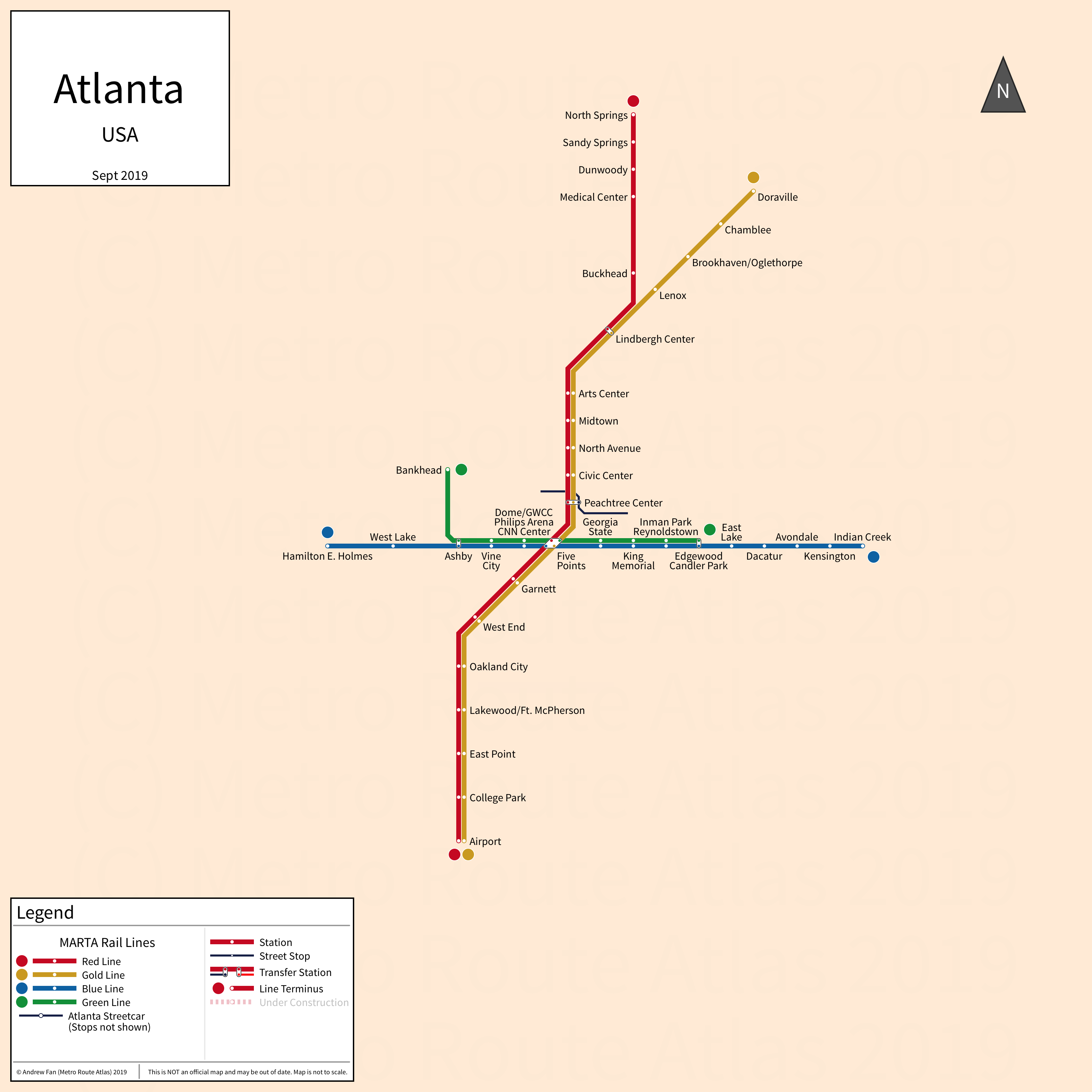
Table of Contents
Overview - Atlanta
Located at the foothills of the Appalachian Mountains, Atlanta is the capital of and the largest city by population in Georgia. It has approximately 511,000 inhabitants in the city proper as of 2023. The Atlanta metropolitan area (Atlanta-Sandy Springs-Roswell) comprised 6,307,261 residents as of the 2023 US Census Bureau Estimate.
Atlanta's rapid transit network consists of four metro services. It also has a modern streetcar service running in a loop downtown and an arterial BRT service.
MARTA Rail
Opened 1979, the Metropolitan Atlanta Rapid Transit Authority's heavy rail rapid transit network consists of four metro services that serve the city of Atlanta, Georgia and the surrounding suburbs.
East-West Lines (Blue and Green)
The Blue Line (or East-West Line until 2009) is a metro service on an East-West alignment, running from Hamilton E. Holmes in the west to Indian Creek in the east via Five Points in downtown Atlanta. It serves 15 stations.
The Green Line (or Proctor Creek Line until 2009) is a metro service on an East-West alignment, running from Bankhead in the west to Edgewood/Candler Park in the east via Five Points in downtown Atlanta. It serves 9 stations. On weekends, it terminates at King Memorial instead of Edgewood/Candler Park.
The Blue and Green lines share most of their track.
The East-West trunk line was opened in June 1979 and the last extension to the line was in Sept 1993, when the Blue Line was extended to Indian Creek. The Blue and Green Lines are owned and operated by MARTA.
| Service | M-F Midday | M-F Rush | Sat. | Sun. | Notes |
|---|---|---|---|---|---|
| Blue | 12' | 10' | 20' | 20' | |
| Green | 12' | 10' | 20' | 20' |
Schedules -- Last Updated: Apr 21, 2026
North-South Lines (Gold and Red)
The Gold Line (or Northeast-South Line until 2009) is a metro service on a Northeast-South alignment, running from Doraville in the northeast to Hartsfield-Jackson Atlanta International Airport in the south via Peachtree Center and Five Points in downtown Atlanta. It serves 18 stations.
The Red Line (or North-South Line until 2009) is a metro service on a North-South alignment, running from North Springs in the north to Hartsfield-Jackson Atlanta International Airport in the south via Peachtree Center and Five Points in downtown Atlanta. It serves 19 stations.
The Gold and Red lines share most of their track.
The North-South trunk line was opened in April 1981. The branch that formed the Red Line opened in 1996. The last extension to the line was in 2000, when the Red Line was extended to North Springs. The Gold and Red Lines are owned and operated by MARTA.
| Service | M-F Midday | M-F Rush | Sat. | Sun. | Notes |
|---|---|---|---|---|---|
| Gold | 12' | 10' | 20' | 20' | |
| Red | 12' | 10' | 20' | 20' |
Schedules -- Last Updated: Apr 21, 2026
MARTA Rapid
Opened 2026, the Metropolitan Atlanta Rapid Transit Authority's bus rapid transit network consists of an arterial BRT service that serves the city of Atlanta, Georgia and its inner suburbs.
MARTA Rapid A-Line
The MARTA Rapid A-Line is an arterial BRT service on a North-South alignment, running from Five Points in the north to Carver in the south. It serves 10 stations of which five are served in a single directional loop.
The MARTA Rapid A-Line was opened in April 2026 without stations outside of the downtown loop. The MARTA Rapid A-Line is operated by MARTA.
| Service | M-F Midday | M-F Rush | Sat. | Sun. | Notes |
|---|---|---|---|---|---|
| Rapid A | 12' | 12' | 12' | 12' |
Schedules -- Last Updated: Apr 21, 2026
Atlanta Streetcar
Atlanta Streetcar
The Atlanta Streetcar is a 4.3 km modern streetcar service on a loop alignment, serving 12 stops in downtown Atlanta.
The Atlanta Streetcar was opened in December 2014. The Atlanta Streetcar is owned by the City of Atlanta and is operated by MARTA.
| Service | M-F Midday | M-F Rush | Sat. | Sun. | Notes |
|---|---|---|---|---|---|
| Streetcar | 15' | 15' | 15' | 15' |
Schedules -- Last Updated: Apr 21, 2026
References & Helpful Links
Atlanta Streetcar at Wikipedia
Official Website for MARTA: Metropolitan Atlanta Rapid Transit Authority
Maps
Official System Map - MARTA [PDF] [Last Accessed April 21, 2026]
Other Sources
Asset Notes
Rail line colors taken from October 2018 official MARTA system map. Rapid A-Line color taken from Rapid A-Line page.