Melbourne, Victoria, Australia
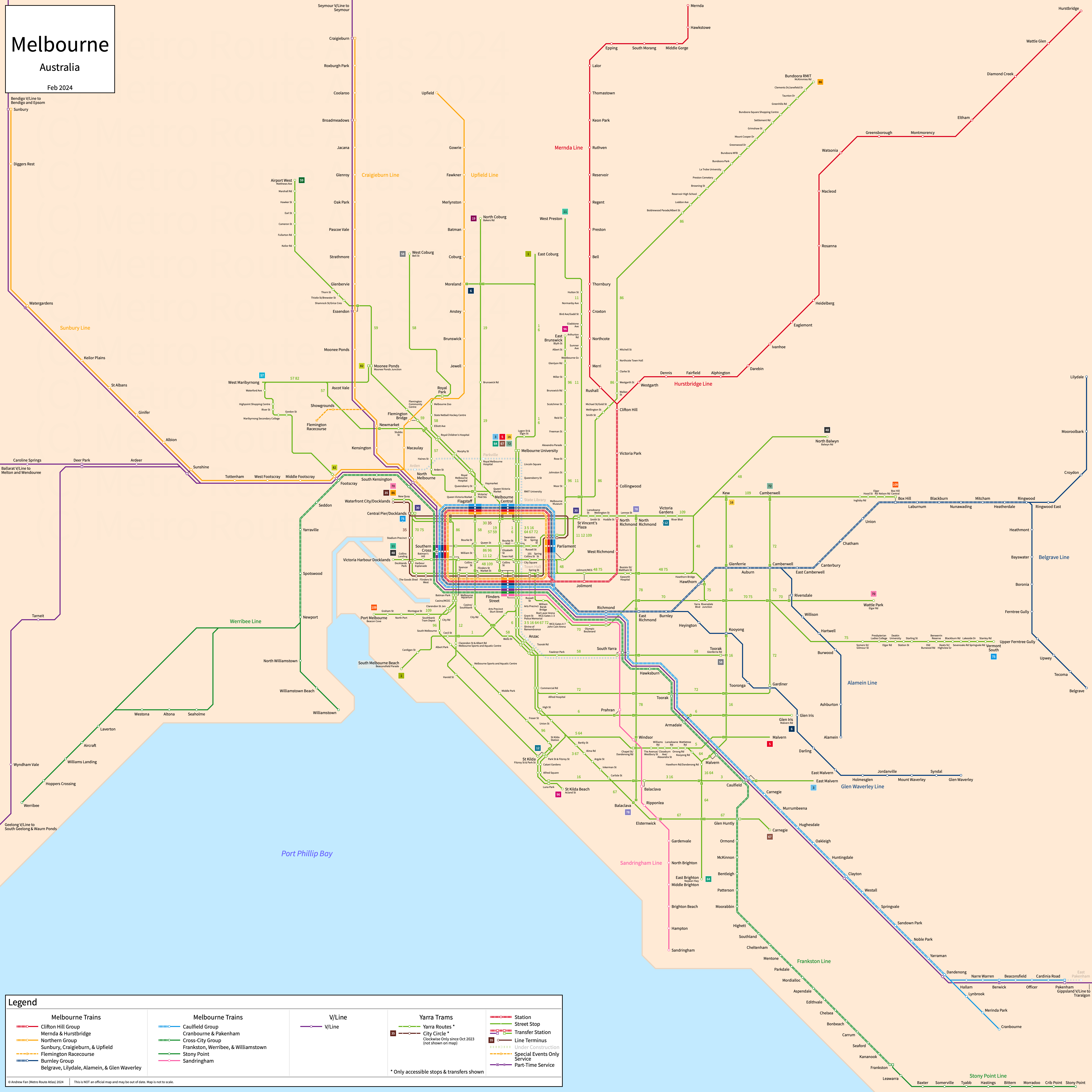
Table of Contents
Overview - Melbourne
Located on Port Phillip Bay, Melbourne is the capital of Victoria and the second largest city by population in Australia. It has approximately 4,818,000 inhabitants in the city proper as of 2021. The Melbourne metropolitan area (Melbourne GCCSA) comprised 4,917,750 residents as of the 2021 Australian Bureau of Statistics Estimate.
Melbounre's rapid transit network consists of six groupings of S-Train/Commuter Rail lines. It also has 24 tram services (two of which partially operate as light rail) and a commuter rail network.
Melbourne Trains
Split from the VicRail in 1983, the suburban rail network of Melbourne Trains consists of 16 service groupings of S-Train/Commuter Rail lines, grouped into 6 trunk lines, that serve the city of Melbourne, Victoria and the surrounding suburbs. All lines here are operated by Metro Trains Melbourne. On our strip maps, whether or not a tram has a transfer or not is dependent on whether a tram icon appears on the official strip map for the line.
City Loop & Flinders Street Viaduct
The City Loop and the Flinders Street Viaduct form the core of the Melbourne Trains network, with the viaduct connecting the Southern Cross and Flinders Street terminals and the City Loop serving three stations on an underground alignment. Together, these form a loop around the Melbourne Central Business District. Excluding the Cross-City and Metro Tunnel Groups, all groups run through these in a single direction, with dedicated single direction tracks for each group. Due to this infrastructure being shared between different lines and groups, and directional service patterns changing for different lines throughout the day, we are separating out this shared infrastructure here to simplify strip maps for the other lines.
The Flinders Street Viaduct opened in December 1894 and the City Loop opened in 1985.
Werribee, Williamstown, and Sandringham Lines (Cross-City Group)
The Werribee Line is a S-Train service on an East-West alignment. It runs from Werribee in the west to Flinders Street in the east, serving 17 stations. Between Laverton and Newport, there is a bypass track that allows some services to run express. The Williamstown Line is a S-Train service on a Southwest-Northeast alignment. It runs from the Williamstown in the southwest to Flinders Street in the northeast, serving 12 stations. The Sandringham Line is a regional rail service on a North-South alignment. It runs from Flinders St in the north to Sandringham in the south, serving 14 stations. While branded as a single Cross-City Group, there is no through service at Flinders Street yet. Through service is planned for late 2026.
The Werribee Line was opened in October 1857 and the last expansion to the line was the opening of Williams Landing in April 2013. The Williamstown Line was opened in January 1859 and the last expansion to the line was the opening of Seddon in December 1906. The two lines were rerouted into the City Loop starting February 2026, with through service to the Frankston Line ending at that time. The Sandringham Line was opened in December 1859 and the last expansion to the line was the opening of Ripponlea in May 1912.
| Service | M-F Midday | M-F Rush | Sat. | Sun. | Notes |
|---|---|---|---|---|---|
| Werribee | 20' | See Timetable | 20' | 20' | |
| Williamstown | 20' | See Timetable | 20' | 20' | |
| Sandringham | 15' | 7.5' | 20' | 20' |
Schedules -- Last Updated: Feb 15, 2026
Cranbourne, Pakenham, and Sunbury Lines (Metro Tunnel Group)
The Cranbourne Line is a S-Train service on a Northwest-Southeast alignment. It runs from the Metro Tunnel in the northwest to Cranbourne in the southeast, serving 17 stations up to Malvern. The Pakenham Line is a S-Train service on a Northwest-Southeast alignment. It runs from the Metro Tunnel in the northwest to East Pakenham in the southeast, serving 22 stations up to Malvern. The Sunbury Line is a S-Train service on a Northwest-Southeast alignment. It runs from Sunbury and Watergardens in the northwest to the Metro Tunnel in the southeast, serving 12 stations up to Footscray. The three lines are linked by the Metro Tunnel, which serves 5 stations in between Footscray and Malvern.
The Cranbourne Line was opened in October 1888 and the last expansion to the line was the opening of Lynbrook in April 2012. The Pakenham Line was opened in October 1877 and the last expansion to the line was the opening of the Metro Tunnel in November 2025. The Sunbury Line was opened in February 1859 and the last expansion to the line was the opening of the Metro Tunnel in November 2025. The Metro Tunnel itself opened for full service in February 2026.
| Service | M-F Midday | M-F Rush | Sat. | Sun. | Notes |
|---|---|---|---|---|---|
| Sunbury | 10' | See Timetable | 10' | 10' | *1 |
| Cranbourne | 20' | See Timetable | 20' | 20' | |
| Pakenham | 20' | See Timetable | 20' | 20' |
Schedules -- Last Updated: Feb 15, 2026
*1 - Only every other train goes past Watergardens to Sunbury
Craigieburn, Upfield, and Flemington Racecourse Lines (Northern Group)
The Craigieburn Line is a S-Train service on a North-South alignment. It runs from Craigieburn in the north to the City Loop in the south, serving 21 stations. The Upfield Line is a S-Train service on a North-South alignment. It runs from Upfield in the north to the City Loop in the south, serving 19 stations. The Flemington Racecourse Branch branches off of the Craigieburn Line and serves two stations on special events only, and is not shown on the map above. All lines share track up to North Melbourne and form the Northern Group.
The Craigieburn Line was opened in November 1860 and the last expansion to the line was the opening of Coolaroo in June 2010. The Upfield Line was opened in 1884. It was cut back from Somerton in 1961.
| Service | M-F Midday | M-F Rush | Sat. | Sun. | Notes |
|---|---|---|---|---|---|
| Craigieburn | 20' | See Timetable | 20' | 20' | |
| Upfield | 20' | See Timetable | 20' | 20' |
Schedules -- Last Updated: Feb 15, 2026
Mernda and Hurstbridge Lines (Clifton Hill Group)
The Mernda (formerly South Morang) Line is a S-Train service on a North-South alignment. It runs from the City Loop in the south to Mernda in the north, serving 29 stations. The Hurstbridge Line is a S-Train/commuter rail service on a Northeast-Southwest alignment. It runs from the City Loop in the southwest to Macleod, Greensborough, Eltham, and Hurstbridge in the northeast, serving 28 stations. Both lines share track up to Clifton Hill and form the Clifton Hill Group.
The Mernda Line was opened in October 1889 and the last extension to the line was to Mernda in August 2018. The Hurstbridge Line was opened in 1888 and the last extension to the line was to Hurstbridge in 1912.
| Service | M-F Midday | M-F Rush | Sat. | Sun. | Notes |
|---|---|---|---|---|---|
| Mernda | 20' | See Timetable | 20' | 20' | |
| Hurstbridge | 20' | See Timetable | 20' | 20' | *1 |
Schedules -- Last Updated: Feb 15, 2026
*1 - See timetables for which trains continue past Macleod. On Weekends, trains alternate between Eltham and Hurstbridge as terminals
Lilydale, Belgrave, Alamein, and Glen Waverley Lines (Burnley Group)
The Alamein Line is a S-Train service on a Northwest-Southeast alignment. It runs from the City Loop in the northwest to Alamein in the southeast, serving 18 stations. The Glen Waverley Line is a S-Train service on an East-West alignment. It runs from the City Loop in the west to Glen Waverley in the east, serving 20 stations. The Lilydale Line is a commuter rail service on an East-West alignment. It runs from the City Loop in the west to Lilydale in the east, serving 27 stations. The Belgrave Line is a commuter rail service on an East-West alignment. It runs from the City Loop in the west to Belgrave in the east, serving 31 stations. All lines share track up to Burnley and form the Burnley Group, with most trains sharing track to Camberwell and the Lilydale/Belgrave lines sharing track up to Ringwood.
The Alamein Line was opened in July 1898 and the last extension to the line was to Alamein in June 1948. The Glen Waverley Line was opened in March 1890 and the last extension to the line was to Glen Waverley in May 1930. The Lilydale Line was opened in December 1882 and the last expansion to the line was the opening of Union in May 2023. The Belgrave Line was opened in December 1889 and the last expansion to the line was the opening of Union in May 2023.
| Service | M-F Midday | M-F Rush | Sat. | Sun. | Notes |
|---|---|---|---|---|---|
| Alamein | 15-20' | See Timetable | 20' | 20' | |
| Glen Waverley | 15' | See Timetable | 20' | 20' | |
| Belgrave | 30' | See Timetable | 20' | 20' | |
| Lilydale | 30' | See Timetable | 20' | 20' |
Schedules -- Last Updated: Feb 15, 2026
Frankston Line (Caulfield Group)
The Frankston Line is a S-Train service on a Northwest-Southeast alignment. It runs from the City Loop in the northwest to Frankston in the southeast, serving 32 stations.
The Frankston Line was opened in December 1881 and the last expansion to the line was the opening of Southland in November 2017. It was rerouted into the City Loop starting February 2026, with through service to the Werribee and Williamstown Lines ending at that time.
| Service | M-F Midday | M-F Rush | Sat. | Sun. | Notes |
|---|---|---|---|---|---|
| Frankston | 10' | See Timetable | 10-20' | 10-20' |
Schedules -- Last Updated: Feb 15, 2026
Stony Point Line
The Stony Point Line is a commuter rail service on an East-West alignment. It runs from Frankston in the west to Stony Point in the east
The Stony Point Line was opened in October 1888 and the last expansion to the line was the opening of Morradoo in November 1960.
| Service | M-F Midday | M-F Rush | Sat. | Sun. | Notes |
|---|---|---|---|---|---|
| Stony Point | See Timetable | See Timetable | See Timetable | See Timetable |
Schedules -- Last Updated: Dec 02, 2023
Yarra Trams
Opened 1884 with electrification starting in 1906, Yarra Trans consists of 24 tram services (two of which partially operate as light rail) that serve the city of Melbourne, Victoria and the surrounding suburbs. Due to sheer scale of the world's largest legacy tram network, strip maps and timetable information are omitted from this website. Refer to PTV Timetables for timetables and Yarra Trams for stop listings. All tram lines are owned by VicTrack and operated by Yarra Trams.
Line 1
Yarra Trams Line 1 is a tram service on a North-South alignment. It runs from East Coburg in the north to South Melbourne Beach in the south, using Swanston Street in the CBD. It also runs along Nicholson St, Lygon St, Elgin St, Sturt St, Park St, Montague St, and Victoria Ave.
Yarra Trams Line 1 began service in its current form in September 1953.
Line 3
Yarra Trams Line 3 is a tram service on a North-Southeast alignment. It runs from Melbourne University in the north to East Malvern in the southeast, using Swanston Street in the CBD. It also runs along St. Kilda Rd and Waverley Rd.
Yarra Trams Line 3 began service in its current form in November 1970. On weekends from January 31, 2009 to October 29, 2023, the line was numbered 3a and diverted via St. Kilda but this service pattern no longer operates.
Line 5
Yarra Trams Line 5 is a tram service on a North-Southeast alignment. It runs from Melbourne University in the north to Malvern in the southeast, using Swanston Street in the CBD. It also runs along Dandenong Rd and Wattletree Rd.
Yarra Trams Line 5 began service in its current form in November 1929, though part of the route was realigned along Queens Way in November 1968.
Line 6
Yarra Trams Line 6 is a tram service on a North-Southeast alignment. It runs from Moreland in the north to Glen Iris in the southeast, using Swanston Street in the CBD. It also runs along Moreland Rd, Lygon St, Elgin St, and High St.
Yarra Trams Line 6 began service in its current form in November 1929, and was extended from Melbourne University to Moreland in May 2017 to replace part of Line 8.
Line 11
Yarra Trams Line 11 is a tram service on a North-South alignment. It runs from West Preston in the north to Victoria Harbour Docklands in the south, using Collins Street in the CBD. It also runs along Gilbert Rd, St. Georges Rd, Brunswick St, and MacArthur St.
Yarra Trams Line 11 began service in its current form in July 1937, and was extended to Victoria Harbour Docklands in January 2014.
Line 12
Yarra Trams Line 12 is a tram service on a North-South alignment. It runs from Victoria Gardens in the north to St Kilda in the south, using Collins Street in the CBD. It also runs along Victoria St, MacArthur St, Clarendon St, Albert Rd, Mills St, Danks St, and Park St.
Yarra Trams Line 12 began service in its current form in January 2014.
Line 16
Yarra Trams Line 16 is a tram service on a U-shaped alignment. It runs from Melbourne University in the northwest to Kew in the northeast, using Swanston St in the CBD. It also runs along Fitzroy St, Hawthorn Rd, and Glenferrie Rd.
Yarra Trams Line 16 began service in its current form in April 1936, and was merged with Line 69 to Kew in October 2004.
Line 19
Yarra Trams Line 19 is a tram service on a North-South alignment. It runs from North Coburg in the north to Flinders Street Station in the south, using Elizabeth St in the CBD. It also runs along Sydney Rd and Royal Parade.
Yarra Trams Line 19 began service in its current form in April 1936.
Line 30
Yarra Trams Line 30 is a tram service on an East-West alignment. It runs from St Vincent's Plaza in the east to Central Pier Docklands in the west, using La Trobe St in the CBD. It also runs along Victoria Parade.
Yarra Trams Line 30 began service in its current form in September 1972. It was cut back to the Central Pier Docklands in July 2008.
Line 35
Yarra Trams Line 35 is a tram service on a Loop alignment. It runs from the Waterfront City Docklands, running in a loop and using La Trobe St, Spring St, Flinders St, and Harbour Esplanade in the CBD. It also runs along Docklands Dr.
Yarra Trams Line 35 began service in its current form in April 1994 and the last extension was to Waterfront City Docklands in May 2009.
Line 48
Yarra Trams Line 48 is a tram service on an East-West alignment. It runs from Victoria Harbour Docklands in the west to North Balwyn in the east, using Collins St in the CBD. It also runs along Bridge Rd, Church St, High St, and Doncaster Rd.
Yarra Trams Line 48 was opened in its current form in December 1938, and the last extension was to Victoria Harbour Docklands in January 2014.
Line 57
Yarra Trams Line 57 is a tram service on a Northwest-Southeast alignment. It runs from West Maribyrnong in the northwest to Flinders Street Station in the southeast, using Elizabeth St in the CBD. It also runs along Maribyrnong Rd, Epsom Rd, Racecourse Rd, Abbotsford St, Errol St, and Victoria St.
Yarra Trams Line 57 began service in its current form in December 1940.
Line 58
Yarra Trams Line 58 is a tram service on a Northwest-Southeast alignment. It runs from West Coburg in the northwest to Toorak in the southeast, using William St in the CBD. It also runs along Melville Rd, Flemington Rd, Peel St, Kings Way, Park St, and Toorak Rd.
Yarra Trams Line 58 began service in its current form in May 2017.
Line 59
Yarra Trams Line 59 is a tram service on a North-South alignment. It runs from Airport West in the north to Flinders Street Station in the south, using Elizabeth St in the CBD. It also runs along Keilor Rd, Mt. Alexander Rd, and Flemington Rd.
Yarra Trams Line 59 began service in its current form in May 1943, and the last extension was to Airport West in December 1992.
Line 64
Yarra Trams Line 64 is a tram service on a North-South alignment. It runs from Melbourne University in the north to East Brighton in the south, using Swanston St in the CBD. It also runs along St Kilda Rd, Dandenong Rd, and Hawthorn Rd.
Yarra Trams Line 64 began service in its current form in October 1938, and the last major change was the rerouting onto Queens Way in November 1968.
Line 67
Yarra Trams Line 67 is a tram service on a Northwest-Southeast alignment. It runs from Melbourne University in the northwest to Carnegie in the southeast, using Swanston St in the CBD. It also runs along St Kilda Rd, Brighton Rd, and Glen Huntly Rd.
Yarra Trams Line 67 began service in its current form in November 1970.
Line 70
Yarra Trams Line 70 is a tram service on an East-West alignment. It runs from Waterfront City Docklands in the west to Wattle Park in the east, using Flinders St in the CBD. It also runs along Docklands Dr, Harbour Esplanade, Swan St, and Riversdale Rd.
Yarra Trams Line 70 began service in its current form in 1916, and the last extension to was to Waterfront City Docklands in May 2009.
Line 72
Yarra Trams Line 72 is a tram service on a U-shaped alignment. It runs from Melbourne University in the northwest to Camberwell in the northeast, using Swanston St in the CBD. It also runs along St Kilda Rd, Commercial Rd, and Burke Rd.
Yarra Trams Line 72 began service in its current form in November 1970, and the last extension to was to Melbourne University in January 1996.
Line 75
Yarra Trams Line 75 is a tram service on an East-West alignment. It runs from Central Pier Docklands in the west to Vermont South in the east, using Flinders St in the CBD. It also runs along Harbour Esplanade, Bridge Rd, Burwood Rd, Power St, Riversdale Rd, and the Burwood Highway.
Yarra Trams Line 75 began service in its current form in December 1934, and the last extension to was to Central Pier Docklands in January 2014.
Line 78
Yarra Trams Line 78 is a tram service on a North-South alignment. It runs from North Richmond in the north to Balaclava in the south. It runs along Church St and Chapel St.
Yarra Trams Line 78 began service in its current form in December 1934.
Line 82
Yarra Trams Line 82 is a tram service on a North-South alignment. It runs from Moonee Ponds in the north to Footscray in the south. It runs along Ascot Vale Rd, Maribyrnong Rd, Gordon St, Ballarat Rd, and Droop St.
Yarra Trams Line 82 began service in its current form in May 1954.
Line 86
Yarra Trams Line 86 is a tram service on a Southwest-Northeast alignment. It runs from Waterfront City Docklands in the southwest to Bundoora RMIT in the northeast, using Bourke St in the CBD. It also runs along Docklands Dr, La Trobe St, Spencer St, Spring St, Gertrude St, Smith St, High St, and Plenty Rd.
Yarra Trams Line 86 began service in its current form in April 1987, and the last extension was to Waterfront City Docklands in July 2008.
Line 96
Yarra Trams Line 96, or the St Kilda Light Rail is a tram and light rail service on a North-South alignment. It runs from East Brunswick in the north to St Kilda Beach in the south, using Bourke St in the CBD. It also runs along Nicholson St, Spencer St, Ferrars St, Canterbury Rd, and Acland St.
Yarra Trams Line 96 began service in its current form in November 1987.
Line 109
Yarra Trams Line 109, or the Port Melbourne Light Rail, is a tram and light rail service on a Northeast-Southwest alignment. It runs from Box Hill in the northeast to Port Melbourne in the southwest, using Collins St in the CBD. It also runs along Whitehorse Rd, Cotham Rd, High St, Victoria St, and Station St.
Yarra Trams Line 109 began service in its current form in December 1993, and the last extension was to Box Hill in May 2003.
V/Line
Split from VicRail in 1983, the V/Line commuter rail network consists of five commuter rail services. V/Line also operates intercity services which are not covered on this website. All lines here are operated by V/Line.
Ballarat Line
The Ballarat Line is a commuter rail service on a Northwest-Southeast alignment. It runs from Melton and Wendouree in the northwest to Southern Cross in the southeast via Ballarat, serving 13 stations. Intercity service extends along the Ararat and Maryborough/Mildura Lines to Ararat and Maryborough, respectively.
Bendigo Line
The Bendigo Line is a commuter rail service on a Northwest-Southeast alignment. It runs from Bendigo and Epsom (weekdays only) in the northwest to Southern Cross in the southeast via Sunbury, serving 15 stations. Intercity service extends along the Echuca/Deniliquin and Swan Hill/Piangil Lines to Echuca and Swan Hill, respectively.
Geelong Line
The Geelong Line is a commuter rail service on a Southwest-Northeast alignment. It runs from South Geelong and Waurn Ponds in the southwest to Southern Cross in the northeast via Geelong, serving 15 stations. Although official maps show service at Ardeer, trains do not stop here. Intercity service extends along the Warrnambool Line to Warrnambool.
Gippsland Line
The Gippsland Line is a commuter rail service on an East-West alignment. It runs from Southern Cross in the west to Traralgon in the east, serving 20 stations. There is limited service at Berwick. Intercity service extends to Bairnsdale.
Seymour Line
The Seymour Line is a commuter rail service on a North-South alignment. It runs from Seymour in the north to Southern Cross in the south via Craigieburn, serving 13 stations. There is limited service at Essendon. Intercity service extends along the Shepparton/Tocumwal and Albury/North East Lines to Shepparton and Albury, respectively.
References & Helpful Links
Metro Trains Melbourne at Wikipedia
Trams in Melbourne at Wikipedia
Official Website for Metro Trains: Metro Trains
Official Website for Yarra Trams: Yarra Trams
Official Website for V/Line: V/Line
Maps
All Official Maps - Public Transit Victoria [Last Accessed February 3, 2026]
All Official Maps - Yarra Trams [Last Accessed February 3, 2026]
Official System Map - Yarra Trams [PDF] [Last Accessed February 3, 2026]
Official System Map - Melbourne Trains [PDF] [Last Accessed February 3, 2026]
Unofficial Map - Melbourne Train and Tram Map by Australian Rail Maps (railmaps.com.au)
Other Sources
Melbourne, Australia at Urbanrail.net
Melbourne (Tram), Australia at Urbanrail.net
Other Websites
External Citations
Asset Notes
Tram line colors taken from official 2021 Yarra Tram Network map. Train line colors taken from official Feb 2021 Train Network map. Suburban Rail Loop color taken from icon on website as of December 2023.