Ottawa, Ontario, Canada
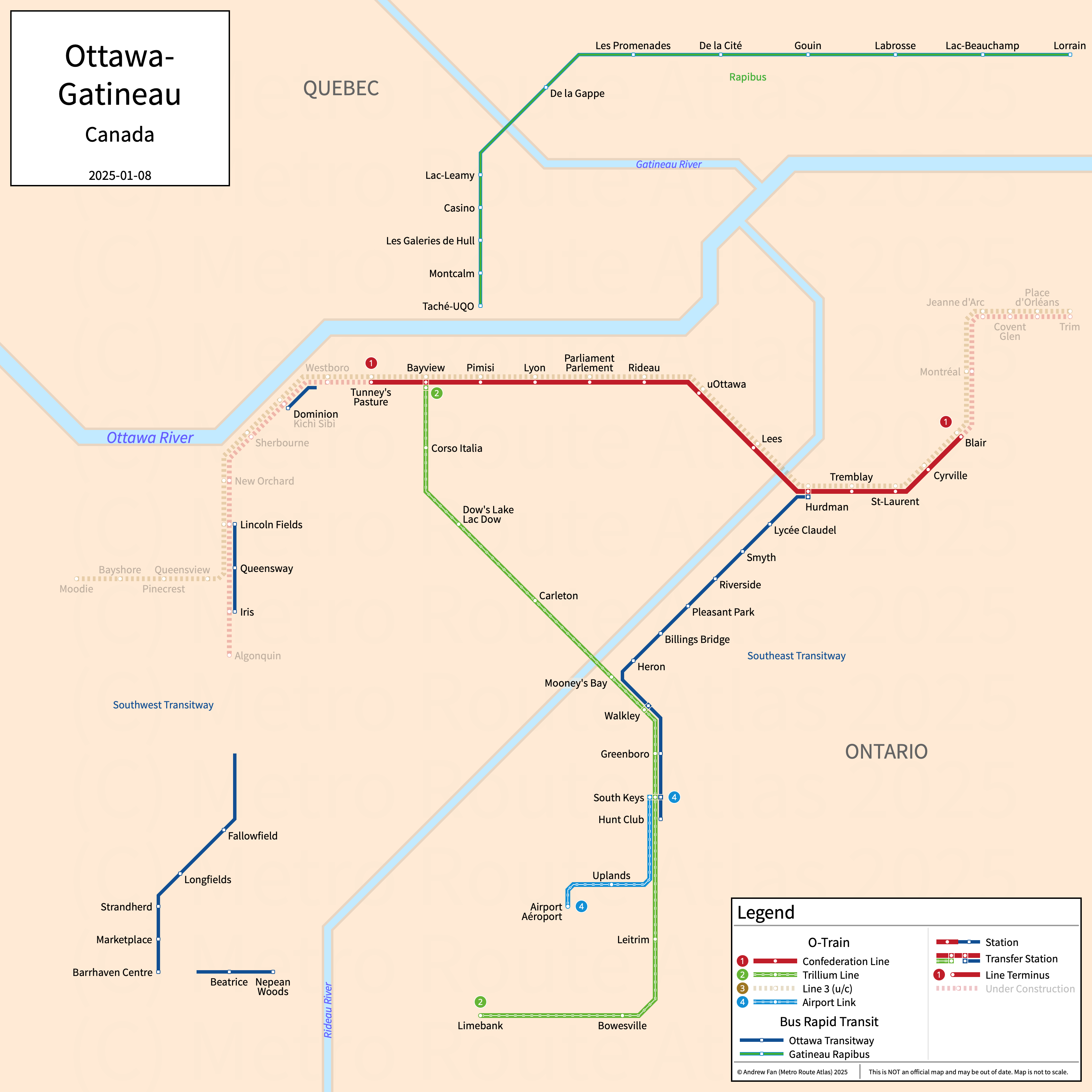
Table of Contents
Overview - Ottawa
Located on the Ottawa and Rideau Rivers across from Gatineau, Ottawa is the capital of Canada. It has approximately 1,017,000 inhabitants in the city proper as of 2021. The Ottawa-Gatineau metropolitan area comprised 1,488,307 residents as of the Canada 2021 Census.
Ottawa's rapid transit network consists of a low floor LRV light metro service, two urban mainline rail services, and multiple bus rapid transit open busways.
O-Train
Opened 2001, O-Train consists of a light metro service and two urban mainline rail services that serve the city of Ottawa, Ontario and the surrounding suburbs.
Line 1 - Confederation Line
O-Train Line 1, or the Confederation Line (Ligne de la Confédération) is a low floor LRV light metro service on an East-West alignment. It runs from Tunney's Pasture in the west to Blair in the east via downtown Ottawa, serving 13 stations.
The Confederation Line was opened in September 2019. The Confederation Line is owned by the City of Ottawa and operated by OC Transpo.
| Service | M-F Midday | M-F Rush | Sat. | Sun. | Notes |
|---|---|---|---|---|---|
| 1 Confederation | 10' | 4-6' | 9-10' | 9-10' |
Schedules -- Last Updated: May 31, 2025
Line 2 - Trillium Line
O-Train Line 2, or the Trillium Line (Ligne Trillium) is an urban mainline rail service on a North-South alignment. It runs from Bayview in the north to Limebank in the south, serving 11 stations.
The Trillium Line was opened in October 2001. It was closed between May 2020 and January 2025 for double tracking, platform extensions, new infill stations, and an extension to Limebank. Upon reopening, only weekday service is being provided. Service will roll out on Saturdays and Sundays over the course of a month or two. The Trillium Line is owned by the City of Ottawa and operated by OC Transpo.
| Service | M-F Midday | M-F Rush | Sat. | Sun. | Notes |
|---|---|---|---|---|---|
| 2 Trillium | 12' | 12' | 12' | 12' |
Schedules -- Last Updated: May 31, 2025
Line 4 - Airport Link
O-Train Line 4, or the Airport Link, is an urban mainline rail service on a Northeast-Southwest alignment. It runs from South Keys in the northeast to Airport/Aéroport in the southwest, serving 3 stations.
The Airport Link was opened in January 2025. Only weekday service is being provided for the time being. Service will roll out on Saturdays and Sundays over the course of a month or two. The Airport Link is owned by the City of Ottawa and operated by OC Transpo.
| Service | M-F Midday | M-F Rush | Sat. | Sun. | Notes |
|---|---|---|---|---|---|
| 4 Airport | 12' | 12' | 12' | 12' |
Schedules -- Last Updated: May 31, 2025
Ottawa Transitway
Opened starting in 1983, the Ottawa Transitway is a network of disconnected bus rapid transit open busways that service the city of Ottawa, Ontario and the surrounding suburbs. Due to the disjointed nature of the network, we are treating them as a single entity on this website.
Ottawa Transitway
The Ottawa Transitway consists of five (formerly seven) disconnected bus rapid transit open busways grouped into three (formerly five) sections. The transitways proper consist of the Southwest Transitway (Lincoln Fields-Iris, Fallowfield-Barrhaven Centre, Beatrice-Nepean Woods), Southeast Transitway (Hurdman-Hunt Club), and the East Transitway (Blair-Millenium, not BRT standard). Parts of the Ottawa Transitway is currently undergoing conversion to light metro.
The first section of the Ottawa Transitway was opened in 1983. The Ottawa Transitway is owned by the City of Ottawa and operated by OC Transpo.
References & Helpful Links
Ottawa Transitway at Wikipedia
Official Website for O-Train and Ottawa Transitway: OC Transpo
Maps
All Official Maps - OC Transpo [Last Accessed May 31, 2025]
Official System Map - Ottawa Rapid Transit [PDF] [Last Accessed Aug 28, 2023]
Other Sources
Ottawa, Canada at Urbanrail.net
Asset Notes
Transitway colors (and formerly O-Train colors) taken from official rapid transit map as of October 2019. O-Train colors taken from OC Transpo Website as of August 28, 2023.