Belo Horizonte, Minas Gerais, Brazil
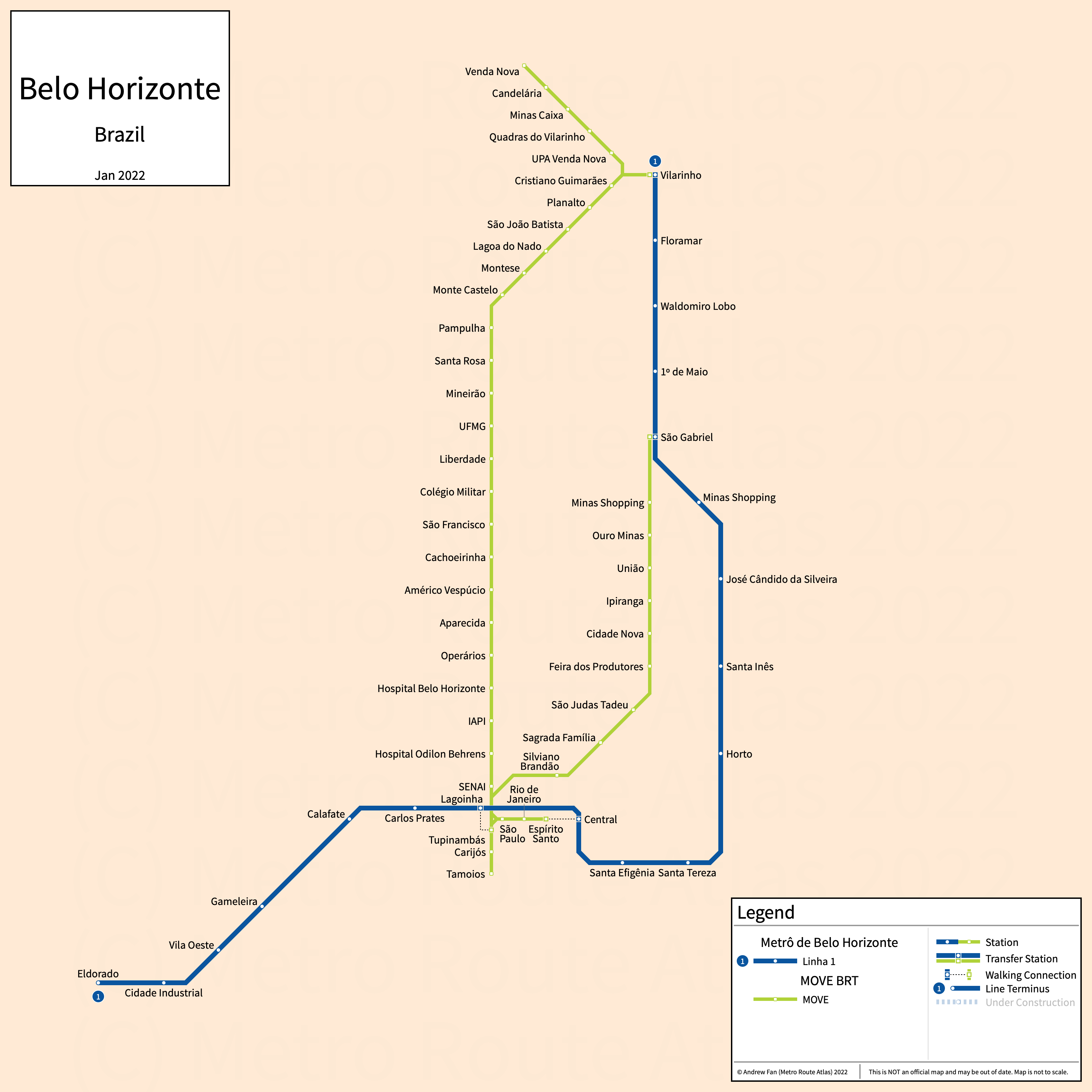
Table of Contents
Overview - Belo Horizonte
Belo Horizonte is the capital of and the largest city by population in Minas Gerais. It has approximately 2,316,000 inhabitants in the city proper as of 2022. The Belo Horizonte metropolitan area comprised 4,963,704 residents as of the 2022 IBGE census estimate.
Belo's rapid transit network consists of two metro services and two bus rapid transit corridors. There are other bus priority corridors that are not covered on this website.
Belo Horizonte Metro
Opened 1986, the Belo Horizonte Metro consists of two metro services that serve the city of Belo Horizonte, Minas Gerais and the surrounding suburbs, including Contagem in the west.
Line 1 (Linha 1)
Line 1 of the Belo Horizonte Metro is a metro service on a horizontally flipped L-shaped alignment. It runs from Novo Eldorado in the west to Vilarinho in the northeast via central Belo Horizonte, serving 21 stations.
Line 1 was opened in August 1986. The last expansion was the opening of Nova Suiça in July 2026. Line 1 is operated by Metrô BH.
Line 2 (Linha 2)
Line 2 of the Belo Horizonte Metro is a metro service on a northeast-southwest alignment. It runs from Amazonas in the southwest to Nova Suiça in the northeast, serving 2 stations.
Line 2 was opened in July 2026. Line 2 is operated by Metrô BH.
MOVE
Opened 2014, MOVE consists of two bus rapid transit lines that serve the city of Belo Horizonte, Minas Gerais and the surrounding suburbs.
Cristiano Machado
The Cristiano Machado corridor of MOVE is a bus rapid transit line on a North-South alignment. It runs from the Área Central corridor in the south to São Gabriel in the north, serving 10 stations along Av. Cristiano Machado.
The Cristiano Machado corridor was opened in 1975 and upgraded to BRT in March 2014.
Antônio Carlos
The Antônio Carlos corridor of MOVE is a bus rapid transit line on a North-South alignment. It runs from the Área Central corridor in the south to Venda Nova in the north, serving 27 stations along Av. Pres. Antônio Carlos, Av. Dom Pedro I, and Av. Vilarinho.
The Antônio Carlos corridor was opened in 2007 and upgraded to BRT in May 2014.
Área Central
MOVE Área Central is a bus rapid transit line on a circumflex alignment. It runs from Tamoios in the west to Espírito Santo in the east, serving 6 stations along Av. Paraná and Av. Santos Dumont.
The Área Central was opened in March 2014.
References & Helpful Links
Belo Horizonte Metro at Wikipedia | Metrô de Belo Horizonte at Wikipedia.pt
Official Website for Belo Horizonte Metro: metrôBH
Official Website for MOVE: SUMOB
Maps
Official System Map - Belo Horizonte Metro [Last Accessed July 07, 2026]
Official System Map - MOVE [PDF] [Last Accessed September 27, 2025]
Other Sources
Belo Horizonte, Brazil at Urbanrail.net
Belo Horizonte, Brazil at BRTDATA.org
Other Websites
External Citations
Asset Notes
Belo Horizonte metro colors originally taken from official strip map as of January 12, 2022. As of September 27, 2025, using colors from the current official map.
MOVE colors taken from official system map as of January 12, 2022.