New York City, New York, USA
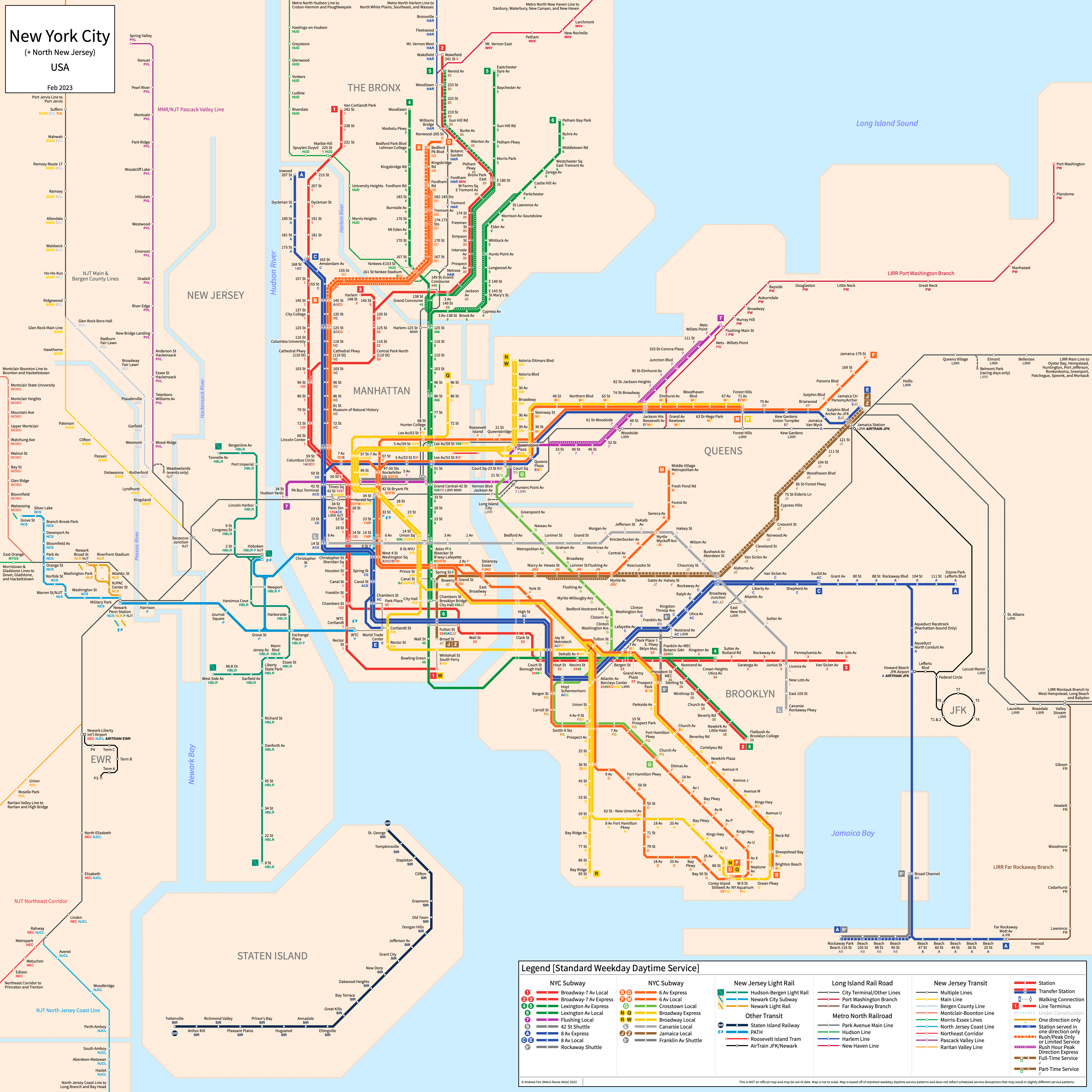
Table of Contents
Overview - New York City

Located at the mouth of the Hudson River, New York City is the largest city by population in both New York and the United States of America as a whole. It has approximately 8,258,000 inhabitants in the city proper as of 2023. The New York City metropolitan area (New York-Newark-Jersey City) comprised 19,498,249 residents as of the 2023 US Census Bureau Estimate.
New York City's rapid transit network consists of 9 metro trunk lines and a metro network connecting the city to New Jersey. It also has an aerial tram as well as four regional and commuter rail networks. It also has arterial bus rapid transit services, which are not covered on this website.
New York City Subway
Opened 1904, the New York City Subway consists of 22 metro services and three shuttles that serve the city of New York City, New York. The network is made up of numerous individual lines (the physical train tracks) built by three different companies (the IRT, BMT, and IND), and the services run across different portions of these lines. Services are identified with a specific trunk line which determines their route color.
The entirety of the New York City Subway network is operated by the Metropolitan Transit Authority of New York.
Planned extensions to the New York City Subway system as of July 2019 include Phase 2 of the Second Avenue Subway.
All strip maps reflect weekday daytime service, with some exceptions. Rush hour express services are not visibly shown. Special service patterns (e.g. M to 96 St) are not shown. Certain rush hour service patterns may not be shown.
IRT Broadway-7th Avenue Line
The Broadway-7th Avenue Trunk Line of the New York City Subway is a metro trunk line on a North-South alignment. It is served by three services.
The 1 (7 Av - B'way Local) runs from Van Cortlandt Park-242nd St in the Bronx to South Ferry in Lower Manhattan and serves 38 stations on a North-South alignment along Broadway and 7th Avenue. It runs above ground in the Bronx and northern Manhattan as well as over the 125th Street Viaduct, and is otherwise underground for the entirety of its route. It makes all local stops.
The 2 (7 Av - B'way Express) runs from Wakefield-241st Street in the Bronx to Brooklyn College via Manhattan and serves 49 stations. North of 96th Street in Manhattan, it runs local, and runs above ground along the White Plains Road line in the Bronx. South of Chambers Street, it also runs local, and serves stops along Eastern Parkway and Nostrand Avenue in Brooklyn. It makes express stops along 7th Avenue and Broadway.
The 3 (7 Av - B'way Express) runs from Harlem-148th Street in Manhattan to New Lots Avenue in Brooklyn and serves 34 stations. North of 96th Street in Manhattan, it runs local along Lenox Avenue. South of Chambers Street, it also runs local, and serves stops along Eastern Parkway and Livonia Avenue in Brooklyn, on the latter of which it runs elevated. It makes express stops along 7th Avenue and Broadway.
Portions of the current-day Broadway-7th Avenue Line were opened as part of the original subway in 1904 and the last extension to the line was the reopening of the Cortlandt Street station in Sept 2018.
IRT Lexington Avenue Line
The Lexington Avenue Trunk Line of the New York City Subway is a metro trunk line on a North-South alignment. It is served by three services.
The 4 (Lexington Av Express) runs from Woodlawn in the Bronx to Crown Heights - Utica Avenue in Brooklyn and serves 28 stations. It runs above ground in the Bronx along Jerome Avenue, makes express stops along Lexington Avenue in Manhattan, and makes express stops along Eastern Parkway in Brooklyn.
The 5 (Lexington Av Express) runs from Eastchester - Dyre Avenue and Nereid Avenue (rush hours only) in the Bronx to Brooklyn College via Manhattan and serves 45 stations. It runs on an old railway ROW in the Bronx before joining the White Plains Road line at East 180 St, and runs express along White Plains Road in the peak direction during rush hours (local otherwise). Down Lexington Avenue in Manhattan and along Eastern Parkway in Brooklyn, it makes express stops, and runs local on Nostrand Avenue in Brooklyn. During weekends, it terminates at Bowling Green.
The 6 (Lexington Av Local) runs from Pelham Bay Park in the Bronx to Brooklyn Bridge - City Hall in Lower Manhattan and serves 38 stations. In the Bronx along the Pelham Line, it runs local with rush hour peak-direction express service. It makes all local stops along Lexington Avenue in Manhattan
Portions of the current-day Lexington Avenue Line were opened as part of the original subway in 1904. While it has had numerous improvements over the years, it has not had meaningful extensions since the opening of the 59th Street lower level platforms in 1962.
IRT Flushing Line
The Flushing Line of the New York City Subway is a metro line on an East to West alignment. It is served by one service.
The 7 (Flushing Local) runs from Flushing - Main Street in the East to 34 St - Hudson Yards in Manhattan, serving 22 stations. It runs underground in Manhattan, making all stops, and has rush hour peak-direction express service east of Queensboro Plaza. It runs above Queens Blvd and Roosevelt Avenue in Queens.
The Flushing Line was opened in 1915 and the last extension to the line was the extension to Hudson Yards in Sept 2015.
IRT 42nd Street Shuttle
The S (42nd Street Shuttle) runs underground from Grand Central to Times Square under 42nd Street in Manhattan.
The 42nd Street Shuttle was part of the original subway opened in 1904, and with a 732 meter route it is the shortest route in the system. The shuttle itself began service in 1918 when the Broadway-7th Avenue and Lexington Avenue lines were formed.
IND 8th Avenue Line
The 8th Avenue Trunk Line of the New York City Subway is a metro trunk line on a North-South alignment. It is served by three services.
The A (8 Av Express) runs from 207 St in Inwood in northern Manhattan to Lefferts Blvd and Far Rockaway - Mott Avenue in Queens via 8th Avenue, Fulton Street, Liberty Avenue, and the former Rockaway Branch of the LIRR, serving 44 stations (Note: rush hour only limited service to Rockaway Park not shown on map above). It makes express stops on 8th Avenue from 168th Street to Chambers Street in Manhattan and from Hoyt-Schermerhorn to Euclid Avenue in Brooklyn. Select rush hour trips go to Rockaway Park - Beach 116 St.
The C (8 Av Local) runs from 168 St in Manhattan to Euclid Avenue in Brooklyn along 8th Avenue and Fulton Street, serving 40 stations. It makes all local stops.
The E (8 Av Local) runs from Jamaica Center in Queens to the World Trade Center complex in Lower Manhattan via Queens Blvd, 53rd Street, and 8th Avenue, serving 22 stations (Note that 75 Av and Briarwood are only served on evenings, late nights, and weekends). It runs express in Queens and local in Manhattan.
The 8th Avenue trunk line was opened in Sept 1932 from 207th Street to Chambers Street. The latest major change to the services running along 8th Avenue was the opening of the Archer Avenue Line in Dec 1988.
IND 6th Avenue Line
The 6th Avenue Trunk Line of the New York City Subway is a metro trunk line on a North-South alignment. It is served by four services.
The B (6 Av Express) runs from 145 St in northern Manhattan to Brighton Beach in Brooklyn along Central Park West, 6th Avenue and the Brighton Beach Line, serving 37 stations. During rush hours (and every other train on weekdays midday) it serves stations past 145th St on Grand Concourse, running up to Bedford Park Blvd. It makes local stops in Brooklyn and along Central Park West, and makes express stops along 6th Avenue and the Brighton Beach Line. It only runs on weekdays.
The D (6 Av Express) runs from Norwood - 205 St in the Bronx to Coney Island in Brooklyn along Grand Concourse in the Bronx, Central Park West and 6th Avenue in Manhattan, and the 4th Avenue and West End Lines in Brooklyn, serving 36 stations. It runs express along its entire length, though it makes local stops on Grand Concourse outside of rush hours when it serves as a peak-direction express.
The F (6 Av Local) runs from Jamaica - 179 St in Queens to Coney Island in Brooklyn via Queens Blvd in Queens, 53rd Street and 6th Avenue in Manhattan, and the Culver Line in Brooklyn, serving 45 stations. It runs express in Queens and local in Manhattan and Brooklyn.
The M (6 Av Local) runs from Forest Hills - 71 Av in Queens to Middle Village - Metropolitan Avenue in Queens via Queens Blvd in Queens, 63rd Street and 6th Avenue in Manhattan, and the Jamaica and Myrtle Lines in Brooklyn and Queens, serving 36 stations. It makes all local stops. During weekends, it only runs from Delancey - Essex to Metropolitan Avenue.
The 6th Avenue trunk line was completed in 1940. The latest major change to the services running along 6th Avenue was the daytime swap of the F and M Lines between the 53 St and 63 St tunnels in December 2025.
IND Crosstown Line
The Crosstown Trunk Line of the New York City Subway is a metro trunk line on a North to South alignment. It is served by one service.
The G (Crosstown Local) runs from Court Square in Long Island City, Queens to Church Av in Brooklyn, serving 21 stations. It makes all local stops and is entirely underground except for the Smith Street Viaduct.
The Crosstown Line was opened in August 1933.
IND Rockaway Park Shuttle
The Rockaway Park Branch of the Rockaway Line of the New York City Subway is a metro line on an East to West alignment. It is served by one service.
The S (Rockaway Park Shuttle) runs from Rockaway Park - Beach 116 St to Broad Channel along the Rockaway Park Branch of the Rockaway Line, serving 5 stations. It occasionally utilizes the H bullet during major outages along the line between Howard Beach and Broad Channel when it runs the entire length of the peninsula from Rockaway Park to Far Rockaway. During summer, it may be extended north to Rockaway Blvd on the Liberty Avenue Line.
The Rockaway Line was transferred from the LIRR to the New York City Transit Authority in 1952 and was opened in June 1956.
BMT Broadway Line
The Broadway Trunk Line of the New York City Subway is a metro trunk line on a North to South alignment. It is served by four services.
The N (Broadway Express) runs from Ditmars Blvd in Astoria, Queens to Coney Island in Brooklyn, serving 30 stations. It makes express stops along Broadway during weekdays and along 4th Avenue, and makes local stops along the Astoria and Sea Beach lines in Queens and Brooklyn, respectively. During weekends, it uses the Montague Street tunnel and makes stops in Lower Manhattan.
The Q (Broadway Express) runs from 96 St in Manhattan to Coney Island in Brooklyn, serving 29 stations. It makes express stops along Broadway, and makes local stops along the 2nd Avenue and Brighton Beach lines in Manhattan and Brooklyn, respectively.
The R (Broadway Local) runs from 71 Avenue in Forest Hills, Queens to Bay Ridge - 95 St in Brooklyn, serving 45 stations on Queens Blvd, Broadway, and 4th Avenue. It makes all local stations and runs entirely underground.
The W (Broadway Local) runs from Ditmars Blvd in Astoria, Queens to Whitehall Street in Lower Manhattan, serving 23 stations on the Astoria and Broadway Lines. It makes all local stations. It only runs on weekdays.
The Broadway Line was opened in April 1917. The last major adjustment to the services on the Broadway Line was the reintroduction of the W for the extension of the Q to 2nd Av/96 St in July 2017.
BMT Jamaica Line
The Jamaica Trunk Line (or Nassau Street Line) of the New York City Subway is a metro trunk line on an East to West alignment. It is served by two services.
The J and Z (Jamaica Local) run from Broad Street in Lower Manhattan over the Williamsburg Bridge and then along Broadway, Fulton Street, and Jamaica Av as part of the Jamaica Line before entering the tunnel under Archer Avenue in Jamaica Queens, terminating at Jamaica Center at Parsons Blvd and serving 30 stations. The Z only runs during rush hours, when the J and Z run with a skip-stop service pattern, serving 20 and 21 stations each respectively. During rush hours, trains in the peak direction towards Manhattan skip stations between Myrtle Av and Marcy Av.
In the strip map above, the J and Z icons refers to stations exclusively served by the specified service during rush hours. All other stations besides those on the aforementioned section between Myrtle Av and Marcy Av are served by both during rush hours.
The Jamaica Line was opened in 1885. The last major adjustment to the services on the Jamaica Line was the extension of the Jamaica Line onto Archer Avenue in December 1988, which marked the start of the skip-stop service pattern.
BMT Canarsie Line
The 14 St - Canarsie Trunk Line of the New York City Subway is a metro trunk line on an East to West alignment. It is served by one service.
The L (Canarsie Local) runs from 8th Avenue in Manhattan to Rockaway Pkwy in Canarsie, Brooklyn along 14th Street and the Canarsie Line, serving 24 stations.
The last extension to the Canarsie Line was the extension to 8th Avenue in 1931.
BMT Franklin Avenue Shuttle
The Franklin Avenue Line of the New York City Subway is a metro line on a North to South alignment. It is served by one service.
The S (Franklin Avenue Shuttle) runs from Franklin Avenue (at Fulton Street) to Prospect Park along a former part of the Brighton Beach Line, serving 4 stations.
The Franklin Avenue Shuttle was rebuilt in October 1999.
Staten Island Railway
Staten Island Railway
Opened 1860, the Staten Island Railway is a regional rail system serving the borough of Staten Island (Richmond County). The only surviving line is a north-south line serving the eastern portion of Staten Island.
The Staten Island Railway is a regional rail service on a primarily North-South alignment, running from the St. George ferry terminal in the north to Tottenville in the south and serving 21 stations.
The currently operational portion of the Staten Island Railway was opened in 1860 and the last expansion to the line was the replacement of the Nassau and Atlantic stations with a new Arthur Kill station in January 2017. The Staten Island Railway is operated by the Metropolitan Transit Authority of New York.
| Service | M-F Midday | M-F Rush | Sat. | Sun. | Notes |
|---|---|---|---|---|---|
| SIR | 30' | 4/11-15' | 30' | 30' | *1 |
Schedules -- Last Updated: Dec 08, 2025
*1 - Combined service headway shown. Every other train runs express rush hours using a Express-4 min-Local-11 min schedule. See timetable for details
Port Authority Trans-Hudson (PATH)
For information on the Port Authority Trans-Hudson (PATH), refer to the Newark-Jersey City Page, covering North New Jersey.
Long Island Rail Road (LIRR)
For information on the Long Island Rail Road, refer to the Hempstead Page, covering Central Nassau County. For convenience, all LIRR lines have their information on the Hempstead Page, even those which are entirely within New York City.
Roosevelt Island Tramway
Opened 1976, the Roosevelt Island Tramway is an aerial tramway service connecting Roosevelt Island to Midtown Manhattan and consists of a single service.
Roosevelt Island Tramway
The Roosevelt Island Tramway is a 940 m aerial tramway service running east to west between 2 Av/59 St in Midtown Manhattan and Roosevelt Island. There are two stations.
The Roosevelt Island Tramway is operated by the Roosevelt Island Operating Corporation.
Metro-North Railroad
Opened in its current form in 1983, Metro-North Railroad is a commuter and regional railway connecting New York City with its northern suburbs, including Rockland, Westchester, Putnam and Dutchess counties in New York and Fairfield and New Haven counties in Connecticut. It consists of three main lines on the east side of the Hudson River that terminate at Grand Central Terminal in New York City, as well as two lines extending out of northern New Jersey, with these trains terminating in Hoboken, New Jersey. All services east of the Hudson River are operated by the Metropolitan Transit Authority of New York, while Pascack Valley and Port Jervis Line services are operated by New Jersey Transit.
Stations past Croton-Harmon on the Hudson Line, Southeast on the Harlem Line, and Stamford on the New Haven Line are not shown. Strip maps show service patterns rather than physical lines. The Pascack Valley Line is located under New Jersey Transit. The Port Jervis Line is located on the Newark-Jersey City page as it does not enter New York City.
Hudson Line
The Hudson Line is a commuter rail line on a primarily North-South alignment, running from Grand Central Terminal in New York City to Croton-Harmon in Westchester County and Poughkeepsie in Dutchess County via Westchester and Putnam counties and serving 29 stations.
The current form of the Hudson Line was taken control of by Metro-North in 1983. The last expansion of the line was East 153 St Station, opened May 2009.
Harlem Line
The Harlem Line is a commuter rail line on a primarily North-South alignment, running from Grand Central Terminal in New York City to North White Plains in Westchester County, Southeast in Putnam County, and Wassaic in Dutchess County via Westchester and Putnam counties and serving 38 stations.
The current form of the Harlem Line was taken control of by Metro-North in 1983. The last expansion of the line was restoration of service to Wassaic in July 2000.
New Haven Line
The New Haven Line is a commuter rail line on a primarily Northeast-South alignment, running from Grand Central Terminal in New York City to Stanford and New Haven in Connecticut, with branches to New Canaan, Danbury, and Waterbury - all in Connecticut. In total, 30 stations are served on the main line, and 17 stations are served on the branches.
The current form of the New Haven Line was taken control of by Metro-North in 1983. The last expansion of the line was the opening of West Haven station in August 2013.
References & Helpful Links
New York City Subway at Wikipedia
Staten Island Railway at Wikipedia
Port Authority Trans-Hudson at Wikipedia
Roosevelt Island Tramway at Wikipedia
Long Island Rail Road at Wikipedia
Metro-North Railroad at Wikipedia
Official Website for New York City Transit: Metropolitan Transit Authority
Official Website for Port Authority Trans-Hudson: Port Authority Trans-Hudson
Official Website for Long Island Rail Road: Metropolitan Transit Authority
Official Website for Metro-North Railroad: Metropolitan Transit Authority
Maps
All Official Maps - MTA [Last Accessed December 08, 2025]
Official System Map - New York City Subway [PDF] [Last Accessed December 08, 2025]
Official System Map - Port Authority Trans-Hudson [Last Accessed December 08, 2025]
Official System Map - Long Island Rail Road & Metro-North Railroad [Last Accessed December 08, 2025]
Unofficial Map - New York City Subway [March 2016] by Cameron Booth, London Tube Map style (www.cambooth.net)
Unofficial Map - New York City Subway [June 2019] by Jug Cerovic (www.inat.fr)
Unofficial Map - New York & New Jersey Subway [2016] by Stewart Mader (www.stewartmader.com)
Unofficial Map - New York City Subway [Dec 2016] PDF by Tommi Moilanen (medium.com; tommimoilanen.com)
Other Sources
New York City, USA at Urbanrail.net
New York City, USA at BRTDATA.org
Other Websites
Asset Notes
Route colors for the New York City Subway, Metro North, and the Long Island Rail Road are the official route colors in use as of May 2019 as stated on MTA Line Colors.
Route color for the Staten Island Railway taken from Wikipedia.
Metro North text color taken from official MTA logo.
This page uses the CSS from www.jsvine.com/mta-colors/ in order to display line bullets in regular text.