Cleveland, Ohio, USA
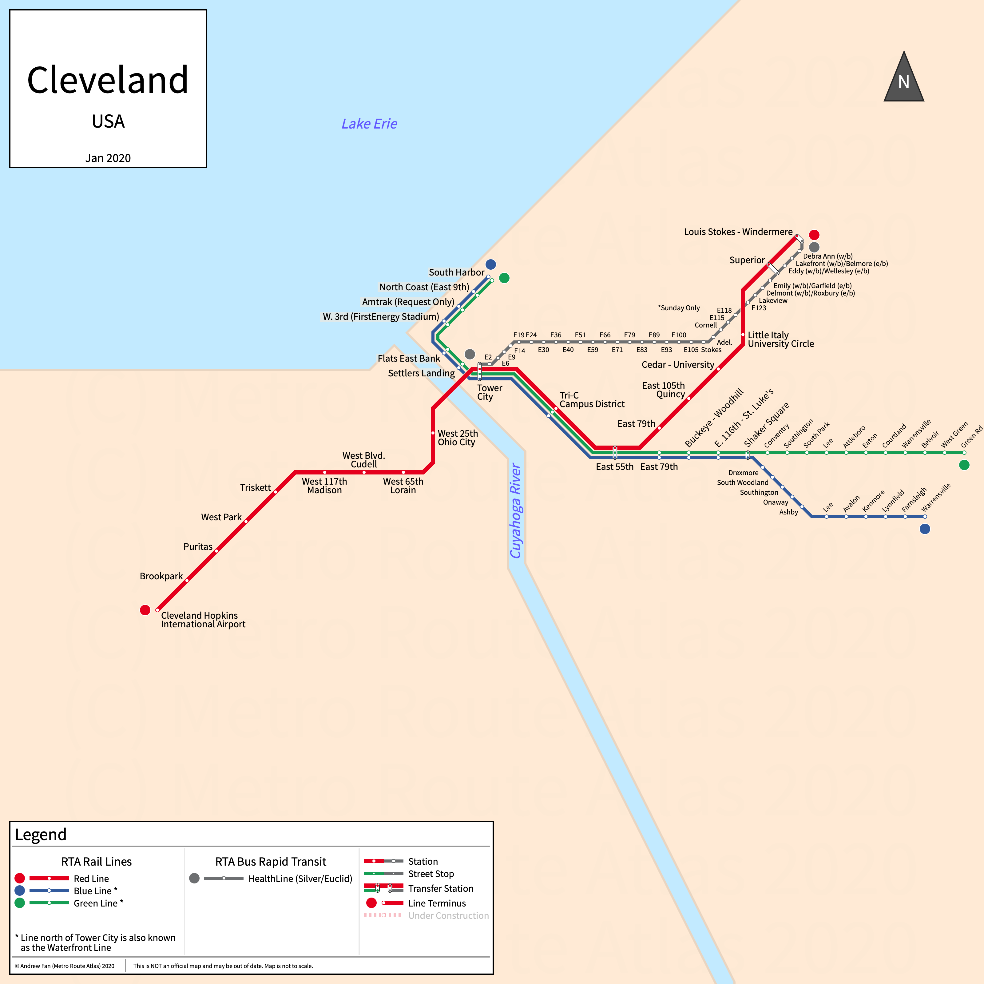
Table of Contents
Overview - Cleveland

Located at the junction of the Cuyahoga River and Lake Erie, Cleveland is the seat of Cuyahoga County and the second largest city by population in Ohio after Columbus. It has approximately 363,000 inhabitants in the city proper as of 2023. The Cleveland metropolitan area (Cleveland-Elyria) comprised 2,158,932 residents as of the 2023 US Census Bureau Estimate.
Cleveland's rapid transit network consists of a metro service, two light rail services, and a bus rapid transit service.
RTA The Rapid
The Rapid consists of one metro service, two light rail services, and one bus rapid transit service that serve the city of Cleveland, Ohio and Cuyahoga County.
Red Line
The Red Line, also known as the Airport-Windermere Line, is a metro service on a roughly Southwest-Northeast alignment, running from Cleveland Hopkins International Airport in the west to Windermere in the east via Tower City in downtown Cleveland utilizing freight railroad rights-of-way, serving 18 stations. From Tower City to East 55th, it shares track with the Blue and Green lines but has separate platforms due to different platform heights.
The Red Line was opened in March 1955 and the last extension to the line was the extension to the airport in 1968. The Red Line is owned and operated by the Greater Cleveland Regional Transit Authority.
| Service | M-F Midday | M-F Rush | Sat. | Sun. | Notes |
|---|---|---|---|---|---|
| Red | 15' | 15' | 15' | 15' |
Schedules -- Last Updated: Feb 17, 2025
Shaker Heights & Waterfront Lines
The Blue Line (Van Aken Line), Green Line (Shaker Line), and Waterfront Line comprise Cleveland's light rail network, running from South Harbor on the Waterfront Line through Tower City in downtown Cleveland to Warrensville-Van Aken and Green Road in Shaker Heights. From Tower City to East 55th, they share track with the Red line but have separate platforms due to different platform heights. East of East 55th, they operate at street level. Beyond Shaker Square, the Blue Line runs down the median of Van Aken Boulevard while the Green Line runs down the median of Shaker Boulevard. The Waterfront Line is currently only operated on weekends and holidays.
The current-day Green Line was opened in December 1913. The current-day Blue Line was opened in April 1920. The last extension to the light rail system was the Waterfront Line (an extension of the Blue and Green lines) to the South Harbor in July 1996. The Blue and Green Lines are owned and operated by the Greater Cleveland Regional Transit Authority.
| Service | M-F Midday | M-F Rush | Sat. | Sun. | Notes |
|---|---|---|---|---|---|
| Blue | 30' | 20' | 15' | 15' | *1 |
| Green | 30' | 20' | 15' | 15' | *1 |
Schedules -- Last Updated: Feb 17, 2025
*1 - Waterfront Line (Tower City to South Harbor) service not provided early morning, evenings, or weekdays
HealthLine BRT
The HealthLine (formerly the Silver Line) is a bus rapid transit service on a roughly east-west alignment, running from Public Square and Tower City in downtown Cleveland to Windermere in the east primarily along Euclid Avenue. It has dedicated bus-only lanes from Public Square to East 105th, after which it runs on standard lanes.
The HealthLine was opened in October 2008. The HealthLine is owned and operated by the Greater Cleveland Regional Transit Authority.
| Service | M-F Midday | M-F Rush | Sat. | Sun. | Notes |
|---|---|---|---|---|---|
| HealthLine | 15' | 15' | 15' | 15' |
Schedules -- Last Updated: Feb 17, 2025
References & Helpful Links
RTA Rapid Transit at Wikipedia
Official Website for RTA Rapid Transit: Greater Cleveland Regional Transit Authority
Maps
All Official Maps - Greater Cleveland Regional Transit Authority [Last Accessed Feb 17, 2025]
Official System Map - RTA Rapid [PDF] [Last Accessed Feb 17, 2025]
Official Line Map - HealthLine BRT [PDF] [Last Accessed Feb 17, 2025]
Other Sources
Cleveland, USA at Urbanrail.net
Asset Notes
Line colors taken from RTA April 2019 system map.