São Paulo, São Paulo, Brazil
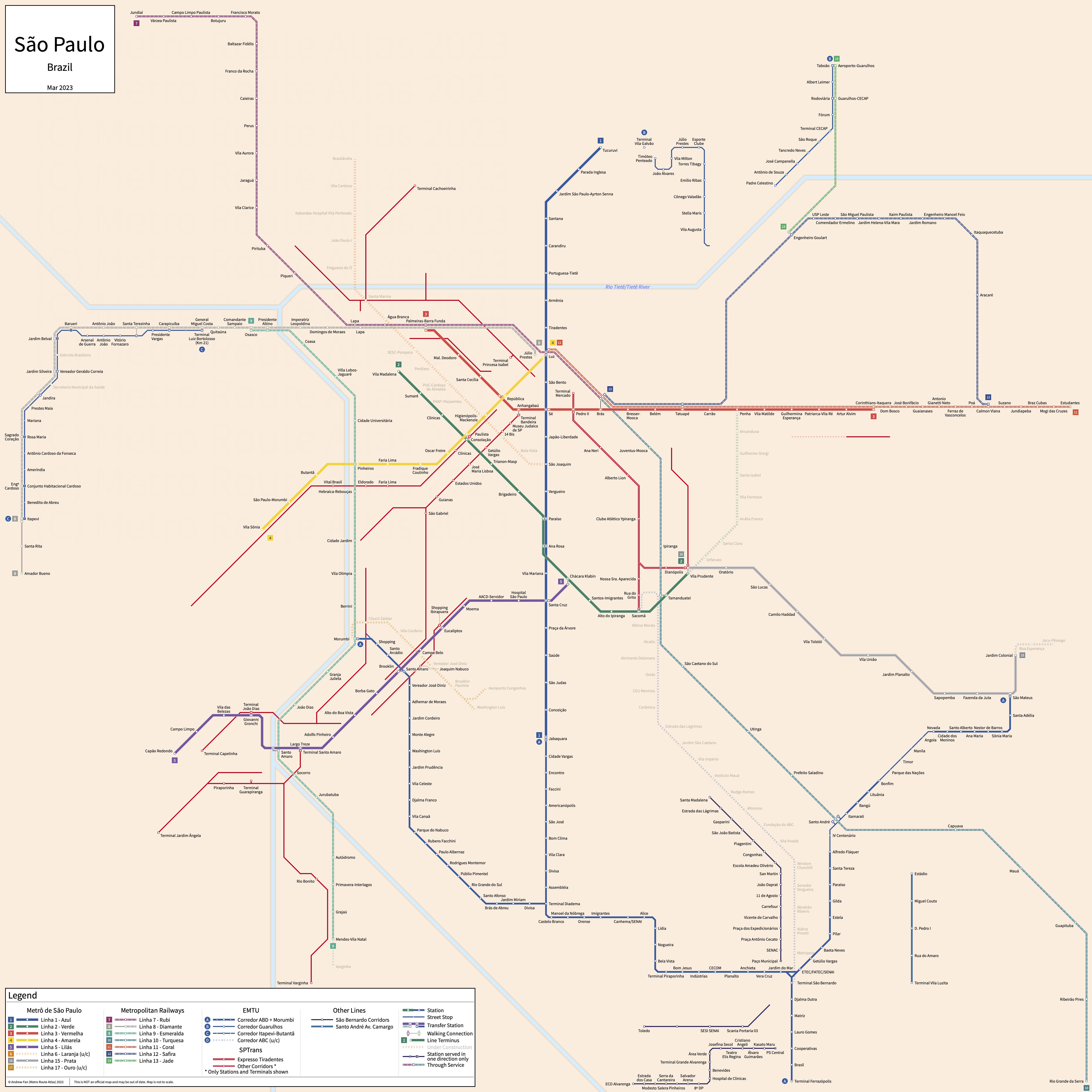
Table of Contents
Overview - São Paulo
Located on the Tietê River, São Paulo is the capital of São Paulo and the largest city by population in Brazil. It has approximately 11,452,000 inhabitants in the city proper as of 2022. The São Paulo metropolitan area comprised 20,673,280 residents as of the 2022 IBGE census estimate.
São Paulo's rapid transit network consists of 6 metro services, two straddle beam monorail light metro services, 7 urban mainline rail/regional rail services, and three bus rapid transit networks. It also has two BRT-Lite corridors under ARTESP (formerly under the EMTU), 12 BRT-Lite corridors operated by SP Trans, and four BRT-Lite corridors built by the Prefeitura de São Bernardo do Campo. There is also a BRT-Lite corridor along Av. Santos Dumont in Guarulhos which is not covered on this website.
São Paulo Metro
Opened 1974, São Paulo Metro consists of six metro services and two straddle beam monorail light metro services that serve the city of São Paulo, São Paulo and the surrounding suburbs.
Line 1 - Blue (Linha 1 - Azul)
Line 1 of the São Paulo Metro is a metro service on a North-South alignment. It runs from Jabaquara in the south to Tucuruvi in the north via Luz, serving 23 stations.
Line 1 was opened in September 1974 and the last extension to the line was to Tucuruvi in April 1998. Line 1 is owned by the State of São Paulo and operated by the Companhia do Metropolitano de São Paulo.
Line 2 - Green (Linha 2 - Verde)
Line 2 of the São Paulo Metro is a metro service on an East-West alignment. It runs from Vila Madalena in the west to Vila Prudente in the east, serving 14 stations.
Line 2 was opened in January 1991 and the last expansion to the line was the opening of Tamanduateí in September 2010. Line 2 is owned by the State of São Paulo and operated by the Companhia do Metropolitano de São Paulo.
Line 3 - Red (Linha 3 - Vermelha)
Line 3 of the São Paulo Metro is a metro service on an East-West alignment. It runs from Palmeiras-Barra Funda in the west to Corinthians-Itaquera in the east via Brás, serving 18 stations.
Line 3 was opened in March 1979 and the last extension to the line was to Palmeiras-Barra Funda in December 1988. Line 3 is owned by the State of São Paulo and operated by the Companhia do Metropolitano de São Paulo.
Line 4 - Yellow (Linha 4 - Amarela)
Line 4 of the São Paulo Metro is a metro service on an East-West alignment. It runs from Vila Sonia in the west to Luz in the east, serving 11 stations.
Line 4 was opened in May 2010 and the last extension to the line was to Vila Sonia in December 2021. Line 4 is owned by the State of São Paulo and operated by Motiva.
Line 5 - Lilac (Linha 5 - Lilás)
Line 5 of the São Paulo Metro is a metro service on an East-West alignment. It runs from Capão Redondo in the west to Chácara Klabin in the east, serving 17 stations.
Line 5 was opened in October 2002 and the last extension to the line was to Chácara Klabin in September 2018. Line 5 is owned by the State of São Paulo and operated by ViaMobilidade.
Line 6 - Orange (Linha 6 - Laranja)
Line 6 of the São Paulo Metro is a metro service on a Northwest-Southeast alignment. It runs from João Paulo I in the northwest to Perdizes in the southeast, serving 6 stations.
Line 6 was opened in July 2026. Line 6 is owned by the State of São Paulo and operated by Linha Uni.
Line 15 - Silver (Linha 15 - Prata)
Line 15 of the São Paulo Metro is a straddle beam monorail light metro service on an East-West alignment. It runs from Vila Prudente in the west to Jardim Colonial in the east, serving 11 stations.
Line 15 was opened in August 2014 and the last extension to the line was to Jardim Colonial in December 2021. Line 15 is owned by the State of São Paulo and operated by the Companhia do Metropolitano de São Paulo.
Line 17 - Gold (Linha 17 - Ouro)
Line 17 of the São Paulo Metro is a straddle beam monorail light metro service on an East-West alignment. It runs from Morumbi in the west to Aeroporto de Congonhas and Washington Luís in the east, serving 8 stations.
Line 17 was opened in March 2026, with the Washington Luís branch opening in June 2026. Line 17 is owned by the State of São Paulo and operated by the Companhia do Metropolitano de São Paulo.
Metropolitan Railways
São Paulo's Metropolitan Railway network consists of seven urban mainline rail services (including one with a regional rail shuttle) that serve the city of São Paulo, São Paulo and the surrounding suburbs.
Line 7 - Ruby (Linha 7 - Rubi)
Line 7 of the São Paulo Metropolitan Railways is an urban mainline rail service on a North-South alignment. It runs from Jundiaí and Francisco Morato in the north to Palmeiras-Barra Funda in the south, serving 17 stations. Through services operated onto Line 10 at Luz until August 2025, when the line was cut back to Palmeiras-Barra Funda.
Line 7 was taken over by the CPTM in 1994 as Line A - Brown (Marrom). Through service with Line 10 began May 2021 and Line 10 took over the portion of Line 7 between Luz and Brás in early 2023, additionally taking over the section between Palmeiras-Barra Funda and Luz in September 2025. Line 7 is owned by the State of São Paulo and operated by TIC Trens.
Line 8 - Diamond (Linha 8 - Diamante)
Line 8 of the São Paulo Metropolitan Railways is an urban mainline rail service on an East-West alignment. It runs from Itapevi in the west to Júlio Prestes in the east, serving 20 stations. A regional rail shuttle runs from Itapevi to Amador Bueno with two intermediate stations.
Line 8 was taken over by the CPTM in 1994 as Line B - Gray (Cinza). The last expansion was the reopening of Ambuitá in April 2025. Line 8 is owned by the State of São Paulo and operated by ViaMobilidade.
Line 9 - Emerald (Linha 9 - Esmeralda)
Line 9 of the São Paulo Metropolitan Railways is an urban mainline rail service on a North-South alignment. It runs from Varginha in the south to Osasco in the north, serving 21 stations.
Line 9 was taken over by the CPTM in 1994 as Line C - Sky Blue (Celeste). The last extension was to Varginha in January 2025. Line 9 is owned by the State of São Paulo and operated by ViaMobilidade.
Line 10 - Turquoise (Linha 10 - Turquesa)
Line 10 of the São Paulo Metropolitan Railways is an urban mainline rail service on a Northwest-Southeast alignment. It runs from Palmeiras-Barra Funda in the northwest to Mauá and Rio Grande da Serra in the southeast, serving 15 stations. Through services operated onto Line 7 at Luz until August 2025, when the line was extended to Palmeiras-Barra Funda.
Line 10 was taken over by the CPTM in 1994 as Line D - Beige (Bege). Through service with Line 7 began May 2021 and Line 10 took over the portion of Line 7 between Luz and Brás in early 2023, additionally taking over the section between Palmeiras-Barra Funda and Luz in September 2025. Line 10 is owned by the State of São Paulo and operated by the Companhia Paulista de Trens Metropolitanos.
Line 11 - Coral (Linha 11 - Coral)
Line 11 of the São Paulo Metropolitan Railways is an urban mainline rail service on an east-west alignment. It runs from Palmeiras-Barra Funda in the west to Guaianases and Estudantes in the east, serving 17 stations.
Line 11 was taken over by the CPTM in 1994 as Line E - Orange (Laranja). The last extension was to Palmeiras-Barra Funda in September 2025 to cover for the loss of direct Line 7 service into the city center. Line 11 is owned by the State of São Paulo and operated by the Companhia Paulista de Trens Metropolitanos.
Line 12 - Sapphire (Linha 12 - Safira)
Line 12 of the São Paulo Metropolitan Railways is an urban mainline rail service on an east-west alignment. It runs from Brás in the west to Engenheiro Manoel Feio and Calmon Viana in the east, serving 14 stations.
Line 12 was taken over by the CPTM in 1994 as Line F - Violet (Violeta). Line 12 is owned by the State of São Paulo and operated by the Companhia Paulista de Trens Metropolitanos.
Line 13 - Jade (Linha 13 - Jade)
Line 13 of the São Paulo Metropolitan Railways is an urban mainline rail service on a northeast-southwest alignment. It runs from Engenheiro Goulart in the southwest to Aeroporto-Guarulhos in the northeast, serving 3 stations.
Line 13 was opened in March 2018. Line 13 is owned by the State of São Paulo and operated by the Companhia Paulista de Trens Metropolitanos.
Agência de Transporte do Estado de São Paulo (ARTESP)
Opened 1988, the Empresa Metropolitana de Transportes Urbanos (EMTU)'s busway network within the São Paulo metropolitan area consists of a bus rapid transit network and two BRT-Lite lines that serve the city of São Paulo, São Paulo and the surrounding suburbs. As of the EMTU's liquidation in March 2025, the infrastructure is being held by the ARTESP.
São Mateus–Jabaquara Metropolitan Corridor (ABD Corridor/Corredor ABD)
The São Mateus-Jabaquara Metropolitan Corridor is a bus rapid transit network on a W-shaped alignment (when including the Extensão Morumbi, covered separately on this website). It runs from Jabaquara in the northwest to Ferrazópolis in the south and São Mateus in the northeast via Diadema, Santo André, and São Bernardo do Campo, serving 62 stations. Note that Santo André technically consists of two separate stations but we are treating it as a single station. The section between Bonfim and Nevada is in mixed traffic, as well as the section between Alfredo Fláquer and Santo André. It is known as the ABD corridor due to passing through Santo André (A), São Bernardo do Campo (B), and Diadema (D).
The São Mateus-Jabaquara Metropolitan Corridor was opened in December 1988. The Extension to Morumbi is treated as a separate corridor. The São Mateus-Jabaquara Metropolitan Corridor is operated by Next Mobilidade.
Diadema-Morumbi Metropolitan Corridor (Extensão Morumbi)
The Diadema-Morumbi Metropolitan Corridor is a bus rapid transit line on a Northwest-Southeast alignment. It runs from Morumbi (technically Berrini, but there is no dedicated busway between Berrini and Morumbi) in the northwest to Diadema in the southeast, serving 24 stations. Services through-operate onto the Berrini corridor. It forms part of the larger ABD bus rapid transit network. Note that technically, services don't necessarily use the dedicated Morumbi station since they through operate on to the Berrini corridor, but we include it on our maps for completeness.
The Diadema-Morumbi Metropolitan Corridor was opened in July 2010. The Diadema-Morumbi Metropolitan Corridor is operated by Next Mobilidade.
Guarulhos-São Paulo Metropolitan Corridor
The Guarulhos-São Paulo Metropolitan Corridor is a BRT-Lite line on a U-shaped alignment. It runs from Vila Galvão (technically Timóteo Penteado) in the northwest to Vila Augusta in the southeast, and then from Padre Celestino in the southwest to Taboão in the northeast, serving 21 stations if Vila Galvão is counted (it is not on the busway).
The Guarulhos-São Paulo Metropolitan Corridor was opened in July 2013. The Guarulhos-São Paulo Metropolitan Corridor is operated by METRA.
Itapevi–São Paulo (Butantã) Metropolitan Corridor (West Corridor/Corredor Oeste)
The Itapevi–São Paulo Metropolitan Corridor (formerly identified as Itapevi-Butantã) is a BRT-Lite line on an East-West alignment. It runs from Jandira in the west to Luiz Bortolosso in the east, serving 16 stations on the core busway (including Barueri, which has no station). Note that the section between Itapevi and Jandira has 8 additional stations including Itapevi but the entire section is in mixed traffic. In addition, there is no busway between Vereador Geraldo Correia and Exército Brasileiro.
The Itapevi–São Paulo (Butantã) Metropolitan Corridor was opened in March 2018, though it is worth mentioning that this date was for the launch of the mixed traffic portion between Itapevi and Jandira. Stations between Barueri and Carapicuíba opened in February 2023 and stations between Carapicuíba and Luiz Bortolosso opened in October 2024. The Metro Route Atlas cannot determine if Secretaria Municipal da Saúde and Exército Brasileiro are operational (though the latter seems to have scheduled service on Google Maps). The Itapevi–São Paulo (Butantã) Metropolitan Corridor is operated by METRA.
SPTrans
Opened 1980, the São Paulo Transporte (SPTrans)'s busway network within the São Paulo metropolitan area consists of a bus rapid transit network and twelve BRT-Lite lines that serve the city of São Paulo, São Paulo. Please note that for corridors in this section aside from the Expresso Tiradentes, we only consider stations to be 'stations' if they are built as BRT stations and have a station name physically displayed on the station or are a terminal.
Expresso Tiradentes
The Expresso Tiradentes, also known as the Eixo Sudeste, is a bus rapid transit network on a north-south alignment. It runs from Mercado in the north to Sacomã and Vila Prudente in the south, serving 10 stations. Originally planned as a guided busway, much of the route is grade separated.
The Expresso Tiradentes was opened in March 2007 and the last extension was to Vila Prudente in March 2009. The Expresso Tiradentes is operated by SPTrans.
Corredor Paes de Barros
The Corredor Paes de Barros is a BRT-Lite line on a north-south alignment. It runs from Oratório in the north to Vila Prudente in the south, serving 8 stations.
The Corredor Paes de Barros was opened in March 1980. The Corredor Paes de Barros is operated by SPTrans.
Corredor Jardim Ângela-Guarapiranga-Santo Amaro
The Corredor Jardim Ângela-Guarapiranga-Santo Amaro is a BRT-Lite line on a northeast-southwest alignment. It runs from Peri-Peri in the northeast to Terminal Jardim Ângela in the southwest (with a spur to Terminal Guarapiranga), serving 13 stations. In the northeast, it through-operates onto the Parelheiros-Rio Bonito-Santo Amaro corridor to reach Terminal Santo Amaro. The Ponte Baixa corridor also through operates onto the corridor.
The Corredor Jardim Ângela-Guarapiranga-Santo Amaro was opened in 2004. The Corredor Jardim Ângela-Guarapiranga-Santo Amaro is operated by SPTrans.
Corredor Inajar-Rio Branco-Centro
The Corredor Inajar-Rio Branco-Centro is a BRT-Lite line on a northwest-southeast alignment. It runs from Terminal Cachoeirinha and Bombeiros in the northwest to Terminal Princesa Isabel and Antônio de Godói in the southeast, serving 28 stations. In the west, it through-operates onto the Pirituba-Lapa-Centro corridor.
The Corredor Inajar-Rio Branco-Centro was opened in July 1991. The Corredor Inajar-Rio Branco-Centro is operated by SPTrans.
Corredor Itapecerica-João Dias-Centro
The Corredor Itapecerica-João Dias-Centro is a BRT-Lite line on an east-west alignment. It runs from Terminal Capelinha in the west to Conde de Itú in the east, serving 12 stations. In the east, it through-operates onto the Santo Amaro-9 de Julho-Centro corridor. The Berrini corridor also through operates onto the corridor.
The Corredor Itapecerica-João Dias-Centro was opened in 2000. The Corredor Itapecerica-João Dias-Centro is operated by SPTrans.
Corredor Campo Limpo-Rebouças-Centro
The Corredor Campo Limpo-Rebouças-Centro is a BRT-Lite line on an northeast-southwest alignment. It runs from Extra Taboão in the southwest to São Luís in the northeast, serving 26 stations. There are a few one direction only stations to the east that are technically part of the corridor, but we have omitted them from our strip map. It roughly parallels Metro Line 4 for its entire length.
The Corredor Campo Limpo-Rebouças-Centro was opened in September 2004. The Corredor Campo Limpo-Rebouças-Centro is operated by SPTrans.
Corredor Pirituba-Lapa-Centro
The Corredor Pirituba-Lapa-Centro is a BRT-Lite line on an Northwest-Southeast alignment. It runs from Manoel Barbosa in the northwest to Ana Cintra in the southeast, serving 20 stations. It has through service onto the Inajar-Rio Branco-Centro corridor. Between Zanella and Palmeiras, the line splits onto multiple streets with curbside lanes and ill-defined stations - this section is excluded from the strip map and the station count, but Terminal Lapa is on this stretch.
The Corredor Pirituba-Lapa-Centro was opened in December 2003. The Corredor Pirituba-Lapa-Centro is operated by SPTrans.
Corredor Paralheiros-Rio Bonito-Santo Amaro
The Corredor Paralheiros-Rio Bonito-Santo Amaro is a BRT-Lite line on an North-South alignment. It runs from Terminal Varginha in the south to Terminal Santo Amaro in the north, serving 26 stations. The Jardim Ângela-Guarapiranga-Santo Amaro through runs onto this corridor to reach Terminal Santo Amaro, and the corridor through operates onto the Santo Amaro-9 de Julho-Centro corridor. In the middle, between Rio Bonito and Largo do Socorro, the corridor splits into two, serving different areas before rejoining - however, the eastern branch runs curbside or with no dedicated lanes and so is not considered part of the corridor on this website. In the south, the corridor runs along Av. Sen. Teotônio Vilela and in the north along Av. Atlântica. The section between Eusébio Stevaux and Terminal Santo Amaro has dedicated curbside lanes on split streets.
The Corredor Paralheiros-Rio Bonito-Santo Amaro was opened in 2004. The Corredor Paralheiros-Rio Bonito-Santo Amaro is operated by SPTrans.
Corredor Santo Amaro-9 de Julho-Centro
The Corredor Santo Amaro-9 de Julho-Centro is a BRT-Lite line on an Northeast-Southwest alignment. It runs from Terminal Santo Amaro and Franz Schubert in the west to Terminal Bandeira in the northeast, serving 23 stations on the main corridor of which one is served in a single direction only and another might potentially be. Approximately 5 other stops are served, though this count depends on whether or not a raised median with a pole is considered a stop. The Itapecerica-João Dias-Centro, Paralheiros-Rio Bonito-Santo Amaro, and José Diniz-Ibirapuera-Santa Cruz corridors through run onto this corridor. The section between Terminal Santo Amaro and Banespa is either curbside, has no dedicated lanes, or has ambiguously defined stations.
The Corredor Santo Amaro-9 de Julho-Centro was opened in February 2008. The Corredor Santo Amaro-9 de Julho-Centro is operated by SPTrans.
Corredor José Diniz-Ibirapuera-Santa Cruz
The Corredor José Diniz-Ibirapuera-Santa Cruz is a BRT-Lite line on an Northeast-Southwest alignment. It runs from Marchal Deodoro in the southwest to Santa Cruz in the northeast, serving 13 stations on the main corridor of which two are served in a single direction only (not counting Santa Cruz and stops on the curbside portion). It has through service onto the Santo Amaro-9 de Julho-Centro corridor to reach Terminal Santo Amaro. The section between Republica do Libano and Santa Cruz is curbside on parallel streets.
The Corredor José Diniz-Ibirapuera-Santa Cruz was opened in February 2008. The Corredor José Diniz-Ibirapuera-Santa Cruz is operated by SPTrans.
Corredor Ponte Baixa
The Corredor Ponte Baixa is a BRT-Lite line on an East-West alignment. It runs from Albino Correa de Campos in the west to Frederico Grotte in the east, serving 6 stations along Av. Luiz Gushiken of which one is served in a single direction only. It has through service onto the Jardim Ângela-Guarapiranga-Santo Amaro corridor.
The Corredor Ponte Baixa was opened in 2016. The Corredor Ponte Baixa is operated by SPTrans.
Corredor Berrini
The Corredor Berrini is a BRT-Lite line on a North-South alignment. It runs from Bragança Paulista in the south to Complexo JK in the north, serving 10 stations. It has through service onto the Itapecerica-João Dias-Centro corridor, and Extensão Morumbi services through-operate onto this corridor.
The Corredor Berrini was opened in December 2015. The Corredor Berrini is operated by SPTrans.
Corredor Itaquera-Líder
The Corredor Itaquera-Líder (formerly Leste-Itaquera) is a BRT-Lite line on an East-West alignment. It serves 11 stations along Av. Lider and Av. Itaquera.
The Corredor Itaquera-Líder was was opened in October 2020 as Leste-Itaquera . It was extended along Av. Itaquera in July 2024 . The Corredor Itaquera-Líder is operated by SPTrans.
São Bernardo do Campo
Opened 2017, the Prefeitura de São Bernardo do Campo's busway network consists of four BRT-Lite lines that serve the city of São Bernardo do Campo.
Corredor Alvarenga
The Corredor Alvarenga is a BRT-Lite line on a northeast-southwest alignment. It runs from Rivaldo Alves dos Santos in the southwest to Giovani Breda (note: actual station name unknown) in the northeast, serving 11 stations. It through-operates onto the Corredor João Firmino.
The Corredor Alvarenga was opened in September 2017 and the last extension was to Rivaldo Alves dos Santos (fka. ECO Alvarenga) in December 2020.
Corredor João Firmino
The Corredor João Firmino is a BRT-Lite line on an east-west alignment. It runs from Colegio Kennedy in the west to PS Central in the east, serving 6 stations of which one is served in a single direction only. It through-operates onto the Corredor Alvarenga.
The Corredor João Firmino was opened in June 2018.
Corredor Rudge Ramos-Vergueiro
The Corredor Rudge Ramos-Vergueiro is a BRT-Lite line on a north-south alignment. It runs from Vila Império in the north to Medina Braga/SENAC in the south, serving 16 stations of which four are served in a single direction only.
The Corredor Rudge Ramos-Vergueiro was opened in August 2020 and the last extension was to the south in May 2022.
Corredor Leste-Oeste (Anchieta-Imigrantes)
The Corredor Anchieta-Imigrantes, known during planning and informally as Corredor Leste-Oeste is a BRT-Lite line on an east-west alignment. It runs from Jd. Nazareth in the west to INSS in the east, serving 5 stations. It is being extended on both ends.
The Corredor Leste-Oeste (Anchieta-Imigrantes) was opened in May 2020 . We do not know when the INSS station was opened but it was after August 2022.
Santo André
Opened 1999, the Prefeitura de Santo André's busway network consists of a Bus Rapid Transit line that serves the city of Santo André.
Av. Capitão Mário Toledo de Camargo
The Av. Capitão Mário Toledo de Camargo Corridor is a Bus Rapid Transit line on a north-south alignment. It runs from Estádio in the north to Terminal Vila Luzita in the south, serving 5 stations. The primary service is TR101, which continues north to Terminal Santo André in mixed traffic.
The Av. Capitão Mário Toledo de Camargo Corridor was opened in 1999.
References & Helpful Links
São Paulo Metro at Wikipedia | Metrô de São Paulo at Wikipedia.pt
CPTM at Wikipedia | CPTM at Wikipedia.pt
São Mateus-Jabaquara Metropolitan Corridor at Wikipedia | Corredor Metropolitano São Mateus-Jabaquara at Wikipedia.pt
Expresso Tiradentes at Wikipedia | at Wikipedia.pt
Official Website for São Paulo Metro: Metrô de São Paulo
Official Website for CPTM: CPTM
Official Website for TIC Trens: TIC Trens
Official Website for SPTrans: SPTrans
Maps
Official System Map - Metropolitan Transport Network [PDF] [Last Accessed Jul 01, 2026]
Official System Map - EMTU Corredor ABD [Last Accessed Jul 28, 2024]
Unofficial Map - São Paulo [October 2019] by Jug Cerovic (www.inat.fr)
Unofficial Map - São Paulo (Integrated) [Near-Future as of March 2023] by SopaOfMacaco (drive.google.com)
Other Sources
São Paulo, Brazil at Urbanrail.net
São Paulo, Brazil at BRTDATA.org
São Paulo Metropolitan Area, Brazil at BRTDATA.org
Guarulhos, Brazil at BRTDATA.org
Other Websites
External Citations
Asset Notes
Metro, CPTM, and EMTU colors taken from official metropolitan area map as of May 28, 2022 (Line 17 on March 31, 2026). SP Trans color taken from SP Trans website logo as of May 28, 2022, with line colors taken from Corredores e faixas exclusivas on June 25, 2022. Colors for future lines (6, 16, 17 before March 31, 2026) taken from Relatorio Integrado 2020. São Bernardo do Campo corridor colors taken from official website background. Santo André corridor color taken from Santo André flag on Wikipedia. GRU Aeromóvel color taken from logo on aeroGRU website as of January 29, 2025.