Savannah, Georgia, USA
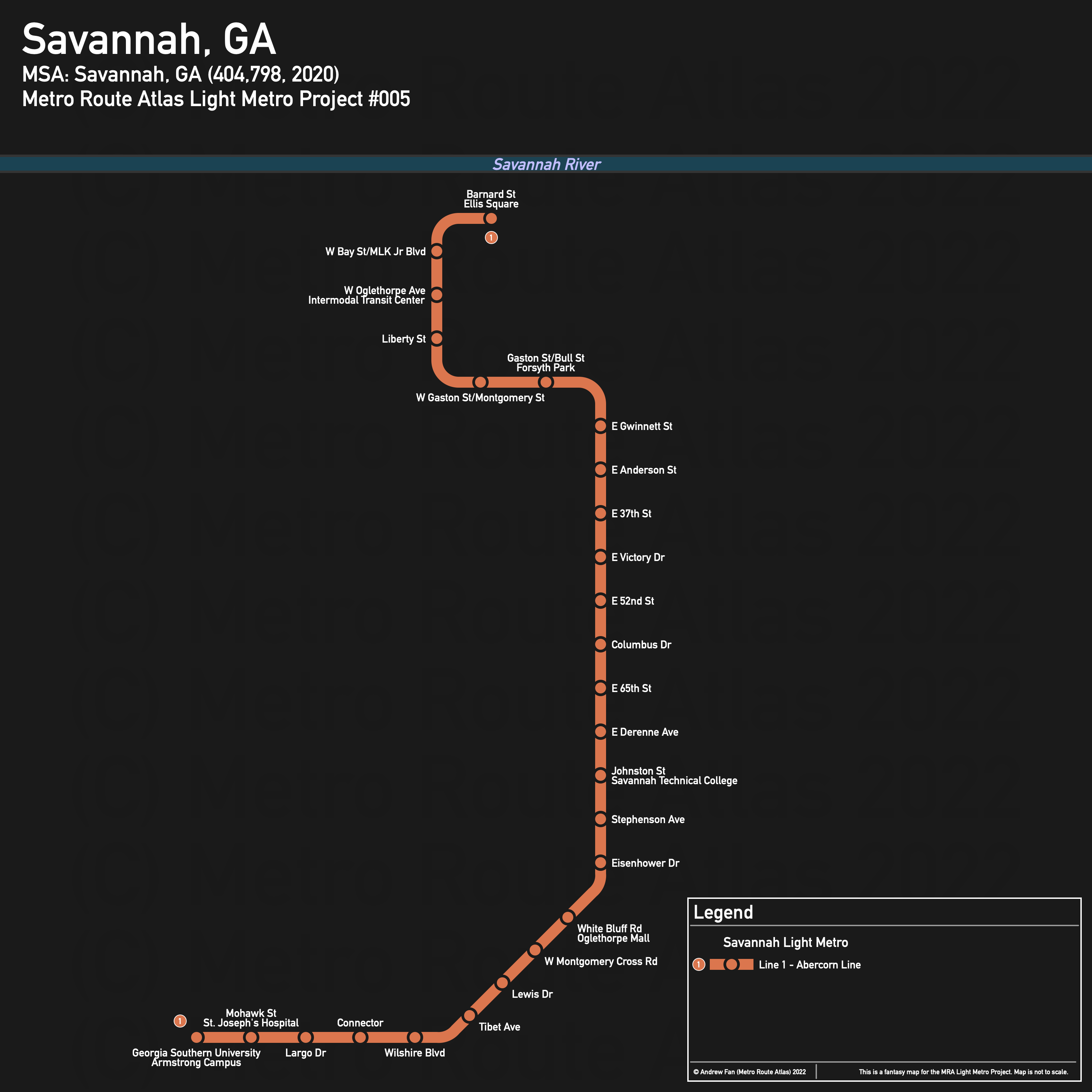
Table of Contents
Overview - Savannah
Located on the Savannah River and close to the Atlantic Ocean, Savannah is the seat of Chatham County and the fifth largest city by population in Georgia. It has approximately 147,780 inhabitants in the city proper as of 2020. The Savannah metropolitan area comprised 404,798 residents as of the 2020 US Census.
As of 2020, the main non-government employers in Savannah included St. Joseph's Candler, Memorial University Medical Center, Georgia Southern University, and Gulfstream Aerospace Corporation. Ft. Stewart/Hunter Army Airfield is another major employer . Main universities include the Georgia Southern University Armstrong Campus, Savannah College of Arts and Design, Savannah State University, and South University. The main airport is Savannah/Hilton Head International Airport. Notable stadiums include Grayson Stadium, as well as the Tiger Arena and Ted Wright Stadiums on the Savannah State University campus.
Savannah is bordered to the north by the river, to the east by marshes, and to the west by Highway 17 as well as railroads and I-516. With the exception of I-16's entry ramps, the historic city center has been spared from large freeways.
Major east-west roads include the Bay St/President St corridor, Oglethorpe Ave, Louisville Rd/Liberty St, Gwinnett St, Victory Dr, I-516/Derenne Ave, and Montgomery Cross Rd. Major north-south roads include MLK Jr. Blvd, Bull St/White Bluff Rd, Abercorn St, Waters Ave, and Skidaway Rd.
The local public transit agency in Savannah is Chatham Area Transit (CAT) (System Map (November 2019)), which operates a hub-and-spoke radial bus network out of the The Joe Murray Rivers Jr Intermodal Transit Center (which also serves intercity buses) located on W Oglethorpe Ave.
Below statistics are as of January 25, 2022:
- Bus routes running every [0, 10] minutes during weekday off-peak: None
- Bus routes running every (10, 15] minutes during weekday off-peak: None
- Bus routes running every (15, 30] minutes during weekday off-peak: 14, dot
2020 Census Tract Data suggests that most of the density is in the historic downtown core.
Network Design - Thought Process
Savannah has a MSA population of 404,798 and therefore has 81 points to spend (1 point for 1 km regional rail and 5 points for 1 km light metro/new build regional rail).
First thing's first - the railways in Savannah are not worth considering for regional rail. One corridor cuts across the city but goes nowhere, while nearly every other line avoids the parts of the city that have a high density of places people live and want to go. To this end, it's also worth mentioning that the Amtrak station is located in the middle of nowhere and does not get enough trains to warrant serving with higher order transit at this time. The Airport is a similar story since the passenger terminal is on the northwest side, making it difficult to access.
We are left with 16.2 km of light metro. And so our first order of business will be the Abercorn corridor, which sees the highest frequency of any bus in the network and which, with some deviations, can hit the vast majority of attractions in Savannah in one go. We start at Middleground Rd at the Georgia Southern University Armstrong Campus, and follow Abercorn north to Gaston St. Unlike with a surface bus, running a massive elevated concrete guideway above Savannah's beautiful historic plazas is an awful idea, and we want to hit destinations on the west side of the historic city regardless, so we will turn off of Abercorn instead of continuing on it. The corridor turns west and runs to MLK Jr. Blvd, where it turns north and runs to Bay St. From here, we have almost nothing left to spend, so for now we opt to run east to Barnard St, which completes our only line. If we had more, crossing the river to the convention center would also be an option.
Unfortunately, Savannah's MSA population is not big enough for another line using our point system. As a result, we cannot serve the Derenne Ave corridor (Candler Hospital, Memorial Health University Medical Center, Savannah State University). A second line would want to serve these areas. That being said, our current line does serve Georgia Southern University's Armstrong Campus, St. Joseph's Hospital, Savannah Technical College, Forsyth Park (and the SCAD campus there), and the Savannah Historic District (and the SCAD campus there). It is a block from the Intermodal Transit Center.
Savannah Light Metro
The Savannah Light Metro consists of a single north-south corridor.
Line 1 - Abercorn Line
Line 1 of the Savannah Light Metro is a 16.2 km light metro service on a North-South alignment. It runs from Georgia Southern University Armstrong Campus in the south to Barnard St in the north, serving 26 stations primarily along Abercorn Rd, Gaston St, and MLK Jr Blvd.
The line has an average station spacing of 648 meters. Some stops in downtown are close together due to high destination density.
The line is named after the corridor served. The line color is from the Visit Savannah website's Georgia peach banner CSS.
Realistic Applications
This project actually looks like it might be possible in the future assuming continued growth in the Savannah area. NIMBYism aside (and the need to tunnel under the denser residential areas to avoid local opposition), Abercorn really is a good corridor as far as Savannah is concerned. If they can run a bus every 10 minutes or some kind of Arterial BRT service, I wouldn't be surprised if ridership grew enough to support a light metro style service.
References & Helpful Links
External Citations