Curitiba, Paraná, Brazil
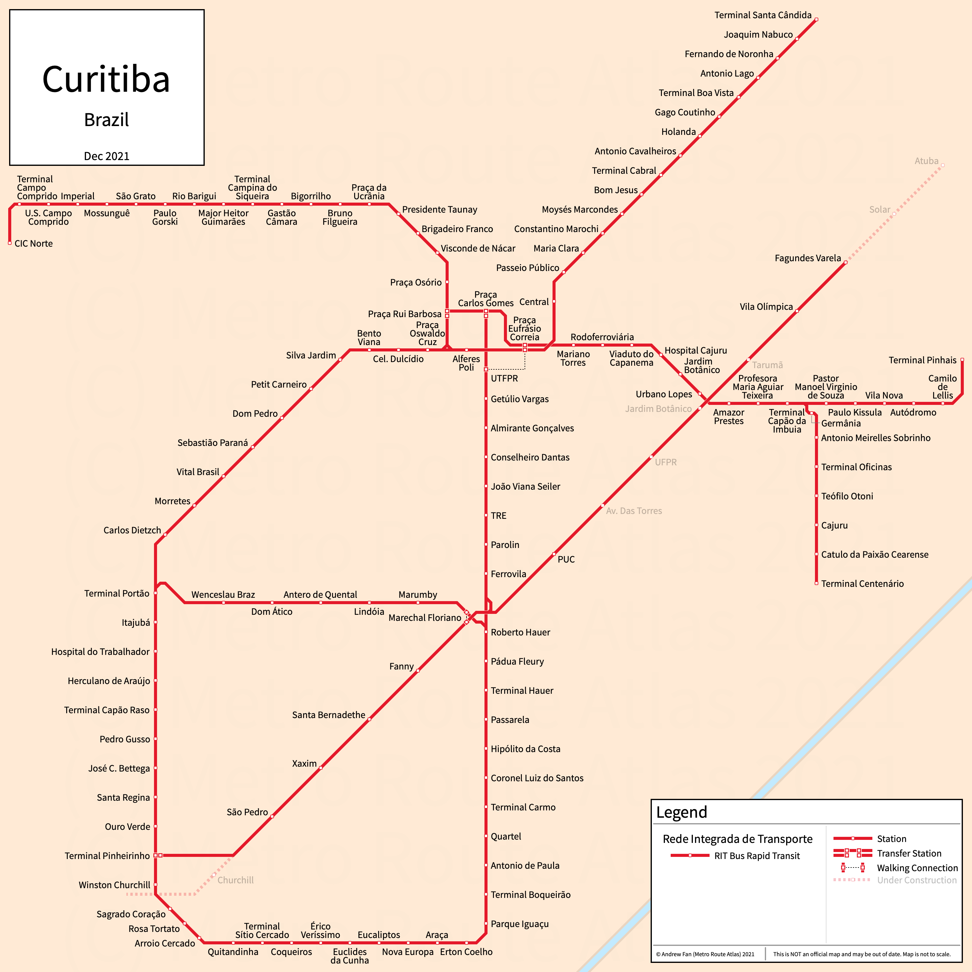
Table of Contents
Overview - Curitiba
Curitiba is the capital of and largest city by population in Paraná. It has approximately 1,774,000 inhabitants in the city proper as of 2022. The Curitiba metropolitan area comprised 3,382,210 residents as of the 2022 IBGE census estimate.
Curitiba's rapid transit network consists of seven bus rapid transit lines.
Rede Integrada de Transporte (RIT)
Opened 1974 with major upgrades in 1991, the RIT consists of seven bus rapid transit lines that serve the city of Curitiba, Paraná and the surrounding suburbs.
North (Norte)
The North corridor of the RIT is a bus rapid transit line on a north-south alignment. It runs from Praça Eufrásio Correia in the south to Terminal Santa Cândida in the north, serving 16 stations. The primary services are 203 and 250 (Ligeirão), which both through-operate into the South corridor.
The North corridor was opened in 1974 and converted to bus rapid transit in 1991.
South (Sul)
The South corridor of the RIT is a bus rapid transit line on a north-south alignment. It runs from Termianl Pinheirinho in the south to Praça Eufrásio Correia and Rui Barbosa in the north, serving 22 stations. The primary services are 203 and 250 (Ligeirão), which both through-operate into the North corridor, and 603, which serves Rui Barbosa. The Circular Sul loop services run on this corridor as well.
The South corridor was opened in 1974 and converted to bus rapid transit in 1991.
Boqueirão
The Boqueirão corridor of the RIT is a bus rapid transit line on a north-south alignment. It runs from Terminal Boqueirão in the south to Praça Carlos Gomes in the north, serving 19 stations. The primary services are 500 (Ligeirão), 503, and 550 (Ligeirão), which through-operates onto the Verde corridor. The Circular Sul loop services run on this corridor as well, as does Linha Verde express services.
The Boqueirão corridor was opened in 1977 and converted to bus rapid transit in 1991.
East (Leste)
The East corridor of the RIT is a bus rapid transit line on an east-west alignment. It runs from Praça Rui Barbosa in the west to Terminal Pinhais and Terminal Centenário in the east, serving 24 stations. The primary services as C01 (Terminal Pinhais branch, formerly 301), 302 (Terminal Centenário branch), and 303 (Terminal Centenário branch), which through-operates into the West corridor. Services run through but bypass stations at Praça Carlos Gomes (westbound, Boqueirão platforms) and Alferes Poli (eastbound, North/South platforms)
The East corridor was opened in 1980 and converted to bus rapid transit in 1991.
West (Oeste)
The West corridor of the RIT is a bus rapid transit line on an east-west alignment. It runs from CIC Norte in the west to Praça Rui Barbosa in the east, serving 20 stations. The primary service is 303, which through-operates into the East corridor.
The West corridor was opened in 1980 and converted to bus rapid transit in 1991.
South Circular (Circular Sul)
The South Circular corridor of the RIT is a bus rapid transit line on a loop alignment. It connects the West and Boqueirão corridors, serving 20 stations not on the other lines. The primary services are 502 (clockwise) and 602 (counterclockwise), which through-operate into the South and Boqueirão corridors to complete the loop.
The South Circular corridor was opened in 1999.
Green Line (Linha Verde)
The Green Line corridor of the RIT is a bus rapid transit line on a southwest-northeast alignment. It runs from Terminal Pinheirinho in the southwest to Terminal Atuba in the northeast, serving 14 stations. The primary services are 350 (Ligeirão) and 550 (Ligeirão), which through-operates onto the Boqueirão corridor.
The Green Line was opened in 2009 and the last expansion to the line was the opening of UFPR in March 2025.
References & Helpful Links
Rede Integrada de Transporte at Wikipedia | Rede Integrada de Transporte at Wikipedia.pt
Official Website for RIT: Rede Integrada de Transporte
Maps
Official System Map - RIT [PDF] [Last Accessed Nov 27, 2021]
Other Sources
Curitiba, Brazil at BRTDATA.org
Other Websites
External Citations
Asset Notes
Line and icon colors taken from official map as of November 27, 2021.