Chattanooga, Tennessee, USA
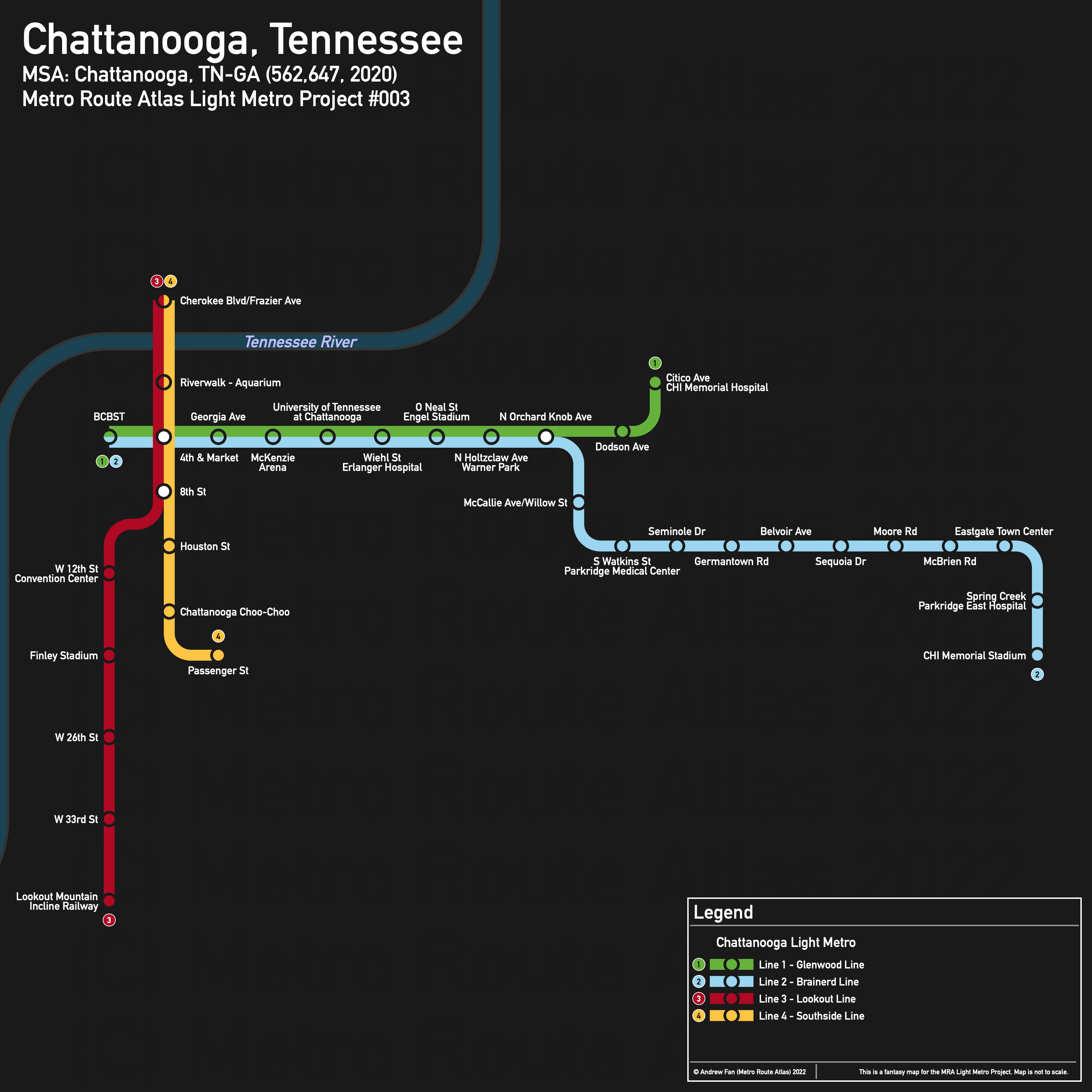
Table of Contents
Overview - Chattanooga
Located on the Tennessee River, Chattanooga is the seat of Hamilton County and the fourth largest city by population in Tennessee. It has approximately 181,099 inhabitants in the city proper as of 2020. The Chattanooga metropolitan area comprised 562,647 residents as of the 2020 US Census.
As of 2020, the main non-government employers in Chattanooga included BlueCross BlueShield of Tennessee, Erlanger Health System, CHI Memorial, Tennessee Valley Authority, Volkswagen Group of America, and McKee Foods Corporation . Main universities include the University of Tennessee at Chattanooga. The main airport is Chattanooga Metropolitan Airport. Notable stadiums include Finley Stadium and CHI Memorial Stadium (technically not in the city). Within the Metropolitan Area, notable employment sites and universities include Southern Adventist University in Collegedale.
Chattanooga is sandwiched between a ridge and the Tennessee River. I-24 skirts the city core and runs east-west. US-27 runs adjacent to downtown, cutting it off from the industrialized waterfront on the west side as well as the BlueCross BlueShield of Tennessee Headquarters. Freight railroads slice through the city, with the Norfolk Southern DeButts Yard taking up a large area east of downtown and additional yard also present in the city. None of the rail corridors provide a reliable route into downtown, though one former ROW reaches Finley Stadium and gets tantalizingly close to Downtown (note that the Chattanooga Choo-Choo Hotel/Terminal Station building itself is no longer usable as a building has been erected in the approach ROW).
Going east-west, East 3rd/4th Streets, McCallie Ave, MLK Blvd, and East Main St are the main road corridors. Going north-south, Broad and Market Streets are the primary corridors. Central Ave and Holtzclaw Ave also run north-south outside of downtown.
The local public transit agency in Chattanooga is Chattanooga Area Regional Transportation Authority (CARTA) (System Map (Oct 2021)). It operates a hub and spoke system based out of the Market St and 3rd/4th St corridors in downtown, a well as the Lookout Mountain Incline Railway.
Below statistics are as of the October 2021 timetable:
- Bus routes running every [0, 10] minutes during weekday off-peak: None
- Bus routes running every (10, 15] minutes during weekday off-peak: None
- Bus routes running every (15, 30] minutes during weekday off-peak: 1, 4
2020 Census Tract Data suggests that most of the density is directly east of downtown in the university area, with most other density on the immediate north side of the river and in the south and east of the city.
Network Design - Thought Process
Chattanooga has a MSA population of 562,647 and therefore has 113 points to spend (1 point for 1 km regional rail and 5 points for 1 km light metro/new build regional rail).
First, it is worth mentioning the railways. They are exclusively used for freight and do not pass through the city center. However, the Southern Adventist University and airport are directly next to railway corridors. Unfortunately, the route from the airport is... circuitous, and Southern Adventist University is quite a ways away, meaning that the actual distance counts against the service due to the anchor not having much more than the university. The real issue here is that although circuitous, the rail corridors simply do not have enough near or around them to be viable. For the cost of the regional rail lines, despite our point system giving them a major advantage, it would be possible to build an additional cross-city metro line or significantly extend another.
So our attention shifts to the metro network. Going east-west, we have a choice of three corridors - East 3rd/4th St, McCallie Ave, and MLK Blvd. East 3rd St has far more destinations along it, while McCallie has a better catchment area. Both have most of the University of Tennessee at Chattanooga in walking distance. In order to get as much as possible, we suggest an east-west corridor that roughly follows the East 3rd/4th St corridor but which deviates a bit. Starting at the service road immediately to the east of the BlueCross BlueShield HQ, we start, going straight across the highway and down 4th St. At Mabel St, the route take Mocs Alumni Dr in order to have a catchment area close to the campus. The route curves north on Palmetto St and then turns east on East 3rd St to serve Erlanger Hospital, Engel Stadium, and the Zoo at Warner Park. When it intersects Derby St, it turns north, ending at Citico Ave at the CHI Memorial Hospital. This route is 5.8 km and costs 29 points of our 113 points.
Now let's get a north-south route. I personally feel that the Lookout Mountain Incline Railway is a good starting point, and starting at the intersection of St Elmo Ave and Tennessee Ave, the route takes Tennessee Ave up to Broad St, and then follows Broad St up to W 20th St. In order to serve both Finley Stadium and the Convention Center, we take Reggie White Blvd/Carter St north to MLK Blvd, then take it over to Market St in order to continue north across the river. On the North Shore, catchment areas are smaller due to more rugged terrain and lower density. The distance to Frazier Ave is 6.7 km and costs 33.5 points.
In order to hit most of the density, there are some options for extensions and branches. Of these, the Brainerd Rd corridor is served by the most frequent bus in the CARTA network and technically reaches out to both the airport and Hamilton Place mall. Branching out from our east-west route at Willow St, our new branch runs from E 3rd St down to McCallie Ave, then east down Brainerd Rd. It is 6.2 km to Spring Creek Rd, at which point we need to determine if we want to aim for the airport or CHI Memorial Stadium. Regardless, we will have a station at Eastgate Town Center so that it can be used as a Park and Ride/transfer location for shuttles to the destination we choose not to serve. From here it is 4.2 km to the airport terminal, meaning that we would have used 115 points and burned through the entirety of our remaining points for the project in order to serve the 122nd busiest airport in the USA as of 2019 when it's already in an airport shuttle distance from the line we've built. If we want to go to the stadium instead, we can jog east and serve Eastgate Town Center first. Now, while we could just use the highway and serve the stadium, there's more benefit if we serve the Parkridge East complex, which will have less seasonal/bursty ridership. Doing a jig back to Spring Creek Rd at I-24 and then using N Mack Smith Rd, it takes us an additional 2.5 km to get to the stadium. The stadium itself has burst traffic, which may make it less competitive than the airport route, but there is also space for operations and maintenance facilities, transit centers/transfer stations, etc. For this reason, the stadium route is preferred over the airport.
With this, we have 7 points remaining, or 1.4 km of light metro. On our North-South line at MLK Blvd and Market St, this is enough to take us down to Main St and east to Passenger St, allowing us to serve the core of the Southside Historic District.
And so we have a two line light metro network with branches on both lines, intersecting in downtown.
Chattanooga Light Metro
The Chattanooga Light Metro consists of two light metro lines with two branches each, resulting in four services. In standard US fashion, we will brand the branches separately as different lines. Lines 1 and 2 use the east-west line, while Lines 3 and 4 use the north-south line.
Line 1 - Glenwood Line
Line 1 of the Chattanooga Light Metro is a 5.8 km light metro service on an East-West alignment. It runs from BCBST in the west to CHI Memorial Hospital in the east via the University of Tennessee at Chattanooga, serving 11 stations.
The line has an average station spacing of 580 meters, as it is primarily a local route serving fairly closely spaced destinations.
The line is named after the neighborhood at its eastern terminus. The line color is taken from the Glenwood Neighborhood Association Logo as of January 2022.
Line 2 - Brainerd Line
Line 2 of the Chattanooga Light Metro is a 13.5 km light metro service on an East-West alignment. It runs from BCBST in the west to CHI Memorial Stadium in the east via the University of Tennessee at Chattanooga, serving 20 stations.
The line has an average station spacing of 711 meters.
The line is named after the road it runs on after the ridge. The line color is taken from the sky on the Chattanooga City Flag.
Line 3 - Lookout Line
Line 3 of the Chattanooga Light Metro is a 6.7 km light metro service on a North-South alignment. It runs from Cherokee Blvd/Frazier Ave in the north to the Lookout Mountain Incline Railway in the south, serving 9 stations.
The line has an average station spacing of 838 meters, mainly due to longer distances between stations outside of downtown.
The line is named after Lookout Mountain. The line color is taken from the Lookout Mountain Incline Railway 125th Anniversary logo.
Line 4 - Southside Line
Line 4 of the Chattanooga Light Metro is a 3.3 km light metro service on a North-South alignment. It runs from Cherokee Blvd/Frazier Ave in the north to Passenger St in the south, serving 7 stations.
The line has an average station spacing of 550 meters. Like Line 1, it is a primarily local service.
The line is named after the district which it serves and terminates in. The line color is taken from the gold in the Chattanooga City Flag.
Realistic Applications
From any realistic standpoint, Chattanooga's geography makes this proposal simultaneously impractical and practical - from a current day perspective, the network effect is absolutely required for any line to be useful since no single corridor seems to be truly self sustaining on its own, but geographic constraints will drive further growth on the west side of the ridge if zoning allows for it. From river to ridge, it is simultaneously too long to walk and too short to support a metro service given current densities. Without the university, no line in the city would be practical, but the university is already in walking distance of nearly every attraction in downtown, meaning that there wouldn't be an incentive to even use the light metro most of the time.
What this does mean is that perhaps such a proposal is doomed to failure today, but depending on how the city chooses to grow in the future, such a project could be essential to keep congestion in check through the many bottlenecks connecting the main residential areas to the city core and destinations within.
References & Helpful Links
External Citations