Salt Lake City, Utah, USA
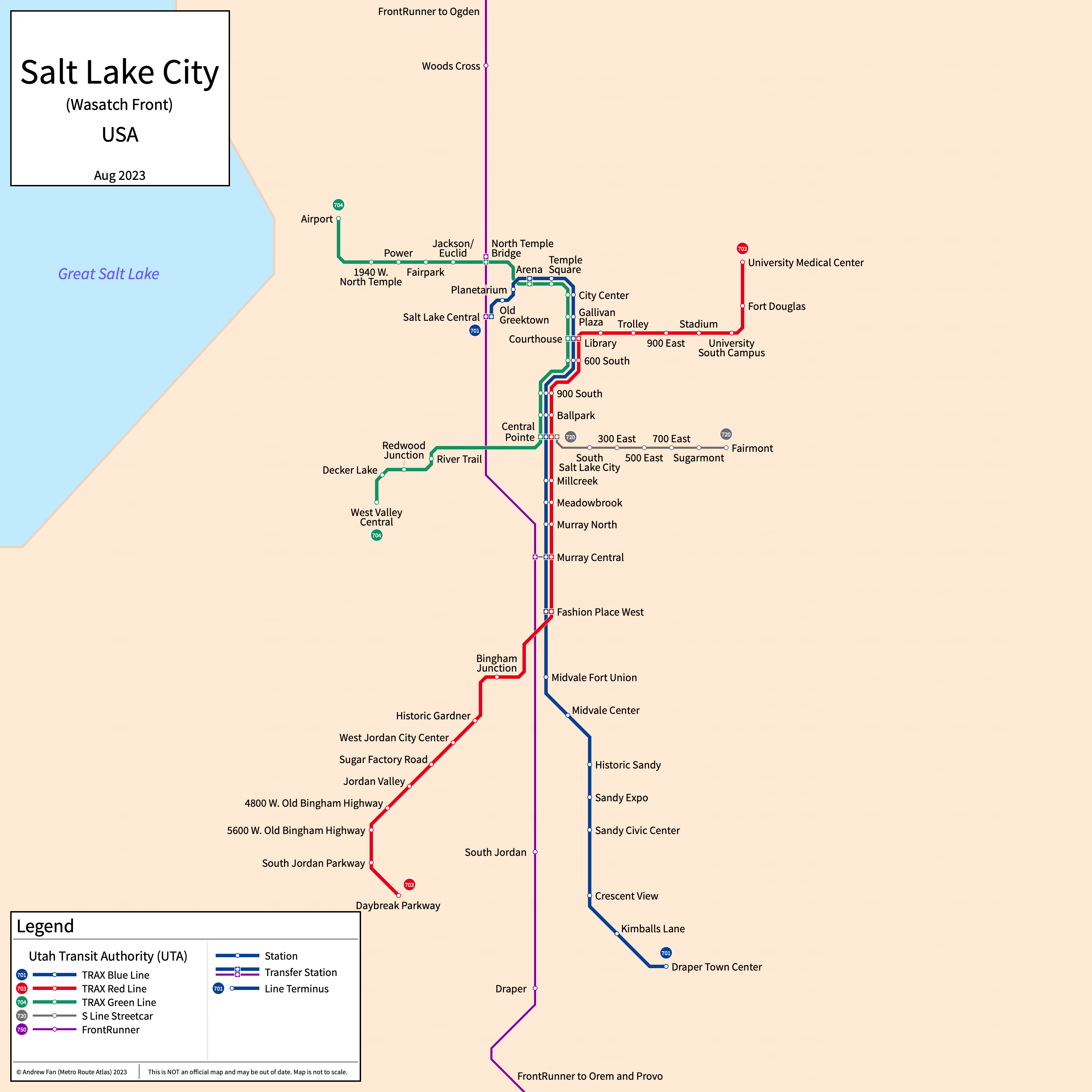
Table of Contents
Overview - Salt Lake City
Located southeast of the Great Salt Lake, Salt Lake City is the capital and largest city by population in Utah. It has approximately 210,000 inhabitants in the city proper as of 2023. The Salt Lake City metropolitan area (Salt Lake City-Murray) comprised 1,267,864 residents as of the 2023 US Census Bureau Estimate.
The Wasatch Front's rapid transit network consists of three light rail services. It also has a modern streetcar service, a BRT-Lite service, and a commuter rail service.
TRAX Light Rail
Opened 1999, the Transit Express (TRAX) consists of three light rail services that serve the city of Salt Lake City, Utah and the nearby suburbs.
TRAX Blue Line (701)
The Blue Line is a light rail service with 25 stations on a North-South alignment, running from Salt Lake Central in the north to Draper Town Center in the south via downtown Salt Lake City.
The Blue Line was opened in December 1999 and the last expansion to the line was the opening of 600 South in July 2022. The Blue Line is owned and operated by the Utah Transportation Authority.
| Service | M-F Midday | M-F Rush | Sat. | Sun. | Notes |
|---|---|---|---|---|---|
| Blue | 15' | 15' | 15' | 30' |
Schedules -- Last Updated: Apr 30, 2026
TRAX Red Line (703)
The Red Line is a light rail service with 27 stations on a North-South alignment, running from University Medical Center in the north to Daybreak Parkway in the south via downtown Salt Lake City.
The Red Line was opened in December 2001 and the last expansion to the line was the opening of South Jordan Downtown in March 2025. The Red Line is owned and operated by the Utah Transportation Authority.
| Service | M-F Midday | M-F Rush | Sat. | Sun. | Notes |
|---|---|---|---|---|---|
| Red | 15' | 15' | 15' | 30' |
Schedules -- Last Updated: Apr 30, 2026
TRAX Green Line (704)
The Green Line is a light rail service with 19 stations on a North-South alignment, running from Salt Lake City International Airport in the north to West Valley Central in the south via downtown Salt Lake City.
The Green Line was opened in August 2011 and the last expansion to the line was the opening of 600 South in July 2022. The Green Line is owned and operated by the Utah Transportation Authority.
| Service | M-F Midday | M-F Rush | Sat. | Sun. | Notes |
|---|---|---|---|---|---|
| Green | 15' | 15' | 15' | 30' |
Schedules -- Last Updated: Apr 30, 2026
S Line
Opened December 2013, the S-Line is a modern streetcar service serving the eastern part of Salt Lake City.
S-Line (720)
The S-Line is a modern streetcar service with an east to west alignment, running along a former disused railway right of way in Salt Lake City. It runs from Central Pointe in the west to Fairmont in the east and serves 7 stops.
The S-Line was opened in December 2013. The S-Line is operated by the Utah Transportation Authority.
| Service | M-F Midday | M-F Rush | Sat. | Sun. | Notes |
|---|---|---|---|---|---|
| S-Line | 15' | 15' | 15' | 30' |
Schedules -- Last Updated: Apr 30, 2026
MAX
Opened July 2008, the MAX is a bus rapid transit network serving the Wasatch Front. For MAX in the Provo-Orem area, see Provo-Orem Page. For MAX in the Provo-Orem area, see Ogden Page.
Midvalley Express (50X)
The Midvalley Express is a BRT-Lite service on a northwest-southeast alignment, running from West Valley Central in the northwest to Murray Central in the southeast and serving 15 stations. It runs in a dedicated busway along 4500 South, with the remainder of the line in mixed traffic.
The Midvalley Express was opened in April 2026. The Midvalley Express is operated by the Utah Transportation Authority.
| Service | M-F Midday | M-F Rush | Sat. | Sun. | Notes |
|---|---|---|---|---|---|
| MVX 50X | 15' | 15' | 15' | 30' |
Schedules -- Last Updated: Apr 30, 2026
FrontRunner
Opened April 2008, the FrontRunner is a commuter rail service serving the cities of the Wasatch Front in Utah.
FrontRunner (750)
The FrontRunner is a commuter rail service with a north to south alignment. It runs from Ogden in the north to Provo in the south and serves 18 stations. It formerly ran farther north to Pleasant View but service was cut back to Ogden in August 2018 due to signaling costs.
The FrontRunner was opened in April 2008 and the last expansion was the opening of Vineyard in August 2022. The FrontRunner is operated by the Utah Transportation Authority.
| Service | M-F Midday | M-F Rush | Sat. | Sun. | Notes |
|---|---|---|---|---|---|
| FrontRunner | 60' | 30' | 60' | No Service |
Schedules -- Last Updated: Apr 30, 2026
References & Helpful Links
Official Website for TRAX Light Rail, FrontRunner, and MAX: Utah Transportation Authority (UTA)
Official Website for S-Line: Sugar House Streetcar
Maps
All Official Maps - Utah Transit Authority [Last Accessed Apr 30, 2026]
Official System Map - UTA Rail & BRT [Last Accessed Apr 30, 2026]
Unofficial Map - UTA Rail and BRT Diagram [August 2023] by Cameron Booth (transitmap.net)
Unofficial Map - Salt Lake City [December 2020] by Jug Cerovic (www.inat.fr)
Other Sources
Salt Lake City, USA at Urbanrail.net
Asset Notes
Rail Line colors taken from UTA schedule page in Feb 2019.
MVX Line color taken from UVX map/timetable in April 2019.