Wichita, Kansas, USA
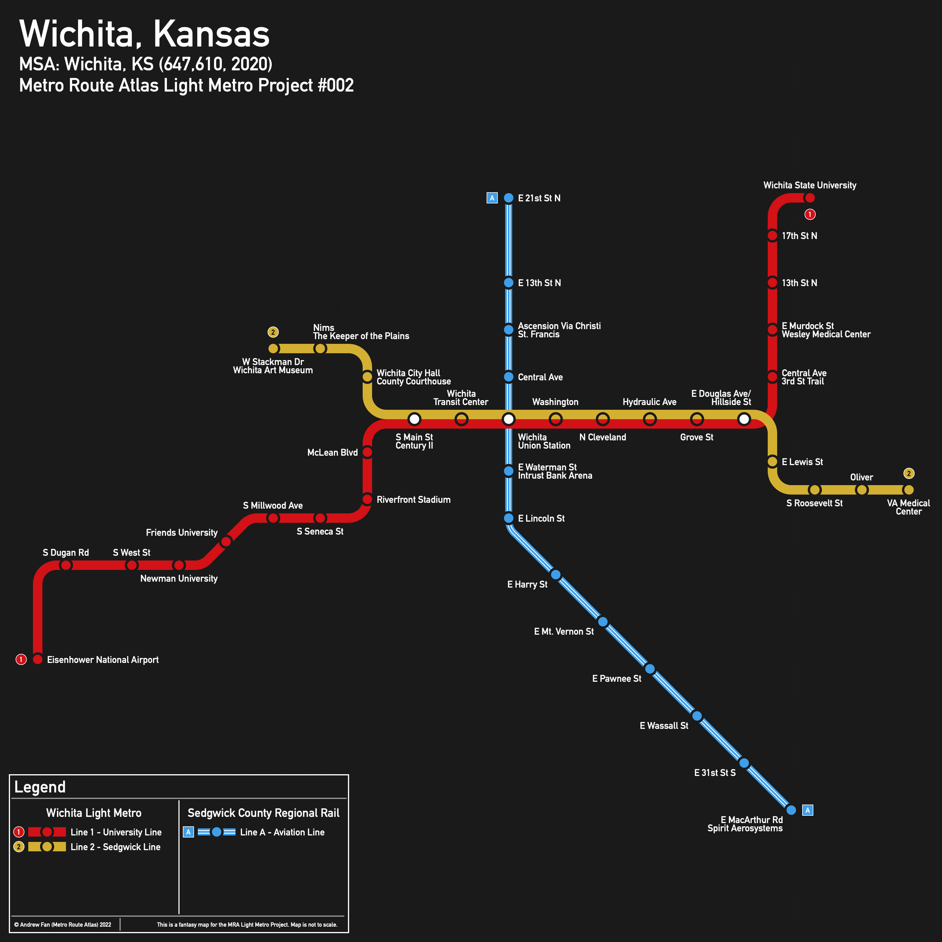
Table of Contents
Overview - Wichita
Located on the Arkansas River, Wichita is the seat of Sedgwick County and the largest city by population in Kansas. It has approximately 397,532 inhabitants in the city proper as of 2020. The Wichita metropolitan area comprised 647,610 residents as of the 2020 US Census.
According to the Greater Wichita Partnership, the main non-government employers in Wichita include Spirit AeroSystems, Textron Aviation, Ascension Via Christi, Koch Industries, and Wichita State University, with McConnell Air Force Base also a major employment center . Main universities in Wichita include Wichita State University, Friends University, Newman University, and WSU Tech. The main airport is Wichita Dwight D. Eisenhower National Airport. INTRUST Bank Arena is the main stadium in Wichita.
Wichita is notable for having a railroad ROW running straight north-south through downtown, resulting in a long, straight industrial corridor. I-135 runs north-south east of downtown, with highway 400 running east-west south of downtown. The Arkansas River runs north-south west of downtown.
In the downtown area, Douglas and Central Avenues run east west as the primary bidirectional corridors. Running north-south, Broadway and Mosley/Washington are the primary corridors. Multiple rail corridors split out from the core corridor running north-south, including along Southeast Blvd to the Air Force Base.
The local public transit agency in Wichita is Wichita Transit (System Map (Jan 2022)). It operates a hub and spoke system based out of the Wichita Transit Center in downtown.
Below statistics are as of the January 2022 timetable:
- Bus routes running every [0, 10] minutes during weekday off-peak: None
- Bus routes running every (10, 15] minutes during weekday off-peak: Q
- Bus routes running every (15, 30] minutes during weekday off-peak: None
2020 Census Tract Data suggests that most of the density is spread out around the city.
Network Design - Thought Process
Wichita has a MSA population of 647,610 and therefore has 130 points to spend (1 point for 1 km regional rail and 5 points for 1 km light metro/new build regional rail).
The first thing to note is that there is a west-northeast corridor from the airport to WSU that hits all four universities, the downtown (including the transit center/intercity bus terminal and INTRUST Bank Arena), and the Wesley Medical Center. In terms of destinations, this corridor is simply too good to ignore. Starting at the Wichita Airport terminal and going north to US 400/W Kellogg Dr, it follows the road east to Newman University, where it uses the railway corridor past Friends University to W Maple St. Here it goes east to Riverfront Stadium, goes north to Douglas Ave, and crosses the river. An alternative would be to take the railway corridor up to Douglas Ave and go east, but that misses the stadium and the rail corridor limits the catchment area of the stations. In downtown, the line deviates from Douglas down Century II Dr to E William St to serve the transit center and INTRUST Bank Arena, then turns up S Emporia St to return to E Douglas Ave. From here the line takes E Douglas to Hillside St and takes it north past the Wesley Medical Center to Wichita State University, where it crosses the parking lots to arrive at the bus loop off of Alumni Dr, close to Shocker Hall and the Charles Koch Arena. This entire route is approximately 18.3 km, with adjustment based off curves. This light metro line wipes out 91.5 of our 130 points, leaving us with 38.5 points left.
Now, turning our attention to that north-south rail corridor, the only real anchor in the north is Ascension Via Christi St. Francis, with 21st St being as far as the route can easily go before density around the corridor falls off. It is 1.5 km from Douglas to the medical center and 4.2 km from Douglas to 21st St. More problematic is the southeastern portion - the Air Force Base, Spirit Aerosystems plants, museums, and other points of interest here are all very spread out. South of MacArthur Rd, the population and job density likely does not justify service at all and everything is very car dependent (and therefore difficult to serve with transit). For this reason, we suggest terminating the service here, with companies operating shuttles to and from the station for their employees and, as much as I am loathe to admit it, building a park & ride (there are much better locations along the corridor for transit oriented development. The section of the ROW from Douglas Ave to MacArthur Rd is 8 km long.
Looking at other rail corridors, the Orient Blvd corridor in the southwest has S Meridian Ave as a natural end point for where it can be useful. From S Gilbert (junction with the other corridor) to S Meridian Ave, it is around 4.3 km, but the residential and commercial density on the corridor is very low. With no real destinations down the route, this corridor isn't very competitive without good feeder services. The Zoo Blvd corridor in the northwest might be competitive, but the portion heading towards downtown has already been sold off and the ROW is no longer usable due to development. While it could still connect to our west-northeast light metro corridor, doing so by staying within the ROW is not time competitive and significantly hurts the service. Extending it along the former ROW is also an option but there isn't a good location for a direct transfer station - the best option is to terminate it between Sycamore St and McLean Blvd. Assuming we actually terminate it at the zoo, it's about 400m to the ROW, then 5.1 km along the existing ROW (to Millwood), then 1.3 km of restored ROW to its terminus, resulting in 6.8 km of which 1.7 km is new build (total of 13.6 points).
There are a few light metro corridors that can be considered. One is branching the line we currently have at Douglas and Hillside, and sending the line south to the highway, then east. The VA Medical Center is 2.8 km (14 points) from the junction, while the Towne East Square Mall is 5.2 km (26 points) from the junction. Due to commuting patterns, the mall's parking lot could double as a massive free park & ride for the area, though given the collapse of brick and mortar retail as it moves online, it would be more useful as a mixed use residential and commercial destination.
Another possible corridor is a line along the Central Ave corridor, through the museum district, running down to the existing corridor. There are two ways to handle this line - one is as an independent line and one is as a branch. If it is independent we want it to have a transfer to the regional rail line, and the portion of the line used for the transfer with the existing line counts as extra trackage. Assuming it starts at a transfer point at Waterman and the rail ROW, then uses Emporia to reach the transit center, it would require around 500m (2.5 points) to provide a soviet triangle style transfer. From here, there are options. If the line turns north on Broadway and west on Central, it is 3 km (15 points) to West Stackman and Museum Blvd, 4.5 km (22.5 points) to Meridian and Central on the other side of the river, and 6.1 km (30.5 points) to West St, all including the extra trackage for the duplicated portion shared with the initial line. Unfortunately, in order to have any significant trackage on this corridor, we would need to cut service elsewhere. In addition, the museum district on its own is not the strongest anchor, and although far, Central Ave does parallel the west-northeast corridor we already have. Turning the service into a branch of the original line using N Water St and Veterans Pkwy is 2 km from the existing line to West Stackman and Museum Blvd (10 points) but considerably reduces the catchment area of the line. Turning the service into a branch using the same alignment as the independent line discussed earlier requires around 2.8 km (14 points). Using N Water St and Central Ave (turning at City Hall) requires 2.3 km (11.5 points).
While there are always many more corridors, alignments, and other options we could consider, we will stop here. We definitely want our initial line from the airport to Wichita State University via the Transit Center. We will also take the full 12.2 km 21st St-MacArthur Rd existing ROW. Neither of the two other existing ROW options are very good, so we will skip them and instead take the VA Medical Center (2.8 km) branch and the Museum branch via City Hall alternative (2.3 km). This gives us a total of 129.2 out of 130 points, and leaves us with a 23.4 km light metro line including branches on both ends and a 12.2 km regional rail line. This network is hard carried by the main light metro corridor, with other services primarily adding additional destinations and riders via the network effect. It does manage to serve the airport, three university campuses, the main transit center, three medical centers, and multiple stadiums.
Wichita Light Metro
The Wichita Light Metro consists of two interlined services. The Kellogg, Douglas, Maple, and Hillside corridors are the primary corridors used by the network. Interchange is provided with regional rail services at Union Station.
Line 1 - University Line
Line 1 of the Wichita Light Metro is a 18.3 km light metro service on a Northeast-West alignment. It runs from Eisenhower National Airport in the west to Wichita State University in the northeast via Wichita Transit Center, serving 22 stations.
The line has an average station spacing of 871 meters, skewed by very long distances between stations in the west.
The line is named after the fact that it connects the major universities of the city. The color of the line is taken from the Flag of Wichita
Line 2 - Sedgwick Line
Line 2 of the Wichita Light Metro is a 8.9 km light metro service on an east-west alignment. It runs from W Stackman Dr in the west to the VA Medical Center in the east via Wichita Transit Center, serving 15 stations.
The line has an average station spacing of 636 meters.
The line is named after the county. The color of the line is taken from the Logo of the City of Wichita.
Sedgwick County Regional Rail
Sedgwich County Regional Rail consists of a single service running entirely along an existing rail corridor within Wichita. Interchange with the Light Metro network is provided at Union Station.
Line A - Aviation Line
Line A of the Sedgwick County Regional Rail is a 12.2 km regional rail service on a North-South alignment. It runs from E 21 St in the north to E MacArthur Rd in the south, serving 13 stations.
The line has an average station spacing of 1.017 km. Stations are located at all major intersections - even at Wassall and 31st St - for coverage purposes and to support potential park and ride/transit oriented development.
The line is named after Wichita's history and current relationship with the aviation industry. The color of the line is taken from the Logo of the City of Wichita.
Realistic Applications
Put bluntly, given that Wichita is sprawling, fairly low density, and has almost no existing public transit, I highly doubt the kind of plans presented here are even remotely possible. That being said, assuming they boot up an arterial BRT service that approximates the route of Line 1 and run it for a decade or two, there may eventually be enough public support for the line to be built, though I highly doubt anything else proposed here is possible in the near future without some kind of political breakthrough.
It is worth mentioning that if any more railroad rights of way are abandoned, they should definitely be preserved and not built over, so as to not prevent future service from being built along the same corridor.
I do have to admit that the Museum branch is a little contrived. Such a branch would only truly be useful if it continued west along Central Ave (with a new bridge). That might be an opportunity for an enhanced transit service. But do note that I included it because it was the component that best fit into the existing network while providing the most flexibility (in order for me to get under the maximum amount of trackage allowed).
References & Helpful Links
External Citations