Calgary, Alberta, Canada
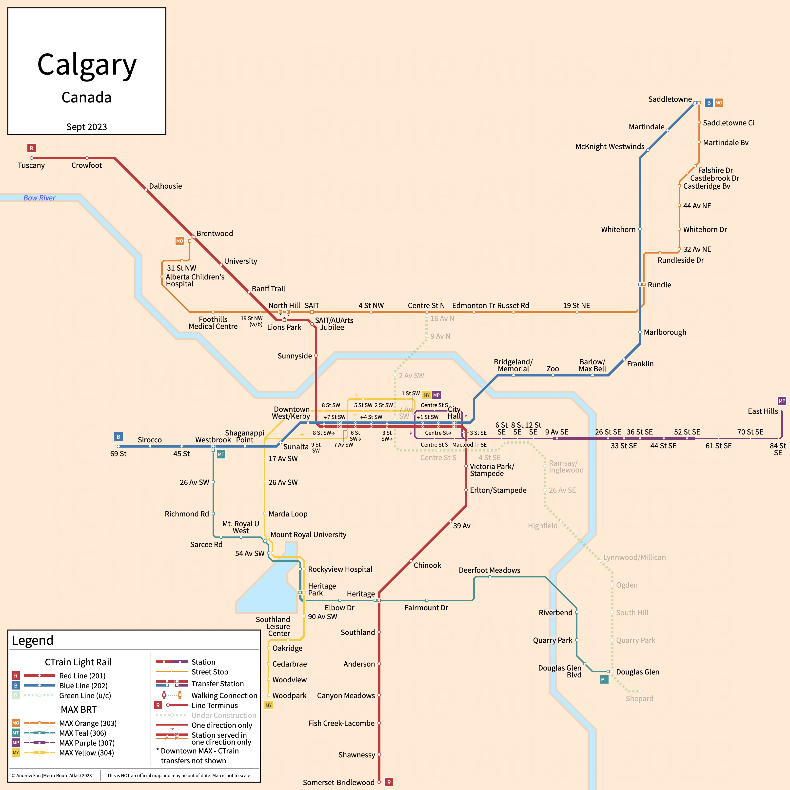
Table of Contents
Overview - Calgary
Located at the confluence of the Bow and Elbow Rivers, Calgary is the largest city by population in Alberta. It has approximately 1,414,000 inhabitants in the city proper as of 2022. The Calgary metropolitan area comprised 1,481,806 residents as of the Canada 2021 Census.
Calgary's rapid transit network consists of two light rail services and a bus rapid transit service. It also three arterial bus rapid transit services.
CTrain
Opened 1981, CTrain consists of two light rail services that serve the city of Calgary, Alberta and the surrounding suburbs.
CTrain Red Line
The CTrain Red Line is a light rail service on a Northwest-South alignment. It runs from Tuscany in the northwest to Somerset-Bridlewood in the south via Downtown Calgary, serving 28 stations of which 7 are in a single direction only and are shared with the Blue Line.
The Red Line was opened in May 1981 and the last extension to the line was to Somerset-Bridlewood in June 2004. The Red Line is owned and operated by Calgary Transit.
| Service | M-F Midday | M-F Rush | Sat. | Sun. | Notes |
|---|---|---|---|---|---|
| Red | 10-12' | 4-6' | 20' | 20' |
Schedules -- Last Updated: May 25, 2025
CTrain Blue Line
The CTrain Blue Line is a light rail service on a Northeast-West alignment. It runs from Saddletowne in the northeast to 69 St in the west via Downtown Calgary, serving 25 stations of which 7 are in a single direction only and are shared with the Red Line.
The Blue Line was opened in April 1985 and the last extension to the line was to 69 St in December 2012. The Blue Line is owned and operated by Calgary Transit.
| Service | M-F Midday | M-F Rush | Sat. | Sun. | Notes |
|---|---|---|---|---|---|
| Blue | 10' | 4-5' | 10' | 10' |
Schedules -- Last Updated: May 25, 2025
MAX
Opened 2018, MAX consists of a bus rapid transit service and three arterial bus rapid transit services that serve the city of Calgary, Alberta and the surrounding suburbs.
MAX Orange
MAX Orange is an arterial bus rapid transit service on an East-West alignment. It runs from Brentwood in the west to Saddletowne in the east primarily along 16 Av NE, serving 23 stations of which one is served in a single direction only.
MAX Orange was opened in November 2018 and the latest expansion to the line was the scheduled stop at Castlebrook Dr. MAX Orange is operated by Calgary Transit.
| Service | M-F Midday | M-F Rush | Sat. | Sun. | Notes |
|---|---|---|---|---|---|
| MAX Orange | 10-12' | 6' | 16-20' | 16-20' |
Schedules -- Last Updated: May 25, 2025
MAX Teal
MAX Teal is an arterial bus rapid transit service on an L-shaped alignment. It runs from Westbrook in the west to Douglas Glen in the east, serving 17 stations.
MAX Teal was opened in November 2018. MAX Teal is operated by Calgary Transit.
| Service | M-F Midday | M-F Rush | Sat. | Sun. | Notes |
|---|---|---|---|---|---|
| MAX Teal | 20' | 20' | 20' | 20' |
Schedules -- Last Updated: May 25, 2025
MAX Purple
MAX Purple is a bus rapid transit service on an East-West alignment. It runs from City Centre in the west to East Hills in the east primarily along 17th Av SE, serving 18 stations of which five are in the counterclockwise city center loop. Between 9 Av SE and 52 St SE, it runs along a dedicated transitway. Limited rush hour trips extend to Chestermere.
MAX Purple was opened in November 2018. MAX Purple is operated by Calgary Transit.
| Service | M-F Midday | M-F Rush | Sat. | Sun. | Notes |
|---|---|---|---|---|---|
| MAX Purple | 20' | 20' | 20' | 20' |
Schedules -- Last Updated: May 25, 2025
MAX Yellow
MAX Yellow is an arterial bus rapid transit service on a North-South alignment. It runs from City Centre in the north to Woodpark Blvd in the south, serving 20 stations of which 7 are in the figure 8 shaped city center loop. Part of the route runs along a bus only transitway.
MAX Yellow was opened in December 2019. MAX Yellow is operated by Calgary Transit.
| Service | M-F Midday | M-F Rush | Sat. | Sun. | Notes |
|---|---|---|---|---|---|
| MAX Yellow | 18' | 10' | 20' | 20' |
Schedules -- Last Updated: May 25, 2025
References & Helpful Links
Official Website for Calgary CTrain: Calgary Transit
Official Website for Calgary MAX: Calgary Transit
Maps
All Official Maps - Calgary Transit [Last Accessed May 25, 2025]
Official System Map - CTrain [PDF] [Last Accessed May 25, 2025]
Other Sources
Calgary, Canada at Urbanrail.net
Calgary, Canada at BRTDATA.org
Asset Notes
Line colors taken from official full network map as of October 2020.