Philadelphia, Pennsylvania, USA
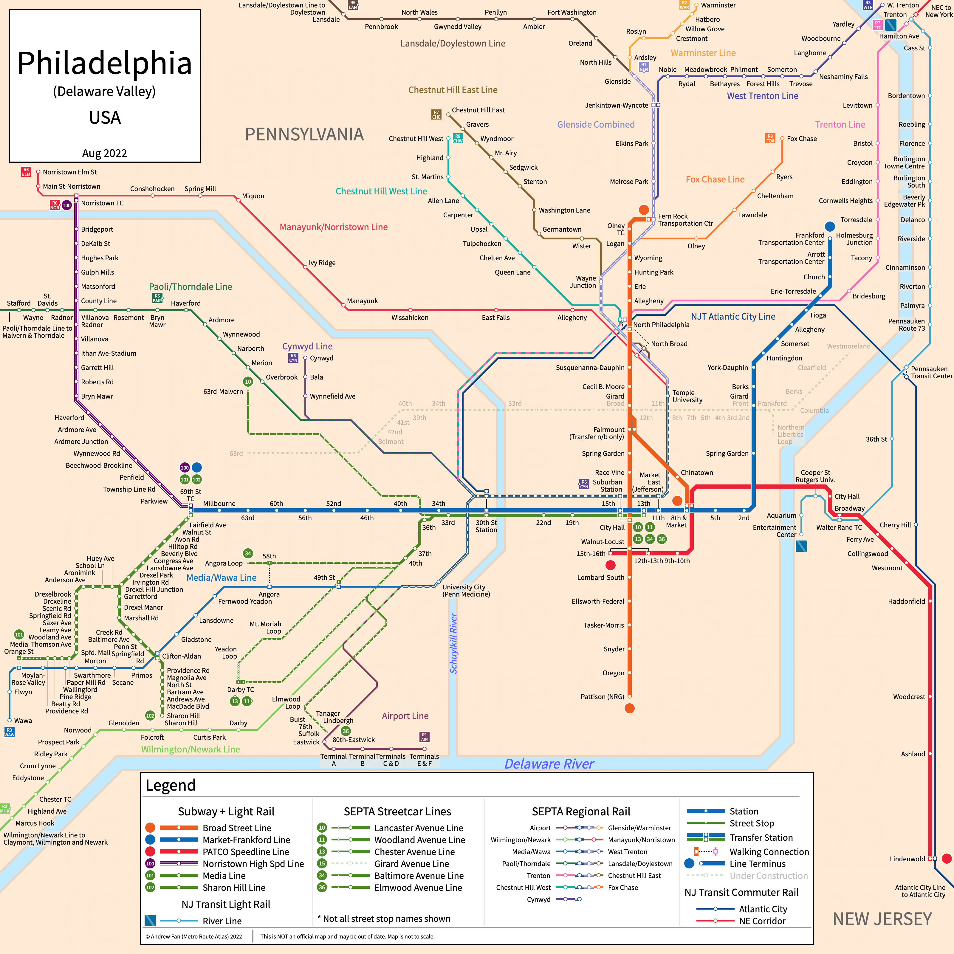
Table of Contents
Overview - Philadelphia
Located on the Delaware River, Philadelphia is the largest city by population in Pennsylvania. It has approximately 1,551,000 inhabitants in the city proper as of 2023. The Philadelphia metropolitan area (Philadelphia-Camden-Wilmington) comprised 6,246,160 residents as of the 2023 US Census Bureau Estimate.
Philadelphia's rapid transit network consists of three metro services, one light metro service, two light rail services, and subway-surface streetcars with five branches. It also has a standard streetcar service, 14 commuter rail lines and services, 13 of which converge in a city center tunnel, and a regional rail line that runs exclusively on the New Jersey side.
SEPTA City Transit Division
SEPTA's City Transit Division contains two rapid transit services, five subway-surface streetcar services, and a standard streetcar service that serve the city of Philadelphia, Pennsylvania.
B - Broad Street Line
The Broad Street Line is a metro service on a North-South alignment. Running primarily under Broad Street, it runs from Fern Rock Transit Center in the north to Pattison (NRG) station in the south, with a spur (Broad Ridge Spur) to 8th-Market. It serves 25 stations.
The Broad Street Line was opened in September 1928 and the last extension to the line was in March 1991 when express tracks were completed from Erie to Olney. The Broad Street Line is owned by the City of Philadelphia and operated by SEPTA.
| Service | M-F Midday | M-F Rush | Sat. | Sun. | Notes |
|---|---|---|---|---|---|
| B1 - Broad Street Local | 8' | 8' | 10' | 10' | |
| B2 - Broad Street Express | No Service | 7' | No Service | No Service | |
| B3 - Broad Ridge Spur | 15' | 7' | 20' | No Service |
Schedules -- Last Updated: Apr 3, 2025
L - Market-Frankford Line
The Market-Frankford Line is a metro service on a Northeast-West alignment. Running primarily on Market Street and Frankford Avenue, it runs from 69th Street Transit Center in the west to Frankford Transit Center station in the northeast, serving 28 stations.
The Market-Frankford Line was opened in March 1907 (only parts of Market Street portion) and the last extension to the line was in 2003 when the Frankford Transportation Center was built, replacing the old terminal. The Market-Frankford Line is owned by the City of Philadelphia and SEPTA and operated by SEPTA.
| Service | M-F Midday | M-F Rush | Sat. | Sun. | Notes |
|---|---|---|---|---|---|
| L - Market-Frankford Line | 6' | 6' | 10' | 10' |
Schedules -- Last Updated: Apr 3, 2025
T - Subway-Surface Lines
The Subway-Surface Lines (10, 11, 13, 34, 36) are a subway-surface streetcar and light rail network on an East-West alignment. All services use a tunnel under Market Street adjacent to the Market-Frankford Line from 33rd Street in the west to 13th Street in the east, with all lines other than Line 10 also stopping at 36th and 37th street stations in the tunnel. In the west, Line 10 continues to Overbrook via Lancaster Ave. Line 11 continues to Darby via Woodland Ave. Line 13 continues to Darby via Chester Ave. Line 34 continues to Angora via Baltimore Ave. Line 36 continues to Eastwick via Elmwood Ave.
The Subway-Surface lines are owned and operated by SEPTA.
| Service | M-F Midday | M-F Rush | Sat. | Sun. | Notes |
|---|---|---|---|---|---|
| T1 - 10 | 10' | 10' | 15-20' | 20' | |
| T2 - 34 | 10' | 10' | 15-20' | 20' | |
| T3 - 13 | 10' | 10' | 15-20' | 20' | *1 |
| T4 - 11 | 10' | 10' | 15-20' | 20' | |
| T5 - 36 | 10' | 10' | 15' | 20' |
Schedules -- Last Updated: Apr 3, 2025
*1 - See timetables for service past Yeadon Loop
G - Girard Avenue Line (15)
The Girard Avenue Line is a streetcar service on an East-West alignment running primarily along Girard Avenue from 63rd-Girard in the west to Richmond-Westmoreland in the east. We are currently unsure how service to the Frankford-Delaware loop operates.
The Girard Avenue Line was opened in 1859 and was reopened in 2005 after being closed in 1992. The entire line was closed again between January 2020 and June 2024. The Girard Avenue Line is operated by SEPTA.
| Service | M-F Midday | M-F Rush | Sat. | Sun. | Notes |
|---|---|---|---|---|---|
| G - 15 | 10' | 10' | 15' | 15' | *1 |
Schedules -- Last Updated: Apr 3, 2025
*1 - See timetables for which journeys make the detour into the Frankford-Delaware loop during rush hours
SEPTA Suburban Division
SEPTA's Suburban Division contains two interurban light rail services that serve the western suburbs of Philadelphia, Pennsylvania, as well as a completely grade separated light metro service.
M - Norristown High Speed Line
The Norristown High Speed Line is a light metro service on a North-South alignment. It runs from Norristown Transit Center in the north to 69th Street Transit Center in the south, serving 22 stations.
The Norristown High Speed Line was opened in 1907. The Norristown High Speed Line is operated by SEPTA.
| Service | M-F Midday | M-F Rush | Sat. | Sun. | Notes |
|---|---|---|---|---|---|
| M1 - Norristown HSL | 30' | 15' | 20' | 20-30' |
Schedules -- Last Updated: Apr 3, 2025
D - Media-Sharon Hill Line (101, 102)
The former Red Arrow Media (101) and Sharon Hill (102) Lines are a light rail network on an East-Southwest alignment running from the 69th Street Transit Center in the east to Media and Sharon Hill in the west.
The Sharon Hill Line was opened in 1906 and the Media Line was opened in 1913. The Media and Sharon Hills Lines are operated by SEPTA.
| Service | M-F Midday | M-F Rush | Sat. | Sun. | Notes |
|---|---|---|---|---|---|
| D1 - 101 | 30' | 20' | 30' | 30' | |
| D2 - 102 | 30' | 20' | 30' | 30' |
Schedules -- Last Updated: Apr 3, 2025
PATCO
The Port Authority Transit Corporation operates a single rapid transit line between Philadelphia and its New Jersey suburbs.
PATCO Speedline
The PATCO Speedline is a metro service on an East-West alignment. It runs from Lindenwold in the east to 15/16th & Locust St. in Downtown Philadelphia in the west via Camden, New Jersey, serving 14 stations.
The PATCO Speedline was opened in 1969. The latest expansion was the reopening of Franklin Square in April 2025. The PATCO Speedline is owned by the Delaware River Port Authority and is operated by PATCO.
| Service | M-F Midday | M-F Rush | Sat. | Sun. | Notes |
|---|---|---|---|---|---|
| PATCO | 15' | 6-8' | 20' | 30' |
Schedules -- Last Updated: Apr 03, 2025
New Jersey Transit
Within the Philadelphia area, New Jersey Transit operates a commuter rail service and a diesel light rail service.
River Line
The River Line is a regional rail service on a northeast-southwest alignment primarily paralleling the Delaware River. It runs from Trenton in the northeast to Camden's Entertainment Center in the southwest, serving 21 stations.
The River Line was opened in March 2004. The River Line is owned by New Jersey Transit.
| Service | M-F Midday | M-F Rush | Sat. | Sun. | Notes |
|---|---|---|---|---|---|
| River LINE | 30' | 15' | 30' | 30' |
Schedules -- Last Updated: Apr 3, 2025
Atlantic City Line
The Atlantic City Line is a commuter rail service on an east-west alignment. It runs from Atlantic City in the east to Philadelphia 30th Street Station in the west along the White Horse Pike corridor, serving 9 stations.
The Atlantic City Line was reopened in May 1989. The latest expansion to service was the opening of the Pennsauken Transit Center in October 2013. The Atlantic City Line is operated by New Jersey Transit.
SEPTA Regional Rail
SEPTA's Regional Rail network consists of 13 commuter rail lines running through a city center tunnel called the City Center Commuter Connection (CCCC), which serves all lines except for the Cynwyd Line, which terminates at Suburban Station. All strip maps below treat the section from 30th Street Station to Temple University as the CCCC and use that icon for transfers in order to simplify the map. The section between the CCCC and Glenside station (Glenside Combined) is listed here under the Warminster Line. All station counts include the CCCC. All SEPTA Regional Rail services are operated by SEPTA Regional Rail. As through service patterns change with each timetable revision, as of April 2025 we are no longer showing detailed through service patterns on strip maps.
Airport Line
The Airport Line is a commuter rail line on a northeast-southwest alignment. It runs from all airport terminals in the southwest to Temple University on the CCCC in the northeast, serving 10 stations and with through service to Norristown (weekends), and Warminster.
The Airport Line was opened in April 1985.
| Service | M-F Midday | M-F Rush | Sat. | Sun. | Notes |
|---|---|---|---|---|---|
| Airport | 30' | 30' | 60' | 60' |
Schedules -- Last Updated: Apr 3, 2025
Chestnut Hill East Line
The Chestnut Hill East Line is a commuter rail line on a north-south alignment. It runs from Chestnut Hill East in the north to 30th Street Station on the CCCC in the south, serving 14 stations and with through service to Trenton.
Chestnut Hill West Line
The Chestnut Hill West Line is a commuter rail line on a north-south alignment. It runs from Chestnut Hill West in the north to Temple University on the CCCC in the south, serving 14 stations and with through service to Fox Chase (weekdays) and West Trenton (weekends).
Cynwyd Line
The Cynwyd Line is a commuter rail line on a northwest-southeast alignment. It runs from Cynwyd in the northwest to Suburban Station on the CCCC in the southeast, serving 5 stations.
The Cynwyd Line was cut back to Cynwyd from Ivy Ridge in May 1986.
Fox Chase Line
The Fox Chase Line is a commuter rail line on a northeast-southwest alignment. It runs from Fox Chase in the northeast to 30th Street Station on the CCCC in the southwest, serving 10 stations and with through service to the Chestnut Hill West (weekdays) and Malvern and Thorndale (weekends).
Lansdale/Doylestown Line
The Lansdale/Doylestown Line is a commuter rail line on a north-south alignment. It runs from Lansdale and Doylestown in the north to 30th Street Station on the CCCC in the south, serving 28 stations and with through service to Marcus Hook and Wilmington (weekdays) and Wawa (weekends). Only service to Lansdale is shown on the strip map above. Elkins and Melrose Park are not shown on the strip map above since nearly all Lansdale/Doylestown services bypass those stations as of the October 2019 timetable.
Manayunk/Norristown Line
The Manayunk/Norristown Line is a commuter rail line on a northwest-south alignment. It runs from Norristown in the northwest to 30th Street Station on the CCCC in the south, serving 16 stations and with through service to Wawa (weekday) or the Airport (weekend).
Media/Wawa Line
The Media/Wawa Line is a commuter rail line on an east-west alignment. It runs from Wawa in the west to Temple University on the CCCC in the south, serving 20 stations and with through service to Norristown (weekdays) and Doylestown (weekends).
The last extension of the line was the restoration of service to Wawa in August 2022.
Paoli/Thorndale Line
The Paoli/Thorndale Line is a commuter rail line on an east-west alignment. It runs from Thorndale and Malvern in the west to Temple University on the CCCC in the south, serving 26 stations and with through service to West Trenton (weekdays) and Fox Chase (weekends). Only service to Malvern is shown on the strip map above.
Trenton Line
The Trenton Line is a commuter rail line on an east-west alignment serving local stations on the Northeast Corridor. It runs from Trenton in the east to Temple University on the CCCC in the west, serving 15 stations and with through service to Chestnut Hill East.
Warminster Line
The Warminster Line is a commuter rail line on a north-south alignment. It runs from Warminster in the north to 30th Street Station on the CCCC in the south via Glenside, serving 17 stations and with through service to the Airport.
West Trenton Line
The West Trenton Line is a commuter rail line on a northeast-south alignment. It runs from West Trenton in the northeast to 30th Street Station on the CCCC in the south, serving 22 stations and with through service to Newark/Wilmington and Malvern/Thorndale (weekdays) and Chestnut Hill West (weekdays).
Wilmington/Newark Line
The Wilmington/Newark Line is a commuter rail line on a northeast-southwest alignment. It runs from Newark, Wilmington, and Marcus Hook in the southwest to Temple University on the CCCC in the northeast, serving 22 stations. Some trains continue to Doylestown (weekdays) and Chestnut Hill East (weekends).
References & Helpful Links
SEPTA Regional Rail at Wikipedia
Atlantic City Line at Wikipedia
Official Website for SEPTA: Southeastern Pennsylvania Transportation Authority
Official Website for PATCO: Port Authority Transit Corporation
Official Website for River Line: New Jersey Transit
Official Website for New Jersey Transit Commuter Rail: New Jersey Transit
Maps
All Official Maps - Southeastern Pennsylvania Transportation Authority [Last Accessed April 03, 2025]
All Official Maps - Port Authority Transit Corporation [Last Accessed April 03, 2025]
Official System Map - SEPTA Regional Rail [PDF] [Last Accessed April 03, 2025]
Official System Map - SEPTA [PDF] [Last Accessed April 03, 2025]
Official Line Map - River Line [PDF] [Last Accessed December 08, 2025]
Official System Map - New Jersey Transit Commuter Rail [PDF] [Last Accessed December 08, 2025]
Unofficial Map - SEPTA Regional Rail and Rapid Transit [April 2016] by Sam Winfield (www.transitmap.net) - Full
Other Sources
Philadelphia, USA at Urbanrail.net
Asset Notes
SEPTA and PATCO route colors originally taken from official SEPTA map as of October 2019. SEPTA Metro colors adopted April 2025 for SEPTA lines (excluding regional rail) only.
SEPTA Regional Rail colors taken from route timetables as of October 2019. SEPTA text color taken from Regional Rail color on SEPTA map as of October 2019.
River Line line colors taken from October 2019 official River Line map.
New Jersey Transit rail line colors taken from June 2019 official NJT Rail map. New Jersey Transit text color taken from official NJ Transit logo.