Chicago, Illinois, USA
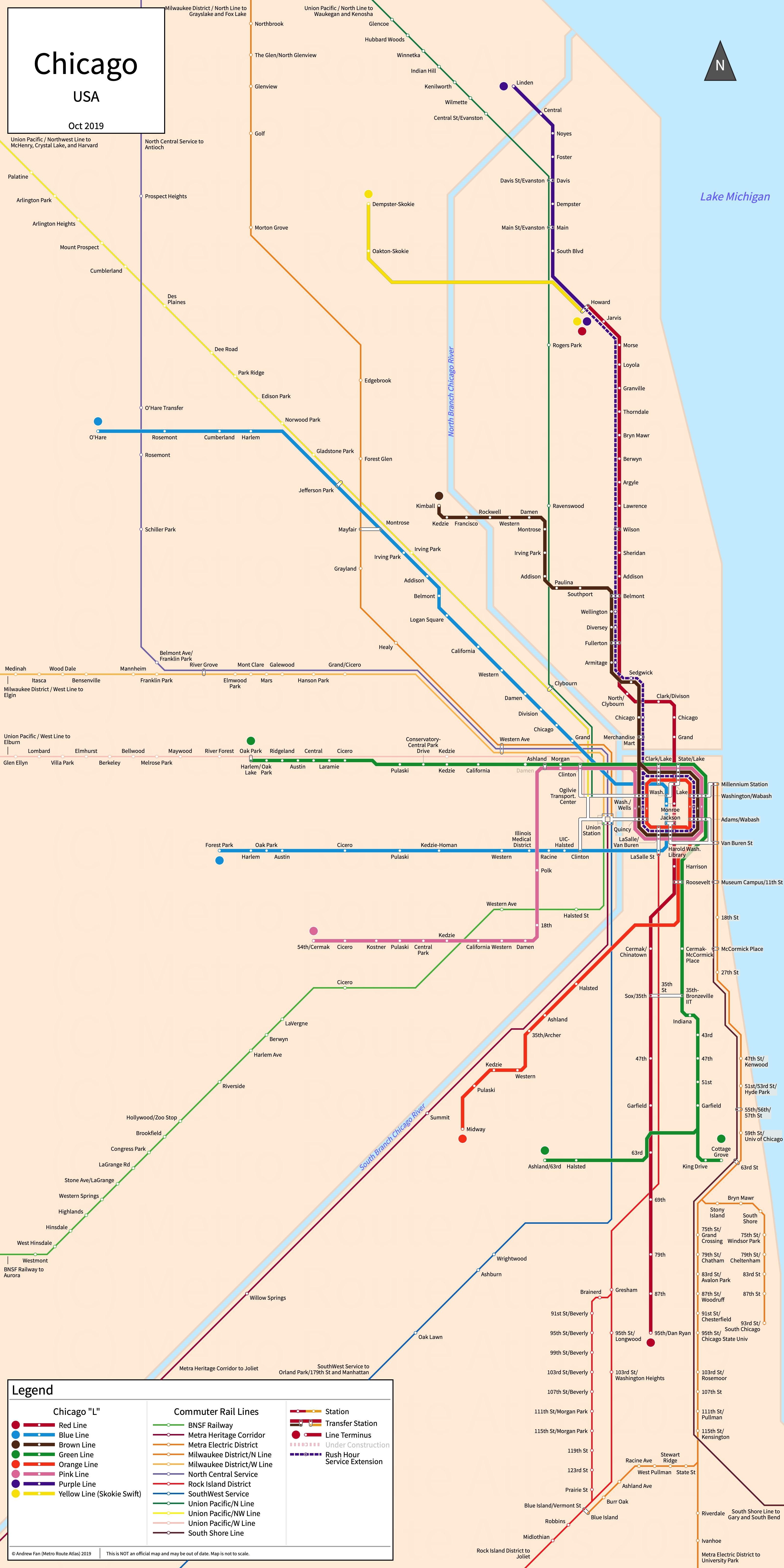
Table of Contents
Overview - Chicago

Located on the western shore of Lake Michigan, Chicago is the largest city by population in Illinois and is the third largest city by population in the United States of America. It has approximately 2,664,000 inhabitants in the city proper as of 2023. The Chicago metropolitan area (Chicago-Naperville-Elgin) comprised 9,262,825 residents as of the 2023 US Census Bureau Estimate.
Chicago's rapid transit network consists of eight metro services. It also has twelve commuter rail services. It also has arterial bus rapid transit services, which are not covered on this website.
Chicago L
Opened 1892, the Chicago "L" consists of eight metro services that serve the city of Chicago, Illinois and the surrounding suburbs. Two of the lines run underground in the downtown area, two primarily run in the northern suburbs, and many lines merge in the downtown loop.
Red Line
The Red Line of the Chicago "L" is a metro service on a North-South alignment, running from Howard in the north to 95th/Dan Ryan in the south via Downtown Chicago and serving 33 stations. In the north, it runs elevated and serves local stations on the North Side Main Line, then runs underground downtown in the State Street Subway before running in the median of the Dan Ryan Expressway in the south.
The Red Line began operation in its current form in February 1993 though some of its trackage dates back to 1990. The Red Line is owned and operated by the CTA.
| Service | M-F Midday | M-F Rush | Sat. | Sun. | Notes |
|---|---|---|---|---|---|
| Red | 7-8' | 4-6' | 6' | 7-8' |
Schedules -- Last Updated: Mar 4, 2025
Blue Line
The Blue Line of the Chicago "L" is a metro service on a West-Northwest alignment, running from O'Hare in the northwest to Forest Park in the west via Downtown Chicago and serving 33 stations. In the northwest, it runs primarily in highway medians, then runs underground downtown in the Milwaukee-Dearborn Subway before running in the median of the Eisenhower Expressway in the west.
The Blue Line began operation in its current form in February 1993 though some of its trackage dates back to 1895. The Blue Line is owned and operated by the CTA.
| Service | M-F Midday | M-F Rush | Sat. | Sun. | Notes |
|---|---|---|---|---|---|
| Blue | 6/12' | 3-8/7-8' | 6/12' | 6/12' | *1 |
Schedules -- Last Updated: Mar 4, 2025
*1 - Approximately every other train terminates at UIC/Halsted
Brown Line
The Brown Line of the Chicago "L" is a metro service on a Northwest-South alignment, running from Kimball in the northwest to The Loop in Downtown Chicago and serving 27 stations. It runs partially at-grade on the Ravenswood Branch and then runs on the North Side Main Line south to the loop.
The Brown Line began operation in its current form in August 1949. The Brown Line is owned and operated by the CTA.
| Service | M-F Midday | M-F Rush | Sat. | Sun. | Notes |
|---|---|---|---|---|---|
| Brown | 7-8' | 4-8' | 8-9' | 10' |
Schedules -- Last Updated: Mar 4, 2025
Green Line
The Green Line of the Chicago "L" is a metro service on a West-South alignment, running from Harlem in the west to Ashland/63rd and Cottage Grove in the south via the Loop in Downtown Chicago and serving 31 stations. It runs above Lake Street in the west and the Loop in downtown, and runs on the South Side Main Line before branching to its two terminals.
The Green Line began operation in its current form in February 1993 though some of its trackage dates back to 1892. The last expansion to the line was the reopening of Damen in August 2024. The Green Line is owned and operated by the CTA.
| Service | M-F Midday | M-F Rush | Sat. | Sun. | Notes |
|---|---|---|---|---|---|
| Green | 10' | 8-9' | 10' | 10' | *1 |
Schedules -- Last Updated: Mar 4, 2025
*1 - Combined service shown. Trains alternate between Ashland/63rd and Cottage Grove.
Orange Line
The Orange Line of the Chicago "L" is a metro service on a North-Southwest alignment, running from Midway in the southwest to the Loop in Downtown Chicago and serving 16 stations.
The Orange Line began operation in October 1993. The Orange Line is owned and operated by the CTA.
| Service | M-F Midday | M-F Rush | Sat. | Sun. | Notes |
|---|---|---|---|---|---|
| Orange | 8-9' | 7-8' | 10' | 10' |
Schedules -- Last Updated: Mar 4, 2025
Purple Line
The Purple Line of the Chicago "L" is a metro service on a North-South alignment, running from Linden in the north to Howard in the south and serving 9 stations, though it continues to the Loop during weekday rush hours as an express service and serves 26 stations on a alignment primarily on the Evanston Line and North Side Main Line together with the Red and Brown lines.
The Purple Line began operation in July 1949. The Purple Line is owned and operated by the CTA.
| Service | M-F Midday | M-F Rush | Sat. | Sun. | Notes |
|---|---|---|---|---|---|
| Purple | 7-11' | 7-8' | 12' | 12' |
Schedules -- Last Updated: Mar 4, 2025
Pink Line
The Pink Line of the Chicago "L" is a metro service on an East-West alignment, running from 54th/Cermak in the north to the Loop in Downtown Chicago and serving 22 stations. It runs on the Douglas Branch, formerly part of the Blue Line.
The Pink Line began operation in June 2006 and was formally split from the Blue Line in December 2008. The Pink Line is owned and operated by the CTA.
| Service | M-F Midday | M-F Rush | Sat. | Sun. | Notes |
|---|---|---|---|---|---|
| Pink | 10' | 8-9' | 10' | 10' |
Schedules -- Last Updated: Mar 4, 2025
Yellow Line
The Yellow Line of the Chicago "L", commonly referred to as the Skokie Swift, is a metro service on an East-West alignment, running from Dempster-Skokie in the west to Howard in the east and serving 3 stations.
The Yellow Line was reopened in April 1964. The latest expansion to the line was the opening of Oakton-Skokie in June 2010. The Yellow Line is owned and operated by the CTA.
| Service | M-F Midday | M-F Rush | Sat. | Sun. | Notes |
|---|---|---|---|---|---|
| Yellow | 15' | 12' | 15' | 15' |
Schedules -- Last Updated: Mar 4, 2025
Metra
Begun operation in 1984, Metra consists of 11 commuter rail services running from downtown Chicago terminal stations out to the suburbs, reaching as far as Wisconsin and Indiana.
BNSF Railway
The BNSF Railway of the Metra commuter railway network is a commuter rail service on an East-West alignment, running from Chicago Union Station in the east to Aurora in the west and serving 26 stations.
The BNSF Railway has operated in some form since 1864 and is Chicago's oldest commuter rail line. The BNSF Railway is owned by BNSF and operated by BNSF and Metra.
Heritage Corridor
The Heritage Corridor of the Metra commuter railway network is a commuter rail service on a Northeast-Southwest alignment, running from Chicago Union Station in the northeast to Joliet in the southwest and serving 7 stations. The Heritage Corridor only operates weekdays in the peak direction.
The Heritage Corridor was last expanded with the opening of Romeoville station in February 2018. The Heritage Corridor is owned by Canadian National and is operated by Canadian National and Metra.
Metra Electric District
The Electric District of the Metra commuter railway network is a commuter rail service on a North-South alignment, running from Chicago Millennium Station in the north to University Park in the south with two southern branches to South Chicago and Blue Island, serving 49 stations in total. Trackage is shared with the South Shore Line from Millennium Station to 111 St.
The Electric District was opened in July 1856, with the South Chicago branch opening in the 1880s and the Blue Island branch opening in the 1890s. The last extension was to University Park in 1977. The Electric District is owned and operated by Metra.
Milwaukee District/North Line
The Milwaukee District/North Line of the Metra commuter railway network is a commuter rail service on a North-South alignment, running from Chicago Union Station in the south to Fox Lake in the north, serving 22 stations. Some trains only go as far as Deerfield or Grayslake. Only service to Grayslake is shown on the above strip map.
The Milwaukee District/North Line is owned by Metra and operated by Canadian Pacific, Metra, and the Wisconsin & Southern Railroad.
Milwaukee District/West Line
The Milwaukee District/West Line of the Metra commuter railway network is a commuter rail service on an East-West alignment, running from Chicago Union Station in the east to Elgin and Big Timber Road in the west, serving 22 stations. Big Timber Road is not served on weekends as of September 2019. It runs alongside the North Central Service from Union Station to River Grove, serving local stations.
The Milwaukee District/West Line is owned by Metra and operated by Canadian Pacific and Metra.
North Central Service
The North Central Service of the Metra commuter railway network is a commuter rail service on a North-South alignment, running from Chicago Union Station in the south to Antioch in the north, serving 18 stations. There is no service on weekends as of September 2019. It runs alongside the Milwaukee District/West Line from Union Station to River Grove but does not serve local stations on this section.
The North Central Service began operation in August 1996 and the last extension was the opening of the Franklin Park, Schiller Park, Rosemont, and Grayslake stations in January 2006. The North Central Service is owned by Metra and Canadian Pacific and is operated by Metra.
Rock Island District
The Rock Island District of the Metra commuter railway network is a commuter rail service on a North-Southwest alignment, running from Chicago LaSalle Street Station in the north to Blue Island-Vermont Street and Joliet in the southwest, serving 26 stations with two branches in the middle.
The Rock Island District began operation in its current form in 1980 and the latest expansion to the line was the opening of 35th St Station in April 2011. The Rock Island District is owned by Metra and CSX and is operated by Metra, CSX, Iowa Interstate Railroad, and Chicago Rail Link.
SouthWest Service
The SouthWest Service of the Metra commuter railway network is a commuter rail service on a North-Southwest alignment, running from Chicago Union Station in the north to Orland Park 179th St and Manhattan in the southwest, serving 13 stations. Laraway Road and Manhattan are only served during peak hours.
The SouthWest Service had operation transferred from Norfolk Southern to Metra in June 1993, and the latest extension was the opening of Laraway Road in October 2006. The SouthWest Service is owned by Norfolk Southern and is operated by Metra and Norfolk Southern.
Union Pacific/North Line
The Union Pacific/North Line of the Metra commuter railway network is a commuter rail service on a North-South alignment, running from Chicago Ogilvie Station in the south to Waukegan and Kenosha in the north, serving 28 stations. Only service to Waukegan is shown on the above strip map.
The Union Pacific/North Line began operation in its current form in 1971 with the truncation of the line to Kenosha. The latest expansion was the opening of Peterson/Ridge in May 2024. The Union Pacific/North Line is owned by Union Pacific and is operated by Metra and Union Pacific.
Union Pacific/Northwest Line
The Union Pacific/Northwest Line of the Metra commuter railway network is a commuter rail service on a Northwest-South alignment, running from Chicago Ogilvie Station in the south to Crystal Lake, McHenry, and Harvard in the northwest, serving 23 stations.
The Union Pacific/Northwest Line is owned by Union Pacific and is operated by Metra and Union Pacific.
Union Pacific/West Line
The Union Pacific/West Line of the Metra commuter railway network is a commuter rail service on an East-West alignment, running from Chicago Ogilvie Station in the east to Elburn in the west, serving 19 stations.
The Union Pacific/West Line began operation in its current form in the 1940s with the removal of the Freeport Branch. The Union Pacific/West Line is owned by Union Pacific and is operated by Metra and Union Pacific.
South Shore Line
Begun operation in 1903, the South Shore Line consists of a single commuter rail line running from downtown Chicago along Lake Michigan's south shore into Indiana.
South Shore Line
The South Shore Line is a commuter rail service on an East-Northwest alignment, running from Chicago Millennium Station in the northwest to Munster/Dyer, Gary, Michigan City, and South Bend Airport in the east and serving 21 stations.
The South Shore Line has operated in some form since 1901. The last expansion was the opening of the Monon Corridor to Munster/Dyer in April 2026. The South Shore Line is operated by the Northern Indiana Commuter Transportation District.
References & Helpful Links
Official Website for Chicago "L": CTA
Official Website for Metra: Metra
Official Website for South Shore Line: NICTD
Maps
All Official Maps - CTA [Last Accessed April 01, 2026]
Official System Map - Chicago "L" [PDF] [Last Accessed April 01, 2026]
Official System Map - CTA and Metra [PDF] [Last Accessed April 01, 2026]
Unofficial Map - Chicago "L" [July 2019] by Jug Cerovic (www.inat.fr)
Unofficial Map - Chicago Urban Rail [Feb 2016] by Kara Fischer (transitmap.net)
Unofficial Map - Metra Commuter Rail [June 2018] by Rahul Raju (transitmap.net)
Unofficial Map - Chicagoland Rail Map [2025] by BukaBuka243 (drive.google.com)
Other Sources
Asset Notes
Chicago L colors taken from CTA branding guide as of September 26, 2019
Metra color taken from official Metra Logo as of September 26, 2019
South Shore Line color taken from banner at top of website as of September 26, 2019
Metra and South Shore Line colors taken from CTA's Metra map as of September 26, 2019
O'Hare ATS color taken from official website as of June 7, 2024