Baltimore, Maryland, USA
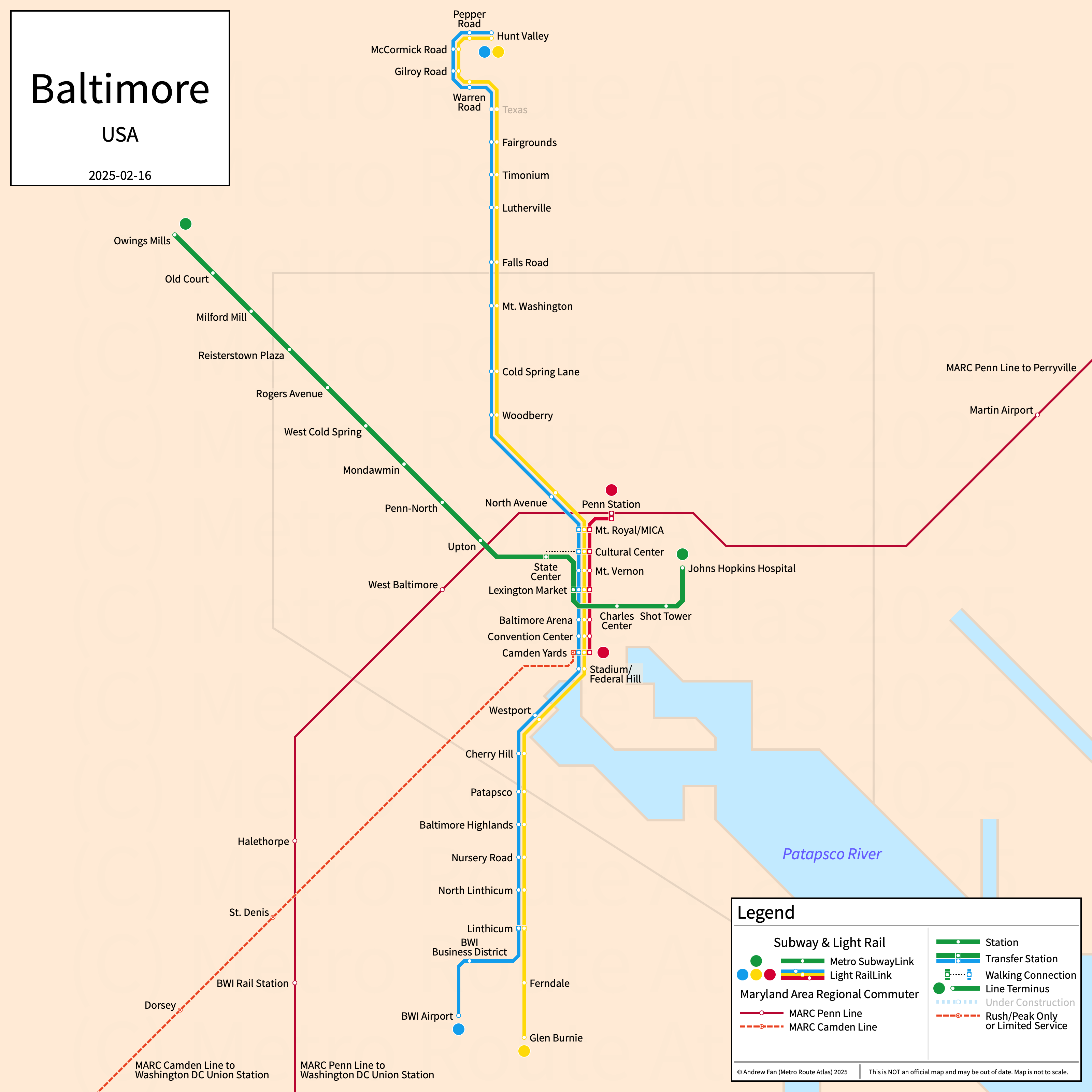
Table of Contents
Overview - Baltimore
Located at the mouth of the Patapsco River, Baltimore is an independent city and the largest city in Maryland by population. It has approximately 565,000 inhabitants in the city proper as of 2023. The Baltimore metropolitan area (Baltimore-Columbia-Towson) comprised 2,834,316 residents as of the 2023 US Census Bureau Estimate.
Baltimore's rapid transit network consists of a light rail line with three services and a metro service. Two commuter rail services operate in Baltimore, connecting it to Washington DC.
Baltimore Metro SubwayLink
Opened 1983, the Baltimore Metro Subway consists of a single rapid transit service serving the city of Baltimore, Maryland.
Baltimore Metro Subway
The Metro Subway, branded Metro SubwayLink, is a metro service with a horizontally flipped J-shaped alignment, running from Owings Mills in the northwest to Johns Hopkins Hospital in the east via the city center of Baltimore and serves 14 stations. The line is primarily elevated outside of the downtown core of the city.
The Metro Subway was opened in November 1983 and the last expansion to the line was the opening of the eastern extension to the Johns Hopkins Hospital in May 1995. The Metro Subway is operated by the Maryland Transit Administration.
| Service | M-F Midday | M-F Rush | Sat. | Sun. | Notes |
|---|---|---|---|---|---|
| Metro SubwayLink | 10' | 8' | 15' | 15' |
Schedules -- Last Updated: Mar 31, 2026
Baltimore Light Rail
Baltimore Light Rail
The Baltimore Light Rail, branded Light RailLink, is a light rail line with a north to south alignment, running from Hunt Valley in the north to BWI Airport and Glen Burnie via the city center of Baltimore and serves 33 stations. There are two main branches as well as a spur to Penn Station, served by a shuttle running between Penn Station and Camden Yards. The Baltimore Light Rail primarily runs on its own right of way outside of the downtown area, where it runs at street level along Howard Street.
The Baltimore Light Rail was opened in April 1992 and the last expansion to the line was the opening of the Stadium/Federal Hill station (opened as Hamburg Street) in September 1998. The Baltimore Light Rail is operated by the Maryland Transit Administration.
| Service | M-F Midday | M-F Rush | Sat. | Sun. | Notes |
|---|---|---|---|---|---|
| BWI Branch | 30' | 20' | 30' | 30' | |
| Glen Burnie Branch | 30' | 20' | 30' | 30' | *1 |
| Penn-Camden Shuttle | 30' | 30' | 30' | 30' |
Schedules -- Last Updated: Mar 31, 2026
*1 - No service between Fairgrounds and Hunt Valley during rush hours
Maryland Area Regional Commuter (MARC)
For information on MARC, refer to the MARC section on our Washington DC Page.
References & Helpful Links
Baltimore Metro Subway at Wikipedia
Baltimore Light Rail at Wikipedia
Official Website for Baltimore Metro Subway, Baltimore Light Rail, and MARC: Maryland Transit Administration (MTA)
Maps
All Official Maps - Maryland Transit Administration [Last Accessed Mar 31, 2026]
Official System Map - BaltimoreLink Bus & Rail Connections Map [PDF] [Last Accessed Mar 31, 2026]
Official System Map - MARC Train System Map [PDF] [Last Accessed Mar 31, 2026]
Other Sources
Baltimore, USA at Urbanrail.net
Asset Notes
Baltimore Metro and Light Rail line colors taken from official 2012 Bus and Rail Connections Map.
MARC line colors taken from February 2019 official MARC system map. MARC text color taken from official MARC logo.