Columbia, South Carolina, USA
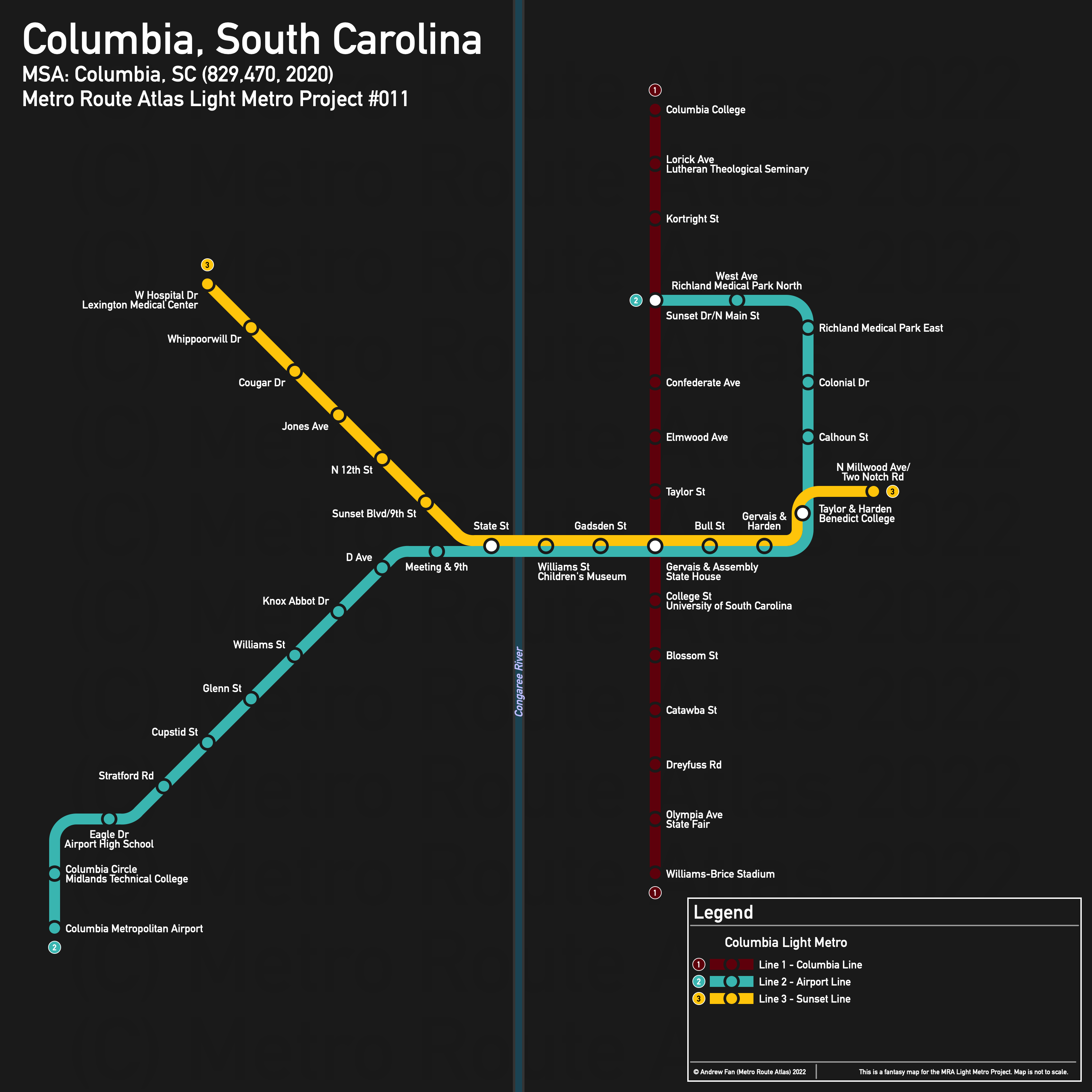
Table of Contents
Overview - Columbia
Located on the Congaree River, Columbia is the capital of and the second largest city by population in South Carolina. It has approximately 136,632 inhabitants in the city proper as of 2020. The Columbia metropolitan area comprised 829,470 residents as of the 2020 US Census.
As of 2019, the main non-government employers in Columbia included Prisma Health, BlueCross BlueShield of South Carolina, and the University of South Carolina. Main universities include the University of South Carolina, Allen University, Benedict College, Columbia College, Columbia International Univeristy, Lutheran Theological Southern Seminary, and Midlands Technical College. The main airport is Columbia Metropolitan Airport. Notable stadiums include Williams-Brice Stadium, Colonial Life Arena, Charlie W. Johnson Stadium (Benedict College), Founders Park, and Segra Park.
Downtown Columbia is enclosed on all sides except the northeast by railways, and has the river directly to the west. Perhaps surprisingly, there are no limited access highways cutting through the downtown core.
The main north-south road corridors are Huger St, Assembly St, Bull St, and Harden St in the city core, and State and 12th Sts west of the river. The main east-west road corridors are I-126/Elmwood Ave, Meeting/Gervais Sts, Knox Abbot Dr/Blossom St. Rail corridors fly out from the city in all directions.
The local public transit agency in Columbia is The COMET, or Central Midlands Regional Transit Authority (CMRTA) (System Map (November 2021)). There are no dedicated transit centers, though a pulse occurs at Comet Central at Sumter and Laurel. Note that as the University of South Carolina has an urban campus, the vast majority of frequent bus service does not exit the city center. 13-20 and 23-25 serve the university.
Below statistics are as of the Winter 2021 timetable:
- Bus routes running every [0, 10] minutes during weekday off-peak: 20
- Bus routes running every (10, 15] minutes during weekday off-peak: 14, 17, 18, 10
- Bus routes running every (15, 30] minutes during weekday off-peak: 1, 4, 13, 15, 101, 301, 401, 501, 701, 801
2020 Census Tract Data suggests that most of the density is on the south side of the city center, with dense pockets in the northeast and northwest. The eastern side of the river tends to be more populous from a density perspective.
Network Design - Thought Process
Columbia has a MSA population of 829,470 and therefore has 166 points to spend (1 point for 1 km regional rail and 5 points for 1 km light metro/new build regional rail).
As the entire city is surrounded by railways, one might think that Columbia would have great potential for a regional rail network. However, of the eight main spokes, most are not very good for frequent rail service. Both southeast corridors serve primarily sports fields and entertainment venues before becoming heavily industrial and quickly entering rural areas. There are no large towns anywhere nearby. The three southwestern corridors tend to have more things along them but are also not very good. The northernmost one, paralleling US-1, is mostly viable, but missing Lexington means that most of the corridor is industrial or serves very low density areas. The middle one that passes south of the airport is a low performer, and the southernmost one serves very little before entering undeveloped areas. There are likewise no major towns on the southwest side.
The northwest and northeastern corridors likewise have issues. The northwestern corridor is on the wrong side of I-126 until St. Andrews Road crosses it, and then primarily serves low density sprawl. The corridor paralleling the river northwards misses the only destination nearby - the Columbia International University. The northern of the northeast corridors serves destinations closer in but then avoids most development, including sprawl. The eastern of the northeast corridors mainly parallels suburban commercial developments, and although it gets points for actually serving things for the entire corridor, it is by far an incredibly inefficient way to serve those destinations unless they're willing to build a heck of a lot of sidewalks and pedestrian bridges.
Due to these profound issues, we will instead opt for a light metro network that aims to serve the core of the city and link together local destinations instead. We will use the Gervais and Assembly corridors to form a north-south line and east-west line.
First, the north-south line. Due to the heavily industrial nature of the south side of the city after exiting the railway loop, we will use the Williams-Brice Stadium as the anchor point, starting on Bluff Rd where the stadium and Gamecock Park cross. Going northwest, the route turns onto Rosewood Drive in order to serve the core of the State Fair. Continuing north, it reaches Assembly St and turns onto it, following it for its entire length. This will allow us to serve the redevelopment at the Old Blowfish Stadium, and be in walking distance of the entire downtown of Columbia. The University of South Carolina, Colonial Life Arena, State House, and COMET Pulse are all within a few minutes of the line. At Elmwood Avenue, the line switches over to Main St, following it to Columbia College Drive. This serves the Lutheran Theological Seminary as well as Columbia College. In total, this is 9.4 km, or 47 points.
Next, our east-west core. From where Sunset Blvd and Meeting St meet, it is 4 km (20 points) east to Harden St and north to Taylor St. This serves Allen University and Benedict College better than using Millwood Avenue and the catchment area contains more of the denser parts of the city. As for where to go on either end, the Lexington Medical Center in the northwest, airport in the southwest, Richland Medical Park in the north, and MUSC Health center to the east are good anchors.
First, for the western branches, we start with Lexington Medical Center. The alignment would run along Sunset Blvd for 5.8 km (29 points), ending at West Hospital Drive with potential for further extension. Next, the airport. There are a number of different options for serving the airport, and the main reason for considering the airport at all is because the Midlands Technical College is right next to it, and there are a number of other key nodes in the area. Starting from the entrance to the airport on Airport Blvd, the proposed alignment heads east, then north along Lexington Dr to the Columbia Circle, where it turns onto Boston Ave. Unfortunately for Platt Springs Rd, it just has less along it than the Edmund Highway/Airport Blvd/Charleston Highway alignment. The proposed alignment uses Boston Avenue, Edmund Highway/Airport Blvd, Charleston Highway, and Meeting St, opting to continue to Meeting St rather than using Knox Abbott Dr since we want to use Meeting St for the main east-west corridor. If the point allowance were higher, a Knox Abbott-Blossom-Devine line to the VA Medical Center would be nice, but alas, decisions need to be made. The length here is 10 km, or 50 points.
As for the eastern branches, the Richland Medical Park alignment uses Harden St to Broad St, then follows Broad north to Academy St, where it turns west and continues to a transfer with the North-South corridor at Main St. This is 3.4 km, or 17 points. To serve the northwest, it would probably be better to branch the north-south corridor to provide one less transfer but extending this would work too. Finally, it's about 0.5 km east along Taylor St from Harden St to Two Notch Rd/Millwood Av. This is 2.5 points. Our total is 165.5 points out of 166.
With this, we have two main corridors forming three light metro services, serving most destinations around the city center, although neglecting the northwest and southeast. Total light metro network length is around 33.1 km.
Columbia Light Metro
The Columbia Light Metro consists of three services of which two are interlined, running in roughly north-south and east-west alignments. Line 1 runs almost entirely on Assembly St and Main St, while Lines 2 and 3 share a common interlined core along Meeting St/Gervais St.
Line 1 - Columbia Line
Line 1 of the Columbia Light Metro is a 9.4 km light metro service on a North-South alignment. It runs from Williams-Brice Stadium in the south to Columbia College in the north via downtown Columbia, serving 14 stations.
The line has an average station spacing of 723m.
The line is named after the city. Originally I considered the corridor name, but Assembly Line has a very negative connotation due to alternate meanings. The color is taken from the Garnet color of the UofSC, taken from their website banner as of September 25, 2022.
Line 2 - Airport Line
Line 2 of the Columbia Light Metro is a 17.4 km light metro service on a southwest-northeast alignment. It runs from Columbia Metropolitan Airport in the southwest to Sunset Dr/N Main St in the north via downtown Columbia, serving 22 stations.
The line has an average station spacing of 829m.
The line is named after its primary destination and one of its main corridors. The color is taken from the airport logo as of September 25, 2022.
Line 3 - Sunset Line
Line 3 of the Columbia Light Metro is a 10.3 km light metro service on an East-West alignment. It runs from W Hospital Drive/Lexington Medical Center in the west to N Millwood Ave/Two Notch Rd in the east via downtown Columbia, serving 14 stations.
The line has an average station spacing of 792m.
The line is named after the road along which it travels in the northwest. The color is taken from the flag of Lexington County as of September 25, 2022.
Realistic Applications
As a constantly growing (albeit slowly) city, Columbia may eventually need higher order public transportation, but given the current conditions, a true rapid transit network of any kind is unlikely in the next few decades. Unfortunately, west of the river, densities are simply too low, and the current network redesign plans that focus more on frequency are not going to bother with frequent service on the west side. If any route has a chance, it is the first line provided here, though likely with the southern bit rerouted along Blossom/Devine (unless the city actively wants to mode shift away from private vehicles for the state fair and Williams-Brice Stadium, both of which tend to see high burst loads).
Overall, a true fantasy map.
References & Helpful Links
External Citations