Boise, Idaho, USA
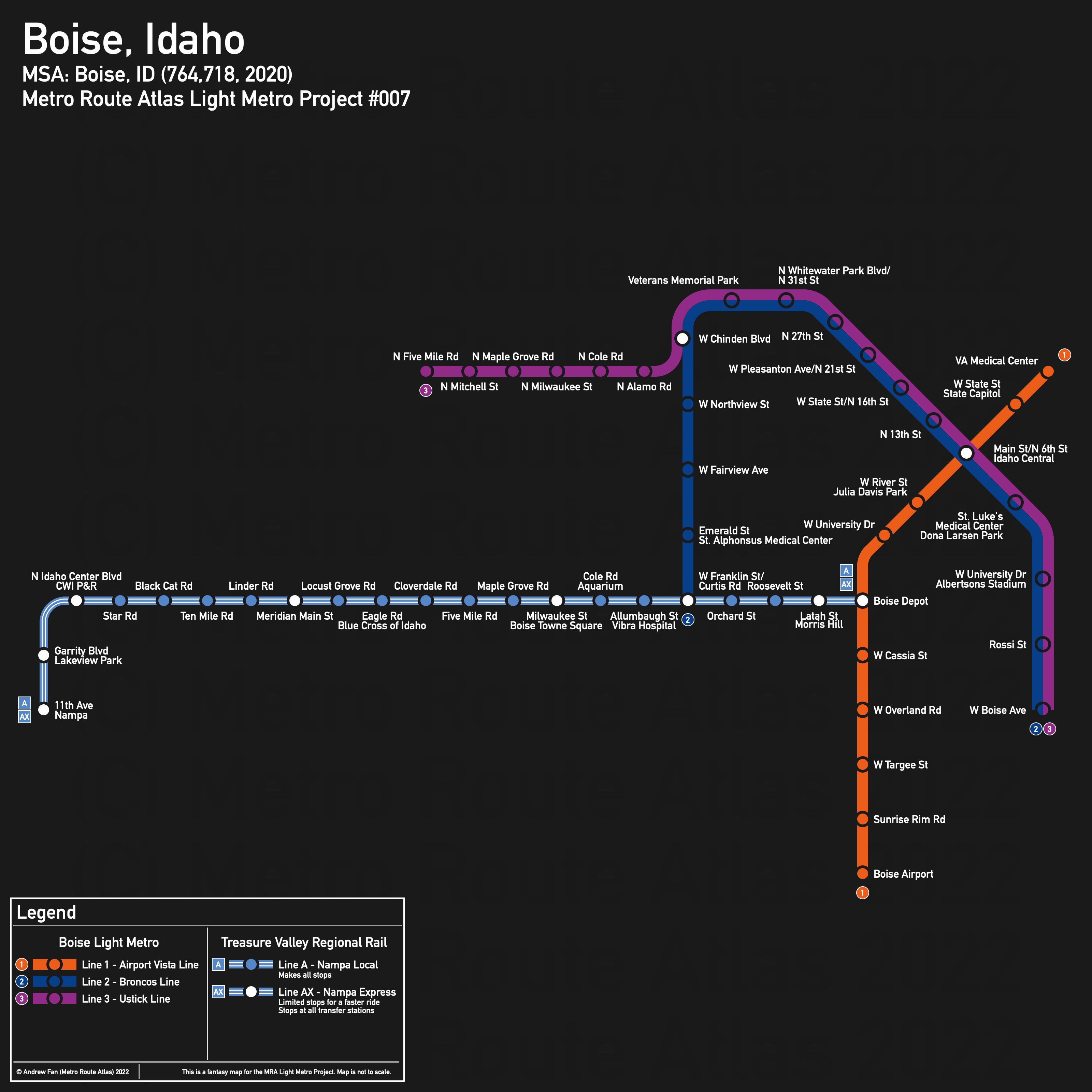
Table of Contents
Overview - Boise
Located on the Boise River, Boise is the capital of and the largest city by population in Idaho. It has approximately 235,684 inhabitants in the city proper as of 2022. The Boise metropolitan area comprised 764,718 residents as of the 2020 US Census.
As of 2020, the main non-government employers in Boise included St. Luke's Health System, Micron Technology, St Alphonsus Health System, Albertsons, Simplot, and HP . Main universities include Boise State University. The main airport is Boise Airport. Notable stadiums include Albertsons Stadium and ExtraMile Arena on the BSU campus as well as Memorial Stadium and Idaho Central Arena.
Boise is notable in that it has only two freeway corridors, and neither touch downtown. The river is the main geographical barrier on the southwest side of downtown, with mountains on the north and east.
In the city center, Main and State Streets are the main northwest-southeast corridors, with N Americana Blvd, Capitol Blvd, and Broadway Ave as the main river crossings. In the western parts of the city, a standard half mile grid forms.
The local public transit agency in Boise is Valley Regional Transit (VRT).
Below statistics are as of the October 2021 timetable:
- Bus routes running every [0, 10] minutes during weekday off-peak:
- Bus routes running every (10, 15] minutes during weekday off-peak:
- Bus routes running every (15, 30] minutes during weekday off-peak: 3, 7 (combined portion), 9
2020 Census Tract Data suggests that most of the density is in the southeast, north of State Street east of 36th St (west of which it becomes more suburban in design), and along the Ustick corridor.
Network Design - Thought Process
Boise has a MSA population of 764,718 and therefore has 153 points to spend (1 point for 1 km regional rail and 5 points for 1 km light metro/new build regional rail).
First, a few notes. There is a rail corridor running from downtown Nampa straight down to Boise State University, just across the river from downtown (and almost in walking distance). This hits the three largest cities of the entire state. Second, there are proposals for higher order transit along State St.
From the old Nampa Train Station to Boise Depot (S Capitol Blvd/S Vista Ave), the rail corridor is 31.5 km long. We will immediately take this, leaving us with 121.5 points left, or 24.3 km of light metro. Note that the rail corridor does continue onwards towards the airport, but reaching the airport would require new build, and the cross streets along this portion of the ROW are very uncooperative, meaning that the station catchment areas are not particularly good.
A core route from here up Capitol Blvd, turning onto Main St to 5th St, and then going up to the VA Medical Center just where the road begins to turn is 3.2 km. This short line alone hits the western part of BSU, the many destinations in Julia Davis Park (Art Museum, Zoo, State Museum, Black History Center...), Boise Center and Idaho Central Arena, City Hall, the State Capitol, and the Medical Center. Taking this leaves us with 21.1 km of light metro.
Next, the State Street corridor. Unfortunately for State Street, Main St is a much better rapid transit corridor in downtown since literally all of downtown is within a 10 minute walk of Main St. Therefore, in downtown, we will have our second light metro corridor along Main St in downtown. On the eastern end, the core of this corridor will start at Main St /E Warm Springs Ave and Ave B/Broadway Ave (Note: We absolutely will be extending this). Going west, we have a few options for reaching State St, but 16th and 23rd make the most sense as 16th allows quick transfers from a Harrison Blvd feeder while 23rd is the only north-south street that doesn't require excessive curves to reach State. 16th St has the better potential for future commercial and residential growth while also upsetting fewer NIMBYs, so we will select this alignment. As for how far to go along State, there is no river crossing between Veterans Memorial Pkwy and N Glenwood St. As catchment area along State St is constrained by the river and has lower density due to suburban development patterns past Veterans Memorial Pkwy, we use this to cross, following Veterans Memorial Pkwy to Ustick Rd. This is 6.9 km, leaving us with 14.2 km.
From here, we can extend in various directions. On the eastern section of our second light metro corridor, it's 1.1 km south to W University Dr, leaving us with 13.1 km. For the south, there are three possibilities - extending our first light metro south along S Vista Ave to the airport (one of the more frequent bus corridors) - 4.1 km, extending regional rail down to the airport - 3.9 km existing + 2.3 km new along I-84 and W Airport Way, or extending our second line down Broadway Ave - 1.2 km to W Boise Ave, 2.4 km to W Linden St, or 3.4 km to S Apple St via Boise Ave. There's also the possibility of a branch down Warm Springs Ave to the penitentiary and botanic garden, but the destinations may not be enough to justify such an expensive infrastructure investment given that this is the edge of the metropolitan area due to geographical constraints.
Meanwhile, on the western side, it is 1.8 km south to W Gage St and St Alphonsus Medical Center, and 2.8 km to connect with the regional line (recommended). It's tempting to serve the Expo grounds and Memorial Stadium but since the area is so spread out and is mainly just empty lots, it's not worth serving unless there's a plan to replace some of those lots with high density housing. Going straight west along Ustick, it's 6.8 km west to Cloverdale Rd, beyond which the density along the corridor sharply drops off.
With 13.1 km left, we will first take the highest value extensions - of these, the 2.8 km regional line and medical center connection is very valuable, leaving us with 10.3 km. Due to the proximity of the airport to downtown and the university, the 4.1 km light metro option is quite good and we will take that as well, leaving us with 6.2 km (the regional rail connection may be faster but it would not go to downtown or the university directly). From here, we will take the 1.2 km extension down Broadway Ave to W Boise Ave - while tempting to go further, continuing south has worse ridership potential than the Ustick corridor and Boise Ave is a fairly narrow road. The remainder of our points will be spent sending the Ustick corridor as far west as we can go - 5 km gets us 200 m from Five Mile Rd, which is good enough.
In the end, our network is respectable, with a reasonable scope and good enough coverage while using or directly paralleling the three busiest bus corridors and covering much of a planned higher order transit corridor.
Boise Light Metro
The Boise Light Metro consists of three services, meeting in downtown Boise as an east-west line and a north-south line. The east-west line has two branches in the west and potential for branches in the east. In downtown, at Idaho Central, the two trunk lines separate into single stacked tracks and have a cross platform interchange, with priority for the south-northwest direction.
Line 1 - Airport Vista Line
Line 1 of the Boise Light Metro is a 7.3 km light metro service on a North-South alignment. It runs from the VA Medical Center in the north to Boise Airport in the south via Idaho Central and Boise Depot, serving 11 stations.
The line has an average station spacing of 730 meters.
The line is named after its destination and main corridor. The color is taken from the VRT logo, using orange as the existing bus route it replaces uses that color.
Line 2 - Broncos Line
Line 2 of the Boise Light Metro is a 12.0 km light metro service on an inverted U shaped alignment. It runs from W Franklin St/Curtis Rd in the west to W Boise Ave in the east via Idaho Central, serving 16 stations.
The line has an average station spacing of 800 meters.
The line is named after the BSU Broncos. The color is taken from the VRT logo, using blue to reflect the team.
Line 3 - Ustick Line
Line 3 of the Boise Light Metro is a 14.2 km light metro service on an East-West alignment. It runs from Five Mile Rd in the west to W Boise Ave in the east via Idaho Central, serving 18 stations.
The line has a station spacing of 835 meters.
The line is named after Ustick Ave, its primary unshared corridor. The color is taken from the VRT logo, using purple because that was what was left after the first two lines got their pick.
Treasure Valley Regional Rail
The Treasure Valley Regional Rail consists of a single line running along the Boise Valley Railroad ROW from Nampa to Boise via Meridian.
Line A - Nampa Line
Line A of the Boise Regional Rail is a 31.5 km regional rail service on a East-West alignment. It runs from Nampa in the west to Boise Depot in the east, serving 21 stations. An express service (marked with AX) leaving immediately prior to each local train skips most of the intermediate stations, allowing for faster rides between the three main cities along the route.
The line has an average station spacing of 1.575 km. Stations are exactly one mile apart on the majority of the line as that is how frequently roads cross the railway.
The line is named after Nampa, one of the cities served and the terminus of the line. The color is from the background of Nampa's flag.
Realistic Applications
Boise is a city that is growing incredibly quickly, and it has the benefit that since almost half the population lives within the Boise metropolitan area (and along a single rail corridor!), the regional rail component should definitely be considered as a future investment, even though it would require double tracking the corridor. Unfortunately it comes short of reaching downtown Boise, but it gets tantalizingly close.
Of the two light metro corridors, the core parts of both have very high potential and would have significant positive benefits. The airport connection would likely be more politically popular, and as a whole the network could provide enough capacity to alleviate or remove the need to expand roads within Boise's core despite population growth.
In the meantime, running frequent bus service on the light metro corridors (which all follow roads) could build the ridership needed to justify such an infrastructure cost. As an alternative, using the regional ROWs (both to Nampa and to the airport) and tram-training them down Capitol Blvd with a loop around the state capital might also be feasible (and fairly cheap).
References & Helpful Links
External Citations