Pittsburgh, Pennsylvania, USA
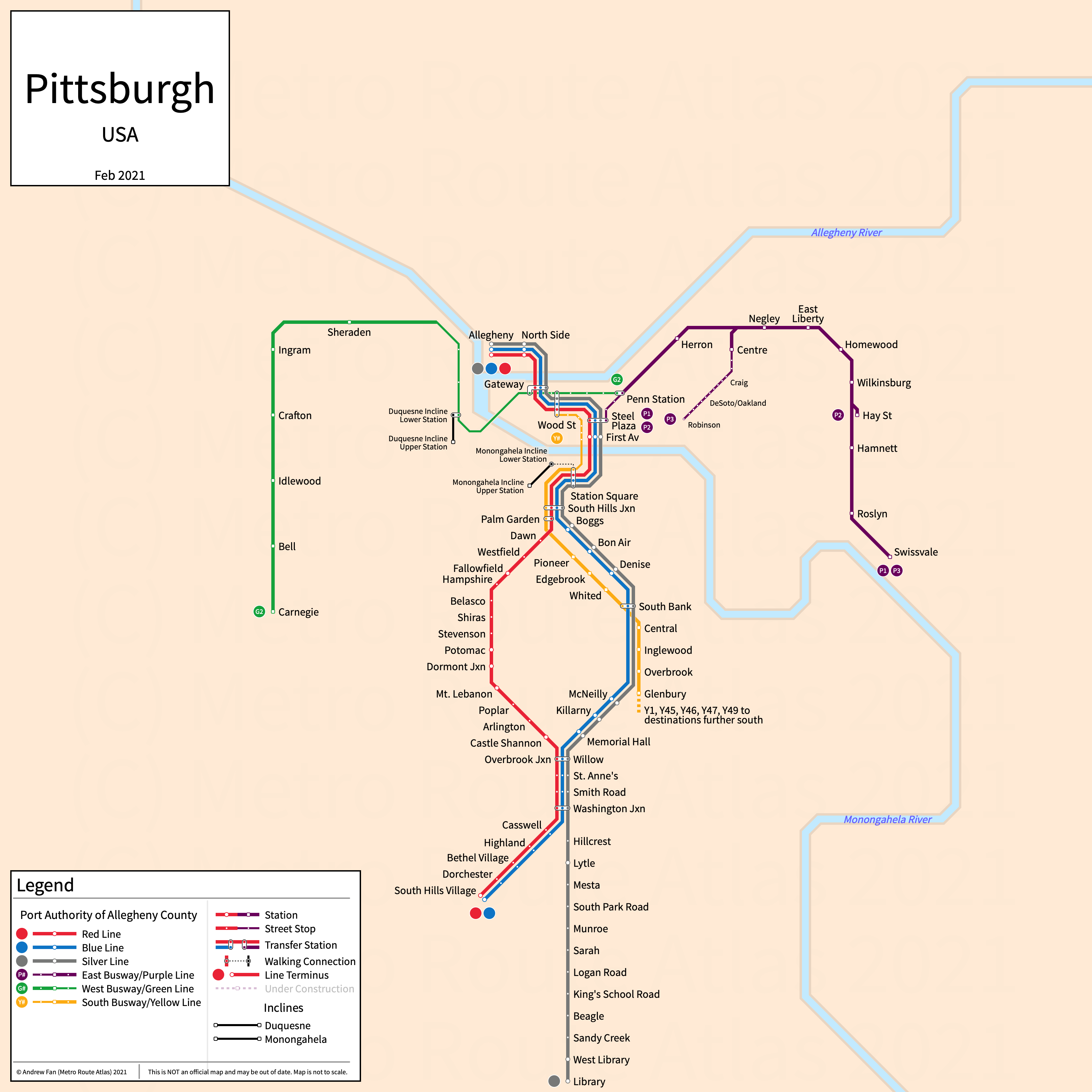
Table of Contents
Overview - Pittsburgh
Located at the confluence of the Monongahela and Allegheny Rivers, Pittsburgh is the seat of Allegheny County and the second largest city by population in Pennsylvania. It has approximately 303,000 inhabitants in the city proper as of 2023. The Pittsburgh metropolitan area (Pittsburgh) comprised 2,422,725 residents as of the 2023 US Census Bureau Estimate.
Pittsburgh's rapid transit network consists of three light rail services and three bus rapid transit open busways of which two have primary services. It also has a rapid bus open busway and retains two funiculars.
The T Light Rail
Opened 1984 as a modern light rail system, The T consists of three light rail services that serve the city of Pittsburgh, Pennsylvania and the southern suburbs. The T is one of the few surviving first-generation streetcar systems in the USA. Services run underground in Downtown Pittsburgh. There is a spur to Penn Station as well as a street-running line (Brown Line, service terminated 2011) that are no longer used in standard service. Starting on February 25, 2025 and running for approximately 8 months afterwards, the Mt. Washington Tunnel is closed, resulting in all trains routing via the Allentown Line and serving a temporary stop at Allen St. Station Square is served by a dedicated shuttle every 35 minutes. These changes are not being shown on our system map or strip maps as they are temporary.
Red Line
The Red Line of the Pittsburgh Light Rail is a light rail service on a North-South alignment, running from Allegheny station in the north to South Hills Village in the south via Downtown Pittsburgh, serving 31 stations.
The Red Line was opened as part of the new Pittsburgh Light Rail in 1984 and the most recent extension was to Allegheny station in 2012. The Red Line is owned and operated by Pittsburgh Regional Transit (f.k.a. the Port Authority of Allegheny County).
| Service | M-F Midday | M-F Rush | Sat. | Sun. | Notes |
|---|---|---|---|---|---|
| Red | 20' | 14' | 20' | 20' |
Schedules -- Last Updated: Aug 27, 2025
Blue Line
The Blue Line of the Pittsburgh Light Rail is a light rail service on a North-South alignment, running from Allegheny station in the north to South Hills Village in the south via Downtown Pittsburgh, serving 24 stations.
The Blue Line was opened as part of the new Pittsburgh Light Rail in 1984 and was renovated heavily in the early 2000s, reopening in 2004 as a modern light rail line. The most recent extension was to Allegheny station in 2012. The Library Branch was rebranded as the Silver Line on March 15, 2020. The Blue Line is owned and operated by Pittsburgh Regional Transit (f.k.a. the Port Authority of Allegheny County).
| Service | M-F Midday | M-F Rush | Sat. | Sun. | Notes |
|---|---|---|---|---|---|
| Blue | 20' | 14' | 40' | 40' |
Schedules -- Last Updated: Aug 27, 2025
Silver Line
The Silver Line of the Pittsburgh Light Rail is a light rail service on a North-South alignment, running from Allegheny station in the north to Library in the south via Downtown Pittsburgh, serving 31 stations.
The Silver Line was opened as part of the new Pittsburgh Light Rail in 1984 as the Library Branch of the Blue Line and was renovated heavily in the early 2000s, reopening in 2004 as a modern light rail line. The most recent extension was to Allegheny station in 2012. The Library branch was rebranded as the Silver Line on March 15, 2020. The Silver Line is owned and operated by Pittsburgh Regional Transit (f.k.a. the Port Authority of Allegheny County).
| Service | M-F Midday | M-F Rush | Sat. | Sun. | Notes |
|---|---|---|---|---|---|
| Silver | 20' | 14' | 40' | 40' |
Schedules -- Last Updated: Aug 27, 2025
Port Authority BRT
Pittsburgh has three fully segregated open busways providing bus rapid transit service within the city of Pittsburgh and nearby suburbs, as well as a rapid bus open busway.
MLK Jr. East Busway (Purple Line)
The MLK Jr. East Busway, colored purple on maps, is a bus rapid transit open busway on an East-West alignment, running from Penn Station in the west to Swissvale in the east, serving 10 stations. There is a single service P1 that runs on the Busway as a rapid transit service, and there is another service P3 that serves Oakland. Numerous other services use the Busway as well. Note that the strip map above only shows the busway itself and does not show services.
The MLK Jr. East Busway was opened in February 1983 along a railway corridor and was extended to Swissvale in 2003. The MLK Jr. East Busway is owned and operated by Pittsburgh Regional Transit (f.k.a. the Port Authority of Allegheny County).
| Service | M-F Midday | M-F Rush | Sat. | Sun. | Notes |
|---|---|---|---|---|---|
| P1 | 18' | 7' | 12-20' | 20' | |
| P3 | 30' | 15' | No Service | No Service |
Schedules -- Last Updated: Aug 27, 2025
West Busway (Green Line)
The West Busway, colored green on maps, is a bus rapid transit open busway on an East-West alignment, running from Carnegie in the west to Sheraden in the east, serving 6 stations. The G2 service is the primary local service, serving all stations on the busway. Note that the strip map above only shows the busway itself and does not show services.
The West Busway was opened in September 2000. The West Busway is owned and operated by Pittsburgh Regional Transit (f.k.a. the Port Authority of Allegheny County).
| Service | M-F Midday | M-F Rush | Sat. | Sun. | Notes |
|---|---|---|---|---|---|
| G2 | 30' | 20-25' | 30' | 30-35' |
Schedules -- Last Updated: Aug 27, 2025
South Busway (Yellow Line)
The South Busway, colored yellow on maps, is a bus rapid transit open busway on a North-South alignment, running from Station Square in the north to Glenbury in the south, serving 11 stations. Note that the strip map above only shows the busway itself and does not show services. Starting on February 25, 2025 and running for approximately 8 months afterwards, the Mt. Washington Tunnel is closed, resulting in all buses detouring off-busway between South Hills Junction and Station Square. These changes are not being shown on our system map or strip maps as they are temporary.
The South Busway was opened in 1977. The South Busway is owned and operated by Pittsburgh Regional Transit (f.k.a. the Port Authority of Allegheny County).
PRTX University Line
The PRTX University Line is a rapid bus open busway on an east-west alignment, running from Market Square in the west to Ross in the east, serving 5 stations of which all are served in a one-way loop. It serves various local bus routes, including the P1 and G2 services that operate on the East and West Busways.
The PRTX University Line opened in July 2025. The PRTX University Line is operated by Pittsburgh Regional Transit (f.k.a. the Port Authority of Allegheny County).
Pittsburgh Inclines
Of Pittsburgh's many inclines, only two remain today - the Monongahela and Duquesne Inclines.
Monongahela Incline
The Monongahela Incline is a funicular scaling Mt. Washington, running from Station Square station.
The Monongahela Incline was opened in 1870 and is the oldest continuously operating funicular in the USA. The Monongahela Incline is owned by Pittsburgh Regional Transit (f.k.a. the Port Authority of Allegheny County).
Duquesne Incline
The Duquesne Incline is a funicular scaling Mt. Washington.
The Duquesne Incline was opened in May 1877.
References & Helpful Links
Pittsburgh Light Rail at Wikipedia
MLK Jr. East Busway at Wikipedia
Monongahela Incline at Wikipedia
Official Website for Pittsburgh Regional Transit: Pittsburgh Regional Transit
Official Website for Duquesne Incline: Duquesne Incline
Maps
Unofficial Map - Pittsburgh Rapid Transit [Mar 2015] by Michael Lopato (transitmap.net)
Unofficial Map - Pittsburgh Rapid Transit [July 2012] (fatherpitt.wordpress.com)
Other Sources
Pittsburgh, USA at Urbanrail.net
Pittsburgh, USA at BRTDATA.ORG
Asset Notes
Light rail and busway colors taken from official timetables as of July 2019 (March 2020 for Silver Line). PRTX University Line color taken from PRT BRT Newshub as of April 5, 2025