Santiago, Santiago, Chile
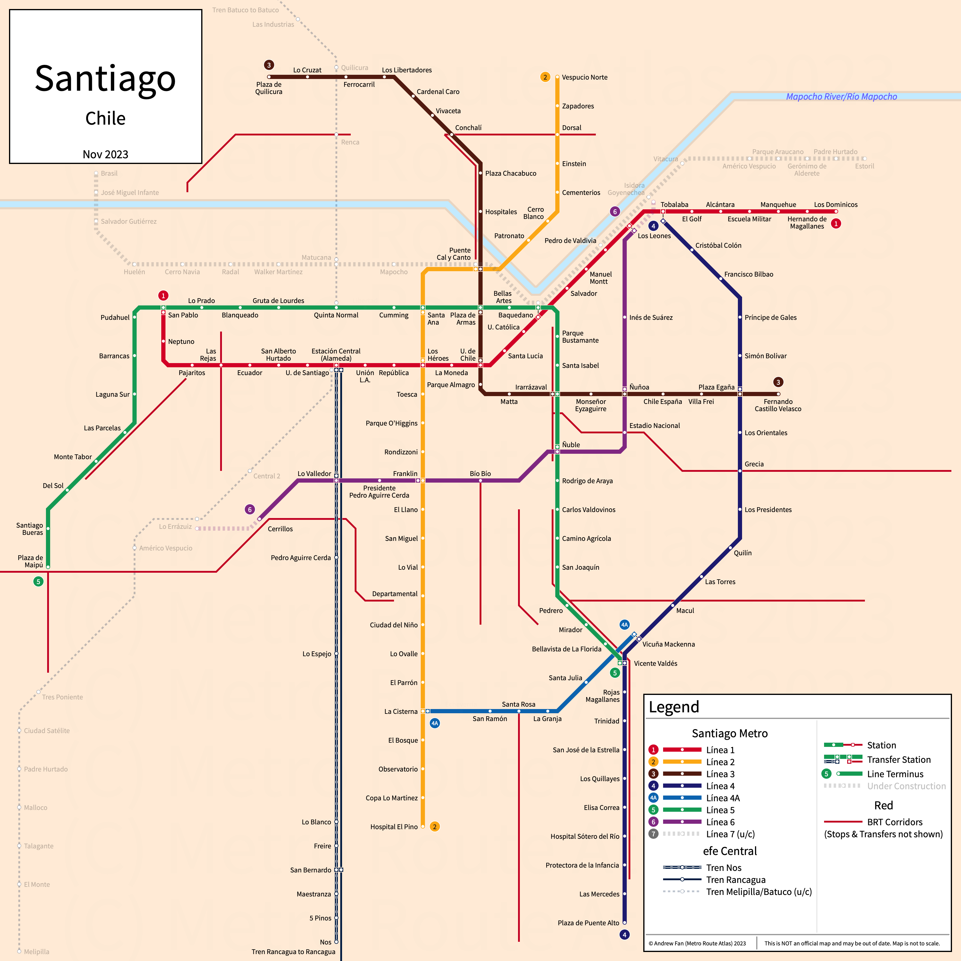
Table of Contents
Overview - Santiago
Located on the Mapocho River, Santiago is the capital of and the largest city by population in Chile. Including all satellite cities within Santiago, Santiago has approximately 6,269,000 inhabitants in the city proper as of 2017. The Santiago metropolitan area comprised 6,903,479 residents as of the 2017 INE census.
Santiago's rapid transit network consists of seven metro services, an urban mainline rail service, and a network of bus rapid transit open busways. It also has a commuter rail service.
Santiago Metro
Opened 1975, the Santiago Metro consists of seven metro services that serve the city of Santiago, Chile and the surrounding suburbs.
Line 1 (Línea 1)
Line 1 of the Santiago Metro is a metro service on an East-West alignment. It runs from San Pablo in the west to Los Dominicos in the east, serving 27 stations.
Line 1 was opened in September 1975 and the last extension to the line was to Los Dominicos in January 2010. Line 1 is owned and operated by Metro S.A.
Line 2 (Línea 2)
Line 2 of the Santiago Metro is a metro service on a North-South alignment. It runs from Vespucio Norte in the north to Hospital El Pino in the south, serving 26 stations.
Line 2 was opened in March 1987 and the last extension to the line was to Hospital El Pino in November 2023. Line 2 is owned and operated by Metro S.A.
Line 3 (Línea 3)
Line 3 of the Santiago Metro is a metro service on an L-shaped alignment. It runs from Plaza Quilicura in the north to Fernando Castillo Velasco in the east, serving 21 stations.
Line 3 was opened in January 2019 and the last extension to the line was to Plaza Quilicura in September 2023. Line 3 is owned and operated by Metro S.A.
Line 4 (Línea 4)
Line 4 of the Santiago Metro is a metro service on a North-South alignment. It runs from Tobalaba in the north to Plaza de Puente Alto in the south, serving 23 stations.
Line 4 was opened in November 2005 and the last extension of the line was the opening of the Los Presidentes-Vicuña Mackenna section in March 2006. Line 4 is owned and operated by Metro S.A.
Line 4A (Línea 4A)
Line 4A of the Santiago Metro is a metro service on an east-west alignment. It runs from La Cisterna in the west to Vicuña Mackenna in the east, serving 6 stations.
Line 4A was opened in August 2006. Line 4A is owned and operated by Metro S.A.
Line 5 (Línea 5)
Line 5 of the Santiago Metro is a metro service on an upside down U-shaped alignment. It runs from Plaza de Maipú in the west to Vicente Valdés in the east, serving 30 stations.
Line 5 was opened in April 1997 and the last extension of the line was to Plaza de Maipú in December 2011. Line 5 is owned and operated by Metro S.A.
Line 6 (Línea 6)
Line 6 of the Santiago Metro is a metro service on an Northeast-Southwest alignment. It runs from Los Leones in the northeast to Cerillos in the southwest, serving 10 stations.
Line 6 was opened in November 2017. Line 6 is owned and operated by Metro S.A.
EFE Central
Opened 2017, EFE Santiago (formerly Metrotren) consists of an urban mainline rail service and a commuter rail service that serves the city of Santiago, Chile and the surrounding suburbs.
Tren Nos-Estación Central
The Tren Nos-Estación Central is an urban mainline rail service on a North-South alignment. It runs from Alameda (Estación Central) in the north to Nos in the south, serving 10 stations.
The Tren Nos-Estación Central was opened in its current form in March 2017 as Metrotren Nos. The Tren Nos-Estación Central is operated by EFE Central.
Tren Rancagua-Estación Central
The Tren Rancagua-Estación Central is a commuter rail service on a North-South alignment. It runs from Alameda (Estación Central) in the north to Rancagua in the south, serving 10 stations.
The Tren Rancagua-Estación Central was opened in October 1990 and upgraded and rebranded to its current form in January 2017 as Metrotren Rancagua. The Tren Rancagua-Estación Central is operated by EFE Central.
Red
Red (formerly Transantiago) contains a network of bus rapid transit open busways that serve the city of Santiago, Chile and the surrounding suburbs. As true open busways, there are no dedicated stations, each corridor instead having single directional stops wherever needed to support the multitude of service patterns using the corridors. As a result of this complexity, it is impossible and impractical to produce strip maps of each corridor. In addition, as corridors are built and expanded as needed, we do not have dates for any corridors and instead have alphabetized them by primary trunk.
Corredor Departamental
The Corredor Departamental is a bus rapid transit open busway on an East-West alignment. It runs along Avenida Departamental from Avenida General Velasquez in the west to Calle Gamma in the east, and from Calle Maraton in the west to Avenida Tobalaba in the east.
Corredor Dorsal
The Corredor Dorsal is a bus rapid transit open busway on an East-West alignment. It runs along Avenida Dorsal from Jorge Hirmas in the west to Avenida El Salto in the east. The western portion is also known as Corredor Jaime Guzmán or Corredor Anillo Intermedio Norte.
Corredor Grecia
The Corredor Grecia is a bus rapid transit open busway on an East-West alignment. It runs along Avenida Grecia from Crescente Errazuriz in the west to Avenida Diagonal Las Torres in the east.
Corredor Independencia
The Corredor Independencia is a bus rapid transit open busway on a North-South alignment. It runs along Avenida Independencia from Dorsal in the north to Santa María in the south.
The Corredor Independencia opened in December 2020.
Corredor Las Industrias
The Corredor Las Industrias is a bus rapid transit open busway on a North-South alignment. It runs along Avenida Las Industrias from Avenida Carlos Valdovinos in the north to Yungay in the south.
Corredor Pajaritos
The Corredor Pajaritos is a bus rapid transit open busway on a North-South alignment. It runs along Avenida Pajaritos and Gladys Marin Millie from Nueva O'Higgins/Nueva San Martin in the south to La Colonia/Avenida 5 de Abril in the north, and then from Caletera Avenida Americo Vespucio/Presidente de Gaulle in the south to Rey Gustavo Adolfo/Manuel Rivas Vicuña in the north.
Corredor Pedro Aguirre Cerda
The Corredor Pedro Aguirre Cerda is a bus rapid transit open busway on an East-West alignment. It runs along Avenida Rinconada, 5 de Abril, Esquina Blanca, and Pedro Aguirre Cerda from Las Naciones in the west to Avenida Departamental/Avenida Suiza in the east.
Corredor Santa Rosa
The Corredor Santa Rosa is a bus rapid transit open busway on a North-South alignment. It runs along Avenida Santa Rosa from Los Manzanos/Apóstol Tomás in the south to Avenida Americo Vespucio in the north, and from Avenida Lo Ovalle in the south to Carlos Silva Vildasola in the north.
Corredor Suiza-Las Rejas
The Corredor Suiza-Las Rejas is a bus rapid transit open busway on a North-South alignment. It runs along Suiza and Las Rejas from Porto Seguro in the north to Mailef in the south, serving 8 stations.
The last extension of the line was to the north in July 2014.
Corredor Vicuña Mackenna
The Corredor Vicuña Mackenna is a bus rapid transit open busway on a North-South alignment. It runs along Vicuña Mackenna and Concha y Toro from Baron Pierre de Coubertein/Eulogia Sanchez in the north to San Hugo/San Carlos in the south.
References & Helpful Links
Santiago Metro at Wikipedia | Metro de Santiago at Wikipedia.es
Tren Nos-Estación Central at Wikipedia.es
Tren Rancagua-Estación Central at Wikipedia.es
Red at Wikipedia | Red at Wikipedia.es
Official Website for Santiago Metro: Metro de Santiago
Official Website for EFE Central: EFE
Official Website for Red: Red
Maps
All Official Maps - Metro de Santiago [Last Accessed Aug 26, 2025]
Unofficial Map - Santiago Metro [March 2018] by José Ureña (www.transitmap.net)
Unofficial Map - Santiago (Chile) [March 2026] by Enmergal (www.talahu.design)
Other Sources
Santiago, Chile at Urbanrail.net
Santiago, Chile at BRTDATA.org
Other Websites
External Citations
Asset Notes
Metro colors (1-6) taken from official metro map as of Sept 5, 2021. Metro colors (7-9) taken from Wikipedia icons as of Sept 5, 2021. EFE colors taken from EFE website strip map. Red color taken from CSS on official website as of Sept 5, 2021