Mérida, Mérida, Venezuela
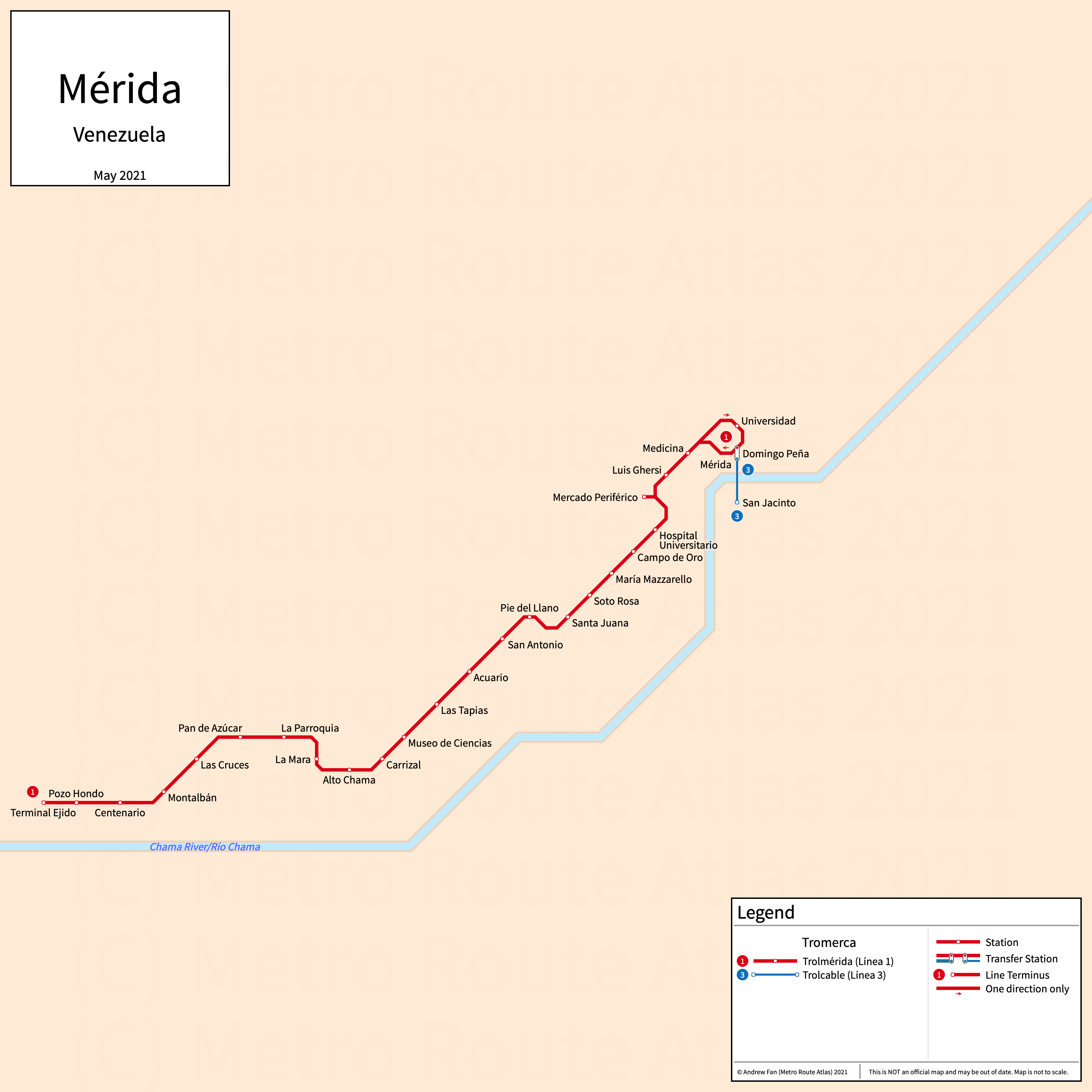
Table of Contents
Overview - Mérida
Located on the Chama River, Mérida (Santiago de los Caballeros de Mérida) is the capital of and the largest city by population in Mérida. It has approximately 200,000 inhabitants in the city proper as of 2011. The Mérida metropolitan area comprised 447.269 residents as of the 2013 INE census estimate.
Mérida's rapid transit network consists of a bus rapid transit service and a gondola lift service.
Trolmérida
Opened 2007, Trolmérida consists of a bus rapid transit service that serves the city of Mérida, Mérida and the southwestern suburbs.
Line 1 (Línea 1)
Tromerca Line 1 is a bus rapid transit service on a Northeast-Southwest alignment. It runs from Ejido in the southwest to Domingo Peña in the northeast, serving 24 stations of which two are in a single directional clockwise loop. There is an additional station in downtown Mérida (Mercado Periférico) that serves transfers and express services, which is not shown on the strip map above. As is typical in Venezuela, buses run contraflow (left hand drive) along the exclusive right of way due to having doors only on one side of the vehicle.
Line 1 was opened in June 2007 and the last extension to the line was to Domingo Peña in August 2015. Line 1 is operated by Tromerca.
Trolcable
Opened 2012, Trolcable consists of a gondola lift service that serves the city of Mérida, Mérida and the nearby suburbs.
Line 3 (Línea 3)
Tromerca Line 3 is a gondola lift service on a North-South alignment. It runs from Mérida (Domingo Peña) in the north to San Jacinto in the south.
Line 3 was opened in December 2012. Line 3 is operated by Tromerca.
References & Helpful Links
Official Website for Trolmérida and Trolcable: Tromerca
Maps
Official System Map - Tromerca [Last Accessed May 15, 2021]
Other Sources
Mérida, Venezuela at BRTDATA.org
Other Websites
External Citations
Asset Notes
Line colors taken from official 2017 Twitter map. Random pixels were used as reference due to JPEG compression.