Portland, Maine, USA
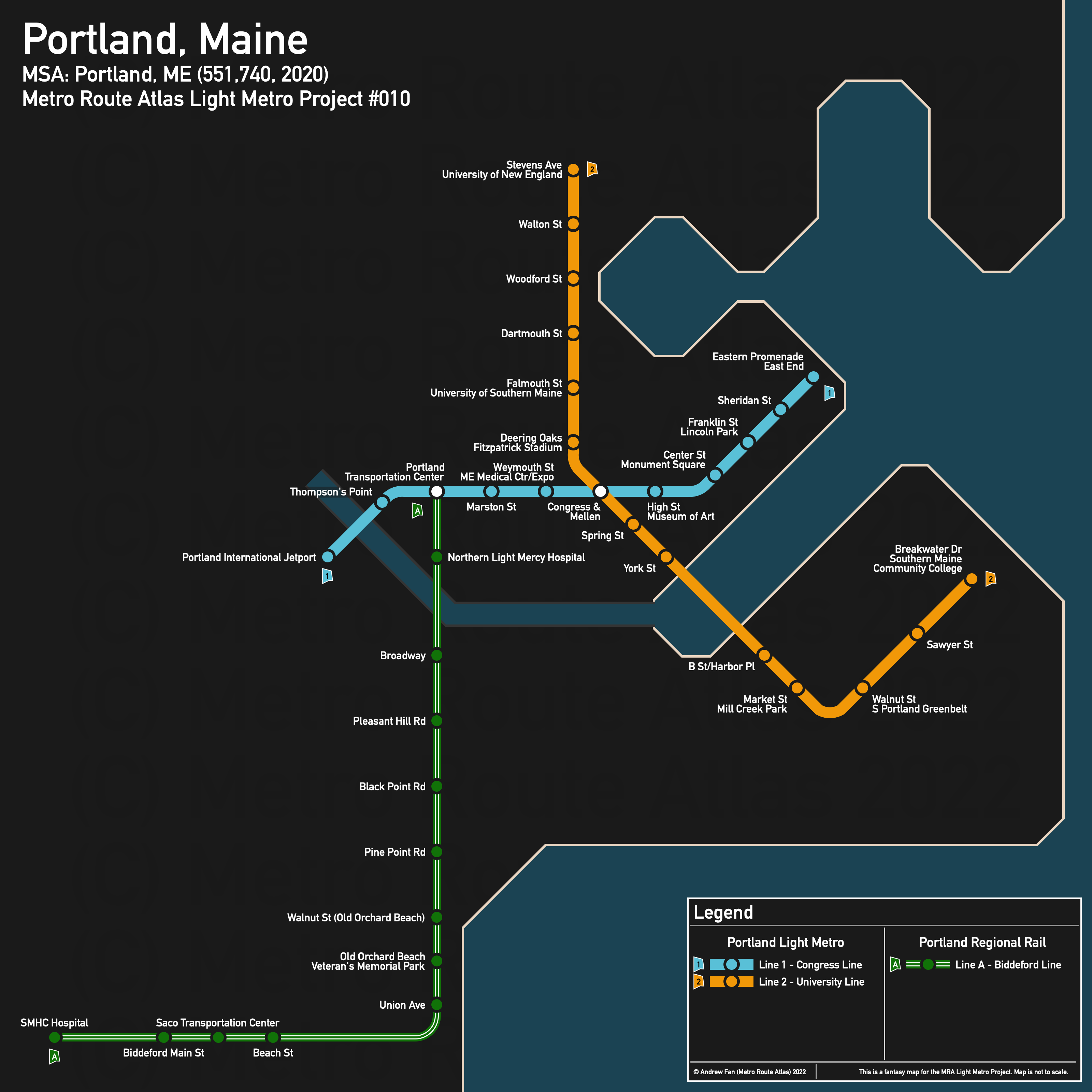
Table of Contents
Overview - Portland
Located on a peninsula in Casco Bay, Portland is the seat of Cumberland County and the largest city by population in Maine. It has approximately 68,408 inhabitants in the city proper as of 2020. The Portland metropolitan area (Portland-South Portland) comprised 551,740 residents as of the 2020 US Census.
Main universities include the University of New England (Westbrook College) and the University of Southern Maine. The main airport is Portland International Jetport. Notable stadiums include those in the Portland Sports Complex (Hadlock Field, Fitzpatrick Stadium, Portland Exposition Building) and Cross Insurance Arena. Within the Metropolitan Area, notable employment sites and universities include Freeport and other branches of the University of New England (Biddeford Campus) and the University of Southern Maine (Gorham Campus).
The city itself is surrounded by water to the north, east, and south, with I-295 cutting off the peninsula from the rest of the city and running along the north side of the peninsula across Back Cove on Tukey's Bridge.
Within the peninsula, Congress St and Washington Ave provide a continuous connection across. The main rail corridor runs north-south west of I-295 and connects to points north and south, splitting after crossing the southern bridge to form two northern 'branches' (Amtrak's Downeaster operates by reversing onto the other branch to serve the transportation center). Brighton Ave is the main east-west road while Stevens Ave and Forest Ave are the main north-south roads.
The local public transit agency in Portland is the Greater Portland METRO (System Map). The Portland Transit Center is located west of I-295, serving intercity buses and Amtrak.
Below statistics are as of the June 2022 timetable:
- Bus routes running every [0, 10] minutes during weekday off-peak:
- Bus routes running every (10, 15] minutes during weekday off-peak:
- Bus routes running every (15, 30] minutes during weekday off-peak: 1, 2, 4, 5, 8
2020 Census Tract Data suggests that most of the density is directly on or west of the peninsula, with the Saco-Biddeford area and Brunswick being very dense as well.
Network Design - Thought Process
Portland has a MSA population of 551,740 and therefore has 110 points to spend (1 point for 1 km regional rail and 5 points for 1 km light metro/new build regional rail).
For better or for worse, Portland immediately provides a conundrum, as the density is heavily concentrated on the peninsula and its surroundings, as well as Saco-Biddeford and Brunswick. The issue, is that although we have regional rail corridors in use by Amtrak, they spend long periods of time passing through... nothing. Northwest of the Portland Transportation Center, the line goes to Westbrook, but misses downtown by a 15 minute walk. Beyond Westbrook, there... isn't anything else for a long distance. To the south, the line passes through an industrial area, cemeteries, and a trainyard before running through unpopulated areas for 10 km before reaching Old Orchard Beach, Saco, and Biddeford. To the north, the line misses the University of New England, then proceeds to have catchment areas of approximately 20 houses at each following intersection before a very long stretch where it bypasses all the major towns until hitting Freeport and Brunswick. The coastal railway doesn't serve much of the peninsula since it skirts it, though it does serve the northern towns slightly better.
In short, we have three nodes of density with multiple daily Amtrak trips and intercity bus service, but which are too far away from one another. The northern corridor is the first victim here - skipping Yarmouth entirely significantly hurts potential ridership, and while Freeport is a nice town (unfortunately brick and mortar retail focused in an age of internet shopping) and Bowdoin College in Brunswick is a high source of potential ridership, the fact that METRO BREEZ (Greater Portland METRO's service between Brunswick and Portland) runs around once an hour on weekdays and the rail line bypasses Yarmouth means that it is simply not worth it to run extra service that far - in effect cutting back any line significantly. However, since even a shortened version bypasses the universities on the corridor within Portland, it makes more sense to run a light metro service along the corridor in Portland instead and actually serve the universities.
In addition to this, service to Westbrook is also suboptimal. There used to be another railway right of way in town but connecting to that ROW means bulldozing houses and properties that have since moved in, and dealing with the fact that much of it has been turned into roadways and trails. Given poor density along the route, improved bus service would probably be more than sufficient (or converting the rail corridor to an open busway and having buses serve the core of Westbrook that way). As a result, whatever regional rail we do will likely end up along the Saco-Portland corridor, which has the advantage of serving three towns directly, albeit with a lot of nothing in between Portland and Old Orchard Beach. Starting from the Portland Transportation Center in the north and ending at SMHC Hospital in the south, this corridor is 29 km, assuming it ends at a natural extension of the trail from the SMHC parking lot to the railway ROW. This leaves us with 81 points left, or 16.2 km of light metro.
The immediate core route is one from the Portland Transportation Center along Congress St to Mountfort St and then either east along Congress St or northeast along Washington Ave. The former puts the entire peninsula within the catchment area of the line, while the latter, if using the bridge, allows for connections to points north... where there is only lower density residential and a few good nodes to even put a station at. For this reason, we will use the eastern option - full length of this line, if starting north of the Portland Transportation Center building (tail tracks facing west) and cutting across the intersection to where Lowell St meets Congress St and following Congress St to the Eastern Promenade, is 4.6 km, leaving us with 11.6 km of light metro to work with.
For the north-south corridor, we can start at the University of New England at Stevens Ave and Waverly St, then going south on Forest Ave. The line turns west at Falmouth St and then south on Deering Ave, passing by the University of Southern Maine and the sports complex (4.2 km) before arriving at the existing line and sharing the ROW (on separate tracks) for half a km to State St, where it then goes down State St, uses a new bridge to reach Ocean St, and follows Broadway to Breakwater Dr and Southern Maine Community College. This is 4.7 km and although not running through the densest area, it does connect SMCC to the network and the mall area south of the Casco Bay Bridge can be used to transfer from bus to light metro in order to provide significant capacity over the water crossing. This leaves us with 2.2 km left.
Looking west, 2.2 km isn't much. From the Portland Transportation Center, half a km takes us down the west side of Thompson's Point, but if we bridge over the Fore River and dive underground to a terminus at the Portland International Jetport's main terminal, it only costs 2.1 km. The assumption for this project is that infrastructure be above ground, but in this case, we'll allow for the airport connection, which provides a one seat ride from the airport to the main transit hub, the main sports venues, and downtown Portland.
And with that, we have two light metro lines and a regional rail line. We've hit the main transit center, served the main universities in Portland proper, multiple medical centers, and have stations at the main sports venues in the city. Total light metro network length is 16.1 km and total regional rail network length is 29 km.
Portland Light Metro
The Portland Light Metro consists of two lines that meet at a stacked cross platform interchange west of downtown Portland
Line 1 - Congress Line
Line 1 of the Portland Light Metro is a 6.7 km light metro service on a East-West alignment. It runs from Portland International Jetport in the west to Eastern Promenade in the east via downtown Portland, serving 11 stations.
The line has an average station spacing of 670m.
The line is named after the corridor it runs on. The color is taken from the City of Portland's logo on their website as of August 2022.
Line 2 - University Line
Line 2 of the Portland Light Metro is a 9.4 km light metro service on a North-South alignment. It runs from the University of New England in the north to Southern Maine Community College in the south via downtown Portland, serving 14 stations.
The line has an average station spacing of 723m.
The line is named as such due to serving multiple universities. The color is taken from the University of Southern Maine's logo as of August 2022 (Wikipedia).
Portland Regional Rail
The Portland Regional Rail network consists of a single north-south line running along the Amtrak Downeaster corridor.
Line A - Biddeford Line
Line A of the Portland Regional Rail is a 29 km regional rail service on a North-South alignment. It runs from SMHC Hospital in the south to Portland Transportation Center in the north via Old Orchard Beach, serving 13 stations.
The line has an average station spacing of 2.417 km.
The line is named after the city it serves. The color is taken from the logo of York County as of August 2022 (Wikipedia).
Realistic Applications
For all practical purposes, it is essentially impossible to do any elevated railways in downtown Portland due to the narrowness of the streets and the impact such a thing would have on the surrounding environment. That being said, downtown Portland can get very congested and the Line 1 corridor is very convenient for tourists during the summer high season as well as locals trying to connect to intercity transportation without a car (or bus stuck in traffic). Line 2's northern half has a lot of potential due to connecting the universities to the downtown core and providing additional capacity at the stadiums, but anything south of the river is unlikely to be useful for most people unless South Portland sees high population growth that tests the capacity of the Casco Bay Bridge (or downtown Portland, for that matter).
As for the regional lines, distances are great enough and populations small enough that such a Portland-centric service likely wouldn't be very competitive, but additional Brunswick-Saco services that run in between Downeaster services may be a good way to test if demand for more frequent service centered around Portland rather than Boston is desirable. It's worth noting that in the 2020-2050 Transit Tomorrow (March 2021) plan, increasing Downeaster service is mentioned.
It's also worth mentioning that nearly every long term plan for the Downeaster includes moving the Portland Transportation Center so that the Downeaster doesn't need to reverse out of the station. I did not take a future location into account mainly because it still hasn't been determined, and because the land currently used for the Transportation Center can always be redeveloped into high density housing or something else that would benefit from a higher capacity rapid transit option.
Note: I took the liberty of using the City of Portland's Logo shape for the line bullets. The shape was simply asking for it to be done, and I found it irresistible. I apologize to any Portlanders who do not like the shape.
References & Helpful Links
External Citations