Akron, Ohio, USA
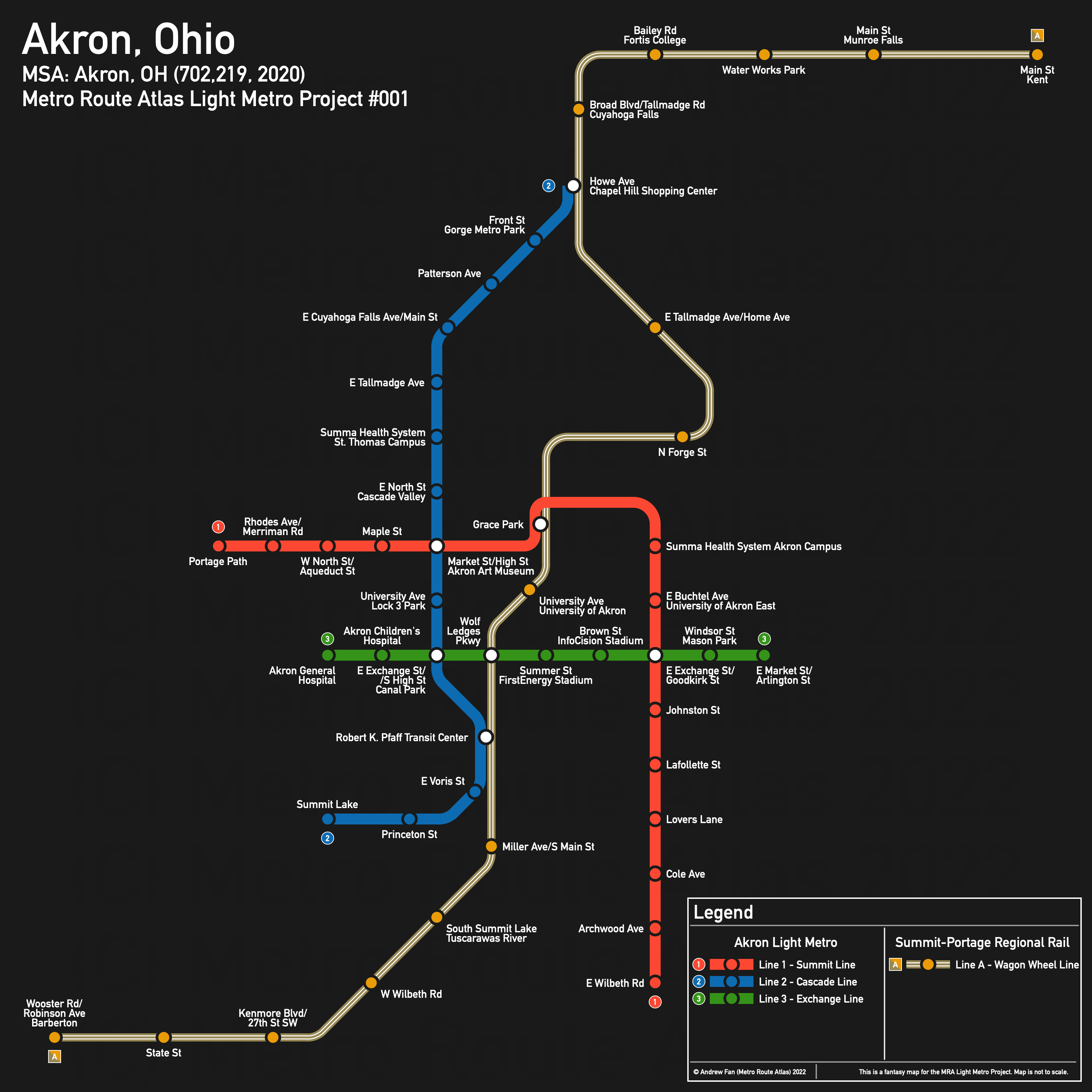
Table of Contents
Overview - Akron
Located on the western portion of the Glaciated Allegheny Plateau and south of Cleveland, Akron is the seat of Summit County and the fifth largest city by population in Ohio. It has approximately 197,597 inhabitants in the city proper as of 2019. The Akron metropolitan area comprised 702,219 residents as of the 2020 US Census.
As of 2020, the main non-government employers in Akron were the Summa Health System, University of Akron, Akron Children's Hospital, Cleveland Clinic - Akron General, Goodyear Tire & Rubber Company, FirstEnergy, and Signet Jewelers. Main universities include the University of Akron. The main airport is Akron-Canton Regional Airport. Notable stadiums include InfoCision Stadium, Canal Park, James A. Rhodes Arena, and FirstEnergy Stadium. Within the Metropolitan Area, Kent State University is a major university and employment center.
Akron's downtown is surrounded by limited access roads - Highway 59 on the west, I-76 on the south, and Highway 8 on the east. A river and rail corridor (Cascade Valley) run north of downtown, separating it from the neighborhoods on the north side.
The main north-south road corridor is Main Street-High St/Broadway. These use the All American Bridge to cross the Cascade Valley north of downtown. Market Street, and to a lesser extent Exchange Street/Cedar Street, are the main east-west road corridors, crossing both freeways and the rail corridor that separates downtown from the University of Akron.
The local public transit agency in Akron is the METRO Regional Transit Authority (RTA) (System Map (Jan 2022)). There are three transit centers - the Robert K. Pfaff Transit Center in downtown (which also serves intercity buses), the smaller Rolling Acres/Romig Road Transit Center in the southwest part of the city, and the Independence Transit Center at Chapel Hill Mall in the northeast. In Kent, the local public transit agency is the Portage Area Regional Transportation Authority (PARTA), which has its transit center at Erie and Depeyster.
Below statistics are as of the Winter 2022 RTA timetable:
- Bus routes running every [0, 10] minutes during weekday off-peak: None
- Bus routes running every (10, 15] minutes during weekday off-peak: None
- Bus routes running every (15, 30] minutes during weekday off-peak: 2, 3, 6, 8, 10, 14
2020 Census Tract Data suggests that most of the density is in the northern half of Kenmore, south of downtown, west of Highway 8/59 leading to Cuyahoga Falls, and along the Market/Exchange corridor in the northwest.
Network Design - Thought Process
Akron has a MSA population of 702,219 and therefore has 140 points to spend (1 point for 1 km regional rail and 5 points for 1 km light metro/new build regional rail).
In terms of corridors, the rail corridor separating downtown misses most of the density on the north side of the valley but is excellently positioned for stations at Cuyahoga Falls and Kent, where a station could be within a 15 minute walk of the heart of Kent State University. On the south end, service as far as Barberton is feasible. The important point is that the corridor hits two universities, the main transit center and intercity bus terminal, and the heart of downtown Akron, meaning that the opportunity to use this corridor is just too good to pass up. From Wooster/Robinson in the Barberton to Main Street in Kent, the corridor is 31.5 km long.
For the urban network within Akron, we have 21.7 km remaining for light metro. In terms of hitting the density, we definitely want to hit the Market St corridor, connect to the Summa Health System Akron Campus, and serve the denser southern part of the city. Going south, there are two possible corridors - Arlington St and Highway 8/I-77. Arlington St is not exactly wide enough to shove a concrete guideway in, so the I-77 corridor it is. The question is how far it goes in each direction. For the core of the route, Portage Path down Market to the rail ROW, up to Perkins St, down Perkins St to Fountain St, down the highway, and then crossing over to the west side north of Carroll to serve the University of Akron's east side, and down the highway to Wilbeth Rd is around 9 km. This route detours along the rail ROW in order to provide a quality interchange as well as get some room to reach the Summa Health System Akron Campus on the way to the southern parts of town. As for potential extensions, extending south from Wilbeth Rd to Waterloo Rd is another 1.2 km, while extending northwest from Portage Path to Frank Blvd is 3.1 km.
The rail corridor, as mentioned prior, misses the denser parts of the north side of the valley and misses the western half of downtown. So a north-southwest corridor seems like a good idea. Starting where Howe Ave meets the rail corridor (a transfer station offers better connectivity, so it's worth reaching out to this point, which is also a destination and employment center), the route can go down Cuyahoga Falls Ave to Main, then down Main (High St in downtown) to Rosa Parks Dr and the transit center. From here, continuing south on Broadway to I-76, and turning west, we go until Lake Shore Blvd. This is a 9 km route. We could extend further west, but we would not have enough trackage left to make it to the small and isolated Rolling Acres Transit Center regardless of the options chosen for the first line, so we will end the route here.
Finally, we've neglected the Exchange corridor. We only have 3.7 km left (and less if we take one of the extensions for the first light metro line). This is enough to reach from Akron General Hospital in the west to the junction of Exchange, Arlington, and Market in the east, along Exchange. The section east of Highway 8 could be attached to the other side of the route instead and go to the Zoo, but that would be parallel to the Market corridor, while the east side has no service, so we will keep it on the east.
And with that, we have three light metro lines and a regional rail line. We've hit the main transit center, served the 30k students and supporting staff + faculty of the University of Akron, served the 41k students and supporting staff of Kent State University (sort of), served Summa Health System's Akron Campus, Akron Children's Hospital, and the Cleveland Clinic - Akron General, and have stations at InfoCision Stadium, Canal Park, and FirstEnergy Stadium. Total light metro network length is 21.7 km and total regional rail network length is 31.5 km.
Akron Light Metro
The Akron Light Metro consists of three separate lines with no branches forming a soviet triangle within downtown Akron. Line 1 primarily runs on the Market and I-77 corridors, while Line 2 primarily follows Main/High and Line 3 primarily runs on Exchange. There are no missed transfers, and all three lines connect to the Regional Rail network.
Line 1 - Summit Line
Line 1 of the Akron Light Metro is a 9.0 km light metro service on an Northwest-South alignment. It runs from Portage Path in the northwest to E Wilbeth Rd in the south via Downtown Akron, serving 15 stations.
The line has an average station spacing of 643 meters. While the route could be straighter, a detour at Grace Park offered a higher quality connection with the regional rail and allowed for a cleaner approach to the Summa Health System Akron Campus. Buchtel and Exchange stations are located on the west side of the highway to make it easier to access the university. Station spacing on the southern portion is frequent due to lack of cross streets over highway and attempting to not miss bus connections.
The line is named after the county. There is no significance behind the color.
Line 2 - Cascade Line
Line 2 of the Akron Light Metro is a 9.0 km light metro service on a North-South alignment. It runs from Chapel Hill Shopping Center in the north to Summit Lake in the south via Downtown Akron, serving 14 stations.
The line has an average station spacing of 602 meters. The station at University Ave and Lock 3 Park is close to the others but serves a number of destinations.
The line is named after the valley it crosses. The color blue is inspired by the river it crosses and Summit Lake, where it terminates.
Line 3 - Exchange Line
Line 3 of the Akron Light Metro is a 3.7 km light metro service on an East-West alignment. It runs from Akron General Hospital in the west to East Market St/Arlington St in the east, serving 9 stations.
The line has an average station spacing of 463 meters. This is due to the number of destinations along the corridor, most of which are stadiums or hospitals, which benefit from shorter walking distance in order to maximize the potential for patrons to use the service.
The line is named after the street on which it travels. There is no significance behind the color.
Summit-Portage Regional Rail
The Summit-Portage Regional Rail consists of a single service running entirely along an existing rail corridor from Barberton in the southwest to Kent in the northeast. It offers interchanges with all three light metro lines.
Line A - Wagon Wheel Line
Line A of the Summit-Portage Regional Rail is a 31.5 km regional rail service on an Northeast-Southwest alignment. It runs from Beaverton in the southwest to Kent in the northeast via Downtown Akron, serving 18 stations.
The line has an average station spacing of 1.853 km. While a few of the stations are not likely to serve much in terms of ridership, they open up the network to more people and if good timed connections are provided by bus operators, can provide substantial benefit by speeding up journeys.
The line is named after the trophy for the football rivalry between the University of Akron and Kent State University, both of which are served by the line. The colors are taken from the logos of the two teams.
Realistic Applications
Put bluntly, Akron has lost 100,000 people since its height in the 1960s. It has lost population in every census since 1970. If the current trend continues with Rust Belt depopulation, Akron will continue to decline. That being said, there's still hope for the future, and there's nothing saying that Akron cannot rebound from its current state.
Of the lines I drew on the map, there's a standout - I mentioned it prior. The rail corridor running through downtown Akron, at least the northern portion between Akron's Transit Center and Kent, hits so many key destinations that even a takt half hourly service with timed transfers at the transit center (again, the rail corridor is literally next to the city's hub-spoke transit center/intercity bus terminal) would provide an incredibly useful service. It may not match the PARTA shuttle between the two universities in directness, but it would serve many more people.
As for the other corridors, Line 1 could probably be implemented as an arterial BRT route on a 15 minute frequency, with both of the extensions I cut actually used. Fixed guideway transit pretty much has to be grade separated since there isn't enough space in the ROW. Line 2 has a similar story, but could be extended west. Line 3 was designed to hit the main destinations on the corridor - it doesn't actually hit much density. For better or for worse, if a supporting feeder network is present, this might actually be the only corridor worth implementing as a light metro (or in this case, a glorified people mover). Its main job is to connect the main employment hubs and destinations in downtown, after all, and it can do so rapidly and efficiently. But extensions would definitely be necessary in order for it to be useful as a regional trunk line.
References & Helpful Links
External Citations