Port St. Lucie, Florida, USA
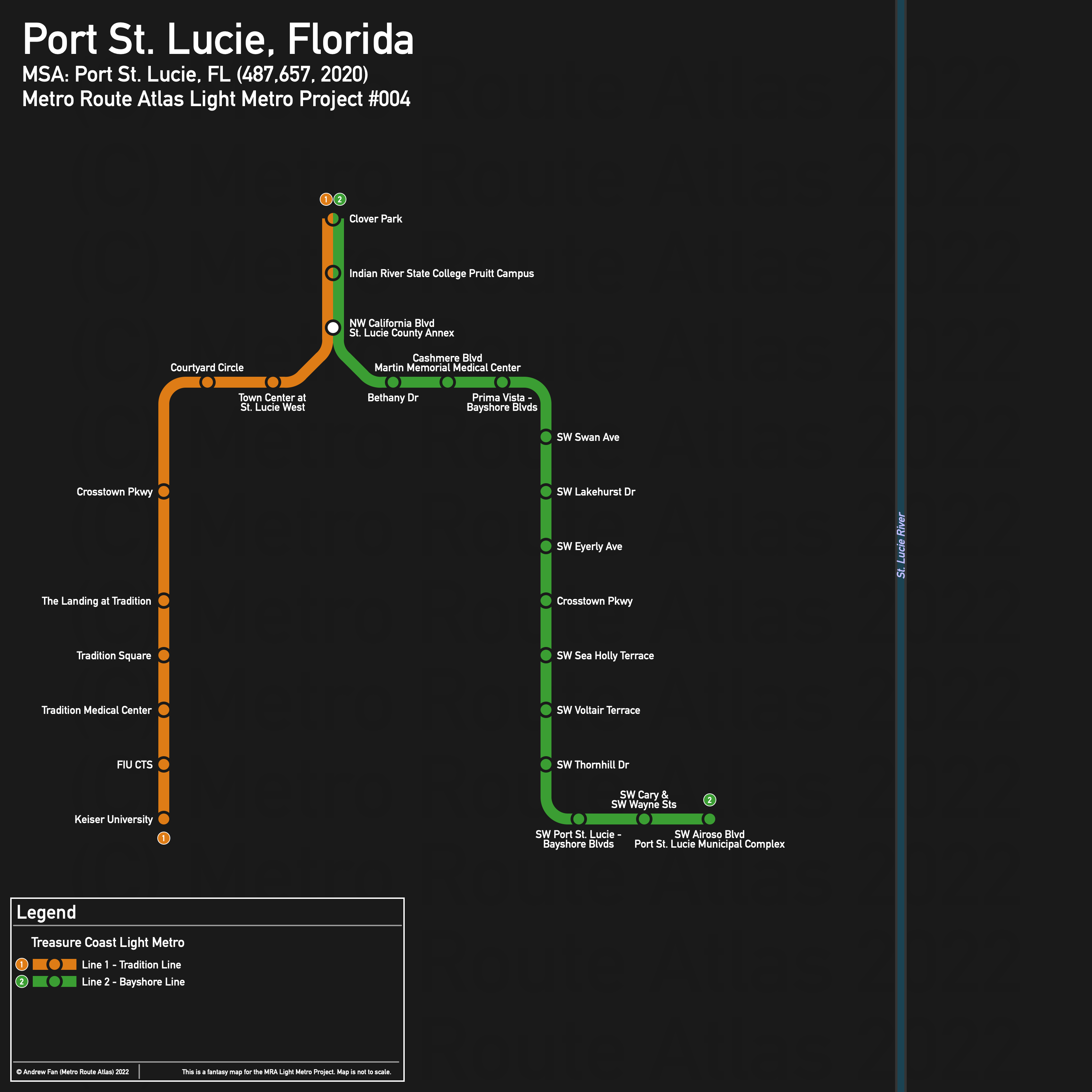
Table of Contents
Overview - Port St. Lucie
Located on the St. Lucie River and separated from the Atlantic Ocean by a lagoon and barrier island, Port St. Lucie is the seventh largest city by population in Florida. It has approximately 204,851 inhabitants in the city proper as of 2020. The Treasure Coast metropolitan area comprised 487,657 residents as of the 2020 US Census.
As of 2020, there are no main non-government employers in the Treasure Coast with more than 2000 employees besides Indian River State College, which itself is split across multiple cities in the area . Indian River State College is the only major university in the metropolitan area. There are no major airports or stadiums in the metropolitan area.
Port St. Lucie is split east-west by the St. Lucie River, with the Florida Turnpike and I-95 also running north-south and splitting up the city. The Florida East Coast Railway runs along the coast between Stuart and Fort Pierce, completely bypassing Port St. Lucie.
Major east-west roads include Prima Vista Blvd, Crosstown Parkway, and Port St. Lucie Blvd, the only three crossings of the St. Lucie River in the city area. The only major north-south road is US-1/Federal Highway, with Airoso Blvd, Bayshore Blvd, and Lennard Rd also acting as north-south arteries
The local public transit agency in Port St. Lucie is SLCRide (Area Regional Transit) Treasure Coast Connector, operated by the county.
Below statistics are as of whatever timetables were available on January 21, 2021:
- Bus routes running every [0, 10] minutes during weekday off-peak: None
- Bus routes running every (10, 15] minutes during weekday off-peak: None
- Bus routes running every (15, 30] minutes during weekday off-peak: 1
2020 Census Tract Data suggests that most of the density is within the residential zones in Port St. Lucie between I-95 and the river. Densities are noticeably lower around the US-1 corridor except up at Fort Pierce.
Network Design - Thought Process
Port St. Lucie has a MSA population of 487,657 and therefore has 98 points to spend (1 point for 1 km regional rail and 5 points for 1 km light metro/new build regional rail).
First, we must state the obvious. Port St. Lucie is a post-war sprawling mostly residential area with destinations located quite far from one another. The US-1 corridor has the highest frequency bus route in the entire county, but there is little density along this corridor, with literal nothing and undeveloped land surrounding large portions of the corridor. The Florida East Coast Railway might have Brightline in the future, but the alignment runs far away from inhabited areas, meaning that it's great for an intercity service between Fort Pierce and Stuart but awful for anything else within the metropolitan area. In fact, it misses most of Fort Pierce and is only useful for local transit within the Stuart area, which is far too small to justify a frequent rail service along a highway/industrial corridor. There is a rail corridor running between Fort Pierce and Port St. Lucie (FEC K Branch), but it completely bypasses most of Port St. Lucie and primarily runs through low density and undeveloped land.
We are therefore constrained to 19.6 km of new build light metro. As for where to build it, there are two logical east-west corridors (St Lucie W Blvd-Prima Vista Blvd; Gatlin Blvd-Port St Lucie Blvd) and three logical north-south corridors (I-95; Bayshore Blvd/Florida Turnpike; US-1). Crosstown Pkwy has almost nothing nearby despite being a major east-west corridor. In the west, where the new development is, Tradition and St. Lucie West have the majority of the destinations, but these are located so far from one another that it makes Las Colinas in Irving, TX look like Tokyo.
To be blunt, there is no way to build two east-west lines to US-1 from the western developments within our budget of around 20 km. Using the southern east-west corridor from Keiser University to US-1, wrapping around the lake and the straightest lines possible to get from the subdivision to Gatlin Blvd, the route is already 15.6 km. There isn't even an eastern anchor, given that the medical center is farther up the highway. This also ignores the fact that literally none of the houses in the subdivisions have sidewalks, and so catchment areas of any potential station are awful. It's 12.7 km if we cut back to Westmoreland Blvd and only 10.3 km if we cut back to Arioso Blvd and the Port St. Lucie Municipal Complex. But the corridor between Tradition and the municipal complex simply doesn't have enough demand to support such a line.
Looking at St. Lucie West, the northwest quadrant holds most destinations. But most of these are only accessible by car, as there is no sidewalk network except along arterials here. That being said, Clover Park, Indian River State College's Pruitt Campus, and the Town Centre at St. Lucie West mall are fairly close together.
In the end, there are no good routes given our limited route length. We will therefore do a three corridor approach to try and make the most of what we have. First, from the Port St. Lucie Municipal Complex at SW Port St. Lucie Blvd and SW Airoso Blvd, our first corridor heads west to Bayshore Blvd, then takes it north to Prima Vista Blvd, then follows Prima Vista Blvd/St. Lucie W Blvd to NW Country Club Drive, where it continues to the roundabout at NW California Blvd. This is 9.4 km.
Our second corridor goes west from here, hugging the south side of the Walmart, and taking NW Courtyard Circle between the SuperPlay and Holiday Inn to the roundabout. It then crosses the creek and curves into the median of I-95, taking it south. There are two alternatives once we get further south though - one that serves a residential area by crossing to the east side north of Crosstown Pkwy to use the utility corridor to SW Gatlin Blvd, and one that follows I-95 further, crossing over the creek at SW Lamb Ave to squeeze between two buildings at the Landing at Tradition. For the utility corridor alternative, at SW Gatlin Blvd, the corridor continues west, and as soon as it has passed the buildings on the south side, it cuts over straight to the north side of the lake, between the lake and Tradition Surgery Center. It hugs the lake's north and west sides, and at the corner cuts between the VITAS Healthcare and Cleveland Clinic research building to make a beeline for the north side of Keiser University's campus. The Tradition alternative cuts across the parking lot, joining SW Village Pkwy between SW Meeting St and SW Stephanie Way, and takes it down to SW Innovation Way, where it cuts over and runs down the west side of the lake, continuing the alignment. This portion of the corridor is 9.1 km regardless of alternative. The Tradition alternative is preferred as the utility corridor honestly does not serve many people or destinations. This leaves us with 1.1 km remaining.
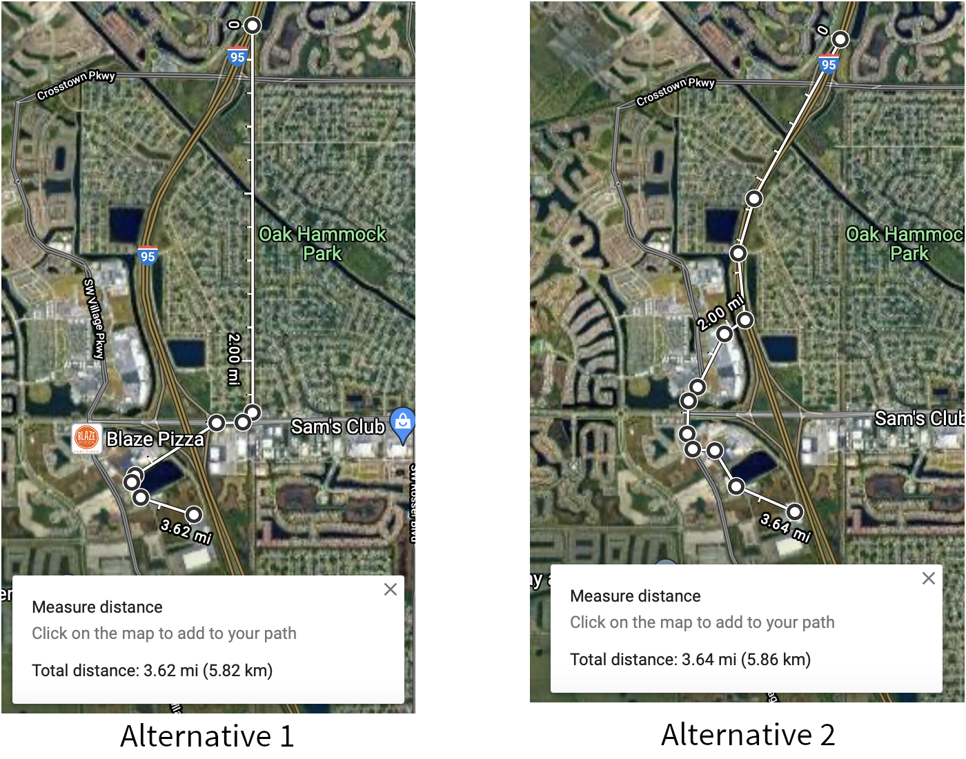
Alternatives (simple overview). Alternative 1 uses the utility corridor while Alternative 2 uses I-95
For this last segment, we return to the roundabout at NW Country Club Drive and NW California Blvd, this time heading north. At NW University, if we follow NW California Blvd up, it is 1.1 km to the Indian River State College campus. Alternatively, if we go west to the next intersection and cut across the woods, it is around 1.1 km to Clover Park. Or, since we're ignoring ROW issues, we can cut across the water and parking lot to the roundabout next to the pondside parking lot, then cut across the forest to Clover Park. At this distance, it's probably OK to say that we've served 'both' by making the students walk across that path across the pond to the station.
It's not the best network, but it works for what we have.
Treasure Coast Light Metro
The Treasure Coast Light Metro is shaped like a horseshoe with a spur sticking out from the arc. As for operations, we will have two services - one from Clover Park to Keiser University, and one from Clover Park to the Port St. Lucie Municipal Complex. We could do a third service to fill the remaining capacity but the alignment makes it uncompetitive compared to driving, and a single island platform at the transfer point is more than sufficient to handle transfers.
Line 1 - Tradition Line
Line 1 of the Treasure Coast Light Metro is a 10.2 km light metro service on a North-South alignment. It runs from Clover Park in the north to Keiser University in the south, serving 11 stations.
The line has an average station spacing of 927 meters due to a large section being on I-95.
The line is named after Tradition, the main destination. The color of the line is taken from the city seal of Port St. Lucie on Wikipedia.
Line 2 - Bayshore Line
Line 2 of the Treasure Coast Light Metro is a 10.5 km light metro service on a Northwest-Southeast alignment. It runs from Clover Park in the northwest to the Port St. Lucie Municipal Complex in the southeast, serving 16 stations.
The line has an average station spacing of 700 meters.
The line is named after the corridor it runs on. The color of the line is taken from the city seal of Port St. Lucie on Wikipedia.
Realistic Applications
To be perfectly blunt, I don't see any of the plans outlined here ever coming to fruition in any way, shape, or form. Port St. Lucie is a postwar car-dependent city with almost no public transit, limited sidewalks in residential areas (you literally cannot walk to your neighbor's house without sharing space with cars), and destinations scattered so far away from one another that transit becomes even less effective.
What Port St. Lucie DOES have is a weak arterial grid with some good trunk corridors. Even if this proposal is a flop, a Brampton style arterial bus rapid transit system may be a possibility. And honestly, getting even that much would be a major accomplishment.
Also: Running autonomous shuttles across the intersection of SW Tradition Pkwy and SW Village Pkwy is an accomplishment. If TIM's autonomous shuttles can cross that safely, the future of autonomous buses is looking bright.
References & Helpful Links
External Citations