Stockton, California, USA
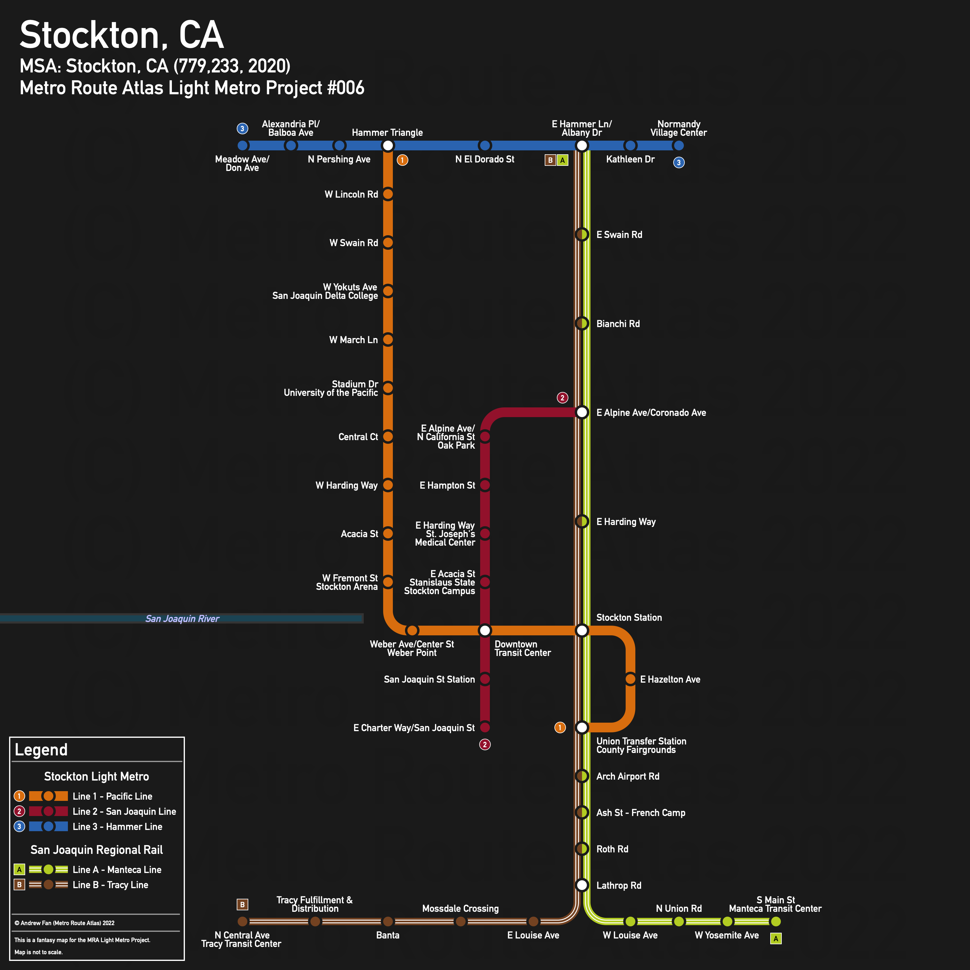
Table of Contents
Overview - Stockton
Located in California's Central Valley on the San Joaquin River, Stockton is the seat of San Joaquin County and the 13th largest city by population in California. It has approximately 320,804 inhabitants in the city proper as of 2020. The Stockton metropolitan area comprised 779,233 residents as of the 2020 US Census.
As of 2020, the main non-government employers in Stockton included St. Joseph's Medical Center and Kaiser Permanente. Main universities include the University of the Pacific, San Joaquin Delta College, and California State University Stanislaus Stockton Campus. The main airport is Stockton Metropolitan Airport. Notable stadiums include Banner Island Ballpark and Stockton Arena.
With farmland to the east and west, the Stockton Metropolitan area from Lodi in the north to Tracy and Manteca in the south is very north-south oriented, with I-5 on the west side of Stockton and the Crosstown Freeway running east-west south of downtown. The San Joaquin River runs straight into downtown, with the port to the west.
There are two north-south rail corridors that join north of downtown, then head south. This corridor is served by the Altamont Corridor Express to San José. East-west there is another railway line that serves the Amtrak station but not much else. Major north-south roads include Pershing Av, El Dorado St, California St, and West Ln/Airport Way. Major east-west roads include Hammer Ln, March Ln, Weber Av, and Charter Way.
The local public transit agency in Stockton is the San Joaquin Regional Transit District (RTD) (System Maps). There is a Downtown Transit Center (which also serves intercity buses) as well as three transfer stations at Union (Charter Way/Airport Way), Hammer (Hammer Ln/Lower Sacramento Rd), and Mall (San Joaquin Delta College, Pacific/Yokuts). They operate a 'bus rapid transit' network of five routes, though they are really just ordinary limited stop buses with a new splash of paint.
Below statistics are as of February 2022 timetable:
- Bus routes running every [0, 10] minutes during weekday off-peak:
- Bus routes running every (10, 15] minutes during weekday off-peak: 40, 43, 44, 47, 49
- Bus routes running every (15, 30] minutes during weekday off-peak:
2020 Census Tract Data suggests that most of the density is between I-5 and the rail ROW that runs through the city, with the vast majority of the population located north of Crosstown Freeway. Lodi, Manteca, and Tracy also have relatively compact cores.
Network Design - Thought Process
Stockton has a MSA population of 779,233 and therefore has 156 points to spend (1 point for 1 km regional rail and 5 points for 1 km light metro/new build regional rail).
First thing's first. Regional Rail. The Altamont Corridor Express has three stations in the region - Stockton, Lathrop/Manteca, and Tracy. The latter two stations are in the middle of nowhere, and so for all practical purposes, we will ignore the fact that the ACE even exists - both Tracy and Manteca have railroads running through them and those ROWs are far superior. That being said, Tracy has a line split and development there is allergic to the rail line, meaning that it's a much harder case to serve, especially since it's quite far from Stockton (32.6 km along rail ROW from Tracy Greyhound to Stockton Station). There's also not much between Tracy and Lathrop, and the south side of the metro area, as mentioned prior, has much worse density within Stockton itself. On the flip side, the portion within Stockton runs next to California State University Stanislaus Stockton Campus, Oak Park (admittedly, the less important side), and Kaiser Permanente (sort of). That being said, the corridor to Lodi runs through nothing in particular.
Tracy Transit Center to Stockton is 32.6 km long. Manteca Transit Center to the Lathrop Diamond is 5 km - 15 km more to Stockton Station via the ACE corridor. It is 7.5 km from Stockton Station to Hammer Lane on the western northbound rail corridor. Service to Lodi is an option, 17.7 km to the junction with the aforementioned line. We'll keep these in mind, but will focus on light metro for now.
The immediate obvious thing to do is to convert Route 40 to light metro. Hammer Ln in the north down Pacific Av, south along Madison St, around the lake to Weber Av, and then east to Stockton ACE. From here following the 44 route down S Airport Way to Second St, terminating between the transfer station and service the fairgrounds seems to be reasonable. This is 11.7 km, or 58.5 of our points, leaving 97.5 points left.
In order to connect California State University Stanislaus Stockton Campus and the Amtrak station, we propose a line starting from Oak Park at Alpine Av in the north, running down California St to the Crosstown Freeway, then going west to San Joaquin St and south to Charter Way. This line is 5 km long and eats 25 points, leaving us with 72.5 points.
From here we have some options - we can extend the existing lines, add a new one, or add regional rail. If we add regional rail, we want extend lines to connect to it. Let's first consider Kaiser Permanente and another Hammer Lane connection. As mentioned earlier, a regional rail connection uses 7.5 points, while extending our second metro line from Oak Park using the West Ln corridor and Alpine Av is 5 km, or 25 points. The West Ln corridor is quite awful as far as destinations and density are concerned, with parking lots and actual empty lots adjacent to the corridor. Since the rail corridor is equally bad but five times cheaper, the rail corridor is more promising. Therefore, we will take the Hammer Ln - Stockton Station rail corridor (7.5 points) as well as a metro extension from Oak Park to connect to the line (500m, 2.5 points). This leaves us with 62.5 points.
One thing that we didn't mention prior was that instead of using the ACE right of way from the Lathrop Diamond to Stockton, we could also use the ROW that goes through the core of Tracy for a Manteca service. Using this ROW, it is 14.5 km from Stockton Station to Lathrop Rd. From here it is 6.4 km to Manteca Transit Center and 18 km to Tracy Transit Center. This is 38.9 points used to connect to both cities, leaving 23.6 points left.
We can perform a number of extensions with this, or even build new lines. Rail to Lodi fits within the amount of points we have remaining, for example. An extension of our second metro corridor can go as far as Carolyn Weston Blvd using El Dorado St, W 8th St, and the utility corridor. We could also build a new light metro line along Hammer Ln from Kelley Dr in the west to the rail transfer in the east, or from Meadow Ave in the west to the West Ln Frontage Rd in the east. It's also sufficient for a Thornton Rd extension of our first corridor to A G Spanos Blvd (northern loop).
Of these, Hammer Ln may be one of the few corridors in the city to deserve frequent bus service, but its location means that the corridor would be suited for local trips, for which the bus does a good enough job (albeit in traffic). The Weston Ranch extension does not have the best density or street grid, and is not competitive with I-5 (I-5's typical traffic does not seem to be too bad). There also just isn't as much near it due to being bordered by the river, farmland, and industrial areas, meaning that compared with the other metro extensions, the comparative feeder ridership is lower. The Thornton Rd extension has better integrations into the street grid and therefore a larger catchment area but it is predominantly single family residential with almost no destinations (i.e. trains running empty in both directions during midday hours). As mentioned prior, the corridor to Lodi does not run through enough to make it worthwhile.
And so in the end we create a third line along Hammer Ln from Meadow Ave in the west to the West Ln Frontage Rd in the east. It may be serving strip malls but it does have a good catchment area and serves a decent number of smaller employment centers (as well as the strip mall and Costco, which, as I write this at 9 PM Pacific time on a Wednesday, apparently has bumper to bumper traffic on that Frontage Road).
It may not be the best or most balanced network, but our three light metro service and two regional rail service network serves the three main universities, multiple health centers, downtown, both intercity rail stations, and more.
Stockton Light Metro
The Stockton Light Metro has an unusual topology with two primarily north-south lines meeting at the Downtown Transit Center, and an additional line serving as a local distributor and feeder connected to the end of one of the lines.
Line 1 - Pacific Line
Line 1 of the Stockton Light Metro is a 11.7 km light metro service on a North-South alignment. It runs from Hammer Triangle in the north to Union Transfer Station - County Fairgrounds in the south via the Downtown Transit Center and Stockton Station, serving 15 stations.
The line has an average station spacing of 836 meters.
The line is named after the corridor it runs on as well as the university served. The color is taken from the University of the Pacific wordmark on Wikipedia as of February 17, 2022.
Line 2 - San Joaquin Line
Line 2 of the Stockton Light Metro is a 5.5 km light metro service on a North-South alignment. It runs from E Alpine Ave/Coronado Ave in the north to E Charter Way/San Joaquin St in the south via the Downtown Transit Center, serving 8 stations.
The line has an average station spacing of 786 meters.
The line is named after the county and the intercity rail station it serves. The color is taken from the Stanislaus State shield on their website as of February 17, 2022
Line 3 - Hammer Line
Line 3 of the Stockton Light Metro is a 4.7 km light metro service on an East-West alignment. It runs from Meadow Ave in the west to Normandy Village Center in the east via Hammer Triangle, serving 8 stations.
The line has an average station spacing of 671 meters.
The line is named after the corridor it runs on. The color is taken from the City of Stockton's S logo on the city's website as of February 17, 2022.
San Joaquin Regional Rail
The San Joaquin Regional Rail network consists of two interlined services that serve the cores of outlying cities in the southern part of the metro area and interline within the core of Stockton to provide a more frequent service.
Line A - Manteca Line
Line A of the San Joaquin Regional Rail is a 28.4 km regional rail service on a North-South alignment. It runs from E Hammer Ln/Albany Dr in the north to Manteca Transit Center in the south via Stockton Station, serving 15 stations.
The line has an average station spacing of 2.03 km.
The line is named after the city it runs to. The color is taken from the leaf on the San Joaquin County logo as of February 17, 2022.
Line B - Tracy Line
Line B of the San Joaquin Regional Rail is a 40 km regional rail service on a North-South alignment. It runs from E Hammer Ln/Albany Dr in the north to Tracy Transit Center in the south via Stockton Station, serving 16 stations.
The line has a station spacing of 2.67 km mainly due to long gaps on the way to Tracy.
The line is named after the city it runs to. The color is taken from the City of Tracy's logo.
Realistic Applications
First thing's first - the Altamont Corridor Express's stations at Tracy and Lathrop/Manteca are so far away from the cities the stations are named after that a dishonorable mention needs to be provided. I get that the ROW across the mountains is not optimal, but still.
That aside, the first line of the metro network is feasible. It runs along an established corridor connecting three transit hubs, two fairly large universities, and the main stadiums of the city. The main concern is stop spacing - RTD's express services run with much larger station spacing than the proposed metro. For example, instead of stops at W Lincoln and W Swain, it stops at W Benjamin Holt. Personally, I think the speed gains from not having to wait as long for the bus + not having to wait at intersections as well as the reliability gains from not dealing with traffic mean that more people can be directly served (higher stop density) within the same travel time using the metro, meaning that the express service can be directly replaced and the vehicles/operators transferred to providing better connecting/feeder service. The second metro line does not duplicate an existing express route and runs within walking distance of the first line, but provides much better service to the medical area and California State University Stanislaus Stockton Campus, meaning that those parts of the city are much better connected into the regional transit network. It also provides some connections to the Amtrak station and crosses both a highway and some other barriers. It could be feasible. The third metro line along Hammer Dr line is probably best served with the existing style of service but additional growth in Stockton could make it a viable option.
As for the regional lines, I apologize to Lodi once more for leaving it out. The ROW from Stockton Station to Lodi is just nowhere near as good as the one just slightly to the west, and since it was already pointing at Tracy and Manteca, those cities get service instead. That being said, actually serving the downtown cores of those cities means that with good connections, the services could be quite popular (assuming people are going to Stockton and not, say, supercommuting to San Francisco). If I-5 is congested during peak hours (no idea if it is), the regional services could help quite a bit with that by providing additional capacity for new residents and new growth as well as by moving existing cars off of the interstate.
Stockton is a growing city. As long as effort is put into cost control, Stockton could very well be made better now and into the future by an integrated rapid transit network.
References & Helpful Links
External Citations