Adelaide, South Australia, Australia
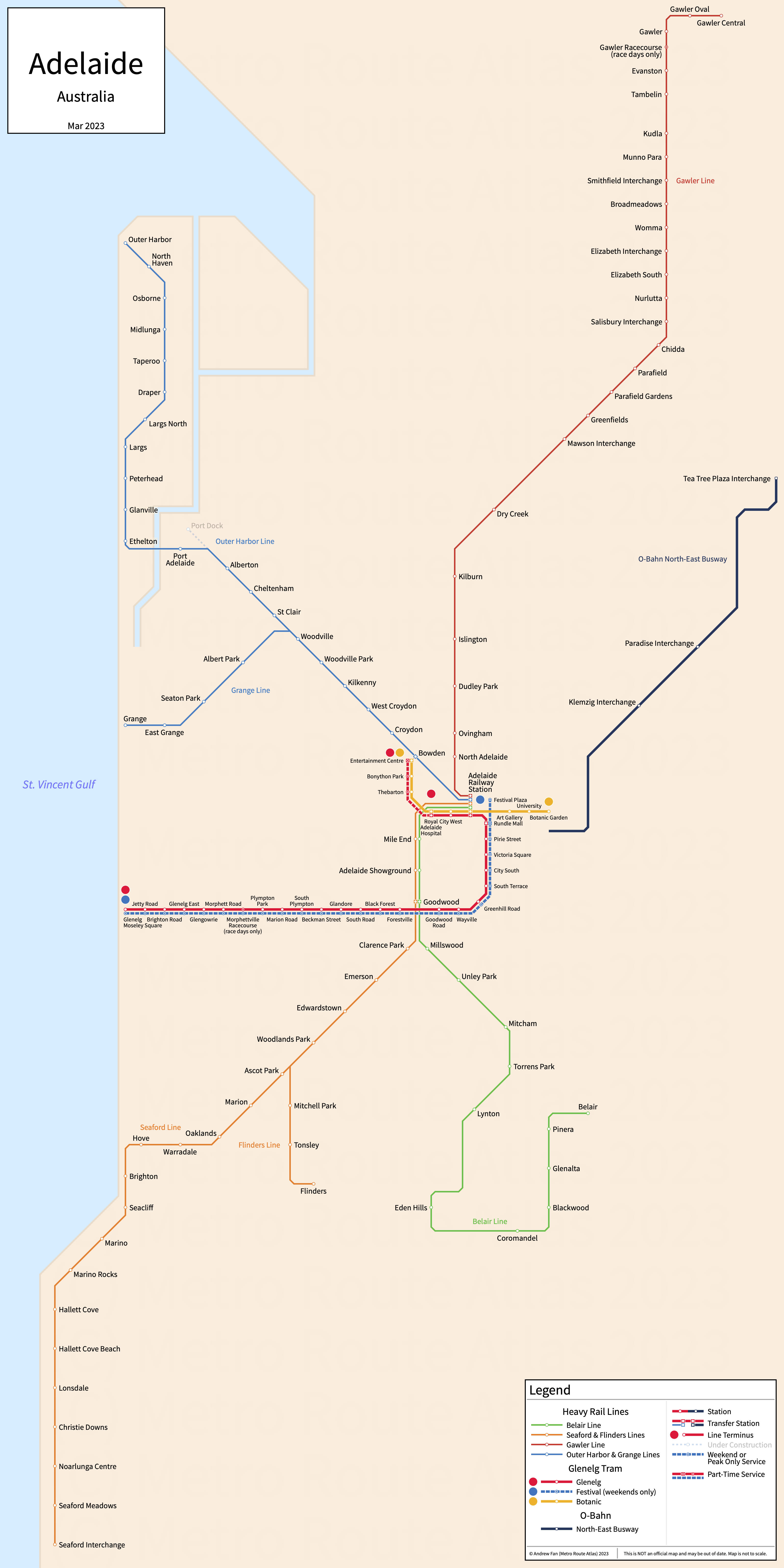
Table of Contents
Overview - Adelaide
Located on the St. Vincent Gulf, Adelaide is the capital of and the largest city by population in South Australia. It has approximately 1,368,209 inhabitants in the city proper as of 2021. The Adelaide metropolitan area (Adelaide GCCSA) comprised 1,387,290 residents as of the 2021 Australian Bureau of Statistics Estimate.
Adelaide's rapid transit network consists of two light rail services, a modern tramway service, and a bus rapid transit line. It also has seven regional rail/commuter rail lines.
Glenelg Tram
Opened 1873, the Glenelg Tram consists of two light rail services and a modern tramway service that serve the city of Adelaide, South Australia and the southwestern suburbs.
Glenelg Line
The Glenelg Line is a light rail service on a Northeast-Southwest alignment. It runs from Glenelg - Moseley Square in the southwest to Royal Adelaide Hospital and (rush hours only) Entertainment Centre in the northeast, serving 29 stations of which one is events only and three are rush hour only. During weekends, a supplementary service called the Festival Line serves Festival Plaza. Service currently suspended between Glenelg and South Terrace due to grade separation works until January 2026.
The Glenelg Line was opened in August 1873 and was converted to a tramway in December 1929. The last extension to the line was to the Entertainment Center in March 2010. Festival Plaza opened October 2018.
| Service | M-F Midday | M-F Rush | Sat. | Sun. | Notes |
|---|---|---|---|---|---|
| Glenelg | 10' | 5/10' | 10' | 10' | |
| Festival | No Service | No Service | 20' | 20' |
Schedules -- Last Updated: Sept 02, 2024
Botanic Line
The Botanic Line is a modern tramway service on an East-West alignment. It runs from Entertainment Centre in the west to the Botanic Gardens in the east, serving 9 stations.
The Botanic Line was opened in October 2018 as part of the City Tram extension.
| Service | M-F Midday | M-F Rush | Sat. | Sun. | Notes |
|---|---|---|---|---|---|
| Botanic | 10' | 10' | 10' | 10' |
Schedules -- Last Updated: Sept 02, 2024
Adelaide O-Bahn
Opened 1986, the Adelaide O-Bahn consists of a single bus rapid transit line that services the city of Adelaide, South Australia, and the northeastern suburbs.
North-East Busway
The North-East Busway is a physically guided bus rapid transit line on a northeast-southwest alignment. It runs from Tea Tree Plaza Interchange in the northeast into the city center in the southwest, serving 3 stations.
The North-East Busway was opened in March 1986 and the last extension was the City Access Tunnel in December 2017.
Adelaide Trains
Opened starting in 1856, the Adelaide Trains network consists of seven regional rail lines grouped into four trunk lines.
Belair Line
The Belair Line is a regional rail line on a U-shaped alignment. It runs from Adelaide Station in the northwest to Belair in the southeast, serving 15 stations.
The Belair Line was opened in 1883 to Bridgewater but was cut back to Belair in 1987.
Seaford & Flinders Line
The Seaford and Flinders Lines are regional rail lines on a Northeast-Southwest alignment. They run from Adelaide Station in the northeast to Seaford and Flinders in the southwest, serving 27 stations.
The Seaford Line was opened in 1913 and the last extension was to Seaford in February 2014 when the line was electrified. The Flinders Line opened 1966 as the Tonsley Line and the last extension was to Flinders in December 2020.
Gawler Line
The Gawler Line is a regional rail line on a northeast-southwest alignment. It runs from Gawler Central in the northeast to Adelaide Station in the southwest, serving 27 stations of which one is served on race days only.
The Gawler Line was opened in 1857 and the last extension was to Gawler Central in 1911.
Outer Harbor, Grange, and Port Dock Line
The Outer Harbor, Grange, and Port Dock Lines are regional rail lines on a Northwest-Southeast alignment. They run from Outer Harbor, Grange, and Port Dock in the northwest to Adelaide Station in the southeast, serving 27 stations.
The Outer Harbor Line was opened in 1856 and the last extension was to Outer Harbor in 1908. The Grange Line opened in 1882. The Port Dock Line was reopened in August 2024
References & Helpful Links
Railways in Adelaide at Wikipedia
Official Website for Glenelg Tram, O-Bahn, and Adelaide Trains: Adelaide Metro
Maps
All Official Maps - Adelaide Metro [Last Accessed September 02, 2024]
Official System Map - Adelaide Metro Rail Network [PDF] [Last Accessed September 02, 2024]
Other Sources
Adelaide, Australia at Urbanrail.net
Adelaide, Australia at BRTDATA.org
Other Websites
External Citations
Asset Notes
Train line colors taken from official Adelaide Metro Rail network map as of February 2023. Tram line colors taken from official tram map and timetable as of February 2023. O-Bahn color taken from Adelaide Metro logo on their website as of February 2023.