Santo Domingo, National District, Dominican Republic
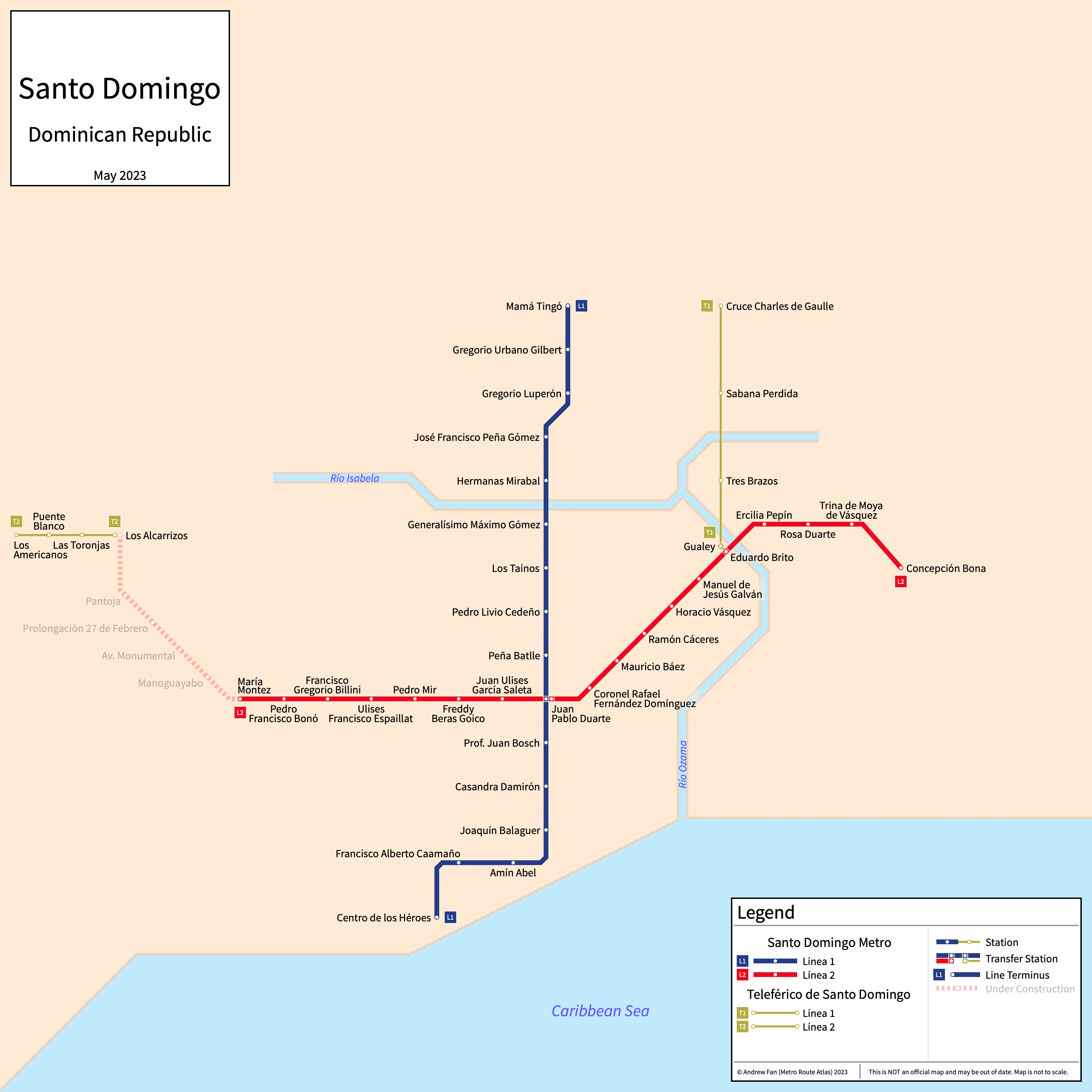
Table of Contents
Overview - Santo Domingo
Located on the Caribbean Sea, Santo Domingo (Santo Domingo de Guzmán) is the capital of and the largest city by population in the Dominican Republic. It has approximately 1,029,000 inhabitants in the city proper as of 2022. The Santo Domingo metropolitan area comprised 4,274,651 residents as of the 2023 ONE census.
Santo Domingo's rapid transit network consists of two metro services and two gondola lift services.
Santo Domingo Metro
Opened 2009, Santo Domingo Metro consists of two rapid transit services that serve the city of Santo Domingo, Dominican Republic and the surrounding suburbs. Most stations are named after historical and cultural figures rather than streets.
Line 1 (Línea 1)
Line 1 of the Santo Domingo Metro is a metro service on a North-South alignment. It runs from Centro de los Héroes in the south to Mamá Tingó in the north, serving 16 stations.
Line 1 was opened in January 2009. Line 1 is operated by OPRET.
Line 2 (Línea 2)
Line 2 of the Santo Domingo Metro is a metro service on an East-West alignment. It runs from Pablo Adón Guzmán in the west to Concepción Bona in the east, serving 22 stations.
Line 2 was opened in April 2013 and the last extension of the line was to Pablo Adón Guzmán in February 2026. Line 2 is operated by OPRET.
Teleférico de Santo Domingo
Opened 2018, the Teleférico de Santo Domingo consists of two gondola lift services that serve the city of Santo Domingo, Dominican Republic and the surrounding suburbs.
Line 1 (Línea 1)
Line 1 of the Teleférico de Santo Domingo is a gondola lift service on a North-South alignment. It runs from Gualey in the south to Cruce Charles de Gaulle in the north, serving 4 stations.
Line 1 was opened in May 2018. Line 1 is operated by OPRET.
Line 2 (Línea 2)
Line 2 of the Teleférico de Santo Domingo is a gondola lift service on an East-West alignment. It runs from Los Americanos in the west to Los Alcarrizos in the east, serving 4 stations.
Line 2 was opened in May 2023. Line 2 is operated by OPRET.
References & Helpful Links
Santo Domingo Metro at Wikipedia | Metro de Santo Domingo at Wikipedia.es
Teleférico de Santo Domingo at Wikipedia | Teleférico de Santo Domingo at Wikipedia.es
Official Website for Santo Domingo Metro and Teleférico: Oficina para el Reordenamiento de Transporte (OPRET)
Maps
All Official Maps - OPRET [Last Accessed Feb 25, 2026]
Official System Map - Santo Domingo Metro and Teleférico [JPG] [Last Accessed Jul 14, 2025]
Other Sources
Santo Domingo, Dominican Republic at Urbanrail.net
External Citations
Asset Notes
All colors taken from official system map as of March 20, 2021.