Newark-Jersey City, New Jersey, USA
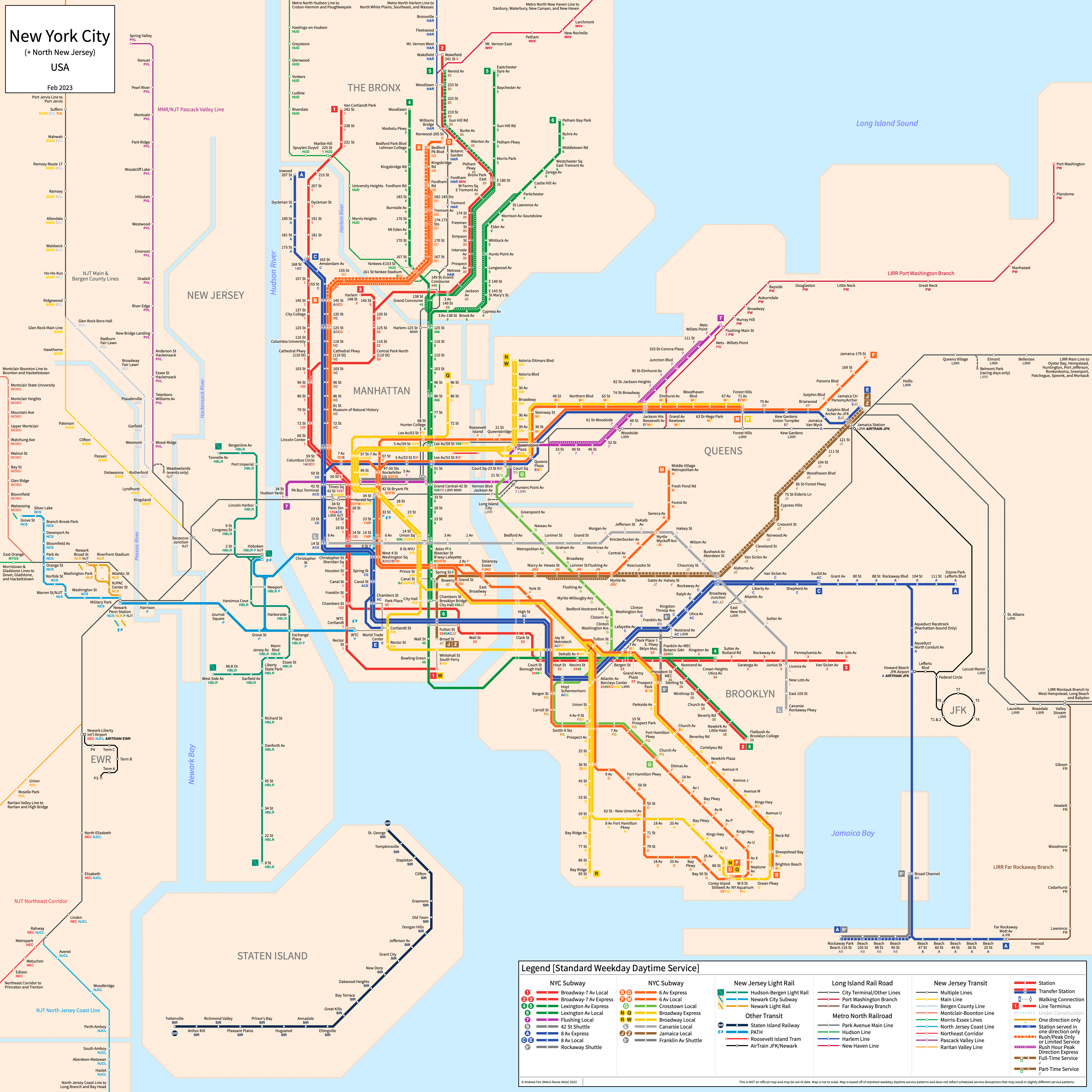
Table of Contents
Overview - Newark-Jersey City, New Jersey
Located on the Passaic River, Newark is the seat of Essex County and the largest city by population in New Jersey. It has approximately 305,000 inhabitants in the city proper as of 2023. On the Hudson River to the east, Jersey City is the seat of Hudson County and is the second largest city by population in New Jersey with approximately 292,000 inhabitants in the city proper as of 2023. They, along with other cities in North New Jersey, are part of the New York City Metropolitan Area
North New Jersey's rapid transit network consists of a metro network connecting it to New York City as well as two light rail services and a modern tram service. It also has a commuter rail network that connects it to New York City.
Port Authority Trans-Hudson (PATH)
Opened 1908 and branded as PATH in 1962, the Port Authority Trans-Hudson (PATH) is a metro network serving Manhattan and North New Jersey, connecting Midtown Manhattan and Lower Manhattan with Hoboken, Jersey City, and Newark.
Future expansion plans as of July 2019 for the PATH network focus on an extension past Newark Penn Station to Newark Airport.
PATH
The PATH is a metro network with 13 stations. It runs underground except on the branch to Newark. It features two main tunnels into Manhattan, with one going to the World Trade Center in Lower Manhattan and one going to Midtown Manhattan via 6 Av. Service patterns vary depending on the time of day but during weekdays during the day, four services operate - Newark Penn Station to WTC, Journal Square to 33 St, Hoboken to 33 St, and Hoboken to WTC. During Weekends, the latter three services are combined into a single service running from 33 St to Journal Square via Hoboken, with the Newark Penn Station to WTC route remaining as well.
The PATH gained its brand in 1962 and has not seen significant expansion since its creation outside of the rebuilding of the World Trade Center complex following the 9/11 attacks in Lower Manhattan.
| Service | M-F Midday | M-F Rush | Sat. | Sun. | Notes |
|---|---|---|---|---|---|
| Hoboken-33 St | 15' | 8' | 20' | 20' | Blue on maps; *1 |
| Journal Square-33 St | 12' | 4' | 20' | 20' | Orange on maps; *1 |
| Hoboken-World Trade Center | 15' | 8' | No Service | No Service | Green on maps |
| Newark-World Trade Center | 20' | 5' | 20' | 20' | Red on maps |
Schedules -- Last Updated: Dec 08, 2025
*1 - Operate as one branded service on Weekends
Newark Light Rail
Opened 1935, the Newark Light Rail consists of a light rail service and modern tram service that serve the city of Newark, New Jersey.
Newark City Subway
The Newark City Subway is a light rail service with 12 stations on a North-South alignment, running from Grove Street in the north to Newark Penn Station in the south. It runs underground in downtown Newark.
The Newark City Subway was opened in May 1935 and the last expansion to the line was in June 2002 to Grove Street in Bloomfield. The Newark City Subway is owned and operated by New Jersey Transit.
| Service | M-F Midday | M-F Rush | Sat. | Sun. | Notes |
|---|---|---|---|---|---|
| Grove Street (NCS) | 10' | 3-5' | 20' | 25' | *1 |
Schedules -- Last Updated: Mar 29, 2025
*1 - Rush hours, only every other train continues beyond Branch Brook Park
Newark Light Rail
The Newark Light Rail is a modern tram service with 6 stations on a North-South alignment, running from Broad Street Station in the north to Newark Penn Station in the south.
The Newark Light Rail was opened in 2006. The Newark Light Rail is owned and operated by New Jersey Transit.
| Service | M-F Midday | M-F Rush | Sat. | Sun. | Notes |
|---|---|---|---|---|---|
| Broad Street (NLR) | 30' | 10' | 20' | 25' |
Schedules -- Last Updated: Mar 29, 2025
Hudson-Bergen Light Rail
Opened 2000, the Hudson-Bergen Light Rail consists of a light rail network that serves the cities along the west bank of the Hudson River.
Current expansion plans as of July 2019 include an extension past West Side Avenue to the Hackensack River waterfront, as well as an extension north into Bergen County.
Hudson-Bergen Light Rail
The Hudson-Bergen Light Rail is a light rail network with 24 stations on a North-South alignment, running from Tonnelle Avenue in the north to West Side Avenue and 8th Street in the south with an additional terminus at Hoboken station. It is served by three services - Hoboken-Tonnelle (green, weekdays only), Hoboken-8th St (blue), and West Side Av-Tonnelle (orange).
The Hudson-Bergen Light Rail was opened in April 2000 and the last expansion to the line was in January 2011 to 8th Street. The Hudson-Bergen Light Rail is owned by New Jersey Transit.
| Service | M-F Midday | M-F Rush | Sat. | Sun. | Notes |
|---|---|---|---|---|---|
| West Side Ave - Tonnelle Ave (Yellow) | 20' | 10-12' | 20' | 20' | *1 |
| 8th St - Hoboken (Blue) | 20' | 6-12' | 20' | 20' | *1 |
| Tonnelle Ave - Hoboken (Green) | 20' | 15' | No Service | No Service |
Schedules -- Last Updated: Mar 29, 2025
*1 - No scheduled headway around rush hour. Numbers provided are very rough estimates
New Jersey Transit
New Jersey Transit Rail Operations, starting operation in 1983, operates commuter railways in New Jersey and New York. It consists of two divisions - Newark (Northeast Corridor and Princeton Branch, North Jersey coast Line, Raritan Valley Line, and Atlantic City Line) and Hoboken (Main Line, Bergen County Line, Pascack Valley Line, Port Jervis Line, Meadowlands Rail Line, Montclair-Boonton Line, Morristown Line, and Gladstone Branch).
The Atlantic City Line is under the Philadelphia page. The Port Jervis Line is under Metro North.
Main & Bergen County Lines
The Erie Main Line is a commuter rail service on a primarily North-South alignment, running from Hoboken Terminal in New York City to Suffern, New York and serving 17 stations. It shares much of its alignment with the Bergen County Line, a commuter rail line also on a primarily North-South alignment, running from Hoboken Terminal to Suffern, New York and serving 17 stations. Some services continue to Port Jervis on the Port Jervis Line.
The last expansion to the Main Line and the Bergen County Line was the opening of the Ramsey Route 17 station in August 2004.
Montclair-Boonton Line
The Montclair-Boonton Line is a commuter rail service on a primarily East-West alignment, running from Hoboken Terminal and New York Penn Station to Bay Street, Montclair State University, and Hackettstown and serving 27-28 stations depending on the eastern terminal. Service is limited west of Montclair State University, as that is where electrification stops. Service west of Dover is not shown on the strip map above. Weekend service terminates at Bay Street.
The last expansion to the Montclair-Boonton Line was the opening of the Wayne Route 23 station in March 2008.
Morris-Essex Lines
The Morristown Line is a commuter rail service on a primarily East-West alignment, running from Hoboken Terminal and New York Penn Station to Dover and Hackettstown and serving 26 stations. Service is limited west of Dover, as that is where electrification stops, and is not shown on the strip map above. The Gladstone Branch is a commuter rail line on a primarily East-West alignment sharing stations with the Morristown Line from New York Penn Station and Hoboken to Summit. Beyond Summit it runs to Gladstone, serving 24 stations in total. It operates as a shuttle between Gladstone and Summit on weekends, requiring a transfer to a Morristown Line service for service to the eastern terminals.
The last expansion to the Morristown Line was the opening of the Mount Arlington station in January 2008. The last expansion to the Gladstone Branch itself was the opening of Summit station in 1905.
North Jersey Coast Line
The North Jersey Coast Line is a commuter rail service on a primarily North-South alignment, running from Bay Head and Long Branch in the south to Rahway in the north, at which point trains use the Northeast Corridor to Penn Station. The line serves 20 stations south of Rahway. Service is limited south of Long Branch, as that is where electrification stops, and is not shown on the strip map above.
The last expansion to the North Jersey Coast Line was the opening of Secaucus Junction in 2003.
Northeast Corridor Line
The Northeast Corridor Line is a commuter rail service on a primarily North-South alignment, running from New York Penn Station in the north to Trenton in the south, with a shuttle to Princeton. The line serves 17 stations. Note that about half of all services from New York terminate at Jersey Avenue.
The last expansion to the Northeast Corridor Line was the opening of Secaucus Junction in 2003.
Pascack Valley Line
The Pascack Valley Line is a commuter rail service on a primarily North-South alignment, running from Hoboken Terminal in the south to Spring Valley, New York in the north, serving 18 stations.
The last expansion to the Pascack Valley Line was the opening of Secaucus Junction in 2003.
Raritan Valley Line
The Raritan Valley Line is a commuter rail service on a primarily East-West alignment, running from Raritan and High Bridge in the west to Newark Penn Station in the east, serving 20 stations. Only service to Raritan is shown on the strip map above due to limited service west of Raritan.
The last expansion to the Raritan Valley Line was the opening of Secaucus Junction in 2003.
Metro-North Railroad
Opened in its current form in 1983, Metro-North Railroad is a commuter and regional railway connecting New York City with its northern suburbs, including Rockland, Westchester, Putnam and Dutchess counties in New York and Fairfield and New Haven counties in Connecticut. It consists of three main lines on the east side of the Hudson River that terminate at Grand Central Terminal in New York City, as well as two lines extending out of northern New Jersey, with these trains terminating in Hoboken, New Jersey. All services east of the Hudson River are operated by the Metropolitan Transit Authority of New York, while Pascack Valley and Port Jervis Line services are operated by New Jersey Transit.
For more information on Metro North and for strip maps of the lines east of the Hudson River, refer to the New York City page. The Pascack Valley Line is located under New Jersey Transit.
Port Jervis Line
The Port Jervis Line is a commuter rail line on a primarily East-West alignment, running from Port Jervis in the west to Suffern, New York in the east with services continuing to Newark Penn Station via the NJ Transit Main and Bergen County Lines, serving 25-26 stations in total (though services typically skip stops between Secaucus and Ramsey Route 17).
The last expansion to the Port Jervis Line was the opening of Ramsey Route 17 in August 2004.
References & Helpful Links
Port Authority Trans-Hudson at Wikipedia
Newark Light Rail at Wikipedia
Hudson-Bergen Light Rail at Wikipedia
New Jersey Transit at Wikipedia
Metro-North Railroad at Wikipedia
Official Website for Port Authority Trans-Hudson: Port Authority Trans-Hudson
Official Website for Newark and Hudson-Bergen Light Rail: New Jersey Transit
Official Website for New Jersey Transit Commuter Rail: New Jersey Transit
Official Website for Metro-North Railroad: Metropolitan Transit Authority
Maps
All Official Maps - MTA [Last Accessed December 08, 2025]
All Official Maps - New Jersey Transit [Last Accessed December 08, 2025]
Official System Map - Port Authority Trans-Hudson [Last Accessed December 08, 2025]
Official System Map - Hudson-Bergen Light Rail [PDF] [Last Accessed December 08, 2025]
Official System Map - Newark Light Rail [PDF] [Last Accessed December 08, 2025]
Official System Map - New Jersey Transit Commuter Rail [PDF] [Last Accessed December 08, 2025]
Official System Map - Long Island Rail Road & Metro-North Railroad [Last Accessed December 08, 2025]
Unofficial Map - New York & New Jersey Subway [2016] by Stewart Mader (www.stewartmader.com)
Other Sources
North New Jersey, USA at Urbanrail.net
Asset Notes
Route icon for the PATH taken from the official logo as of May 2019 via Wikimedia.
Route colors for Metro North are the official route colors in use as of May 2019 as stated on MTA Line Colors.
Metro North text color taken from official MTA logo.
New Jersey Transit rail line colors taken from June 2019 official NJT Rail map. New Jersey Transit text color taken from official NJ Transit logo.
Hudson-Bergen Light Rail and Newark Light Rail line colors taken from June 2019 official Hudson-Bergen Light Rail and Newark Light Rail maps.