Miami, Florida, USA
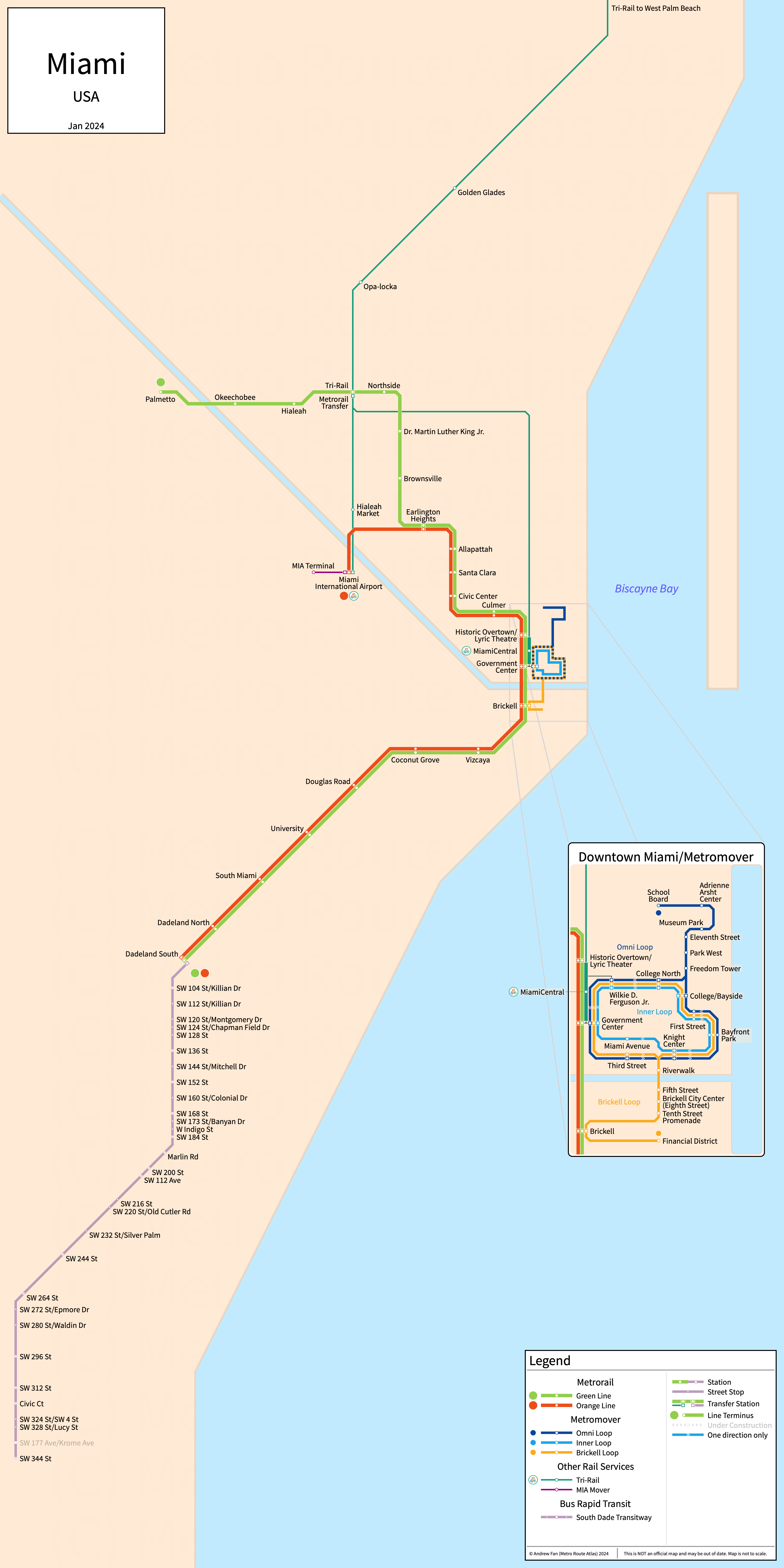
Table of Contents
Overview - Miami
Located on the Atlantic Ocean, Miami is the seat of Miami-Dade County and the second most populated city in Florida by population behind Jacksonville. It has approximately 456,000 inhabitants in the city proper as of 2023. The Miami metropolitan area (Miami-Fort Lauderdale-West Palm Beach) comprised 6,183,199 residents as of the 2023 US Census Bureau Estimate.
Miami's rapid transit network consists of two metro services and a people mover with three services. It also has a commuter rail service to cities to the north and a bus rapid transit line connecting the far south of the city to the southern suburbs.
Miami Metrorail
Opened 1984, the Miami Metrorail consists of two rapid transit services mainly using shared track, connecting the city of Miami, Florida to Miami International Airport and Hialeah in the north, and Dadeland in the south.
Metrorail
Miami's Metrorail is a metro system on a primarily North-South alignment, running from Palmetto and Miami International Airport in the north to Dadeland South via the city center of Miami and serving 23 stations.
Miami Metrorail was opened in May 1984 and the last expansion to the line was the extension to Miami International Airport in 2012, which formed the Orange Line. Miami Metrorail is operated by Miami-Dade Transit.
| Service | M-F Midday | M-F Rush | Sat. | Sun. | Notes |
|---|---|---|---|---|---|
| Green | 15' | 10' | 15-20' | 15-20' | |
| Orange | 15' | 10' | 15' | 15' | *1 |
Schedules -- Last Updated: Mar 23, 2025
*1 - Operates as a shuttle between Earlington Heights and the airport on weekends
Metromover
Opened 1986, the Miami Metromover consists of three people mover services serving the downtown core of the city.
Metromover
Miami's Metromover is a people mover system on a primarily North-South alignment with a loop around downtown Miami. The alignment can be broken down into three sections - the central loop shared by all three services, the Omni Loop terminating at the School Board in the north, and the Brickell Loop terminating at the Financial District in the south. There are a total of 21 stations spaced about 2-3 blocks apart. The Inner Loop runs clockwise around the main loop, while the Brickell and Omni loops run counterclockwise.
Miami's Metromover (inner loop) was opened in April 1986 and the last expansions to the network were the counterclockwise loops as well as the corresponding extensions north to Brickell and the Financial District (Brickell Loop) and the School Board (Omni Loop) in 1994. Miami's Metromover is operated by Miami-Dade Transit.
Tri-Rail
Opened 1989, Tri-Rail is a commuter rail service connecting Miami, Ft. Lauderdale, and West Palm Beach. It serves Miami-Dade, Broward, and Palm Beach counties, hence its name "Tri-Rail" for the three counties.
Tri-Rail
Tri-Rail is a commuter rail service running on a primarily at-grade North-South alignment along CSX's former Miami Subdivision. It serves 19 stations, running from Mangonia Park in the North to Miami Airport and Brightline's MiamiCentral terminus in the south.
Tri-Rail was opened in January 1989 and was last extended in January 2024 with the opening of the new MiamiCentral station. It is owned by the South Florida Regional Transportation Authority.
South Dade Transitway
South Dade Transitway
The South Dade Transitway is a bus rapid transit open busway on a north-south alignment. It serves 30 stops, running from SW 344 St in the south to Dadeland South in the north. The primary service is the 38.
The South Dade Transitway was opened as the South Dade Busway in February 1997, and the last extension was to SW 344 St in December 2007.
References & Helpful Links
Official Website for Miami Metrorail: Miami-Dade County
Official Website for Miami Metromover: Miami-Dade County
Official Website for Tri-Rail: Tri-Rail
Maps
Official System Map - Miami Metrorail [PDF] [Last Accessed Mar 23, 2025]
Official System Map - Miami Metromover [PDF] [Last Accessed Mar 23, 2025]
Unofficial Map - Metrorail & Metromover [Oct 2016] by Peter Dovak (transitmap.net)
Other Sources
Asset Notes
Metrorail and Tri-Rail line colors taken from November 2018 official Metrorail map. South Dade Transitway color taken from November 2023 official Metrorail map.
Metromover service colors taken from August 2018 official Metromover map.
Tri-Rail icon taken from Wikimedia and center icon isolated by removing the text and shifting the main icon left by 62 pixels. This icon is in the public domain.