Brisbane, Queensland, Australia
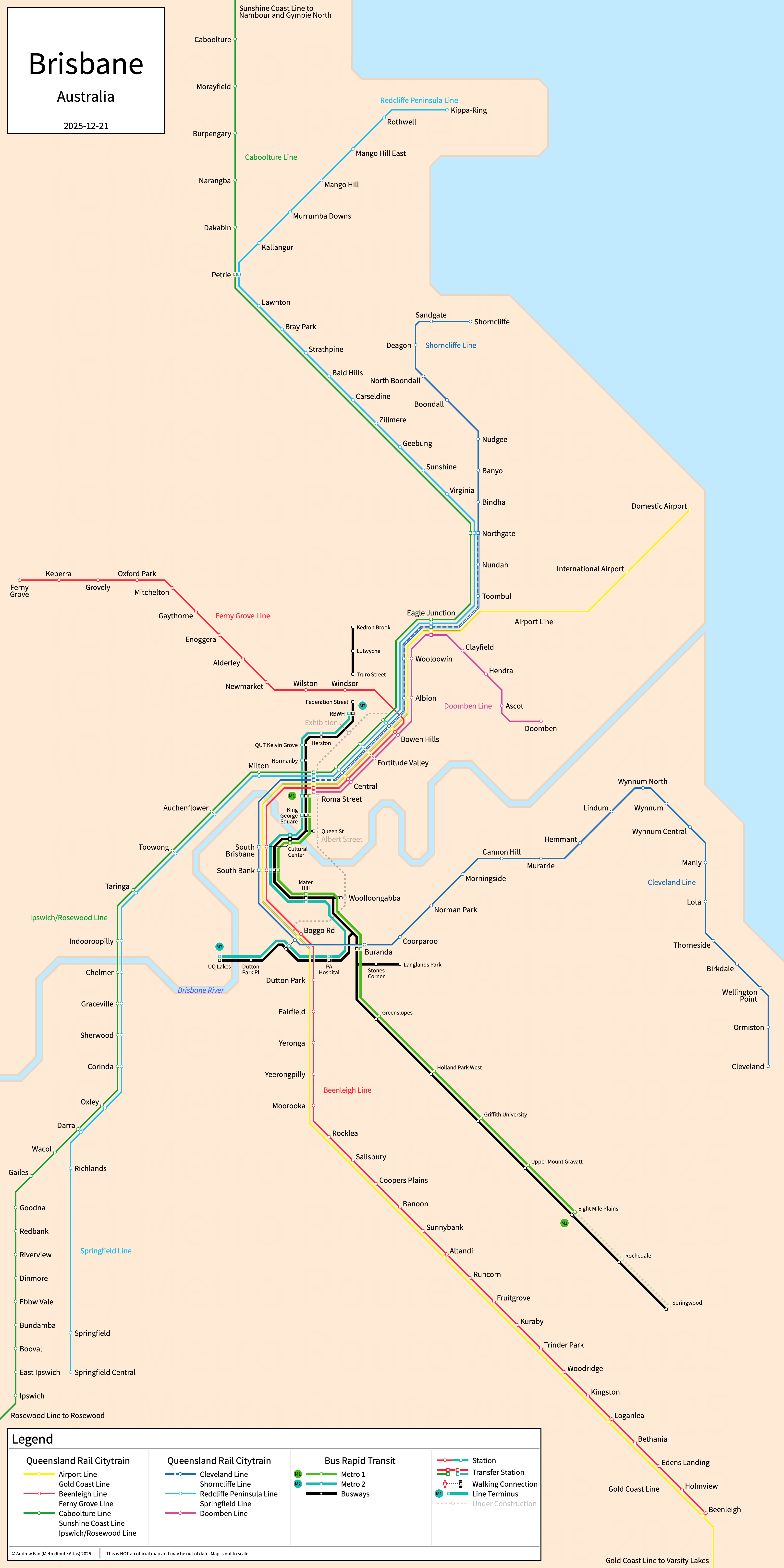
Table of Contents
Overview - Brisbane
Located on the Brisbane River, Brisbane is the capital of Queensland and the largest city by population in Australia. It has approximately 2,447,000 inhabitants in the city proper as of 2021. The Brisbane metropolitan area (Brisbane GCCSA) comprised 2,526,238 residents as of the 2021 Australian Bureau of Statistics Estimate.
Brisbane's rapid transit network consists of two bus rapid transit services running on three bus rapid transit open busways and an urban mainline rail line. It also has a regional and commuter rail network.
Brisbane Metro and Busways
Opened April 2001, Brisbane's Busway network consists of three bus rapid transit open busways that serve the city of Brisbane, Queensland and the surrounding suburbs. In 2025, the Brisbane Metro began service, providing rebranded trunk services across the inner busways.
Metro M1
Line M1 of the Brisbane Metro is a bus rapid transit service on a North-South alignment. It runs from Roma Street in the north to Eight Mile Plains in the south along the South East Busway, serving 11 stations.
Line M1 was opened in June 2025. Line M1 is owned by the Brisbane City Council and operated by Transport for Brisbane.
Metro M1
Line M2 of the Brisbane Metro is a bus rapid transit service on a North-South alignment. It runs from RBWH in the north to UQ Lakes in the south along the South East Busway and Eastern Busway, serving 12 stations. It does NOT serve all busway stops, skipping Dutton Park Pl.
Line M2 was opened in January 2025. Line M2 is owned by the Brisbane City Council and operated by Transport for Brisbane.
South East Busway
The South East Busway is a bus rapid transit open busway on a North-South alignment. It runs from King George Square and Queen Street in the north to Springwood in the south, serving 14 stations.
The South East Busway was opened in September 2000 and the last extension was to Springwood in May 2025.
Northern Busway
The Northern Busway is a bus rapid transit open busway on a North-South alignment. It runs from King George Square in the south to Kedron Brook in the north, serving 10 stations. Between Federation St and Truro St, buses operate in mixed traffic, and so the portion closer to the city is often referred to as the Inner Northern Busway.
The Northern Busway was opened in February 2004 and the last extension was to Kedron Brook in June 2012.
Eastern Busway
The Eastern Busway is a bus rapid transit open busway on an East-West alignment. It runs from UQ Lakes in the west to Langlands Park in the east, serving 7 stations.
The Eastern Busway was opened in August 2009 and the last extension was to Langlands Park in August 2011.
Queensland Rail Citytrain
Queensland Rail's Citytrain network, operated by Translink, consists of 12 railway lines of which most operate as Regional Rail. All lines run through a central trunk segment where the combined service operates as an S-Train. An additional cross-city line is under construction.
Citytrain Core
The core of the Brisbane rail network is a S-Train line on a Northeast-Southwest alignment. All services run through this segment.
Airport Line
The Airport Line is a regional rail line on a Northeast-Southwest alignment. It branches off at Eagle Junction and runs to Domestic Airport in the northeast, serving 5 stations outside the core. Every other weekday service through-operates onto the Gold Coast Line.
The Airport Line was opened in May 2001.
Beenleigh Line
The Beenleigh Line is a regional rail line on a North-South alignment. It branches off at Boggo Rd and runs to Beenleigh in the south, serving 25 stations outside the core. Trains through-operate onto the Ferny Grove Line.
The Beenleigh Line was opened in April 1885 as the Logan Line and the last extension was to Beenleigh in July 1885.
Caboolture Line
The Caboolture Line is a regional rail line on a North-South alignment. It runs along the North Coast Line from Roma Street in the south to Caboolture in the north, serving 8 stations outside the core. Trains through-operate onto the Ipswich/Rosewood Line.
The Caboolture Line was opened in June 1888 and the last extension was to Caboolture in June 1889.
Cleveland Line
The Cleveland Line is a regional rail line on a Northwest-Southeast alignment. It branches off at Boggo Rd and runs to Caboolture in the southeast, serving 21 stations outside the core. Trains through-operate onto the Shorncliffe Line.
The Cleveland Line was opened in 1888 and the last extension was to the current Cleveland station in 1987.
Doomben Line
The Doomben Line is a commuter rail line on an east-west alignment. It branches off at Eagle Junction and runs to Doomben in the east, serving 7 stations outside the core. The line is predominantly single track.
The Doomben Line was opened in September 1882 and was cut back from Eagle Farm in September 1993.
Ferny Grove Line
The Ferny Grove Line is a regional rail line on a northwest-southeast alignment. It branches off at Bowen Hills and runs to Ferny Grove in the northwest, serving 11 stations outside the core. Trains through-operate onto the Beenleigh Line.
The Ferny Grove Line was opened in 1899 and was cut back to Ferny Grove in 1955.
Gold Coast Line
The Gold Coast Line is a regional rail line on a north-south alignment. It runs from Bowen Hills in the north to Varsity Lakes in the south, serving 13 stations outside the core. Trains through-operate onto the Airport Line.
The Gold Coast Line was opened in 1996 and the last expansion was the opening of Pimpama in October 2025.
Ipswich/Rosewood Line
The Ipswich/Rosewood Line is a regional and commuter rail line on a northeast-southwest alignment. It runs along the Main Line from Bowen Hills in the northeast to Ipswich and Rosewood in the southwest, serving 28 stations outside the core. Trains through-operate onto the Caboolture and Sunshine Coast Lines. The section from Rosewood to Ipswich is usually operated as a shuttle.
The Ipswich/Rosewood Line was opened in 1876 to Ipswich.
Redcliffe Peninsula Line
The Redcliffe Peninsula Line is a regional rail line on a northeast-southwest alignment. It branches off at Petrie, serving 18 stations outside the core. Trains through-operate onto the Springfield Line.
The Redcliffe Peninsula Line was opened in October 2016.
Shorncliffe Line
The Shorncliffe Line is a S-Train and regional rail line on a northeast-southwest alignment. It branches off at Northgate, serving 14 stations outside the core. Trains through-operate onto the Cleveland Line. Additional short turn trains run between Northgate and Roma Street.
The Shorncliffe Line was opened in 1882.
Springfield Line
The Springfield Line is a regional rail line on a northeast-southwest alignment. It branches off at Darra, serving 14 stations outside the core. Trains through-operate onto the Redcliffe Peninsula Line.
The Springfield Line was opened in December 2013.
Sunshine Coast Line
The Sunshine Coast Line is a commuter rail line on a North-South alignment. It runs along the North Coast Line from Roma Street in the south to Gympie North in the north, serving 17 additional stations past Caboolture. Trains through-operate onto the Caboolture Line. Most services terminate at Nambour.
The Sunshine Coast Line was opened in 1890 and the last expansion was the opening of Elimbah and Beerburrum in April 2009.
References & Helpful Links
Busways in Brisbane at Wikipedia
Railways in South East Queensland at Wikipedia
Official Website for Brisbane Metro: Brisbane Metro
Official Website for Queensland Rail Citytrain: Translink
Maps
All Official Maps - Translink [Last Accessed December 12, 2025]
Official System Map - Translink [PDF] [Last Accessed December 12, 2025]
Official System Map - Brisbane Metro [PDF] [Last Accessed December 13, 2025]
Other Sources
Brisbane, Australia at Urbanrail.net
Brisbane, Australia at BRTDATA.org
Other Websites
External Citations
Asset Notes
All lines and colors for SEQ Railway network and Metro services were taken from the official Translink network map as of December 13, 2025.