Niamey, Niger
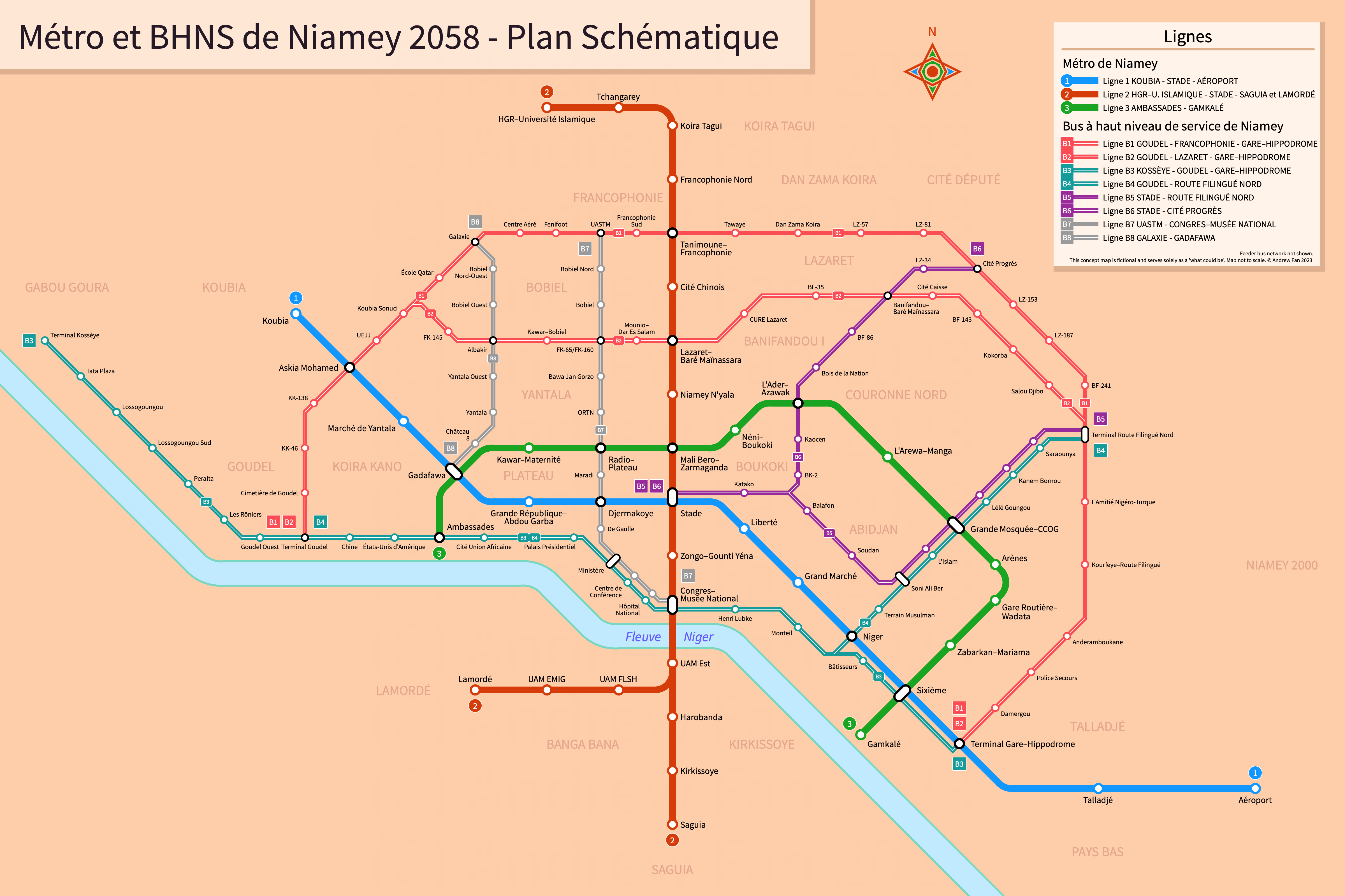
Table of Contents
Overview - Niamey
Split in two by the Niger River, Niamey is the capital of and the largest city by population in Niger. It has approximately 1,324,700 inhabitants in the city proper as of 2020 and is, as of the time of writing, rapidly growing.
Challenge Rules
No specific limitations or guidelines were set forth for this competition. Competition period was September 27, 2023 through October 22, 2023 on the Global Transit and Infrastructure Central (GTIC) Discord.
Geography and Corridors
Niamey is defined by the Niger river, which cuts through it northwest to southeast. While the majority of the city is on the northeast side, the southwest side hosts the Université Abdou Moumouni de Niamey (UAM), as well as some residential districts.
The east bank is defined by several major road corridors, with RN1 running northwest-southeast, Boulevard Mali Bero almost forming a semicircle around the core of the city, and another ring road further beyond generally separating the core of the city from informal settlements. The major north-south road is RN24, and the Boulevard de la République and Ave de l'Africa mostly hug the eastern bank of the river. On the west bank, RN6 and RN27 are the main roads. There is a railway station in the southeast of the city.
Outside of the core city, major destinations include UAM on the west bank, the Diori Hamani International Airport in the far southeast, the Hôpital Général de Réference and Islamic University's Girls Campus (Campus des Filles des l'Université Islamique) in the far northwest, and the Great Mosque (Grande Mosquée) in the east.
Network Design - Thought Process
My philosophy with this map is fairly simple - serve as many people and destinations as possible with a reasonable approach, assuming the current layout of the city. While Niamey is no Kinshasa, it is still growing at a rapid rate and in typical fashion, informal settlements are sprawling outwards. It is imperative that a balanced approach be taken to move as many people as possible off of the congested roads. At the same time, Niamey has minimal existing mass transit infrastructure.
We will therefore propose a network of metro and bus rapid transit, with the metro acting as the backbone of the network and bus rapid transit covering corridors with less important destinations. Please note that we will attempt to follow existing rights of way as much as possible, and the assumption is being made that all construction is elevated (for metro) and at-grade (for bus rapid transit) unless stated otherwise.
Métro de Niamey
Niamey's road network and general layout provide a fairly standard set of corridors for use. First and foremost, the RN1 routing is a no-brainer. Cutting through the heart of the city, it serves the airport, intercity rail station, grand market, and stadium, as well as dense, close-in neighborhoods. It also runs within walking distance of the downtown core and the higher-end part of town without running through it (I do understand that throwing an elevated railway next to the US Embassy and Presidential Palace on the Boulevard de la République is not going to fly!). In the southeast, the anchor is the airport, while in the northwest, there is no clear anchor as outside of the ring road, the city becomes primarily informal residences. I think ending in Koubia at the creek is a fine option, and there is space for a small depot (though the main yard and OMF for the network should be near the airport where there is plenty of empty space). From end to end, this line is 16 km in length. Do note that this parallels the railway between the train station and airport, but given how the train station is in the middle of nowhere, replacing it with elevated metro and having the intercity line end at the airport is probably an upgrade.
To accompany this east-west corridor, the next logical step is to implement a north-south trunk line. On the east bank, the RN24 corridor is the logical choice, but it does not continue through the city center. In addition, on the west bank, the UAM area is mostly separated physically from the population centers. The good part is that the Gounti Yéna waterway bridges the gap between the RN24 and city core, and a parallel bridge to the Pont Kennedy would add significant capacity. For this reason, our second metro line will make use of these elements. On the west bank, the Route Principale UAM and Route de Say - RN6/Bd. de l'Université will be utilized, and we will use a branching approach with two branches joining before the river crossing. The university branch will begin at the end of the Route Principale UAM at Lamordé, and will be approximately 2.2 km. The other branch can start at the main junction in Saguia, where there is open space for a depot and bus terminal for trips originating further south. To the junction with the university branch, this is 3.7 km. Unfortunately, the remainder of the west bank of the Niger River is mostly informal settlements that do not extend far enough to justify any further rail rapid transit investment given the current extent of urbanization. From the junction of the branches, our line will cross the river parallel to the Pont Kennedy, turn onto Rue François Mitterand, and then follow the waterway to a shared area with Line 1 where there can be a cross platform interchange. From here, the route will turn north along RN24. As for where it will terminate, the biggest anchor in the north of the city is the Hôpital Général de Réference and Islamic University's Girls Campus (Campus des Filles des l'Université Islamique) complex. We will extend the line straight up and then follow the eastern and northern sides of the military base to reach this. The total length of the trunk line is 12.7 km, resulting in the line totaling 18.6 km.
Our final metro line will travel along the Bd. Mali Bero, which, although not directly cutting through the busiest parts of city, nevertheless serves numerous important destinations, including the Great Mosque. While it may not be the highest performing metro corridor at present, should the city center grow upwards, the area encircled by this boulevard will be the portion that grows the fastest, and will eventually need some form of higher-order mass transit. Our proposal has the line starting at the intersection of the Bd. des Ambassades and Av. de la Jeunesse, continuing north along Av. de la Jeunesse and Bd. Mali Bero before using Av. de l'Entent to close the open loop, ending at Av. de l'Africa. While it is possible to continue along Bd. Mali Bero instead of turning, the line would soon run into the Green Belt, and a transfer at Talladjé is less useful. The Tanimoune corridor runs into a similar issue with the Green Belt eating into the line's catchment area. Finally, the current alignment allows for the route to cross the river with ease if an extension is warranted in the future. The total length is 12.1 km.
Our total network comes out to 46.7 km, with a fairly comprehensive network.
BHNS de Niamey
For bus rapid transit, one of the core requirements is that the roadway is wide enough to fit dedicated median lanes or a busway. This restricts the number of viable corridors significantly as in mixed traffic conditions, it can be expected that buses will perform poorly. For this project, we will assume that we are using a fully segregated, high floor BRT system with median island platforms and terminal stations at the end of routes.
Niamey's core street grid does not lend itself to continuous routes. However, the outer ring road is an exception. From Goudel in the west to the Hippodrome and intercity rail station in the southeast, it is an unbroken road wide enough for a median busway. In addition, the only unbroken east-west corridor north of Bd. Mali Bero, comprising Rue FK-160, Bd. Ibraim Baré Maïnasarra, Rue LZ-2, and Rue BF-170, connects to the ring road on both ends. Our recommendation is thus to host two routes, one of which runs along the ring road in its entirety and one of which will follow the inner route. The ring road is around 18.8 km long and the inner route on its own is an additional 8.5 km long.
Next, the waterfront roadway is wide enough for bus rapid transit. In the west, anything past Kossèye is not particularly dense, but going east, it's a straight shot to the Pont Kennedy, after which RN6 and RN25 can be followed to meet up with the ring road routes. Extension further east is not recommended as there are no corridors with good continuous habitation - minibuses feeding into metro and ring road busway stations will be more efficient. The waterfront corridor is approximately 13.5 km.
Regarding radial links other than the waterfront, there are two that make sense east of Metro Line 2. The first is the corridor comprising Av. de L'Ader, Av. de Azawak, and Rue BF-77, which, if combined with Av. Soni Ali Ber, connects from the ring road to the stadium, the central hub for our metro network. The second is the corridor comprising Av. du Niger, Av. de L'Islam, and Av. des Aménokal, which can either use the same road to feed into the stadium, or continue to the Metro Line 1 corridor and potentially snake its way to Terminus and the waterfront busway corridor. Unfortunately, it's not a direct shot to Terminus, as connecting Rue du Maroc to the Avenue du Niger without dealing with the messy existing junctions would require a flyover that bulldozes several homes, as well as a widening of Rue du Maroc. Still, this would be worth it to connect directly to the city center. Also connecting down Av. Soni Ali Ber would provide additional connectivity however, so should not be ignored. In total, this is 4.4 km on the western corridor from the ring road to Av. Soni Ali Ber, 2.8 km on the eastern corridor from the ring road to Av. Soni Ali Ber, 2.4 km from the stadium to the junction of the eastern corridor with Av. Soni Ali Ber, and 1.8 km from the junction of the eastern corridor with Av. Soni Ali Ber to the waterfront corridor.
West of Metro Line 2, there are no corridors that continue south past Bd. Mali Bero. However, there are still two corridors that provide connections between the ring road and Bd. Mali Bero. The more eastern of the two is the corridor comprising Av. de la Radio, Rue FK-65, and a dirt road without a name on Open Street Maps as of the time of writing (3.5 km). For the aim of regional connectivity, we will also use Av. de Djermakoye and Av. de la Présidence to bring it down to connect to Metro Line 1 and the waterfront corridor (2.3 km). The more western of the two is the corridor comprising Av. du Daoura, Rue FK-127, and another unnamed dirt road (3.9 km). This one requires some additional distance to reach the metro hub at Gadafawa.
Beyond this, the only possible corridors are either radial, going out into informal developments, or tangential (like on the west bank). As none of these would actually serve major destinations or connect lines, and would only serve as feeders, they are better off implemented as regular bus routes and will not be considered for this project.
Our total is 27.3 km of circumferential busways and 34.6 km of radial busways for a total of 61.9 km, putting nearly the entire city within the ring road under a 15 minute walk of BRT or metro.
Métro de Niamey
The Niamey Metro comprises three lines, with a northwest-southeast line, a north-south line, and a circumferential line.
Line 1 (Ligne 1)
Line 1 of the Métro de Niamey is a 16 km metro service on a Northwest-Southeast alignment. It runs from Koubia in the west to Aéroport in the east, serving 14 stations.
The line has an average station spacing of 1.23 km. Stations are named as follows:
- Koubia: named after the district to the west of the station
- Askia Mohamed: named after Bd. Askia Mohamed
- Marché de Yantala: named after the nearby Marché de Yantala to the east
- Gadafawa: named after the Gadafawa Roundabout
- Grande République–Abdou Garba: named after Av. de la Grande République and the adjacent Camp Abdou Garba
- Djermakoye: named after Av. de Djermakoye (alt. spelling Zarmakoy)
- Stade: named after the General Seyni Kountche Stadium (Stade Général Seyni Kountche)
- Liberté: named after the district surrounding the station
- Grand Marché: named after the adjacent Grand Marché
- Niger: named after Av. du Niger
- Sixième: named after the Sixième Roundabout
- Terminal Gare–Hippodrome: named after the railway station and adjacent Hippodrome
- Talladjé: named after the district to the north
- Aéroport: named after the Diori Hamani International Airport (Aéroport Diori Hamani de Niamey)
The line's color is blue for the mighty Niger river parallel to which it traverses.
Line 2 (Ligne 2)
Line 2 of the Métro de Niamey is a 18.6 km metro service on a North-South alignment alignment. It runs from HGR–Université Islamique in the north to Lamordé and Saguia in the south, serving 19 stations.
The line has an average station spacing of 1.09 km. Stations are named as follows:
- HGR–Université Islamique: named after the adjacent Hospital Général de Réference and Islamic University's Girls Campus
- Tchangarey: named after the district to the north
- Koira Tagui: named after the district to the east
- Francophonie Nord: named after the district to the southwest
- Tanimoune–Francophonie: named after Bd. Tanimoune and the district to the northwest
- Cité Chinois: named after the district to the west
- Lazaret–Baré Maïnassara: named after the district to the northeast and the Bd. Ibraim Baré Maïnassara
- Niamey N'yala: named after the Niamey N'yala Roundabout and road
- Mali Bero–Zarmaganda: named after the intersection of Bd. Mali Bero and Bd. Zarmaganda
- Stade: named after the General Seyni Kountche Stadium (Stade Général Seyni Kountche)
- Zongo–Gounti Yéna: named after the district surrounding the station and the Av. du Gounti Yéna
- Congres–Musée National: named after the nearby Congress Palace and National Museum (Musée National Boubou Hama)
- UAM Est: named after the Université Abdou Moumouni de Niamey (UAM)
- Harobanda: named after the Harobanda Roundabout
- Kirkissoye: named after the district to the east
- Saguia: named after the district to the southeast
- UAM FLSH: named after the adjacent UAM Faculty of Arts and Humanities (Faculté des Lettres et Sciences Humaines)
- UAM EMIG: named after the adjacent UAM Higher Institute of Mining, Industry, and Geology (École des Mines de l'Industrie et de la Geologie)
- Lamordé: named after the district to the west
The line's color is Niger Flag orange for the arid regions it connects on either side of the river.
Line 3 (Ligne 3)
Line 3 of the Métro de Niamey is a 12.1 km metro service on a Northwest-Southeast alignment. It runs from Ambassades in the northwest to Gamkalé in the southeast, serving 14 stations.
The line has an average station spacing of 0.93 km. Stations are named as follows:
- Ambassades: named after Bd. des Ambassades
- Gadafawa: named after the Gadafawa Roundabout
- Kawar–Maternité: named after Av. du Kawar and the two adjacent maternity wards
- Radio–Plateau: named after Av. de la Radio and the district to the south
- Mali Bero–Zarmaganda: named after the intersection of Bd. Mali Bero and Bd. Zarmaganda
- Néni–Boukoki: named after Av. Maourikoye Néni and the district to the south
- L'Ader–Azawak: named after Av. de l'Ader and Av. de Azawak
- L'Arewa–Manga: named after Av. de l'Arewa and Av. du Manga
- Grande Mosquée–CCOG: named after the Great Mosque (Grande Mosquée) and Oumarou Ganda Cultural Center (Centre Cultural Oumarou Ganda)
- Arènes: named after the Arène de Lutte Traditionelle
- Gare Routière–Wadata: named after the adjacent intercity bus terminal and Marché de Wadata
- Zabarkan–Mariama: named after the surrounding districts
- Sixième: named after the Sixième Roundabout
- Gamkalé: named after the adjacent district
The line's color is Niger Flag green for the Grand Mosque which it passes by.
BHNS de Niamey
The Niamey BRT network comprises eight services broken into circumferential and radial lines.
Circumferential Routes (B1, B2)
The circumferential BRT services of the Niamey BRT network consist of lines B1 and B2. Line B1 is an 18.8 km BRT service on a semicircular alignment, running along Bd. Askia Mohamed and Bd. Tanimoune. It runs from Terminal Goudel in the west to Terminal Gare–Hippodrome in the east via Terminal Route Filingué Nord, serving 29 stations. Line B2 is a 17 km BRT service on a semicircular alignment, running along Bd. Askia Mohamed, Rue FK-160, Bd. Ibraim Baré Maïnasarra, Rue LZ-2, Rue BF-170, and Bd. Tanimoune. It runs from Terminal Goudel in the west to Terminal Gare–Hippodrome in the east via Terminal Route Filingué Nord, serving 27 stations.
Western shared stations are named as follows:
- Terminal Goudel: named after the adjacent district
- Cimetière de Goudel: named after the adjacent district
- KK-46: named after Rue KK-46 (Koira Kano)
- KK-138: named after Rue KK-138 (Koira Kano)
- Askia Mohamed: named after Bd. Askia Mohamed
- UEJJ: named after the Université Européenne Jean-Jaurès
- Koubia Sonuci: named after the Université Islamique Koubia Sonuci
B1-Only stations are named as follows:
- École Qatar: named after the nearby École Qatar
- Galaxie: named after the adjacent École Galaxie
- Centre Aéré: named after the adjacent Centre Aéré de la BCEAO
- Fenifoot: named after the adjacent Centre Technique de la Fenifoot
- UASTM: named after the adjacent Université Africaine des Sciences Sociales Techniques et Médicales
- Francophonie Sud: named after the district to the north
- Tanimoune–Francophonie: named after Bd. Tanimoune and the district to the northwest
- Tawaye: named after the adjacent water treatment plant Tawaye
- Dan Zama Koira: named after the district to the northeast
- LZ-57: named after Rue LZ-57 (Lazaret)
- LZ-81: named after Rue LZ-81 (Lazaret)
- Cité Progrès: named after the district to the northeast
- LZ-153: named after Rue LZ-153 (Lazaret)
- LZ-187: named after Rue LZ-187 (Lazaret)
- BF-241: named after Rue BF-241 (Banifandou)
B2-Only stations are named as follows:
- FK-145: named after Rue FK-145 (Foulan Koira)
- Albakir: named after the adjacent school and mosque
- Kawar–Bobiel: named after the Av. du Kawar and the district to the north
- FK-65/FK-160: named after Rue FK-65 (Foulan Koira) and Rue FK-160 (Foulan Koira)
- Mounio–Dar Es Salam: named after Av. du Mounio and the district to the south
- Lazaret–Baré Maïnassara: named after the district to the northeast and the Bd. Ibraim Baré Maïnassara
- CURE Lazaret: named after the adjacent health center
- BF-35: named after Rue BF-35 (Banifandou)
- Banifandou–Baré Maïnassara: named after the district to the southwest and the Bd. Ibraim Baré Maïnassara
- Cité Caisse: named after the district to the south
- BF-143: named after Rue BF-143 (Banifandou)
- Kokorba: named after the Kokorba Roundabout
- Salou Djibo: named after the Salou Djibo Roundabout
Eastern shared stations are named as follows:
- Terminal Route Filingué Nord: named after the district to the west
- L'Amitié Nigéro-Turque: named after the eponymous school and park
- Kourfeye–Route Filingué: named after the Av. du Kourfeye and adjacent district
- Anderamboukane: named after the Av. de Anderamboukane
- Police Secours: named after the adjacent complex and Police Secours Roundabout
- Damergou: named after the Av. du Damergou
- Terminal Gare–Hippodrome: named after the railway station and adjacent Hippodrome
Waterfront Routes (B3, B4)
The waterfront BRT services of the Niamey BRT network consist of lines B3 and B4. Line B3 is a 13.5 km BRT service on an east-west alignment, running along Bd. des Ambassades, Bd. de la République, Av. François Mitterrand, Rue NB-45/Av. du Souvenir, Av. de l'Amitié, and Bd. du 15 Avril. It runs from Terminal Kossèye in the west to Terminal Gare–Hippodrome in the east via Terminal Goudel, serving 22 stations. Line B4 is a 11.2 km BRT service on an east-west alignment, running along Bd. des Ambassades, Bd. de la République, Av. François Mitterrand, Rue NB-45/Av. du Souvenir, Rue du Maroc, Av. du Niger, Av. de l'Islam, and Av. des Aménokal. It runs from Terminal Goudel in the west to Terminal Route Filingué Nord in the east, serving 21 stations.
Shared stations are named as follows:
- Terminal Kossèye: named after the surrounding district
- Tata Plaza: named after the adjacent shopping center
- Lossogoungou: named after the adjacent CEG Lossogoungou
- Lossogoungou Sud: named after the surrounding district
- Peralta: named after the adjacent school
- Les Rôniers: named after the adjacent area
- Goudel Ouest: named after the surrounding district
- Terminal Goudel: named after the adjacent district
- Chine: named after the adjacent Chinese embassy
- États-Unis d'Amérique: named after the adjacent US embassy
- Ambassades: named after Bd. des Ambassades
- Cité Union Africaine: named after the adjacent Cité Union Africaine
- Palais Présidentiel: named after the adjacent Palais Présidentiel
- Ministère: named after the government ministry district
- Centre de Conférence: named after the adjacent Centre de Conférence Mahatmat Gandi
- Hôpital National: named after the adjacent National Hospital (Hôpital National)
- Congres–Musée National: named after the nearby Congress Palace and National Museum (Musée National Boubou Hama)
- Henri Lubke: named after Rue Henri Lubke
- Monteil: named after Place Monteil
B3-Only stations are named as follows:
- Bâtisseurs: named after Rue des Bâtisseurs
- Sixième: named after the Sixième Roundabout
- Terminal Gare–Hippodrome: named after the railway station and adjacent Hippodrome
B4-Only stations are named as follows:
- Niger: named after Av. du Niger
- Terrain Musulman: named after the adjacent Terrain Musulman
- Soni Ali Ber: named after Av. Soni Ali Ber
- L'Islam: named after Av. de L'Islam
- Grande Mosquée–CCOG: named after the Great Mosque (Grande Mosquée) and Oumarou Ganda Cultural Center (Centre Cultural Oumarou Ganda)
- Lélé Goungou: named after Av. de Lélé Goungou
- Kanem Bornou: named after Av. du Kanem Bornou
- Saraounya: named after Bd. des Saraounya
- Terminal Route Filingué Nord: named after the district to the west
Eastern Radial Routes (B5, B6)
The eastern radial BRT services of the Niamey BRT network consist of lines B5 and B6. Line B5 is a 5.2 km BRT service on an east-west alignment, running along Bd. de l'Indépendance, Av. Soni Ali Ber, Av. de L'Islam, and Av. des Aménoka. It runs from Stade in the west to Terminal Route Filingué Nord in the east, serving 11 stations. Line B6 is a 5.7 km BRT service on a north-south alignment, running along Bd. de l'Indépendance, Av. de L'Ader, Av. de Azawak, and Rue BF-77. It runs from Cité Progrès in the north to Stade in the south, serving 10 stations.
Shared stations are named as follows:
- Stade: named after the General Seyni Kountche Stadium (Stade Général Seyni Kountche)
- Katako: named after the nearby Marché de Katako
B5-Only stations are named as follows, excluding those shared with the waterfront corridor:
- Balafon: named after the district to the south
- Soudan: named after Rue du Soudan
- [Further stations shared with waterfront corridor]
B6-Only stations are named as follows:
- BK-2: named after Rue BK-2 (Boukoki)
- Kaocen: named after Av. Kaocen
- L'Ader–Azawak: named after Av. de l'Ader and Av. de Azawak
- Bois de la Nation: named after the adjacent Bois de la Nation
- BF-86: named after Rue BF-86 (Banifandou)
- Banifandou–Baré Maïnassara: named after the district to the southwest and the Bd. Ibraim Baré Maïnassara
- LZ-34: named after LZ-34 (Lazaret)
- Cité Progrès: named after the district to the northeast
Western Radial Routes (B7, B8)
The western radial BRT services of the Niamey BRT network consist of lines B7 and B8. Line B7 is a 7 km BRT service on a north-south alignment, running along Rue FL-65, Av. de la Radio, Av. de Djermakoye, Av. de la Présidence, and Bd. de la République. It runs from UASTM in the north to Congres–Musée National in the south, serving 14 stations. Line B8 is a 3.9 km BRT service on a north-south alignment, running along Av. du Daoura and Rue FK-127. It runs from Galaxie in the north to Gadafawa in the south, serving 8 stations.
B7 Stations are named as follows, excluding those shared with the waterfront corridor:
- UASTM: named after the adjacent Université Africaine des Sciences Sociales Techniques et Médicales
- Bobiel Nord: named after the surrounding district
- Bobiel: named after the surrounding district
- FK-65/FK-160: named after Rue FK-65 (Foulan Koira) and Rue FK-160 (Foulan Koira)
- Bawa Jan Gorzo: named after Bd. de Bawa Jan Gorzo
- ORTN: named after the district to the east
- Radio–Plateau: named after Av. de la Radio and the district to the south
- Maradi: named after Av. de Maradi
- Djermakoye: named after Av. de Djermakoye (alt. spelling Zarmakoy)
- De Gaulle: named after Bd. Général de Gaulle
- [Further stations shared with waterfront corridor]
B8 Stations are named as follows:
- Galaxie: named after the adjacent École Galaxie
- Bobiel Nord-Ouest: named after the surrounding district
- Bobiel Ouest: named after the surrounding district
- Albakir: named after the adjacent school and mosque
- Yantala Ouest: named after the district to the south
- Yantala: named after Av. de Yantala
- Château 8: named after the adjacent Château 8
- Gadafawa: named after the Gadafawa Roundabout
Map Design
The design for our Niamey map was fundamentally based on the principles of the Light Metro Project. Simple, scalable design, with flexible diagrams using 45 and 90 degree angles. As this is a standalone map, we made some decisions to make this one a bit more special, but overall, it follows standard design principles.
First, the colors. We used Google Satellite View to sample some of the nearby desert and used that color and variations for both the background (and district labels) as well as the shadow on the title banner and legend for the map. Aside from this, as mentioned prior, Line 2 and 3's colors came directly from the flag of Niger. All other colors were created as needed.
As a LMP-based map, we utilized a fixed 16 pixel grid for this map, though we stretched it horizontally to support long station names as well as the way the city sprawls to the east and west. The center of the map was placed at Mali Bero–Zarmaganda as it is roughly in the center of the metropolitan area and we wanted to directly Line 2 along the main vertical axis of the map to provide structure. Each station along this vertical was 96 pixels apart, with 128 used for horizontal (excluding curves). After Line 2 was added, Lines 1 and 3 were added, with consideration given to BRT stations and lines. The metro lines formed the backbone of the map.
We made the decision to break the BRT routes into four service groupings based on which parts of the city they served, and this meant that some lines ended up being parallel on the map. It was decided to not merge them down as that would be confusing. In addition, we opted to not use curves for the BRT as it was easier to iterate during the design and also better reflects the sharp turns they make when compared to the metro. Finally, it is worth noting that the trunk system necessitated the use of route identifiers to disambiguate lines, but we found a fairly simple way to integrate this into the map design.
Overall, this was a fairly straightforwards project given prior work on the Light Metro Project and is an honorary entry.
Other Competitors
Judging was done by votes on three categories - What map represents the city better? What map is clearer and more understandable for you? What map do you like more? Results
1st Place - Not-EcoPaw and alexbsasha - PNG, Discord r/transit
2nd Place - Why - PNG, Discord [Note: Joke entry]
3rd Place - Larb - PNG, Discord
4th Place - Ganzaa & Crêpobeur - JPG, Discord
5th Place - Jakub - PNG, Discord
6th Place - Metro Route Atlas
7th Place - Yaya - PNG, Discord
References & Helpful Links
External Citations