Portland, Oregon, USA
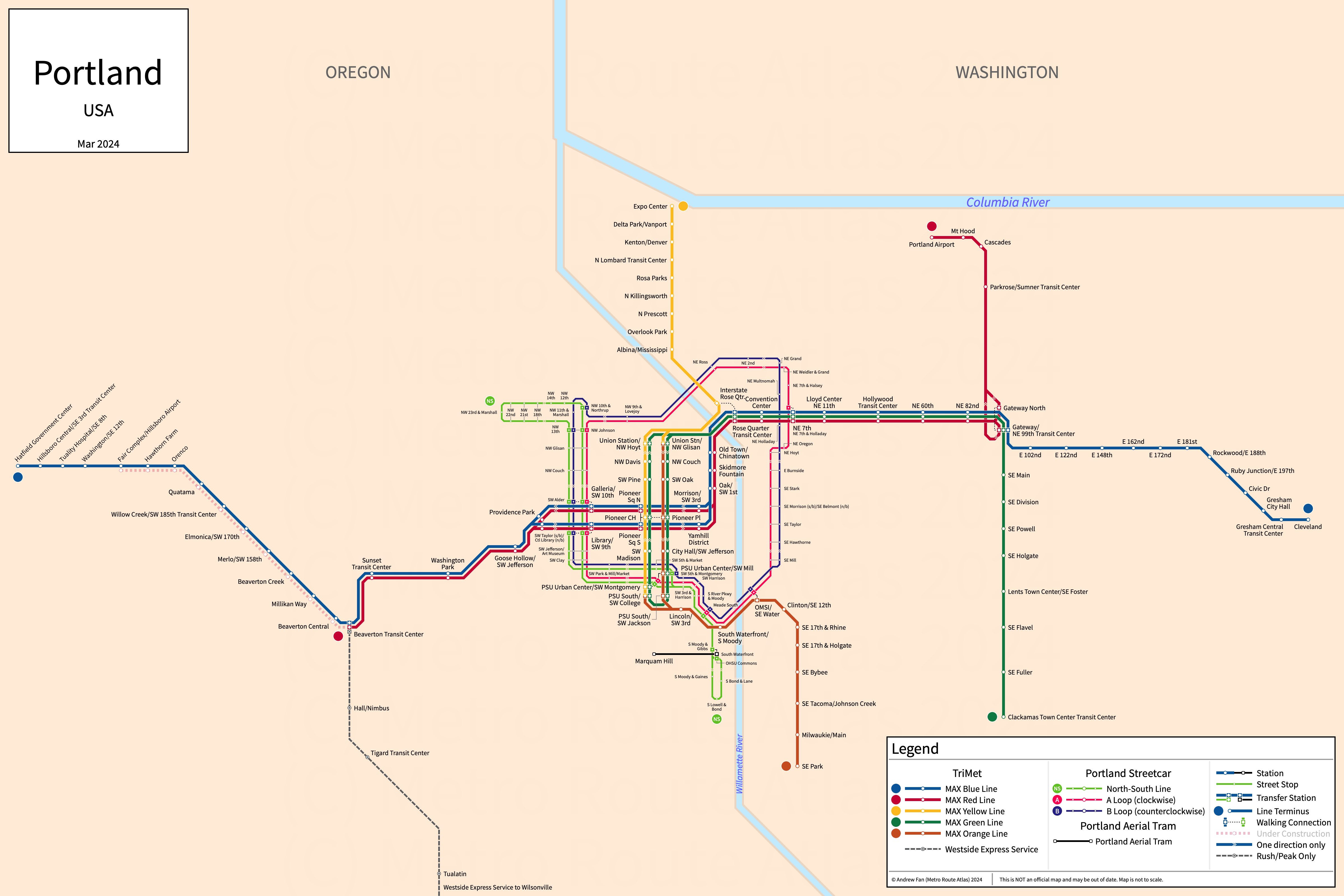
Table of Contents
Overview - Portland
Located on the Willamette River, Portland is the seat of Multnomah County and the largest city by population in Oregon. It has approximately 630,000 inhabitants in the city proper as of 2023. The Portland metropolitan area (Portland-Vancouver-Hillsboro) comprised 2,508,050 residents as of the 2023 US Census Bureau Estimate.
Portland's rapid transit network consists of four (officially five) light rail services. It also has three modern streetcar services, a commuter rail service, and an aerial tramway.
MAX Light Rail
Opened 1986, the MAX Light Rail network consists of four (officially five) light rail services that serve the city of Portland, Oregon and the surrounding suburbs.
Blue Line
The MAX Blue Line is a light rail service on an East-West alignment. It runs from Hatfield Government Center in Hillsboro in the west to Cleveland Avenue in Gresham in the east via downtown Portland, serving 45 stations (three of which are on separate streets in downtown Portland).
The MAX Blue Line was opened in September 1986 and the last extension to the line was the opening of Civic Drive in December 2010. Mall/SW 4th & 5th and Kings Hill/SW Salmon stations were closed on March 1, 2020 to speed up service. The MAX Blue Line is owned and operated by TriMet.
| Service | M-F Midday | M-F Rush | Sat. | Sun. | Notes |
|---|---|---|---|---|---|
| MAX Blue | 15' | 15' | 15' | 15' |
Schedules -- Last Updated: Apr 08, 2025
Red Line
The MAX Red Line is a light rail service on a Northeast-West alignment. It runs from Hillsboro Airport/Fairgrounds in the west to Portland International Airport in the east via downtown Portland, serving 33 stations (three of which are on separate streets in downtown Portland).
The MAX Red Line was opened in September 2001 and the last extension to the line was the extension of service to Hillsboro Airport/Fairgrounds in August 2024. Mall/SW 4th & 5th and Kings Hill/SW Salmon stations were closed on March 1, 2020 to speed up service. The MAX Red Line is owned and operated by TriMet.
| Service | M-F Midday | M-F Rush | Sat. | Sun. | Notes |
|---|---|---|---|---|---|
| MAX Red | 15' | 15' | 15' | 15' |
Schedules -- Last Updated: Apr 08, 2025
Green Line
The MAX Green Line is a light rail service on an upside down U shaped alignment. It runs from PSU South in the west to Clackamas Town Center Transit Center in the east via downtown Portland, serving 23 stations (seven of which are on separate streets in downtown Portland).
The MAX Green Line was opened in September 2009. The MAX Green Line is owned and operated by TriMet.
| Service | M-F Midday | M-F Rush | Sat. | Sun. | Notes |
|---|---|---|---|---|---|
| MAX Green | 15' | 15' | 15' | 15' |
Schedules -- Last Updated: Apr 08, 2025
Yellow & Orange Lines
The MAX Yellow and Orange Lines are a light rail service on a North-South alignment. They run from Expo Center in the north to Southeast Park Avenue in Milwaukie in the south via downtown Portland, serving 27 stations (seven of which are on separate streets in downtown Portland). Southbound Yellow Line trains become Orange Line trains at NW Glisan and northbound Orange Line trains become Yellow Line trains at PSU South/SW College. See this animation for more details.
The MAX Yellow Line was opened in May 2004. The MAX Orange Line was opened in September 2015. The MAX Yellow and Orange Lines are owned and operated by TriMet.
| Service | M-F Midday | M-F Rush | Sat. | Sun. | Notes |
|---|---|---|---|---|---|
| MAX Yellow-Orange | 15' | 15' | 15' | 15' | *1 |
Schedules (Yellow) Schedules (Orange) -- Last Updated: Apr 08, 2025
*1 - Yellow and Orange operate as a single service
Portland Streetcar
Opened 2001, the Portland Streetcar network consists of three modern streetcar services that serve the city of Portland, Oregon.
North-South Line
The North-South Line of the Portland Streetcar is a modern streetcar service on a North-South alignment. It runs from Northwest 23rd & Marshall in the north to Southwest Lowell & Bond in the south, serving 39 stops (including both single and bidirectional stops).
The North-South Line was opened in July 2001 and the last extension to the line was the extension to the South Waterfront in August 2007. The North-South Line is owned by the City of Portland and operated by Portland Streetcar and TriMet.
Central Loop Line (A & B Loops)
The A and B Loops of the Portland Streetcar are modern streetcar services on a loop alignment, serving 52 stops.
The Central Loop Line was opened in September 2012. Upon opening of the Tilikum Crossing in September 2015, the directions were branded as the A Loop (clockwise) and B Loop (counterclockwise). The Central Loop Line is owned by the City of Portland and operated by Portland Streetcar and TriMet.
WES Commuter Rail
Westside Express Service
The Westside Express Service is a commuter rail service on a North-South alignment. It runs from Beaverton in the north to Wilsonville in the south, serving 5 stations.
The Westside Express Service was opened in February 2009. The Westside Express Service is owned by TriMet and operated by the Portland and Western Railroad.
Portland Aerial Tram
Portland Aerial Tram
The Portland Aerial Tram is an aerial tramway on an East-West alignment. It runs from the South Waterfront in the east to Marquam Hill in the west, serving 2 stations.
The Portland Aerial Tram was opened in December 2006. The Portland Aerial Tram is owned by the City of Portland and operated by OHSU.
| Service | M-F Midday | M-F Rush | Sat. | Sun. | Notes |
|---|---|---|---|---|---|
| Portland Aerial Tram | 5' | 5' | 5' | No Service | *1 |
Schedules -- Last Updated: Apr 08, 2025
*1 - Sunday service is seasonal
References & Helpful Links
Portland Streetcar at Wikipedia
WES Commuter Rail at Wikipedia
Portland Aerial Tram at Wikipedia
Official Website for MAX Light Rail: TriMet
Official Website for Portland Streetcar: Portland Streetcar
Official Website for WES Commuter Rail: TriMet
Official Website for Portland Aerial Tram: Portland Aerial Tram
Maps
All Official Maps - TriMet [Last Accessed April 08, 2025]
Official System Map - TriMet [PDF] [Last Accessed April 08, 2025]
TriMet 'Fun With Maps' (May 2019)
Unofficial Map - TriMet (Vignelli Style) [2019] (www.trimet.org) [transitmap.net coverage] [Twitter Post]
Unofficial Map - TriMet (BART Style) [2019] (www.trimet.org) [transitmap.net coverage] [Twitter Post]
Unofficial Map - TriMet (WMATA Style) [2019] (www.trimet.org) [transitmap.net coverage] [Twitter Post]
Other Sources
Portland, USA at Urbanrail.net
Asset Notes
MAX Light Rail and WES Commuter Rail line colors taken from official TriMet Rail Map as of Jan 2020.
Portland Streetcar line colors taken from official Portland Streetcar Map as of Jan 2022 (from Jan 2020 map until Apr 08, 2025).