New Orleans, Louisiana, USA
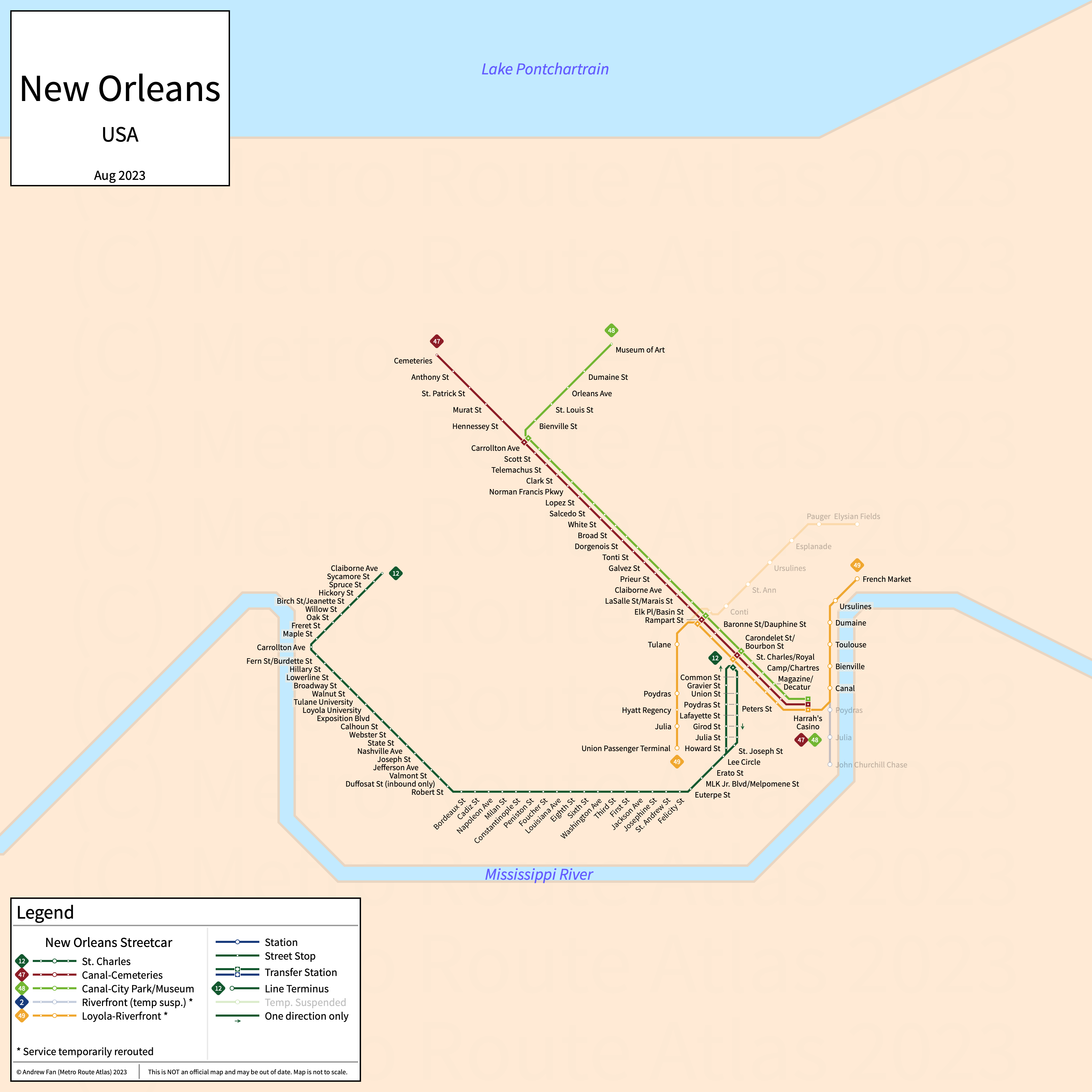
Table of Contents
Overview - New Orleans
Located on the Mississippi River south of Lake Pontchartrain, New Orleans is the largest city by population in Louisiana. It has approximately 364,000 inhabitants in the city proper as of 2023. The New Orleans metropolitan area (New Orleans-Metairie) comprised 962,165 residents as of the 2023 US Census Bureau Estimate.
New Orleans has four heritage streetcar services.
New Orleans Streetcar
Converted to electric trams in 1893, the New Orleans streetcar network consists of five heritage streetcar services that serve the city of New Orleans, Louisiana. Due to two segments of partially closed track, two of these services have been temporarily combined.
12 St. Charles
The St. Charles Streetcar is a heritage streetcar service on a U-shaped alignment. It runs from Claiborne in the west to Canal in the east via South Carrollton Ave and St. Charles Ave, serving 64 stops of which 18 are only served in a single direction.
As the oldest continuously operating streetcar in the world, the St. Charles Streetcar was opened in 1835. The last major change was in the 1950s when the line was cut back to Claiborne. The St. Charles Streetcar is owned and operated by the New Orleans Regional Transit Authority.
| Service | M-F Midday | M-F Rush | Sat. | Sun. | Notes |
|---|---|---|---|---|---|
| 12 St. Charles | 12-15' | 12-15' | 12-15' | 12-15' |
Schedules -- Last Updated: Mar 27, 2025
46 Rampart-Loyola
The Rampart-Loyola Streetcar (also known as Rampart-St. Claude) is a heritage streetcar service on a northeast-southwest alignment. It runs from Elysian Fields in the northeast to the Union Passenger Terminal in the southwest via Loyola, Rampart and St. Claude Avenues, serving 12 stops and stations.
The Rampart-Loyola Streetcar was opened in October 2016 as the Loyola-UPT Streetcar but was closed between October 2019 and May 2024 due to the collapse of the Hard Rock Hotel. The Rampart-Loyola Streetcar is owned and operated by the New Orleans Regional Transit Authority.
| Service | M-F Midday | M-F Rush | Sat. | Sun. | Notes |
|---|---|---|---|---|---|
| 46 Rampart-Loyola | 30' | 30' | 30' | 30' |
Schedules -- Last Updated: Mar 27, 2025
47 Canal-Cemeteries
The Canal-Cemeteries Streetcar is a heritage streetcar service on a northwest-southeast alignment. It runs from Cemeteries in the northwest to Canal in the southeast via Canal St, serving 29 stops.
The Canal-Cemeteries Streetcar was opened in 1861 and was reopened in April 2004 after having been closed in 1964. The Canal-Cemeteries Streetcar is owned and operated by the New Orleans Regional Transit Authority.
| Service | M-F Midday | M-F Rush | Sat. | Sun. | Notes |
|---|---|---|---|---|---|
| 47 Canal-Cemeteries | 22' | 22' | 22' | 22' |
Schedules -- Last Updated: Mar 27, 2025
48 Canal-City Park/Museum
The Canal-City Park/Museum Streetcar is a heritage streetcar service on a northwest-southeast alignment. It runs from Museum of Art in the northwest to Canal in the southeast via Canal St, serving 29 stops.
The Canal-City Park/Museum Streetcar was opened in April 2004. The Canal-City Park/Museum Streetcar is owned and operated by the New Orleans Regional Transit Authority.
| Service | M-F Midday | M-F Rush | Sat. | Sun. | Notes |
|---|---|---|---|---|---|
| 48 Canal-City Park/Museum | 22' | 22' | 22' | 22' |
Schedules -- Last Updated: Mar 27, 2025
49 Loyola-Riverfront
The Loyola-Riverfront Streetcar is a heritage streetcar service on an east-west alignment. It runs from Union Passenger Terminal in the west to French Market in the east via Loyola Avenue and the Riverfront Streetcar, serving 19 stops and stations.
The Loyola-Riverfront Streetcar was opened in 2021 as a combined 2/46 service due to the Hard Rock Hotel collapse, but was retained after reinstatement of the 46 in May 2024. The Loyola-Riverfront Streetcar is owned and operated by the New Orleans Regional Transit Authority.
| Service | M-F Midday | M-F Rush | Sat. | Sun. | Notes |
|---|---|---|---|---|---|
| 49 Loyola-Riverfront | 30' | 30' | 30' | 30' |
Schedules -- Last Updated: Mar 27, 2025
References & Helpful Links
New Orleans Streetcars at Wikipedia
Official Website for New Orleans Streetcars: New Orleans Regional Transit Authority
Maps
Official System Map - New Orleans Streetcar [PDF] [Last Accessed March 27, 2025]
Other Sources
New Orleans, USA at Urbanrail.net
Asset Notes
Original colors for lines were taken from the bullets on the official Streetcar map as of September 12, 2020 (49 uses color from 46 bus bridge). New colors as of 46 reopening use the official Streetcar map as of August 1, 2024.