Los Angeles, California, USA
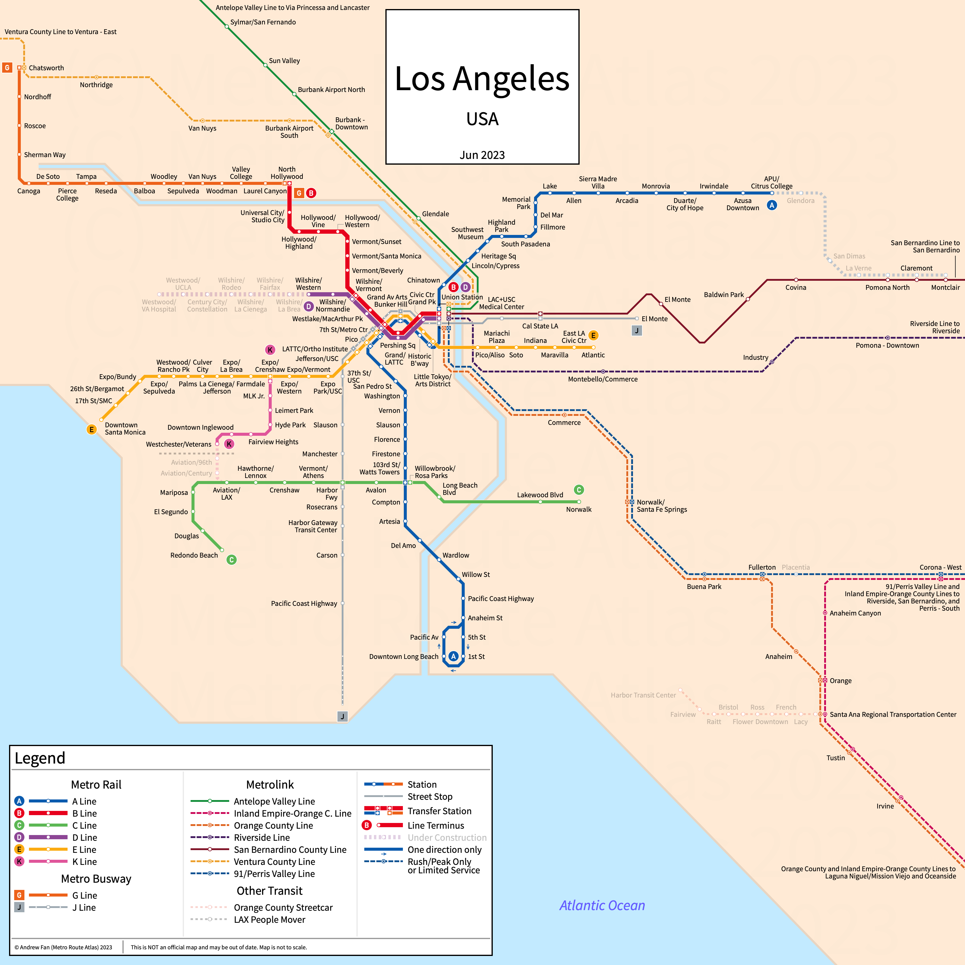
Table of Contents
Overview - Los Angeles
Located on the Pacific Ocean in southern California, Los Angeles is the largest city by population in California and the second largest city by population in the United States of America. It has approximately 3.812 million inhabitants in the city proper as of 2023. The Los Angeles metropolitan area (Los Angeles-Long Beach-Anaheim) comprised 12,799,100 residents as of the 2023 US Census Bureau Estimate.
Los Angeles rapid transit network consists of two metro services, four light rail services, and a bus rapid transit service. It also has a rapid bus service and commuter rail services.
Los Angeles Metro Rail
Opened 1990, Los Angeles Metro Rail consists of two metro services and four light rail services that serve the cities of Los Angeles County, California. All services are operated by the Los Angeles County Metropolitan Transportation Authority (Metro).
A Line
The A Line, formerly the Blue Line, of the Los Angeles Metro is a light rail service on a Northeast-Southwest alignment, running from Long Beach in the southwest to APU/Citrus College in the northeast and serving 44 stations of which four are served in a single directional loop.
The A Line was opened in July 1990 and the latest extension was the opening of the regional connector and subsequent assignment of the north branch of the former Gold Line to the A Line in June 2023.
B Line
The B Line, formerly the Red Line, of the Los Angeles Metro is a metro service on a East-Northwest alignment, running from Union Station in the east to North Hollywood in the northwest and serving 14 stations.
The B Line was opened in January 1993 and the last extension to the line was in 2000 when the line was extended from Hollywood/Vine to North Hollywood.
C Line
The C Line, formerly the Green Line, of the Los Angeles Metro is a light rail service on an East-West alignment, running from LAX/Metro Transit Center in the west to Norwalk in the east and serving 12 stations. East of Aviation/LAX, the line lies within the I-105 freeway.
The C Line was opened in August 1995. In November 2024, the line was rerouted to Aviation Century, and its former western end was transferred to the K Line. The last extension was to LAX/Metro Transit Center in June 2025.
| Service | M-F Midday | M-F Rush | Sat. | Sun. | Notes |
|---|---|---|---|---|---|
| C | 10' | 10' | 10' | 10' |
Schedules -- Last Updated: Jun 7, 2025
D Line
The D Line, formerly the Purple Line, of the Los Angeles Metro is a metro service on an East-West alignment, running from Union Station in the east to Wilshire/Western in the west and serving 8 stations.
The D Line was opened in January 1993 as a branch of the Red Line and was branded as its own line in 2006.
| Service | M-F Midday | M-F Rush | Sat. | Sun. | Notes |
|---|---|---|---|---|---|
| D | Temporarily Suspended | Temporarily Suspended | Temporarily Suspended | Temporarily Suspended |
Schedules -- Last Updated: Jun 7, 2025
E Line
The E Line, formerly the Expo Line, of the Los Angeles Metro is a light rail service on an East-West alignment, running from Atlantic in the east to Downtown Santa Monica in the west and serving 29 stations.
The E Line was opened in April 2012 as the Expo Line and the latest extension was the opening of the regional connector and subsequent assignment of the south branch of the former Gold Line to the E Line in June 2023.
K Line
The K Line, formerly the Crenshaw/LAX Line, of the Los Angeles Metro is a light rail service on a North-South alignment, running from Redondo Beach in the south to Expo/Crenshaw in the north and serving 13 stations.
The K Line was opened in October 2022. In November 2024, the western portion of the C Line from Redondo Beach to a new station at Aviation/Century was transferred to the K Line. The last extension was the opening of the segment surrounding the LAX/Metro Transit Center in June 2025.
| Service | M-F Midday | M-F Rush | Sat. | Sun. | Notes |
|---|---|---|---|---|---|
| K | 10' | 10' | 10' | 10' |
Schedules -- Last Updated: Jun 7, 2025
Los Angeles Metro Busway
Opened 2005, Los Angeles Metro Busway consists of a bus rapid transit corridor and two rapid bus corridors consolidated into two branded services that serve the cities of Los Angeles County, California. All services are operated by the Los Angeles County Metropolitan Transportation Authority (Metro).
G Line
The G Line, formerly the Orange Line, of the Los Angeles Metro is a bus rapid transit service on an East-West alignment, running from Chatswood in the west to North Hollywood in the east along a disused railway ROW and serving 17 stations.
The G Line was opened in October 2005. The last extension was the Chatsworth Extension, opened in June 2012. Service to Warner Center was terminated on June 2018.
| Service | M-F Midday | M-F Rush | Sat. | Sun. | Notes |
|---|---|---|---|---|---|
| G | 10' | 6' | 10' | 10' | *1 |
Schedules -- Last Updated: Jun 7, 2025
*1 - About half of the buses terminate at Canoga and do not continue to Chatsworth
J Line
The J Line, formerly the Silver Line, of the Los Angeles Metro is a rapid bus service on a Northeast-South alignment, running from El Monte in the northeast to the Harbor Gateway Transit Center and San Pedro in the south via Union Station and serving 12 stations with additional street stops. East of Union Station, the J Line runs on the El Monte Busway and in the south it runs on the Harbor Transitway.
The J Line service began in December 2009. The El Monte Busway opened in 1973 while the Harbor Transitway opened in June 1996.
| Service | M-F Midday | M-F Rush | Sat. | Sun. | Notes |
|---|---|---|---|---|---|
| J | 10' | 5' | 15' | 15' | *1 |
Schedules -- Last Updated: Jun 7, 2025
*1 - Most buses terminate at Harbor Gateway TC and do not continue to Pacific & 21st. On weekends, it is every other bus.
Metrolink
Opened in its current form in 1992, Metrolink consists of seven commuter rail services primarily based out of Los Angeles Union Station, serving Los Angeles, San Bernardino, Orange, Riverside, San Diego, and Ventura Counties.
Antelope Valley Line
The Antelope Valley Line of Metrolink is a commuter rail service on a North-South alignment, running from Los Angeles Union Station in the south to Lancaster in the north and serving 13 stations.
The Antelope Valley Line service began in October 1992. The last expansion was the opening of the Vista Canyon station in October 2023.
Inland Empire-Orange County Line
The Inland Empire-Orange County Line of Metrolink is a commuter rail service on a North-South alignment, running from Oceanside in the south to San Bernardino-Downtown in the north and serving 16 stations.
The Inland Empire-Orange County Line service began in October 1995.
Orange County Line
The Orange County Line of Metrolink is a commuter rail service on a North-South alignment, running from Oceanside in the south to Los Angeles Union Station in the north and serving 15 stations.
The Orange County Line service began in April 1990.
Riverside Line
The Riverside Line of Metrolink is a commuter rail service on an East-West alignment, running from Los Angeles Union Station in the west to Riverside in the east and serving 7 stations. It primarily runs weekday peak hours only.
The Riverside Line service began in June 1993.
San Bernardino Line
The San Bernardino Line of Metrolink is a commuter rail service on an East-West alignment, running from Los Angeles Union Station in the west to San Bernardino - Downtown in the east and serving 14 stations. As of October 2022, a single train a day extends to Redlands - Downtown, but we do not show this on the strip map above as it essentially does not exist.
The San Bernardino Line service began in 1992. Service was extended to San Bernardino in 1993 and limited service began to Redlands - Downtown in October 2022.
Ventura County Line
The Ventura County Line of Metrolink is a commuter rail service on an East-West alignment, running from East Ventura in the west to Los Angeles Union Station in the east and serving 12 stations.
The Ventura County Line service began in 1992.
91/Perris Valley Line
The 91/Perris Valley Line of Metrolink is a commuter rail service on an East-West alignment, running from Los Angeles Union Station in the west to Perris South via Riverside and serving 12 stations. It parallels State Route 91 for much of its length west of Riverside.
The 91/Perris Valley Line service began in 2002. The latest extension to the service was the Perris Valley extension in June 2016.
References & Helpful Links
Los Angeles Metro Rail at Wikipedia
Los Angeles Metro Busway at Wikipedia
Official Website for Los Angeles Metro: Metro
Official Website for Metrolink: Metrolink
Maps
All Official Maps - LA Metro [Last Accessed Jun 7, 2025]
Official System Map - Metro Rail & Busway [PDF] [Last Accessed Jun 7, 2025]
All Official Maps - Metrolink [Last Accessed Jun 7, 2025]
Official System Map - Metrolink [PDF] [Last Accessed Jun 7, 2025]
Unofficial Map - Los Angeles Rapid Transit by Steve Boland (calurbanist.com)
Unofficial Map - Los Angeles Metro Rail and Busway by Fern K Hahn (fernkhahn.com)
Other Sources
Los Angeles, USA at Urbanrail.net
Los Angeles, USA at BRTDATA.org
Asset Notes
Metro Rail colors all taken from official Metro map as of September 2019, except K Line which was taken from the official Metro map as of October 7, 2022.
Metrolink colors all taken from official Metrolink map as of September 2019. Metrolink color taken from official Metrolink map as of September 2019 from official logo.
Orange County Streetcar line color taken from Project Map as of September 2019.